Hancock, Massachusetts
Submit your own pictures of this town and show them to the world
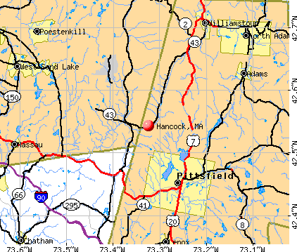
- OSM Map
- General Map
- Google Map
- MSN Map
Population change since 2000: -0.6%
| Males: 362 | |
| Females: 355 |
| Median resident age: | 46.8 years |
| Massachusetts median age: | 39.2 years |
Zip codes: 01237.
| Hancock: | $86,144 |
| MA: | $94,488 |
Estimated per capita income in 2022: $49,907 (it was $22,250 in 2000)
Hancock town income, earnings, and wages data
Estimated median house or condo value in 2022: $357,540 (it was $133,700 in 2000)
| Hancock: | $357,540 |
| MA: | $534,700 |
Mean prices in 2022: all housing units: $357,971; detached houses: $376,086; townhouses or other attached units: $341,816; in 2-unit structures: $250,940; in 3-to-4-unit structures: $400,871; in 5-or-more-unit structures: $281,990; mobile homes: $80,872
Detailed information about poverty and poor residents in Hancock, MA


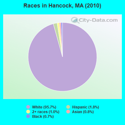
- 68695.7%White alone
- 131.8%Hispanic
- 71.0%Two or more races
- 60.8%Asian alone
- 50.7%Black alone
Races in Hancock detailed stats: ancestries, foreign born residents, place of birth
 Recent articles from our blog. Our writers, many of them Ph.D. graduates or candidates, create easy-to-read articles on a wide variety of topics.

 | Suggestion for Reopening John Hancock Tower Observation Deck (11 replies) |
| Quincy to open "migrant" shelter in Wollaston (251 replies) |
| Mass migration: People continue to leave the state (143 replies) |
| Man shot last night in Quincy (39 replies) |
| What is the most iconic building or structure in Boston? (67 replies) |
| Boston Photo Thread (397 replies) |
Latest news from Hancock, MA collected exclusively by city-data.com from local newspapers, TV, and radio stations
Hancock, MA City Guides:
Ancestries: English (20.0%), Irish (19.7%), Italian (18.2%), French (11.5%), German (9.7%), United States (9.4%).
Current Local Time: EST time zone
Incorporated in 1776
Elevation: 1058 feet
Land area: 35.7 square miles.
Population density: 20 people per square mile (very low).
12 residents are foreign born
| This town: | 1.7% |
| Massachusetts: | 12.2% |
| Hancock town: | 0.5% ($689) |
| Massachusetts: | 1.3% ($2,336) |
Nearest city with pop. 50,000+: Albany, NY  (25.0 miles , pop. 95,658).
Nearest city with pop. 200,000+: Boston, MA (114.7 miles , pop. 589,141).
Nearest city with pop. 1,000,000+: Bronx, NY (120.9 miles , pop. 1,332,650).
Nearest cities:
), ), ), )Latitude: 42.54 N, Longitude: 73.32 W
Area code: 413

Hancock tourist attractions:
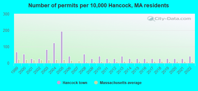
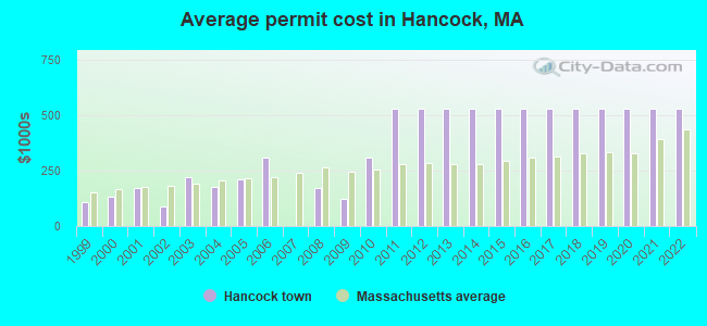
Single-family new house construction building permits:
- 2022: 3 buildings, average cost: $530,400
- 2021: 2 buildings, average cost: $530,400
- 2020: 2 buildings, average cost: $530,400
- 2019: 2 buildings, average cost: $530,400
- 2018: 2 buildings, average cost: $530,400
- 2017: 2 buildings, average cost: $530,400
- 2016: 2 buildings, average cost: $530,400
- 2015: 2 buildings, average cost: $530,400
- 2014: 2 buildings, average cost: $530,400
- 2013: 3 buildings, average cost: $530,400
- 2012: 2 buildings, average cost: $530,400
- 2011: 2 buildings, average cost: $530,400
- 2010: 3 buildings, average cost: $307,300
- 2009: 2 buildings, average cost: $121,600
- 2008: 4 buildings, average cost: $170,600
- 2006: 3 buildings, average cost: $310,900
- 2005: 14 buildings, average cost: $211,200
- 2004: 9 buildings, average cost: $178,200
- 2003: 6 buildings, average cost: $219,200
- 2002: 2 buildings, average cost: $88,600
- 2001: 2 buildings, average cost: $170,000
- 2000: 4 buildings, average cost: $130,800
- 1999: 5 buildings, average cost: $107,500
| Here: | 2.1% |
| Massachusetts: | 3.5% |
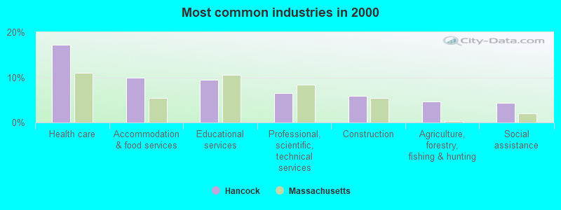
- Health care (17.3%)
- Accommodation & food services (10.0%)
- Educational services (9.4%)
- Professional, scientific, technical services (6.5%)
- Construction (5.9%)
- Agriculture, forestry, fishing & hunting (4.6%)
- Social assistance (4.3%)
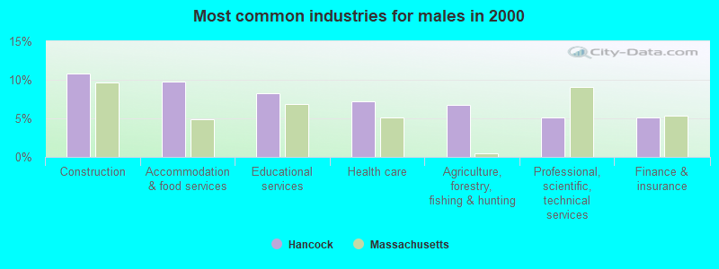
- Construction (10.8%)
- Accommodation & food services (9.8%)
- Educational services (8.2%)
- Health care (7.2%)
- Agriculture, forestry, fishing & hunting (6.7%)
- Professional, scientific, technical services (5.2%)
- Finance & insurance (5.2%)
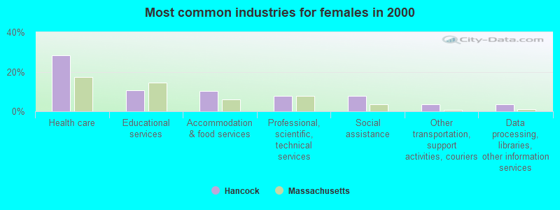
- Health care (28.2%)
- Educational services (10.7%)
- Accommodation & food services (10.2%)
- Professional, scientific, technical services (7.9%)
- Social assistance (7.9%)
- Other transportation, support activities, couriers (3.4%)
- Data processing, libraries, other information services (3.4%)
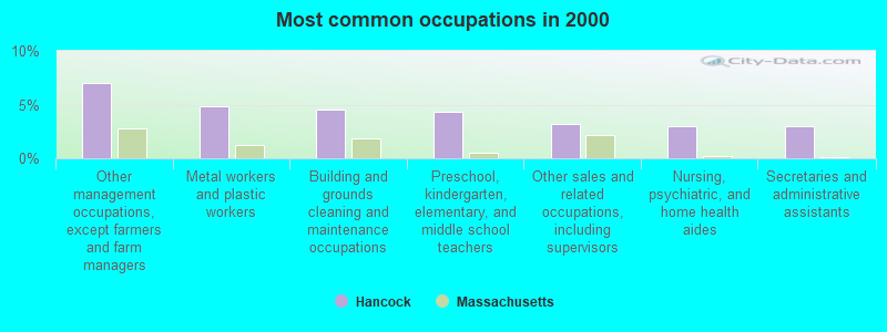
- Other management occupations, except farmers and farm managers (7.0%)
- Metal workers and plastic workers (4.9%)
- Building and grounds cleaning and maintenance occupations (4.6%)
- Preschool, kindergarten, elementary, and middle school teachers (4.3%)
- Other sales and related occupations, including supervisors (3.2%)
- Nursing, psychiatric, and home health aides (3.0%)
- Secretaries and administrative assistants (3.0%)
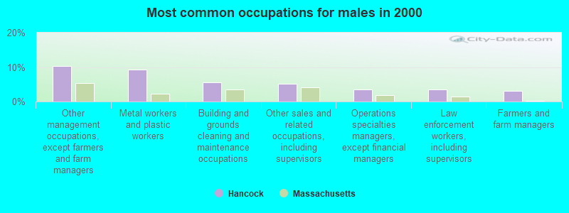
- Other management occupations, except farmers and farm managers (10.3%)
- Metal workers and plastic workers (9.3%)
- Building and grounds cleaning and maintenance occupations (5.7%)
- Other sales and related occupations, including supervisors (5.2%)
- Operations specialties managers, except financial managers (3.6%)
- Law enforcement workers, including supervisors (3.6%)
- Farmers and farm managers (3.1%)

- Preschool, kindergarten, elementary, and middle school teachers (7.3%)
- Information and record clerks, except customer service representatives (5.6%)
- Secretaries and administrative assistants (5.1%)
- Nursing, psychiatric, and home health aides (5.1%)
- Registered nurses (5.1%)
- Supervisors and other personal care and service workers, except child care workers (4.5%)
- Health technologists and technicians (4.5%)
Average climate in Hancock, Massachusetts
Based on data reported by over 4,000 weather stations


(lower is better)
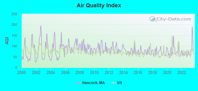
Air Quality Index (AQI) level in 2023 was 89.6. This is worse than average.
| City: | 89.6 |
| U.S.: | 72.6 |
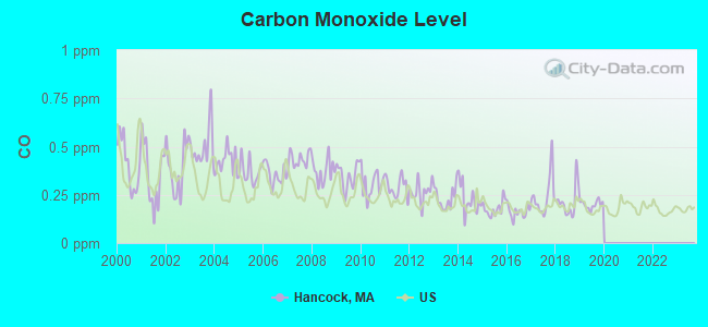
Carbon Monoxide (CO) [ppm] level in 2019 was 0.199. This is better than average. Closest monitor was 7.2 miles away from the city center.
| City: | 0.199 |
| U.S.: | 0.251 |
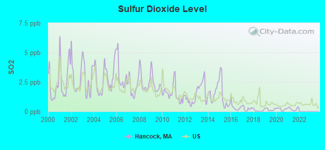
Sulfur Dioxide (SO2) [ppb] level in 2021 was 0.213. This is significantly better than average. Closest monitor was 7.2 miles away from the city center.
| City: | 0.213 |
| U.S.: | 1.515 |
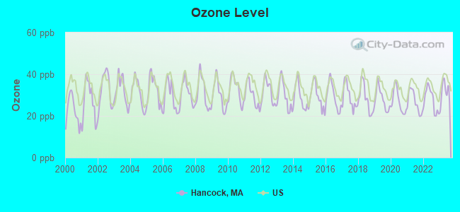
Ozone [ppb] level in 2023 was 31.1. This is about average. Closest monitor was 7.2 miles away from the city center.
| City: | 31.1 |
| U.S.: | 33.3 |
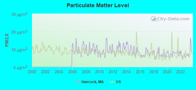
Particulate Matter (PM2.5) [µg/m3] level in 2023 was 8.88. This is about average. Closest monitor was 7.1 miles away from the city center.
| City: | 8.88 |
| U.S.: | 8.11 |
Tornado activity:
Hancock-area historical tornado activity is slightly above Massachusetts state average. It is 25% smaller than the overall U.S. average.
On 8/28/1973, a category F4 (max. wind speeds 207-260 mph) tornado 10.1 miles away from the Hancock town center killed 4 people and injured 36 people and caused between $5,000,000 and $50,000,000 in damages.
On 5/29/1995, a category F4 tornado 24.5 miles away from the town center killed 3 people and injured 24 people and caused between $5,000,000 and $50,000,000 in damages.
Earthquake activity:
Hancock-area historical earthquake activity is significantly above Massachusetts state average. It is 68% smaller than the overall U.S. average.On 10/7/1983 at 10:18:46, a magnitude 5.3 (5.1 MB, 5.3 LG, 5.1 ML, Class: Moderate, Intensity: VI - VII) earthquake occurred 110.3 miles away from Hancock center
On 4/20/2002 at 10:50:47, a magnitude 5.3 (5.3 ML, Depth: 3.0 mi) earthquake occurred 137.4 miles away from the city center
On 4/20/2002 at 10:50:47, a magnitude 5.2 (5.2 MB, 4.2 MS, 5.2 MW, 5.0 MW) earthquake occurred 135.9 miles away from the city center
On 1/19/1982 at 00:14:42, a magnitude 4.7 (4.5 MB, 4.7 MD, 4.5 LG, Class: Light, Intensity: IV - V) earthquake occurred 109.1 miles away from the city center
On 10/16/2012 at 23:12:25, a magnitude 4.7 (4.7 ML, Depth: 10.0 mi) earthquake occurred 152.8 miles away from Hancock center
On 6/17/1991 at 08:53:16, a magnitude 4.1 (4.0 MB, 4.0 LG, Depth: 3.1 mi) earthquake occurred 69.6 miles away from the city center
Magnitude types: regional Lg-wave magnitude (LG), body-wave magnitude (MB), duration magnitude (MD), local magnitude (ML), surface-wave magnitude (MS), moment magnitude (MW)
Natural disasters:
The number of natural disasters in Berkshire County (21) is greater than the US average (15).Major Disasters (Presidential) Declared: 10
Emergencies Declared: 10
Causes of natural disasters: Floods: 5, Snowstorms: 5, Storms: 5, Hurricanes: 4, Winter Storms: 4, Blizzards: 2, Snows: 2, Snowfall: 1, Tropical Storm: 1, Wind: 1, Other: 1 (Note: some incidents may be assigned to more than one category).

Hospitals and medical centers near Hancock:
- HILLCREST COMMONS NURSING AND REHABILITATION CENTER (Nursing Home, about 7 miles away; PITTSFIELD, MA)
- BERKSHIRE VISITING NURSE ASSOCIATION (Home Health Center, about 7 miles away; PITTSFIELD, MA)
- HILLCREST HOSPITAL (Hospital, about 7 miles away; PITTSFIELD, MA)
- MT GREYLOCK EXTENDED CARE FACILITY (Nursing Home, about 7 miles away; PITTSFIELD, MA)
- BERKSHIRE MEDICAL CENTER INC Acute Care Hospitals (about 7 miles away; PITTSFIELD, MA)
- CENTER FOR OPTIMUM CARE-BERKSHIRE (Nursing Home, about 8 miles away; PITTSFIELD, MA)
- BERKSHIRE PLACE (Nursing Home, about 8 miles away; PITTSFIELD, MA)
Colleges/universities with over 2000 students nearest to Hancock:
- Williams College (about 13 miles; Williamstown, MA; Full-time enrollment: 2,141)
- Hudson Valley Community College (about 22 miles; Troy, NY; FT enrollment: 9,346)
- Rensselaer Polytechnic Institute (about 23 miles; Troy, NY; FT enrollment: 6,940)
- The Sage Colleges (about 24 miles; Troy, NY; FT enrollment: 2,499)
- Siena College (about 26 miles; Loudonville, NY; FT enrollment: 3,153)
- The College of Saint Rose (about 26 miles; Albany, NY; FT enrollment: 4,085)
- SUNY at Albany (about 28 miles; Albany, NY; FT enrollment: 15,490)
Public elementary/middle school in Hancock:
- HANCOCK ELEMENTARY (Students: 44, Location: 3080 HANCOCK ROAD, Grades: PK-6)
User-submitted facts and corrections:
- When I was a younger man, I hunted Hancock valley every deer season. I stumbled upon an old family burial site in the wood that seems to have been forgotten, if even known of. The family name was Hakes. There were two grave stones partialy legible, one being that of a two or three year old boy who died in 1802 or 1803. I am 75 years old and am no longer able to walk in the woods. This cemetary is in the woods above the brook, behind the Town Cemetary. Does anyone know anything about this family or burial site? I have spoken with residents of the valley and so far have found no one with knowledge of this family. I would appreciate any information that anyone has concerning this cemetary and its residents. Each year that I hunted the valley, I would go to this site and pay homage to its long departed family. added by buddyu32@aol.com
Points of interest:
Notable locations in Hancock: Jiminy Peak Ski Area (A), Hancock Fire Department Station 2 (B), Hancock Fire Department Station 1 Headquarters (C), Hancock Town Hall (D). Display/hide their locations on the map
Cemeteries: Gardner Cemetery (1), Hancock Cemetery (2). Display/hide their locations on the map
Lakes, reservoirs, and swamps: Cranberry Pond (A), Berry Pond (B), Twin Pond (C), Shaker Reservoir (D), Tilden Swamp (E). Display/hide their locations on the map
Streams, rivers, and creeks: Whitman Brook (A), Red Oak Brook (B), Rathburn Brook (C), North Branch Mount Lebanon Brook (D), Jones Brook (E), Bentley Brook (F). Display/hide their locations on the map
Parks in Hancock include: Bates Memorial State Park (1), Forbush Wildlife Sanctuary (2). Display/hide their locations on the map
Drinking water stations with addresses in Hancock and their reported violations in the past:
JIMINY PEAK RESORT (Population served: 1,000, Groundwater):Past health violations:BEAVER POND MEADOWS (Population served: 160, Groundwater):Past monitoring violations:
- MCL, Monthly (TCR) - In SEP-2013, Contaminant: Coliform. Follow-up actions: St AO (w/o penalty) issued (OCT-18-2013)
- MCL, Monthly (TCR) - In OCT-2011, Contaminant: Coliform. Follow-up actions: St AO (w/o penalty) issued (2 times from OCT-14-2011 to DEC-20-2011)
- One routine major monitoring violation
- One minor monitoring violation
Past health violations:
- MCL, Monthly (TCR) - In JUN-2013, Contaminant: Coliform. Follow-up actions: St AO (w/o penalty) issued (JUL-22-2013)
| This town: | 2.4 people |
| Massachusetts: | 2.5 people |
| This town: | 65.9% |
| Whole state: | 63.0% |
| This town: | 7.0% |
| Whole state: | 7.0% |
Likely homosexual households (counted as self-reported same-sex unmarried-partner households)
- Lesbian couples: 0.0% of all households
- Gay men: 0.7% of all households
| This town: | 5.7% |
| Whole state: | 9.3% |
| This town: | 0.6% |
| Whole state: | 4.4% |
For population 15 years and over in Hancock:
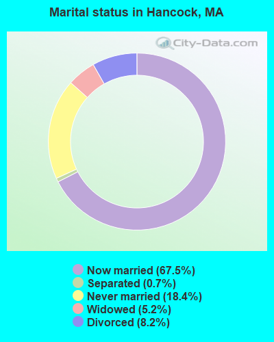
- Never married: 18.4%
- Now married: 67.5%
- Separated: 0.7%
- Widowed: 5.2%
- Divorced: 8.2%
For population 25 years and over in Hancock:
- High school or higher: 89.4%
- Bachelor's degree or higher: 29.5%
- Graduate or professional degree: 11.9%
- Unemployed: 5.6%
- Mean travel time to work (commute): 26.0 minutes
| Here: | 10.5 |
| Massachusetts average: | 13.1 |


Graphs represent county-level data. Detailed 2008 Election Results
Religion statistics for Hancock, MA (based on Berkshire County data)


| Religion | Adherents | Congregations |
|---|---|---|
| Catholic | 50,187 | 32 |
| Mainline Protestant | 9,895 | 63 |
| Other | 3,647 | 20 |
| Evangelical Protestant | 2,817 | 28 |
| Black Protestant | 233 | 2 |
| Orthodox | 225 | 2 |
| None | 64,215 | - |
Food Environment Statistics:
| Berkshire County: | 2.54 / 10,000 pop. |
| Massachusetts: | 1.98 / 10,000 pop. |
| Berkshire County: | 1.61 / 10,000 pop. |
| Massachusetts: | 2.22 / 10,000 pop. |
| Berkshire County: | 4.08 / 10,000 pop. |
| Massachusetts: | 1.77 / 10,000 pop. |
| This county: | 15.00 / 10,000 pop. |
| State: | 8.76 / 10,000 pop. |
| Berkshire County: | 8.0% |
| State: | 8.1% |
| This county: | 22.8% |
| Massachusetts: | 22.5% |
| Here: | 9.9% |
| Massachusetts: | 16.5% |
Strongest AM radio stations in Hancock:
- WUHN (1110 AM; daytime; 5 kW; PITTSFIELD, MA; Owner: WEINER BROADCASTING, INC.)
- WNNZ (640 AM; 50 kW; WESTFIELD, MA; Owner: CLEAR CHANNEL BROADCASTING LICENSES, INC.)
- WGY (810 AM; 50 kW; SCHENECTADY, NY; Owner: CLEAR CHANNEL BROADCASTING LICENSES, INC.)
- WPTR (1540 AM; 50 kW; ALBANY, NY; Owner: KIMTRON, INC.)
- WBEC (1420 AM; 1 kW; PITTSFIELD, MA; Owner: GREAT NORTHERN RADIO, LLC)
- WROW (590 AM; 5 kW; ALBANY, NY; Owner: 6 JOHNSON ROAD LICENSES, INC.)
- WTIC (1080 AM; 50 kW; HARTFORD, CT; Owner: INFINITY RADIO OPERATIONS INC.)
- WBRK (1340 AM; 1 kW; PITTSFIELD, MA; Owner: WBRK, INC.)
- WCRN (830 AM; 50 kW; WORCESTER, MA; Owner: CARTER BROADCASTING CORPORATION)
- WTMM (1300 AM; 5 kW; RENSSELAER, NY; Owner: REGENT LICENSEE OF MANSFIELD, INC.)
- WVNE (760 AM; daytime; 25 kW; LEICESTER, MA; Owner: BLOUNT MASSCOM, INC.)
- WRKO (680 AM; 50 kW; BOSTON, MA; Owner: ENTERCOM BOSTON LICENSE, LLC)
- WSBS (860 AM; 3 kW; GREAT BARRINGTON, MA; Owner: BERKSHIRE BROADCASTING CO., INC.)
Strongest FM radio stations in Hancock:
- WAMC-FM (90.3 FM; ALBANY, NY; Owner: WAMC)
- WBEC-FM (105.5 FM; PITTSFIELD, MA; Owner: GREAT NORTHERN RADIO, LLC)
- WUPE (95.9 FM; PITTSFIELD, MA; Owner: WEINER BROADCASTING, INC.)
- WZEC (97.5 FM; HOOSICK FALLS, NY; Owner: GREAT NORTHERN RADIO, LLC)
- WHVP (91.1 FM; HUDSON, NY; Owner: SOUND OF LIFE, INC.)
- WEQX (102.7 FM; MANCHESTER, VT; Owner: NORTHSHIRE COMMUNICATIONS, INC.)
- WBRK-FM (101.7 FM; PITTSFIELD, MA; Owner: WBRK, INC.)
- WJAN (95.1 FM; SUNDERLAND, VT; Owner: 6 JOHNSON ROAD LICENSES, INC.)
- WVAY (100.7 FM; WILMINGTON, VT; Owner: GREAT NORTHERN RADIO, L.L.C.)
- WMNB (100.1 FM; NORTH ADAMS, MA; Owner: BERKSHIRE BROADCASTING CO., INC.)
- WAMQ (105.1 FM; GREAT BARRINGTON, MA; Owner: WAMC)
- WAJZ (96.3 FM; VOORHEESVILLE, NY; Owner: 6 JOHNSON ROAD LICENSES, INC.)
- WZMR (104.9 FM; ALTAMONT, NY; Owner: 6 JOHNSON ROAD LICENSES, INC.)
- WYJB (95.5 FM; ALBANY, NY; Owner: 6 JOHNSON ROAD LICENSES, INC.)
- WGNA-FM (107.7 FM; ALBANY, NY; Owner: REGENT LICENSEE OF MANSFIELD, INC.)
- WRVE (99.5 FM; SCHENECTADY, NY; Owner: CLEAR CHANNEL BROADCASTING LICENSES, INC.)
- WMHT-FM (89.1 FM; SCHENECTADY, NY; Owner: WMHT EDUCATIONAL TELECOMMUNICATIONS)
- WAMK (90.9 FM; KINGSTON, NY; Owner: W A M C)
- WPYX (106.5 FM; ALBANY, NY; Owner: CAPSTAR TX LIMITED PARTNERSHIP)
- WFGB (89.7 FM; KINGSTON, NY; Owner: SOUND OF LIFE, INC.)
TV broadcast stations around Hancock:
- WCDC-TV (Channel 19; ADAMS, MA; Owner: YOUNG BROADCASTING OF ALBANY, INC.)
- W38DL (Channel 38; ADAMS, ETC., MA; Owner: WNYT-TV, LLC)
- WNGN-LP (Channel 26; TROY, NY; Owner: BRIAN A. LARSON)
Hancock fatal accident list:
Mar 14, 2012 08:20 PM, Us-20 Lebanon Mountain Road, Lat: 42.447558, Lon: -73.374253, Vehicles: 1, Persons: 1, Fatalities: 1
Apr 27, 2012 08:09 PM, Brodie Mountain Road, Lat: 42.562353, Lon: -73.288222, Vehicles: 2, Persons: 3, Fatalities: 1
Oct 14, 1998 06:40 AM, Us-20, Vehicles: 2, Persons: 2, Fatalities: 1
Mar 2, 1995 05:23 PM, Rte 43, Vehicles: 2, Persons: 3, Fatalities: 1
Jul 21, 1988 08:05 AM, Rte.28, Vehicles: 2, Persons: 2, Fatalities: 1, Drunk persons involved: 1
- National Bridge Inventory (NBI) Statistics
- 5Number of bridges
- 20ft / 6.5mTotal length
- $2,565,000Total costs
- 10,249Total average daily traffic
- 608Total average daily truck traffic
- 9,333Total future (year 2031) average daily traffic
FCC Registered Cell Phone Towers:
1 (See the full list of FCC Registered Cell Phone Towers in Hancock)FCC Registered Antenna Towers:
14 (See the full list of FCC Registered Antenna Towers)FCC Registered Broadcast Land Mobile Towers:
4- E Us Rt 20 1/2mi W Rts 41 & 20 (Lat: 42.438694 Lon: -73.361500), Call Sign: KNAV435, Licensee ID: L00015054,
Assigned Frequencies: 47.6800 MHz, Grant Date: 12/16/2000, Expiration Date: 02/26/2011, Cancellation Date: 04/30/2011, Registrant: L R Sweatland Inc, Pittsfield, MA 01201, Phone: (413) 443-6461
- Lat: 42.558333 Lon: -73.293556, Call Sign: WQBC332,
Assigned Frequencies: 160.155 MHz, Grant Date: 08/30/2014, Expiration Date: 09/17/2024, Certifier: Tammy Woodman, Registrant: Business Radio Licensing, 30251 Golden Lanter Suite E #501, Laguna Niguel, CA 92677, Phone: (949) 348-8510, Fax: (949) 348-8514, Email:
- Lat: 42.555389 Lon: -73.291861, Call Sign: WQWP659,
Assigned Frequencies: 461.437 MHz, 466.437 MHz, Grant Date: 10/20/2015, Expiration Date: 10/20/2025, Certifier: Paul Maloney, Registrant: Kassbohrer All Terrain Vehicles, 8850 Double Diamond Pkwy, Reno, NV 89521, Phone: (775) 857-5000, Fax: (775) 857-5020, Email:
- Well 6 (Lat: 42.556389 Lon: -73.301111), Type: Building, Structure height: 6.1 m, Call Sign: WRTN906,
Assigned Frequencies: 218.300 MHz, Grant Date: 07/09/2022, Expiration Date: 07/09/2032, Certifier: Christine Moran, Registrant: Jwb Company, 65 August Ave, Wolcott, CT 06716, Phone: (203) 879-6959, Fax: (203) 879-7299, Email:
FCC Registered Microwave Towers:
3- 5029, Parker Brook Road (Lat: 42.502194 Lon: -73.315528), Type: Tower, Structure height: 36 m, Call Sign: WPXE914,
Assigned Frequencies: 17745.0 MHz, Grant Date: 03/19/2003, Expiration Date: 03/19/2013, Cancellation Date: 12/27/2007, Certifier: Carol L Tacker, Registrant: Cingular Wireless LLC, 5601 Legacy Drive Ms A-3, Plano, TX 75024, Phone: (469) 229-7506, Fax: (469) 229-7295, Email:
- JIMINY, Jiminy Peak (Lat: 42.543583 Lon: -73.287306), Type: Tower, Structure height: 20.4 m, Overall height: 21.6 m, Call Sign: WQKH268, Grant Date: 05/18/2009, Expiration Date: 06/01/2023, Certifier: Robert J Furlong, Registrant: Pillsbury Winthrop Shaw Pittman, LLP, 1200 Seventeenth Street, Nw, Washington, DC 20036, Phone: (202) 663-8195, Fax: (202) 663-8007, Email:
- HANCOCK BERR, Campsite 13 Berry Pond Circuit Road (Lat: 42.502306 Lon: -73.315556), Type: Ltower, Structure height: 36.6 m, Overall height: 38.4 m, Call Sign: WQTD986,
Assigned Frequencies: 10935.0 MHz, Grant Date: 12/12/2023, Expiration Date: 01/14/2034, Certifier: John Monday, Registrant: At&t Services, Inc., 208 S Akard St, 20f, Dallas, TX 75202, Phone: (855) 699-7073, Email:
FCC Registered Amateur Radio Licenses:
5- Call Sign: N1CD, Previous Call Sign: WB1BTJ, Licensee ID: L01200819, Grant Date: 09/20/2016, Expiration Date: 11/26/2026, Registrant: Carlene M Drake, Hancock, MA 01237
- Call Sign: WA1RKS, Licensee ID: L01110326, Grant Date: 01/28/2016, Expiration Date: 04/15/2026, Registrant: Ellis C Foley Jr, Po Box 1055, Hancock, MA 01237
- Call Sign: KC2HNE, Licensee ID: L00325349, Grant Date: 01/20/2011, Expiration Date: 02/14/2021, Cancellation Date: 02/15/2023, Certifier: Linda C Burdick, Registrant: Linda C Burdick, Hancock, MA 01237
- Call Sign: K1LMB, Previous Call Sign: KA1QAG, Licensee ID: L00303931, Grant Date: 07/08/2021, Expiration Date: 07/08/2031, Certifier: Marc F Burdick, Registrant: Marc F Burdick, 180main Street, Hancock, MA 01237
- Call Sign: KC1JPR, Licensee ID: L02181778, Grant Date: 04/27/2018, Expiration Date: 04/27/2028, Certifier: Donna C Babcock, Registrant: Donna C Babcock, Hancock, MA 01237
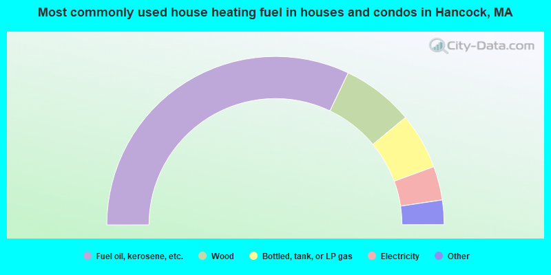
- 64.2%Fuel oil, kerosene, etc.
- 13.8%Wood
- 10.8%Bottled, tank, or LP gas
- 6.5%Electricity
- 3.9%Coal or coke
- 0.9%Other fuel
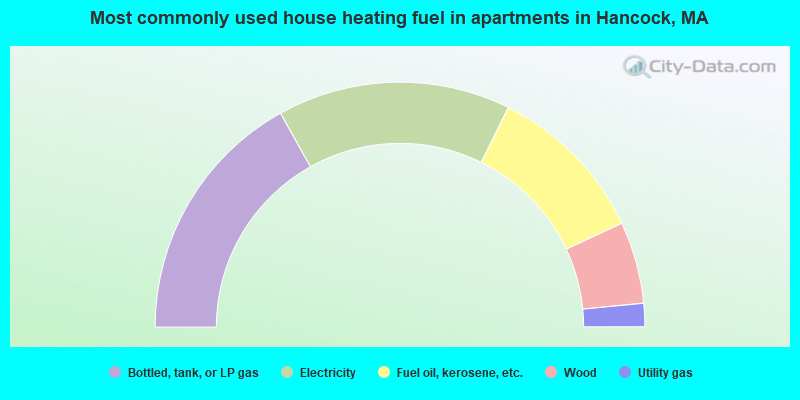
- 33.8%Bottled, tank, or LP gas
- 30.8%Electricity
- 21.5%Fuel oil, kerosene, etc.
- 10.8%Wood
- 3.1%Utility gas
Hancock compared to Massachusetts state average:
- Unemployed percentage below state average.
- Black race population percentage significantly below state average.
- Hispanic race population percentage significantly below state average.
- Median age above state average.
- Foreign-born population percentage significantly below state average.
- Renting percentage below state average.
- Length of stay since moving in significantly above state average.
- Number of rooms per house significantly below state average.
- House age significantly below state average.
- Number of college students below state average.