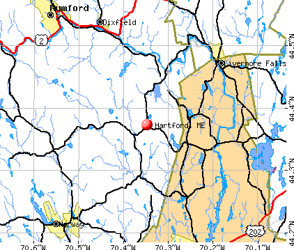
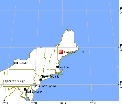
Hartford, Maine
Submit your own pictures of this town and show them to the world
- OSM Map
- General Map
- Google Map
- MSN Map
Population change since 2000: +23.1%
| Males: 599 | |
| Females: 586 |
| Median resident age: | 43.6 years |
| Maine median age: | 43.0 years |
Zip codes: 04221.
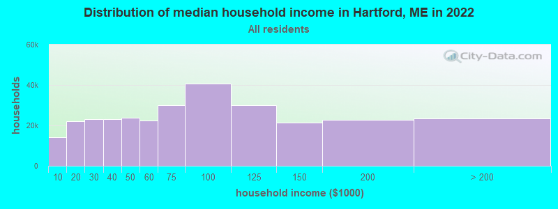
| Hartford: | $60,914 |
| ME: | $69,543 |
Estimated per capita income in 2022: $30,857 (it was $16,326 in 2000)
Hartford town income, earnings, and wages data
Estimated median house or condo value in 2022: $222,162 (it was $85,000 in 2000)
| Hartford: | $222,162 |
| ME: | $290,600 |
Mean prices in 2022: all housing units: $258,607; detached houses: $254,021; townhouses or other attached units: $393,466; in 2-unit structures: $184,786; in 3-to-4-unit structures: $229,715; in 5-or-more-unit structures: $205,553; mobile homes: $333,480; occupied boats, rvs, vans, etc.: $32,243
Detailed information about poverty and poor residents in Hartford, ME
Compare current foreclosures near Hartford, ME:
| Photo | Address | Area | Beds / Baths | Price | Details |
|---|---|---|---|---|---|

|
#1
Trask Rd
Turner, ME 04282
|
- sq. feet
|
3 baths 6 beds |
$149,900
|
show details |

|
#2
Sumner Rd
West Paris, ME 04289
|
936 sq. feet
|
1 baths 2 beds |
show details | |

|
#3
Ridge Rd
Peru, ME 04290
|
1,152 sq. feet
|
1 baths 3 beds |
show details | |

|
#4
Jillson Rd
Greene, ME 04236
|
1,356 sq. feet
|
1 baths 4 beds |
show details | |

|
#5
Cressey Rd
Monmouth, ME 04259
|
2,503 sq. feet
|
2 baths 4 beds |
show details | |

|
#6
Knapp St
Wilton, ME 04294
|
- sq. feet
|
2 baths 4 beds |
show details | |

|
#7
Main St
Lewiston, ME 04240
|
- sq. feet
|
1 baths 3 beds |
show details | |

|
#8
Xivray St
Auburn, ME 04210
|
2,632 sq. feet
|
1 baths - beds |
show details | |

|
#9
Webb River Dr
Dixfield, ME 04224
|
- sq. feet
|
- baths - beds |
show details | |

|
#10
Alpine St Apt 15
Norway, ME 04268
|
- sq. feet
|
- baths - beds |
show details |
| Photo | Address | Area | Beds / Baths | Price | Details |
|---|---|---|---|---|---|

|
#11
Norton Rd
Dixfield, ME 04224
|
- sq. feet
|
- baths - beds |
show details | |

|
#12
Green Woods Rd
Peru, ME 04290
|
- sq. feet
|
- baths - beds |
show details | |

|
#13
Magnum Dr
Turner, ME 04282
|
- sq. feet
|
- baths - beds |
show details | |

|
#14
County Rd
Turner, ME 04282
|
- sq. feet
|
- baths - beds |
show details | |

|
#15
Reservoir Rd
South Paris, ME 04281
|
- sq. feet
|
- baths - beds |
show details | |

|
#16
Front St
Sumner, ME 04292
|
- sq. feet
|
- baths - beds |
show details | |

|
#17
High St
Buckfield, ME 04220
|
- sq. feet
|
- baths - beds |
show details | |

|
#18
Chesterville Rd
Jay, ME 04239
|
- sq. feet
|
- baths - beds |
show details | |

|
Check over 1 million property listings on Foreclosure.com!
|
browse all offers | |||

- 1,13395.6%White alone
- 322.7%Two or more races
- 110.9%American Indian alone
- 60.5%Hispanic
- 10.08%Black alone
- 10.08%Asian alone
- 10.08%Other race alone
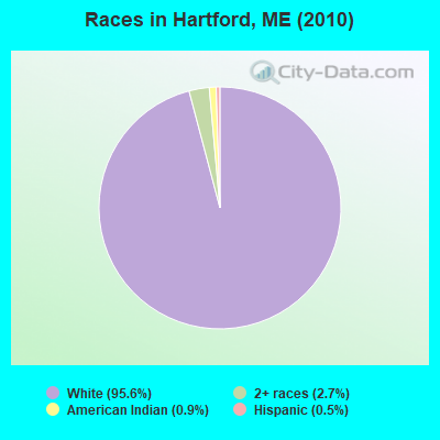
Races in Hartford detailed stats: ancestries, foreign born residents, place of birth
According to our research of Maine and other state lists, there were 4 registered sex offenders living in Hartford, Maine as of April 28, 2024.
The ratio of all residents to sex offenders in Hartford is 296 to 1.
 Recent articles from our blog. Our writers, many of them Ph.D. graduates or candidates, create easy-to-read articles on a wide variety of topics.

 | Well, here goes. The start to our trek North to Maine, our new home-state. (395 replies) |
| Maine Gas Prices (34 replies) |
| Maine weather thread (3207 replies) |
| Augusta ?'s about revitalization (29 replies) |
| Is Southern Maine "Family Friendly"? (90 replies) |
| Freeport/Brunswick Schools? (45 replies) |
Latest news from Hartford, ME collected exclusively by city-data.com from local newspapers, TV, and radio stations
Ancestries: English (21.7%), French (16.6%), Irish (13.4%), French Canadian (10.5%), German (9.1%), United States (8.9%).
Current Local Time: EST time zone
Incorporated on 06/13/1798
Elevation: 460 feet
Land area: 43.9 square miles.
Population density: 27 people per square mile (very low).
8 residents are foreign born
| This town: | 0.8% |
| Maine: | 2.9% |
| Hartford town: | 1.2% ($1,043) |
| Maine: | 1.5% ($1,417) |
Nearest city with pop. 50,000+: Portland, ME  (48.6 miles , pop. 64,249).
Nearest city with pop. 200,000+: Boston, MA (146.9 miles , pop. 589,141).
Nearest city with pop. 1,000,000+: Bronx, NY (303.7 miles , pop. 1,332,650).
Nearest cities:
), ), ), )Latitude: 44.37 N, Longitude: 70.31 W
Area code commonly used in this area: 207

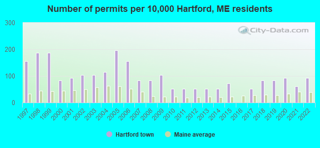
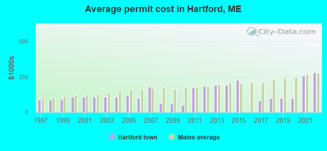
Single-family new house construction building permits:
- 2022: 9 buildings, average cost: $279,200
- 2021: 6 buildings, average cost: $259,200
- 2020: 9 buildings, average cost: $100,000
- 2019: 8 buildings, average cost: $100,000
- 2018: 8 buildings, average cost: $100,000
- 2017: 5 buildings, average cost: $80,000
- 2015: 7 buildings, average cost: $226,800
- 2014: 5 buildings, average cost: $193,300
- 2013: 5 buildings, average cost: $193,300
- 2012: 5 buildings, average cost: $184,000
- 2011: 5 buildings, average cost: $172,800
- 2010: 5 buildings, average cost: $50,000
- 2009: 10 buildings, average cost: $60,000
- 2008: 8 buildings, average cost: $62,500
- 2007: 8 buildings, average cost: $181,200
- 2006: 15 buildings, average cost: $100,000
- 2005: 19 buildings, average cost: $119,000
- 2004: 11 buildings, average cost: $109,200
- 2003: 10 buildings, average cost: $109,200
- 2002: 10 buildings, average cost: $109,200
- 2001: 9 buildings, average cost: $109,200
- 2000: 8 buildings, average cost: $109,200
- 1999: 18 buildings, average cost: $87,400
- 1998: 18 buildings, average cost: $87,400
- 1997: 15 buildings, average cost: $87,400
| Here: | 2.9% |
| Maine: | 3.4% |
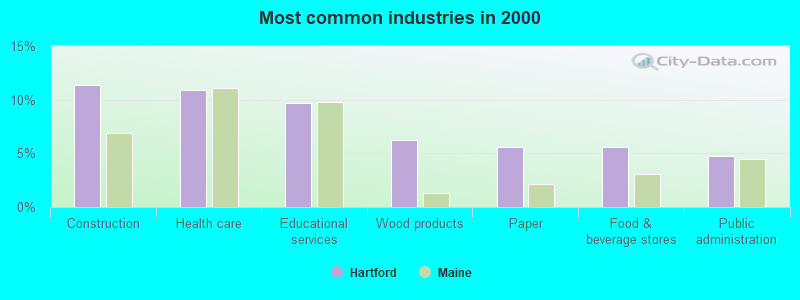
- Construction (11.4%)
- Health care (10.9%)
- Educational services (9.7%)
- Wood products (6.2%)
- Paper (5.6%)
- Food & beverage stores (5.6%)
- Public administration (4.7%)
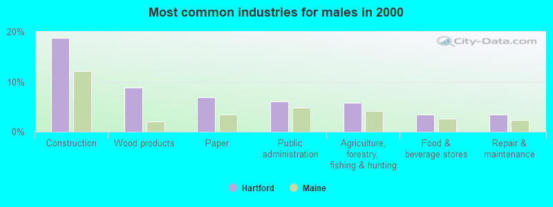
- Construction (18.7%)
- Wood products (8.8%)
- Paper (6.9%)
- Public administration (6.1%)
- Agriculture, forestry, fishing & hunting (5.7%)
- Food & beverage stores (3.4%)
- Repair & maintenance (3.4%)
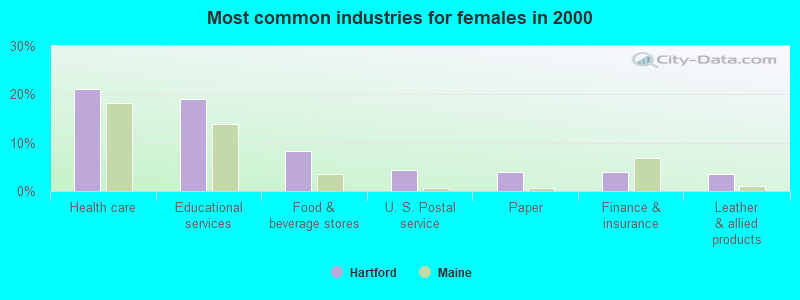
- Health care (21.1%)
- Educational services (19.1%)
- Food & beverage stores (8.3%)
- U. S. Postal service (4.4%)
- Paper (3.9%)
- Finance & insurance (3.9%)
- Leather & allied products (3.4%)
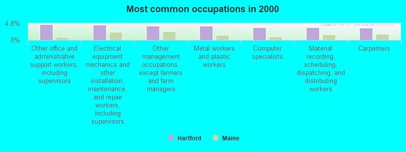
- Other office and administrative support workers, including supervisors (4.5%)
- Electrical equipment mechanics and other installation, maintenance, and repair workers, including supervisors (4.3%)
- Other management occupations, except farmers and farm managers (4.1%)
- Metal workers and plastic workers (4.1%)
- Computer specialists (3.6%)
- Material recording, scheduling, dispatching, and distributing workers (3.6%)
- Carpenters (3.4%)
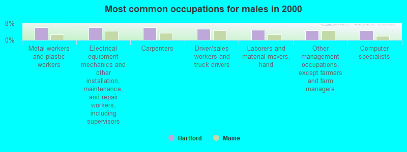
- Metal workers and plastic workers (6.1%)
- Electrical equipment mechanics and other installation, maintenance, and repair workers, including supervisors (6.1%)
- Carpenters (6.1%)
- Driver/sales workers and truck drivers (5.3%)
- Laborers and material movers, hand (5.0%)
- Other management occupations, except farmers and farm managers (4.6%)
- Computer specialists (4.6%)

- Registered nurses (7.4%)
- Material recording, scheduling, dispatching, and distributing workers (6.4%)
- Other office and administrative support workers, including supervisors (6.4%)
- Nursing, psychiatric, and home health aides (5.4%)
- Cooks and food preparation workers (5.4%)
- Other teachers, instructors, education, training, and library occupations (4.9%)
- Information and record clerks, except customer service representatives (4.4%)
Average climate in Hartford, Maine
Based on data reported by over 4,000 weather stations


(lower is better)
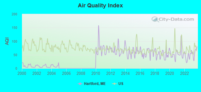
Air Quality Index (AQI) level in 2023 was 57.2. This is better than average.
| City: | 57.2 |
| U.S.: | 72.6 |
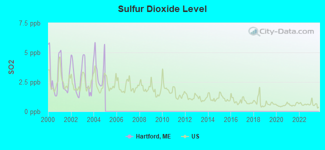
Sulfur Dioxide (SO2) [ppb] level in 2004 was 3.52. This is significantly worse than average. Closest monitor was 7.6 miles away from the city center.
| City: | 3.52 |
| U.S.: | 1.51 |
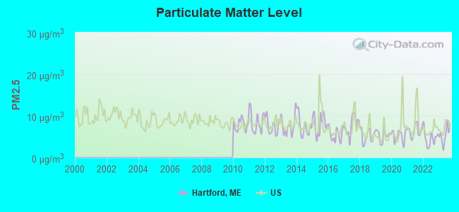
Particulate Matter (PM2.5) [µg/m3] level in 2023 was 5.52. This is significantly better than average. Closest monitor was 17.4 miles away from the city center.
| City: | 5.52 |
| U.S.: | 8.11 |
Earthquake activity:
Hartford-area historical earthquake activity is significantly above Maine state average. It is 75% smaller than the overall U.S. average.On 4/20/2002 at 10:50:47, a magnitude 5.3 (5.3 ML, Depth: 3.0 mi, Class: Moderate, Intensity: VI - VII) earthquake occurred 167.8 miles away from the city center
On 10/16/2012 at 23:12:25, a magnitude 4.7 (4.7 ML, Depth: 10.0 mi, Class: Light, Intensity: IV - V) earthquake occurred 56.0 miles away from Hartford center
On 4/20/2002 at 10:50:47, a magnitude 5.2 (5.2 MB, 4.2 MS, 5.2 MW, 5.0 MW) earthquake occurred 168.8 miles away from the city center
On 10/7/1983 at 10:18:46, a magnitude 5.3 (5.1 MB, 5.3 LG, 5.1 ML) earthquake occurred 202.3 miles away from Hartford center
On 1/19/1982 at 00:14:42, a magnitude 4.7 (4.5 MB, 4.7 MD, 4.5 LG) earthquake occurred 88.0 miles away from the city center
On 2/26/1999 at 03:38:43, a magnitude 3.8 (3.8 LG, Depth: 2.0 mi, Class: Light, Intensity: II - III) earthquake occurred 39.6 miles away from Hartford center
Magnitude types: regional Lg-wave magnitude (LG), body-wave magnitude (MB), duration magnitude (MD), local magnitude (ML), surface-wave magnitude (MS), moment magnitude (MW)
Natural disasters:
The number of natural disasters in Oxford County (31) is a lot greater than the US average (15).Major Disasters (Presidential) Declared: 23
Emergencies Declared: 7
Causes of natural disasters: Floods: 19, Storms: 16, Snows: 7, Hurricanes: 3, Heavy Rains: 2, Blizzard: 1, Ice Storm: 1, Landslide: 1, Mudslide: 1, Snowfall: 1, Tropical Storm: 1, Wind: 1, Winter Storm: 1, Other: 2 (Note: some incidents may be assigned to more than one category).
Hospitals and medical centers near Hartford:
- VICTORIAN VILLA NURSING HOME (Nursing Home, about 6 miles away; CANTON, ME)
- LEDGEVIEW LIVING CENTER (Nursing Home, about 13 miles away; WEST PARIS, ME)
- MAINE VETERANS HOME - SO PARIS (Nursing Home, about 14 miles away; SOUTH PARIS, ME)
- DIXFIELD HEALTH CARE CENTER (Nursing Home, about 15 miles away; DIXFIELD, ME)
- NORWAY REHAB AND LIVING CENTER (Nursing Home, about 16 miles away; NORWAY, ME)
located in Hartford:
Colleges/universities with over 2000 students nearest to Hartford:
- University of Maine at Farmington (about 23 miles; Farmington, ME; Full-time enrollment: 2,036)
- University of Maine at Augusta (about 26 miles; Augusta, ME; FT enrollment: 3,204)
- Saint Joseph's College of Maine (about 39 miles; Standish, ME; FT enrollment: 2,010)
- University of Southern Maine (about 49 miles; Portland, ME; FT enrollment: 6,647)
- Southern Maine Community College (about 50 miles; South Portland, ME; FT enrollment: 4,666)
- University of New England (about 63 miles; Biddeford, ME; FT enrollment: 4,539)
- Plymouth State University (about 81 miles; Plymouth, NH; FT enrollment: 4,838)
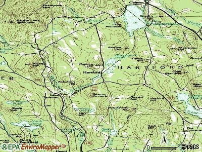
Points of interest:
Church in Hartford: Hartford Community Church (A). Display/hide its location on the map
Cemeteries: Poland Corner Cemetery (1), Maple Grove Cemetery (2), Meetinghouse Hill Cemetery (3), Bear Mountain Cemetery (4), Hartford Center Cemetery (5), Parsons Cemetery (6), Howard Cemetery (7). Display/hide their locations on the map
Lakes and reservoirs: Lake Anasagunticook (A), Bunganock Pond (B), Little Bear Pond (C), Northeast Pond (D), Swan Pond (E), Lake Anasagunticook (F). Display/hide their locations on the map
Streams, rivers, and creeks: Sparrow Brook (A), Thompson Brook (B), Russell Brook (C), Mitchell Brook (D), Hayford Brook (E), Bunganock Brook (F), Bog Brook (G). Display/hide their locations on the map
Drinking water stations with addresses in Hartford and their reported violations in the past:
THE LANDMARK RESTAURANT (Population served: 770, Groundwater):Past health violations:SPINSFIELD COMMONS (Population served: 105, Groundwater):Past monitoring violations:
- MCL, Acute (TCR) - Between OCT-2006 and DEC-2006, Contaminant: Coliform. Follow-up actions: St Boil Water Order (NOV-03-2006), St Violation/Reminder Notice (NOV-03-2006), St Public Notif requested (NOV-03-2006), St Tech Assistance Visit (NOV-03-2006), St Public Notif received (NOV-15-2006), St Compliance achieved (AUG-29-2008)
- MCL, Monthly (TCR) - In OCT-2005, Contaminant: Coliform. Follow-up actions: St Public Notif requested (NOV-07-2005), St Violation/Reminder Notice (NOV-07-2005), St Public Notif received (2 times from NOV-23-2005 to NOV-23-2005), St Compliance achieved (JAN-29-2007)
- 13 routine major monitoring violations
Past health violations:CANTON POINT PARK (Population served: 73, Groundwater):Past monitoring violations:
- MCL, Monthly (TCR) - In AUG-2012, Contaminant: Coliform. Follow-up actions: St Public Notif requested (SEP-04-2012), St Formal NOV issued (SEP-04-2012), St Public Notif received (DEC-12-2012), St Compliance achieved (FEB-27-2013)
- MCL, Monthly (TCR) - In JUL-2012, Contaminant: Coliform. Follow-up actions: St Public Notif requested (AUG-06-2012), St Formal NOV issued (AUG-06-2012), St Public Notif received (DEC-12-2012), St Compliance achieved (FEB-27-2013)
- MCL, Average - Between JUL-2010 and SEP-2010, Contaminant: Arsenic. Follow-up actions: St Public Notif requested (DEC-20-2010), St Formal NOV issued (DEC-20-2010), St Compliance achieved (MAY-24-2011), St Public Notif received (FEB-07-2012)
- MCL, Average - Between APR-2010 and JUN-2010, Contaminant: Arsenic. Follow-up actions: St Public Notif requested (DEC-20-2010), St Formal NOV issued (DEC-20-2010), St Compliance achieved (MAY-24-2011), St Public Notif received (FEB-07-2012)
- MCL, Average - Between JAN-2010 and MAR-2010, Contaminant: Arsenic. Follow-up actions: St Public Notif requested (AUG-19-2010), St Formal NOV issued (AUG-19-2010), St Compliance achieved (MAY-24-2011), St Public Notif received (FEB-07-2012)
- MCL, Average - Between OCT-2009 and DEC-2009, Contaminant: Arsenic. Follow-up actions: St Public Notif requested (JAN-08-2010), St Formal NOV issued (JAN-08-2010), St Public Notif received (NOV-02-2010), St Compliance achieved (MAY-24-2011)
- Monitoring, Repeat Major (TCR) - In NOV-2012, Contaminant: Coliform (TCR). Follow-up actions: St Public Notif requested (DEC-21-2012), St Formal NOV issued (DEC-21-2012), St Public Notif received (APR-02-2013), St Compliance achieved (MAY-29-2013)
- Monitoring, Repeat Major (TCR) - In SEP-2012, Contaminant: Coliform (TCR). Follow-up actions: St Public Notif requested (NOV-01-2012), St Formal NOV issued (NOV-01-2012), St Public Notif received (DEC-12-2012), St Compliance achieved (FEB-27-2013)
- Follow-up Or Routine LCR Tap M/R - In OCT-01-2011, Contaminant: Lead and Copper Rule. Follow-up actions: St Public Notif requested (JAN-18-2012), St Formal NOV issued (JAN-18-2012), St Public Notif received (JUL-20-2012), St Compliance achieved (SEP-21-2012)
- Follow-up Or Routine LCR Tap M/R - In OCT-01-2010, Contaminant: Lead and Copper Rule. Follow-up actions: St Public Notif requested (NOV-16-2010), St Formal NOV issued (NOV-16-2010), St Compliance achieved (FEB-27-2013)
- 7 routine major monitoring violations
- 41 regular monitoring violations
Past health violations:Past monitoring violations:
- MCL, Average - Between OCT-2012 and DEC-2012, Contaminant: Gross Alpha, Excl. Radon and U. Follow-up actions: St Public Notif requested (DEC-06-2012), St Formal NOV issued (DEC-06-2012), St Public Notif received (APR-02-2013), St Compliance achieved (NOV-26-2013)
- MCL, Average - Between JUL-2012 and SEP-2012, Contaminant: Gross Alpha, Excl. Radon and U. Follow-up actions: St Public Notif requested (NOV-15-2012), St Formal NOV issued (NOV-15-2012), St Public Notif received (APR-02-2013), St Compliance achieved (NOV-26-2013)
- MCL, Average - Between APR-2012 and JUN-2012, Contaminant: Gross Alpha, Excl. Radon and U. Follow-up actions: St Public Notif received (AUG-03-2012), St Public Notif requested (NOV-05-2012), St Formal NOV issued (NOV-05-2012), St Public Notif received (APR-02-2013), St Compliance achieved (NOV-26-2013)
- MCL, Average - Between JAN-2012 and MAR-2012, Contaminant: Gross Alpha, Excl. Radon and U. Follow-up actions: St Public Notif requested (NOV-05-2012), St Formal NOV issued (NOV-05-2012), St Public Notif received (APR-02-2013), St Compliance achieved (NOV-26-2013)
- MCL, Average - Between OCT-2011 and DEC-2011, Contaminant: Gross Alpha, Excl. Radon and U. Follow-up actions: St Public Notif requested (NOV-05-2012), St Formal NOV issued (NOV-05-2012), St Public Notif received (APR-02-2013), St Compliance achieved (NOV-26-2013)
- MCL, Average - Between JUL-2011 and SEP-2011, Contaminant: Gross Alpha, Excl. Radon and U. Follow-up actions: St Public Notif requested (NOV-03-2011), St Formal NOV issued (NOV-03-2011), St Public Notif received (FEB-07-2012), St Compliance achieved (NOV-26-2013)
- MCL, Monthly (TCR) - Between JUL-2009 and SEP-2009, Contaminant: Coliform. Follow-up actions: St Public Notif requested (OCT-26-2009), St Formal NOV issued (OCT-26-2009), St Compliance achieved (SEP-08-2011), St Intentional no-action (SEP-09-2011)
- Monitoring, Source Water (GWR) - In OCT-2012, Contaminant: E. COLI. Follow-up actions: St Public Notif requested (NOV-28-2012), St Formal NOV issued (NOV-28-2012), St Public Notif received (APR-02-2013), St Compliance achieved (MAR-28-2014)
- Monitoring, Repeat Major (TCR) - In OCT-2012, Contaminant: Coliform (TCR). Follow-up actions: St Compliance achieved (NOV-14-2012), St Public Notif requested (DEC-04-2012), St Formal NOV issued (DEC-04-2012), St Public Notif received (DEC-12-2012)
- Monitoring, Repeat Major (TCR) - Between JUL-2012 and SEP-2012, Contaminant: Coliform (TCR). Follow-up actions: St Public Notif requested (NOV-09-2012), St Formal NOV issued (NOV-09-2012), St Compliance achieved (NOV-14-2012), St Public Notif received (DEC-12-2012)
- 2 routine major monitoring violations
- 2 regular monitoring violations
| This town: | 2.5 people |
| Maine: | 2.3 people |
| This town: | 69.5% |
| Whole state: | 62.9% |
| This town: | 10.4% |
| Whole state: | 9.4% |
Likely homosexual households (counted as self-reported same-sex unmarried-partner households)
- Lesbian couples: 1.0% of all households
- Gay men: 0.0% of all households
| This town: | 12.7% |
| Whole state: | 10.9% |
| This town: | 6.3% |
| Whole state: | 4.1% |
For population 15 years and over in Hartford:
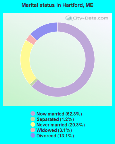
- Never married: 20.3%
- Now married: 62.3%
- Separated: 1.2%
- Widowed: 3.1%
- Divorced: 13.1%
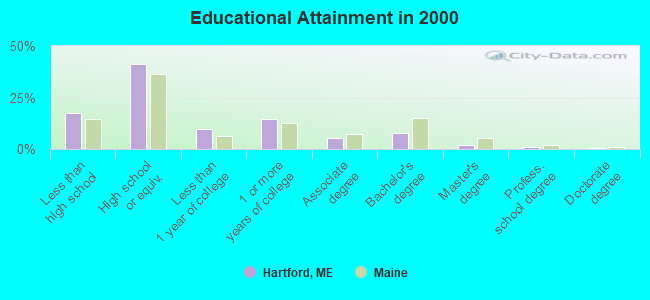
For population 25 years and over in Hartford:
- High school or higher: 82.5%
- Bachelor's degree or higher: 11.2%
- Graduate or professional degree: 3.4%
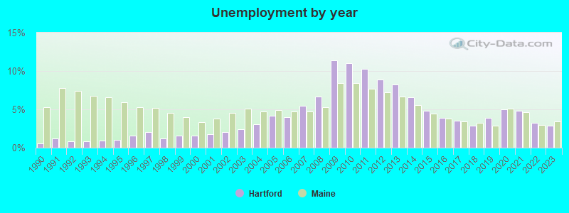
- Unemployed: 4.9%
- Mean travel time to work (commute): 35.8 minutes
| Here: | 9.6 |
| Maine average: | 11.2 |
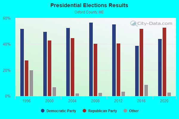
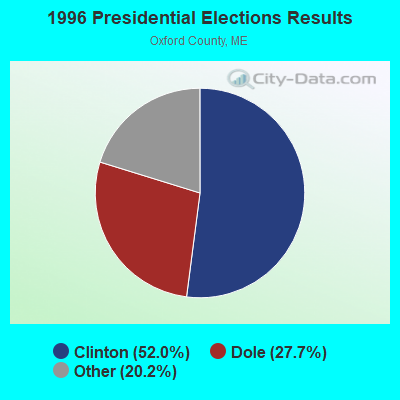
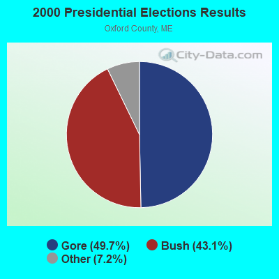
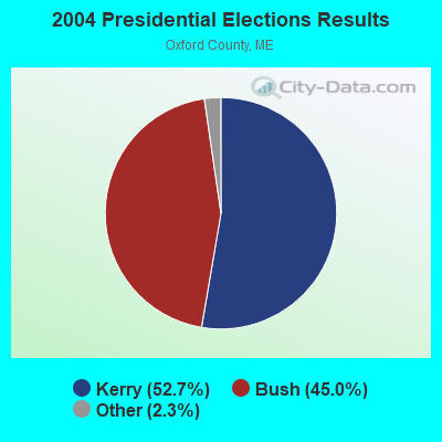


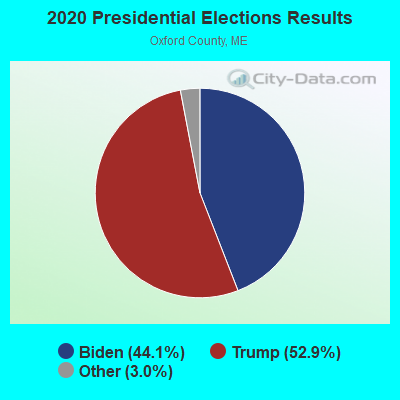
Graphs represent county-level data. Detailed 2008 Election Results
Religion statistics for Hartford, ME (based on Oxford County data)
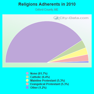
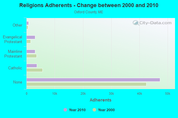
| Religion | Adherents | Congregations |
|---|---|---|
| Catholic | 3,708 | 7 |
| Mainline Protestant | 3,085 | 45 |
| Evangelical Protestant | 3,045 | 37 |
| Other | 719 | 14 |
| None | 47,276 | - |
Food Environment Statistics:
| Oxford County: | 2.47 / 10,000 pop. |
| Maine: | 2.80 / 10,000 pop. |
| This county: | 0.35 / 10,000 pop. |
| Maine: | 0.14 / 10,000 pop. |
| This county: | 2.29 / 10,000 pop. |
| Maine: | 2.20 / 10,000 pop. |
| Oxford County: | 7.94 / 10,000 pop. |
| State: | 5.75 / 10,000 pop. |
| Oxford County: | 9.35 / 10,000 pop. |
| Maine: | 11.02 / 10,000 pop. |
| Here: | 7.6% |
| Maine: | 8.2% |
| Here: | 25.6% |
| Maine: | 25.0% |
Strongest AM radio stations in Hartford:
- WTME (780 AM; 10 kW; RUMFORD, ME; Owner: MOUNTAIN VALLEY BROADCASTING, INC.)
- WLAM (1470 AM; 5 kW; LEWISTON, ME; Owner: RADIO PARTNERS OF MAINE, L.P.)
- WFAU (1280 AM; 5 kW; GARDINER, ME; Owner: CAPSTAR TX LIMITED PARTNERSHIP)
- WSKW (1160 AM; 10 kW; SKOWHEGAN, ME; Owner: MOUNTAIN WIRELESS, INCORPORATED)
- WMTW (870 AM; 10 kW; GORHAM, ME; Owner: RADIO PARTNERS OF MAINE, L.P.)
- WGAN (560 AM; 5 kW; PORTLAND, ME; Owner: SAGA COMMUNICATIONS OF NEW ENGLAND, LLC)
- WRKO (680 AM; 50 kW; BOSTON, MA; Owner: ENTERCOM BOSTON LICENSE, LLC)
- WKTQ (1450 AM; 1 kW; SOUTH PARIS, ME; Owner: PENNESSEEWASSEE BROADCASTING CO INC.)
- WCNM (1240 AM; 1 kW; LEWISTON, ME; Owner: CHRISTIAN FAMILY RADIO, INC.)
- WEEI (850 AM; 50 kW; BOSTON, MA; Owner: ENTERCOM BOSTON LICENSE, LLC)
- WBZ (1030 AM; 50 kW; BOSTON, MA; Owner: INFINITY BROADCASTING OPERATIONS, INC.)
- WCRN (830 AM; 50 kW; WORCESTER, MA; Owner: CARTER BROADCASTING CORPORATION)
- WNNZ (640 AM; 50 kW; WESTFIELD, MA; Owner: CLEAR CHANNEL BROADCASTING LICENSES, INC.)
Strongest FM radio stations in Hartford:
- WLOB-FM (96.3 FM; RUMFORD, ME; Owner: ATLANTIC COAST RADIO, LLC)
- WPKQ (103.7 FM; NORTH CONWAY, NH; Owner: CITADEL BROADCASTING COMPANY)
- WTBM (100.7 FM; MEXICO, ME; Owner: MOUNTAIN VALLEY BROADCASTING, INC.)
- WHOM (94.9 FM; MT. WASHINGTON, NH; Owner: CITADEL BROADCASTING COMPANY)
- WTOS-FM (105.1 FM; SKOWHEGAN, ME; Owner: CAPSTAR TX LIMITED PARTNERSHIP)
- WBLM (102.9 FM; PORTLAND, ME; Owner: CITADEL BROADCASTING COMPANY)
- WMEA (90.1 FM; PORTLAND, ME; Owner: MAINE PUBLIC BROADCASTING CORPORATION)
- WCYI (93.9 FM; LEWISTON, ME; Owner: CITADEL BROADCASTING COMPANY)
- WTHT (107.5 FM; LEWISTON, ME; Owner: RADIO PARTNERS OF MAINE, L.P.)
- WOXO-FM (92.7 FM; NORWAY, ME; Owner: TRI-COUNTY BROADCASTING, INC.)
- WJBQ (97.9 FM; PORTLAND, ME; Owner: CITADEL BROADCASTING COMPANY)
- WMEK-FM (99.9 FM; AUBURN, ME; Owner: RADIO PARTNERS OF MAINE, L.P.)
- WKTJ-FM (99.3 FM; FARMINGTON, ME; Owner: FRANKLIN BROADCASTING CORPORATION)
- WWWA (95.3 FM; WINSLOW, ME; Owner: LIGHT OF LIFE MINISTRIES, INC.)
- WBCI (105.9 FM; BATH, ME; Owner: BLOUNT COMMUNICATIONS, INC.)
- WABK-FM (104.3 FM; GARDINER, ME; Owner: CAPSTAR TX LIMITED PARTNERSHIP)
- WMME-FM (92.3 FM; AUGUSTA, ME; Owner: CITADEL BROADCASTING COMPANY)
- WKCG (101.3 FM; AUGUSTA, ME; Owner: CAPSTAR TX LIMITED PARTNERSHIP)
TV broadcast stations around Hartford:
- WGME-TV (Channel 13; PORTLAND, ME; Owner: WGME LICENSEE, LLC)
- WPFO (Channel 23; WATERVILLE, ME; Owner: CMCG PORTLAND LICENSE LLC)
- WMTW-TV (Channel 8; POLAND SPRING, ME; Owner: WMTW BROADCAST GROUP, LLC)
- WCBB (Channel 10; AUGUSTA, ME; Owner: MAINE PUBLIC BROADCASTING CORP.)
- WCSH (Channel 6; PORTLAND, ME; Owner: PACIFIC AND SOUTHERN COMPANY, INC.)
- WPXT (Channel 51; PORTLAND, ME; Owner: HMW, INC.)
- WPME (Channel 35; LEWISTON, ME; Owner: KB PRIME MEDIA LLC)
- W21BI (Channel 21; FARMINGTON, ME; Owner: TRINITY BROADCASTING NETWORK)
- National Bridge Inventory (NBI) Statistics
- 1Number of bridges
- 3ft / 1.4mTotal length
- 1,589Total average daily traffic
- 79Total average daily truck traffic
- 2,384Total future (year 2036) average daily traffic
FCC Registered Amateur Radio Licenses:
6- Call Sign: N1OXC, Licensee ID: L00811614, Grant Date: 05/14/2014, Expiration Date: 05/14/2024, Registrant: Peter A Theriault, Rr #1 Box 330, Hartford, ME 04221
- Call Sign: N1PDQ, Licensee ID: L00811624, Grant Date: 02/12/2004, Expiration Date: 02/12/2014, Cancellation Date: 02/13/2016, Registrant: Christine L Theriault, Rr 1 Box 330, Hartford, ME 04221
- Call Sign: W1CFJ, Licensee ID: L00955160, Grant Date: 01/21/2015, Expiration Date: 03/20/2025, Certifier: William C Ricker, Registrant: William C Ricker, 1661 Main St, Hartford, ME 04220
- Call Sign: KJ6JBA, Licensee ID: L01577709, Grant Date: 04/21/2020, Expiration Date: 06/21/2030, Certifier: Sarah Courchene, Registrant: Sarah C Eller, 119 Cary Hill Rd., Hartford, ME 04002
- Call Sign: KC3AHA, Licensee ID: L01776438, Grant Date: 03/19/2024, Expiration Date: 03/19/2034, Certifier: Patton Y Laverty, Registrant: Patton Y Laverty, 130 Desert Way, Hartford, ME 04220
- Call Sign: KC1PEC, Licensee ID: L02443405, Grant Date: 04/26/2021, Expiration Date: 04/26/2031, Certifier: Gabriel D Laverty, Registrant: Gabriel D Laverty, 130 Desert Way, Hartford, ME 04220
FAA Registered Aircraft:
3- Aircraft: FROST PETER R HIMAX 1700 (Category: Land, Weight: Up to 12,499 Pounds), Engine: AMA/EXPR UNKNOWN ENG (Reciprocating)
N-Number: 2450F, N2450F, N-2450F, Serial Number: 1, Year manufactured: 2005, Airworthiness Date: 11/01/2005, Certificate Issue Date: 06/11/2015
Registrant (Individual): Peter R Frost, 47 West Cove Dr, Hartford, ME 04220 - Aircraft: CESSNA 182K (Category: Land, Seats: 4, Weight: Up to 12,499 Pounds, Speed: 119 mph), Engine: CONT MOTOR O-470 SERIES (230 HP) (Reciprocating)
N-Number: 3153Q, N3153Q, N-3153Q, Serial Number: 18258153, Year manufactured: 1967, Airworthiness Date: 04/25/1967, Certificate Issue Date: 02/20/2004
Registrant (Corporation): Maine Mold & Machine Inc, 208 Town Farm Rd, Hartford, ME 04220 - Aircraft: CESSNA 401A (Category: Land, Engines: 2, Seats: 8, Weight: Up to 12,499 Pounds, Speed: 198 mph), Engine: Reciprocating
N-Number: 70SC, N70SC, N-70SC, Serial Number: 401A-0032, Airworthiness Date: 06/28/1982, Certificate Issue Date: 10/14/2015
Registrant (Corporation): Maine Mold & Machine Inc, 208 Town Farm Rd, Hartford, ME 04220
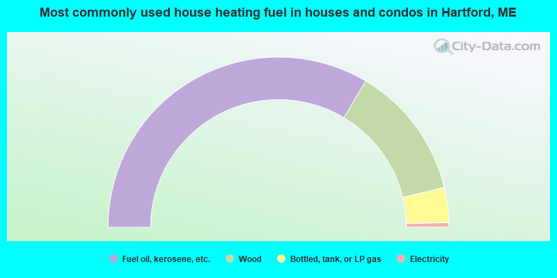
- 67.2%Fuel oil, kerosene, etc.
- 25.4%Wood
- 6.6%Bottled, tank, or LP gas
- 0.9%Electricity
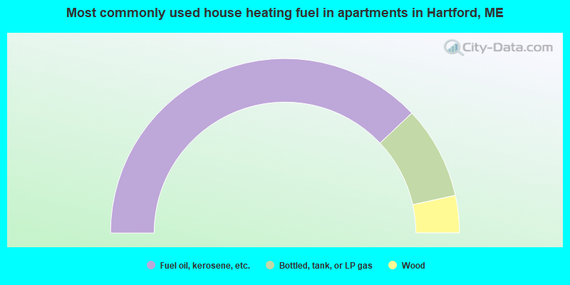
- 75.9%Fuel oil, kerosene, etc.
- 17.2%Bottled, tank, or LP gas
- 6.9%Wood
Hartford compared to Maine state average:
- Unemployed percentage below state average.
- Black race population percentage significantly below state average.
- Hispanic race population percentage significantly below state average.
- Foreign-born population percentage significantly below state average.
- Renting percentage significantly below state average.
- Length of stay since moving in significantly above state average.
- Number of rooms per house significantly below state average.
- House age significantly below state average.
- Number of college students below state average.
- Percentage of population with a bachelor's degree or higher significantly below state average.

|
Total of 9 patent applications in 2008-2024.