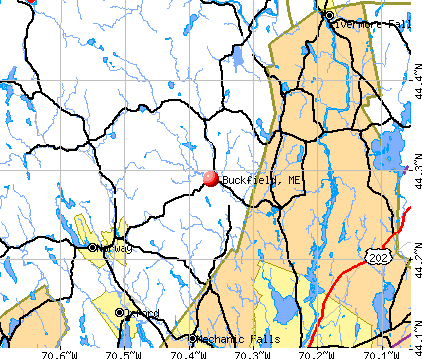
Buckfield, Maine

Submit your own pictures of this town and show them to the world
- OSM Map
- General Map
- Google Map
- MSN Map
Population change since 2000: +16.6%
 |
| Males: 1,024 | |
| Females: 985 |
| Median resident age: | 41.2 years |
| Maine median age: | 43.0 years |
Zip codes: 04220.
| Buckfield: | $61,470 |
| ME: | $69,543 |
Estimated per capita income in 2022: $33,082 (it was $17,503 in 2000)
Buckfield town income, earnings, and wages data
Estimated median house or condo value in 2022: $210,923 (it was $80,700 in 2000)
| Buckfield: | $210,923 |
| ME: | $290,600 |
Mean prices in 2022: all housing units: $258,607; detached houses: $254,021; townhouses or other attached units: $393,466; in 2-unit structures: $184,786; in 3-to-4-unit structures: $229,715; in 5-or-more-unit structures: $205,553; mobile homes: $333,480; occupied boats, rvs, vans, etc.: $32,243
Detailed information about poverty and poor residents in Buckfield, ME


- 1,95497.3%White alone
- 261.3%Two or more races
- 110.5%Hispanic
- 80.4%Asian alone
- 40.2%Black alone
- 50.2%American Indian alone
- 10.05%Other race alone
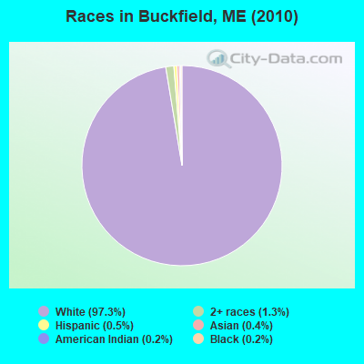
Races in Buckfield detailed stats: ancestries, foreign born residents, place of birth
According to our research of Maine and other state lists, there were 2 registered sex offenders living in Buckfield, Maine as of April 27, 2024.
The ratio of all residents to sex offenders in Buckfield is 1,005 to 1.
The ratio of registered sex offenders to all residents in this city is lower than the state average.
 Recent articles from our blog. Our writers, many of them Ph.D. graduates or candidates, create easy-to-read articles on a wide variety of topics.

 | upstate NY vs Maine (14 replies) |
| Maine's Off-Topic Thread: Part Nine (389 replies) |
| Rural property close to water, less than $50k? (19 replies) |
| Maine's Own Off-Topic Thread - Pt. 3 (2000 replies) |
| still truckin', 60's hippies moving to Maine (93 replies) |
| Photos of Maine (4586 replies) |
Latest news from Buckfield, ME collected exclusively by city-data.com from local newspapers, TV, and radio stations
Ancestries: English (27.5%), Irish (11.6%), French (11.3%), German (9.3%), United States (9.1%), French Canadian (5.5%).
Current Local Time: EST time zone
Incorporated on 03/16/1793
Elevation: 400 feet
Land area: 37.7 square miles.
Population density: 53 people per square mile (very low).
19 residents are foreign born
| This town: | 1.1% |
| Maine: | 2.9% |
| Buckfield town: | 1.6% ($1,270) |
| Maine: | 1.5% ($1,417) |
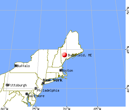
Nearest city with pop. 50,000+: Portland, ME  (43.9 miles , pop. 64,249).
Nearest city with pop. 200,000+: Boston, MA (141.3 miles , pop. 589,141).
Nearest city with pop. 1,000,000+: Bronx, NY (297.9 miles , pop. 1,332,650).
Nearest cities:
), ), ), ), Latitude: 44.30 N, Longitude: 70.37 W
Area code: 207

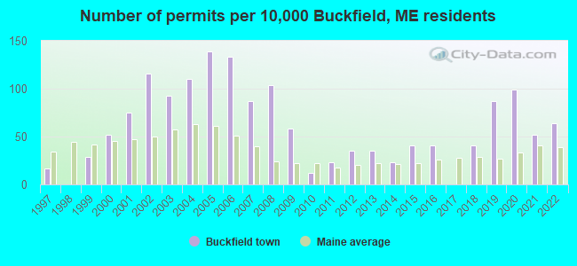
Single-family new house construction building permits:
- 2022: 11 buildings, average cost: $265,500
- 2021: 9 buildings, average cost: $259,200
- 2020: 17 buildings, average cost: $282,200
- 2019: 15 buildings, average cost: $282,200
- 2018: 7 buildings, average cost: $249,800
- 2016: 7 buildings, average cost: $226,800
- 2015: 7 buildings, average cost: $226,800
- 2014: 4 buildings, average cost: $97,900
- 2013: 6 buildings, average cost: $193,300
- 2012: 6 buildings, average cost: $20,800
- 2011: 4 buildings, average cost: $150,000
- 2010: 2 buildings, average cost: $100,000
- 2009: 10 buildings, average cost: $127,000
- 2008: 18 buildings, average cost: $150,000
- 2007: 15 buildings, average cost: $155,000
- 2006: 23 buildings, average cost: $170,000
- 2005: 24 buildings, average cost: $72,500
- 2004: 19 buildings, average cost: $92,500
- 2003: 16 buildings, average cost: $95,400
- 2002: 20 buildings, average cost: $82,400
- 2001: 13 buildings, average cost: $73,700
- 2000: 9 buildings, average cost: $84,900
- 1999: 5 buildings, average cost: $109,200
- 1997: 3 buildings, average cost: $91,700

| Here: | 3.7% |
| Maine: | 3.4% |
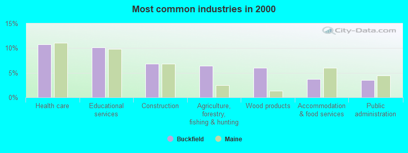
- Health care (10.7%)
- Educational services (10.2%)
- Construction (6.8%)
- Agriculture, forestry, fishing & hunting (6.4%)
- Wood products (6.0%)
- Accommodation & food services (3.7%)
- Public administration (3.5%)
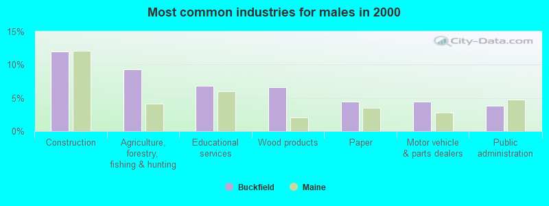
- Construction (12.0%)
- Agriculture, forestry, fishing & hunting (9.3%)
- Educational services (6.8%)
- Wood products (6.6%)
- Paper (4.5%)
- Motor vehicle & parts dealers (4.5%)
- Public administration (3.9%)
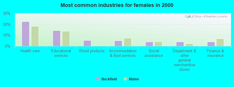
- Health care (22.5%)
- Educational services (14.3%)
- Wood products (5.4%)
- Accommodation & food services (5.2%)
- Social assistance (4.0%)
- Department & other general merchandise stores (4.0%)
- Finance & insurance (4.0%)

- Metal workers and plastic workers (5.5%)
- Nursing, psychiatric, and home health aides (4.8%)
- Other production occupations, including supervisors (4.6%)
- Electrical equipment mechanics and other installation, maintenance, and repair workers, including supervisors (4.6%)
- Laborers and material movers, hand (3.9%)
- Driver/sales workers and truck drivers (3.6%)
- Other management occupations, except farmers and farm managers (3.5%)
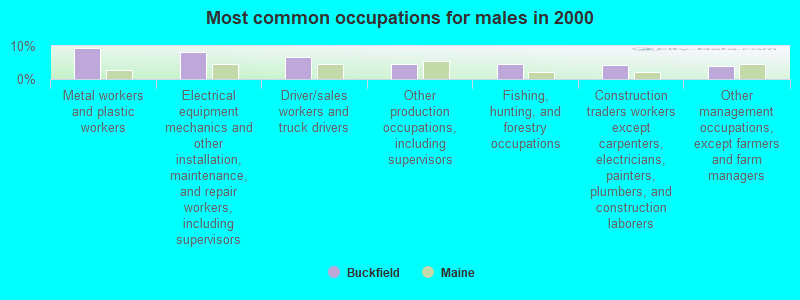
- Metal workers and plastic workers (9.3%)
- Electrical equipment mechanics and other installation, maintenance, and repair workers, including supervisors (8.3%)
- Driver/sales workers and truck drivers (6.6%)
- Other production occupations, including supervisors (4.7%)
- Fishing, hunting, and forestry occupations (4.5%)
- Construction traders workers except carpenters, electricians, painters, plumbers, and construction laborers (4.3%)
- Other management occupations, except farmers and farm managers (4.1%)

- Nursing, psychiatric, and home health aides (9.4%)
- Other office and administrative support workers, including supervisors (5.9%)
- Preschool, kindergarten, elementary, and middle school teachers (5.2%)
- Other sales and related occupations, including supervisors (4.9%)
- Secretaries and administrative assistants (4.7%)
- Other production occupations, including supervisors (4.4%)
- Registered nurses (4.4%)
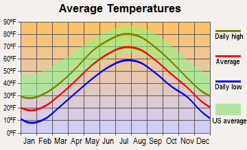
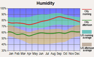
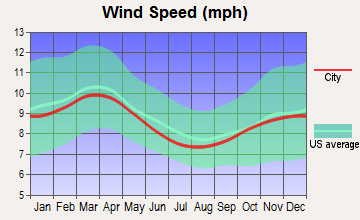
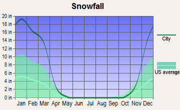
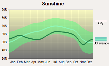
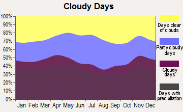
Average climate in Buckfield, Maine
Based on data reported by over 4,000 weather stations
(lower is better)
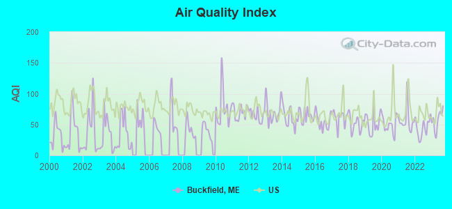
Air Quality Index (AQI) level in 2023 was 57.2. This is better than average.
| City: | 57.2 |
| U.S.: | 72.6 |
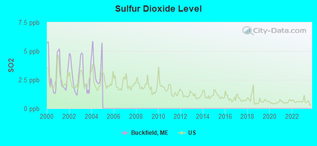
Sulfur Dioxide (SO2) [ppb] level in 2004 was 3.52. This is significantly worse than average. Closest monitor was 13.4 miles away from the city center.
| City: | 3.52 |
| U.S.: | 1.51 |
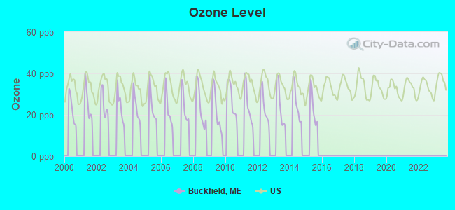
Ozone [ppb] level in 2014 was 25.8. This is better than average. Closest monitor was 13.4 miles away from the city center.
| City: | 25.8 |
| U.S.: | 33.3 |
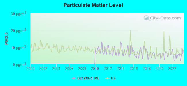
Particulate Matter (PM2.5) [µg/m3] level in 2023 was 5.52. This is significantly better than average. Closest monitor was 16.1 miles away from the city center.
| City: | 5.52 |
| U.S.: | 8.11 |
Earthquake activity:
Buckfield-area historical earthquake activity is significantly above Maine state average. It is 75% smaller than the overall U.S. average.On 4/20/2002 at 10:50:47, a magnitude 5.3 (5.3 ML, Depth: 3.0 mi, Class: Moderate, Intensity: VI - VII) earthquake occurred 165.2 miles away from the city center
On 10/16/2012 at 23:12:25, a magnitude 4.7 (4.7 ML, Depth: 10.0 mi, Class: Light, Intensity: IV - V) earthquake occurred 50.4 miles away from Buckfield center
On 4/20/2002 at 10:50:47, a magnitude 5.2 (5.2 MB, 4.2 MS, 5.2 MW, 5.0 MW) earthquake occurred 166.1 miles away from Buckfield center
On 10/7/1983 at 10:18:46, a magnitude 5.3 (5.1 MB, 5.3 LG, 5.1 ML) earthquake occurred 198.8 miles away from the city center
On 1/19/1982 at 00:14:42, a magnitude 4.7 (4.5 MB, 4.7 MD, 4.5 LG) earthquake occurred 82.5 miles away from Buckfield center
On 2/26/1999 at 03:38:43, a magnitude 3.8 (3.8 LG, Depth: 2.0 mi, Class: Light, Intensity: II - III) earthquake occurred 43.8 miles away from the city center
Magnitude types: regional Lg-wave magnitude (LG), body-wave magnitude (MB), duration magnitude (MD), local magnitude (ML), surface-wave magnitude (MS), moment magnitude (MW)
Natural disasters:
The number of natural disasters in Oxford County (31) is a lot greater than the US average (15).Major Disasters (Presidential) Declared: 23
Emergencies Declared: 7
Causes of natural disasters: Floods: 19, Storms: 16, Snows: 7, Hurricanes: 3, Heavy Rains: 2, Blizzard: 1, Ice Storm: 1, Landslide: 1, Mudslide: 1, Snowfall: 1, Tropical Storm: 1, Wind: 1, Winter Storm: 1, Other: 2 (Note: some incidents may be assigned to more than one category).

Hospitals and medical centers near Buckfield:
- MAINE VETERANS HOME - SO PARIS (Nursing Home, about 9 miles away; SOUTH PARIS, ME)
- LEDGEVIEW LIVING CENTER (Nursing Home, about 10 miles away; WEST PARIS, ME)
- VICTORIAN VILLA NURSING HOME (Nursing Home, about 11 miles away; CANTON, ME)
- NORWAY REHAB AND LIVING CENTER (Nursing Home, about 11 miles away; NORWAY, ME)
- SEVILLE PARK PLAZA (Nursing Home, about 14 miles away; AUBURN, ME)
- LOVELETT HEALTH CARE CENTER (Nursing Home, about 15 miles away; AUBURN, ME)
- AUBURN NURSING HOME (Nursing Home, about 15 miles away; AUBURN, ME)
Colleges/universities with over 2000 students nearest to Buckfield:
- University of Maine at Farmington (about 28 miles; Farmington, ME; Full-time enrollment: 2,036)
- University of Maine at Augusta (about 29 miles; Augusta, ME; FT enrollment: 3,204)
- Saint Joseph's College of Maine (about 33 miles; Standish, ME; FT enrollment: 2,010)
- University of Southern Maine (about 44 miles; Portland, ME; FT enrollment: 6,647)
- Southern Maine Community College (about 46 miles; South Portland, ME; FT enrollment: 4,666)
- University of New England (about 58 miles; Biddeford, ME; FT enrollment: 4,539)
- Plymouth State University (about 76 miles; Plymouth, NH; FT enrollment: 4,838)
Public high school in Buckfield:
- BUCKFIELD JR-SR HIGH SCHOOL (Students: 287, Location: 160 MORRILL STREET, Grades: 7-12)
Points of interest:
Notable locations in Buckfield: Times Square (A), Buckfield Fire Department (B), Buckfield Rescue Station (C). Display/hide their locations on the map
Churches in Buckfield include: Union Church (A), Buckfield Community Church (B). Display/hide their locations on the map
Cemeteries: Prince Cemetery (1), Crocker Cemetery (2), DeCoster Cemetery (3), Chaffin Cemetery (4), Lowell Cemetery (5), Buckfield Cemetery (6), Turner Cemetery (7). Display/hide their locations on the map
Lakes and swamps: Mud Pond (A), South Pond (B), Jersey Bog (C). Display/hide their locations on the map
Streams, rivers, and creeks: West Branch Nezinscot River (A), Swan Pond Brook (B), East Branch Nezinscot River (C), Drew Brook (D), Darnit Brook (E), Bog Brook (F), Basin Falls Brook (G). Display/hide their locations on the map
Birthplace of: Thomas Phelps - Navy Rear Admiral, John Davis Long - Politician, Albion Woodbury Small - Sociologist.
Drinking water stations with addresses in Buckfield and their reported violations in the past:
CAPTAIN BLYS TAVERN (Population served: 204, Groundwater):Past monitoring violations:EAST AUBURN BAPTIST CHURCH (Population served: 25, Groundwater):
- 2 routine major monitoring violations
Past health violations:Past monitoring violations:
- MCL, Monthly (TCR) - In SEP-2012, Contaminant: Coliform. Follow-up actions: St Public Notif requested (SEP-19-2012), St Formal NOV issued (SEP-19-2012), St Public Notif received (SEP-26-2012), St Compliance achieved (OCT-29-2012)
- 8 routine major monitoring violations
- 2 regular monitoring violations
| This town: | 2.5 people |
| Maine: | 2.3 people |
| This town: | 66.6% |
| Whole state: | 62.9% |
| This town: | 12.2% |
| Whole state: | 9.4% |
Likely homosexual households (counted as self-reported same-sex unmarried-partner households)
- Lesbian couples: 0.5% of all households
- Gay men: 0.1% of all households
| This town: | 8.3% |
| Whole state: | 10.9% |
| This town: | 3.2% |
| Whole state: | 4.1% |
Banks with branches in Buckfield (2011 data):
- Northeast Bank: Buckfield Branch at 2 Depot Street, branch established on 1994/10/31. Info updated 2006/11/03: Bank assets: $587.1 mil, Deposits: $401.6 mil, headquarters in Lewiston, ME, positive income, Commercial Lending Specialization, 11 total offices, Holding Company: Northeast Bancorp
For population 15 years and over in Buckfield:
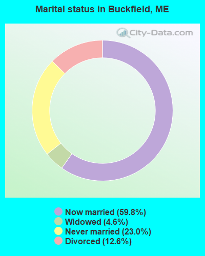
- Never married: 23.0%
- Now married: 59.8%
- Separated: 0.0%
- Widowed: 4.6%
- Divorced: 12.6%
For population 25 years and over in Buckfield:
- High school or higher: 86.9%
- Bachelor's degree or higher: 16.9%
- Graduate or professional degree: 4.7%
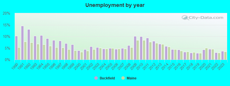
- Unemployed: 2.6%
- Mean travel time to work (commute): 27.9 minutes
| Here: | 10.2 |
| Maine average: | 11.2 |
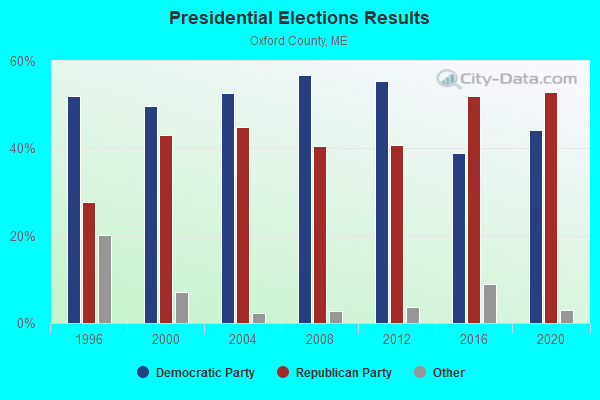
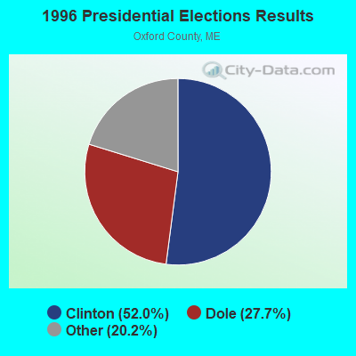
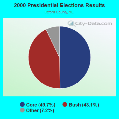
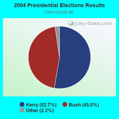
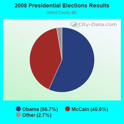

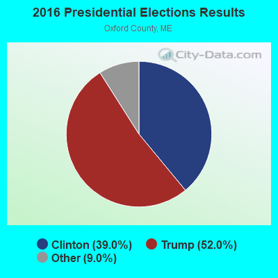

Graphs represent county-level data. Detailed 2008 Election Results
Religion statistics for Buckfield, ME (based on Oxford County data)
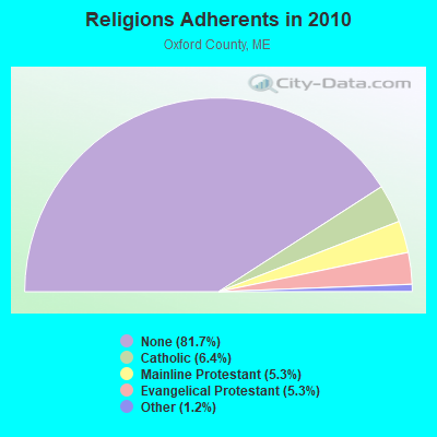
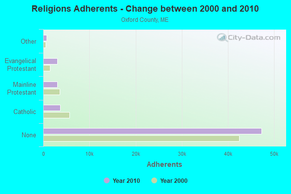
| Religion | Adherents | Congregations |
|---|---|---|
| Catholic | 3,708 | 7 |
| Mainline Protestant | 3,085 | 45 |
| Evangelical Protestant | 3,045 | 37 |
| Other | 719 | 14 |
| None | 47,276 | - |
Food Environment Statistics:
| This county: | 2.47 / 10,000 pop. |
| Maine: | 2.80 / 10,000 pop. |
| Oxford County: | 0.35 / 10,000 pop. |
| Maine: | 0.14 / 10,000 pop. |
| Oxford County: | 2.29 / 10,000 pop. |
| Maine: | 2.20 / 10,000 pop. |
| Oxford County: | 7.94 / 10,000 pop. |
| State: | 5.75 / 10,000 pop. |
| Oxford County: | 9.35 / 10,000 pop. |
| State: | 11.02 / 10,000 pop. |
| This county: | 7.6% |
| Maine: | 8.2% |
| This county: | 25.6% |
| Maine: | 25.0% |
Businesses in Buckfield, ME
- MasterBrand Cabinets: 2
Strongest AM radio stations in Buckfield:
- WTME (780 AM; 10 kW; RUMFORD, ME; Owner: MOUNTAIN VALLEY BROADCASTING, INC.)
- WLAM (1470 AM; 5 kW; LEWISTON, ME; Owner: RADIO PARTNERS OF MAINE, L.P.)
- WKTQ (1450 AM; 1 kW; SOUTH PARIS, ME; Owner: PENNESSEEWASSEE BROADCASTING CO INC.)
- WMTW (870 AM; 10 kW; GORHAM, ME; Owner: RADIO PARTNERS OF MAINE, L.P.)
- WFAU (1280 AM; 5 kW; GARDINER, ME; Owner: CAPSTAR TX LIMITED PARTNERSHIP)
- WGAN (560 AM; 5 kW; PORTLAND, ME; Owner: SAGA COMMUNICATIONS OF NEW ENGLAND, LLC)
- WCNM (1240 AM; 1 kW; LEWISTON, ME; Owner: CHRISTIAN FAMILY RADIO, INC.)
- WSKW (1160 AM; 10 kW; SKOWHEGAN, ME; Owner: MOUNTAIN WIRELESS, INCORPORATED)
- WRKO (680 AM; 50 kW; BOSTON, MA; Owner: ENTERCOM BOSTON LICENSE, LLC)
- WEEI (850 AM; 50 kW; BOSTON, MA; Owner: ENTERCOM BOSTON LICENSE, LLC)
- WBZ (1030 AM; 50 kW; BOSTON, MA; Owner: INFINITY BROADCASTING OPERATIONS, INC.)
- WZAN (970 AM; 5 kW; PORTLAND, ME; Owner: SAGA COMMUNICATIONS OF NEW ENGLAND, LLC)
- WCRN (830 AM; 50 kW; WORCESTER, MA; Owner: CARTER BROADCASTING CORPORATION)
Strongest FM radio stations in Buckfield:
- WPKQ (103.7 FM; NORTH CONWAY, NH; Owner: CITADEL BROADCASTING COMPANY)
- WHOM (94.9 FM; MT. WASHINGTON, NH; Owner: CITADEL BROADCASTING COMPANY)
- WLOB-FM (96.3 FM; RUMFORD, ME; Owner: ATLANTIC COAST RADIO, LLC)
- WTBM (100.7 FM; MEXICO, ME; Owner: MOUNTAIN VALLEY BROADCASTING, INC.)
- WBLM (102.9 FM; PORTLAND, ME; Owner: CITADEL BROADCASTING COMPANY)
- WMEA (90.1 FM; PORTLAND, ME; Owner: MAINE PUBLIC BROADCASTING CORPORATION)
- WOXO-FM (92.7 FM; NORWAY, ME; Owner: TRI-COUNTY BROADCASTING, INC.)
- WTHT (107.5 FM; LEWISTON, ME; Owner: RADIO PARTNERS OF MAINE, L.P.)
- WTOS-FM (105.1 FM; SKOWHEGAN, ME; Owner: CAPSTAR TX LIMITED PARTNERSHIP)
- WCYI (93.9 FM; LEWISTON, ME; Owner: CITADEL BROADCASTING COMPANY)
- WMEK-FM (99.9 FM; AUBURN, ME; Owner: RADIO PARTNERS OF MAINE, L.P.)
- WJBQ (97.9 FM; PORTLAND, ME; Owner: CITADEL BROADCASTING COMPANY)
- WSCY (106.9 FM; MOULTONBOROUGH, NH; Owner: NORTHEAST COMMUNICATIONS CORPORATION)
- WMTW-FM (106.7 FM; NORTH WINDHAM, ME; Owner: RADIO PARTNERS OF MAINE, L.P.)
- WBCI (105.9 FM; BATH, ME; Owner: BLOUNT COMMUNICATIONS, INC.)
- WKTJ-FM (99.3 FM; FARMINGTON, ME; Owner: FRANKLIN BROADCASTING CORPORATION)
- WABK-FM (104.3 FM; GARDINER, ME; Owner: CAPSTAR TX LIMITED PARTNERSHIP)
TV broadcast stations around Buckfield:
- WGME-TV (Channel 13; PORTLAND, ME; Owner: WGME LICENSEE, LLC)
- WMTW-TV (Channel 8; POLAND SPRING, ME; Owner: WMTW BROADCAST GROUP, LLC)
- WPFO (Channel 23; WATERVILLE, ME; Owner: CMCG PORTLAND LICENSE LLC)
- WCSH (Channel 6; PORTLAND, ME; Owner: PACIFIC AND SOUTHERN COMPANY, INC.)
- WCBB (Channel 10; AUGUSTA, ME; Owner: MAINE PUBLIC BROADCASTING CORP.)
- WPXT (Channel 51; PORTLAND, ME; Owner: HMW, INC.)
- WPME (Channel 35; LEWISTON, ME; Owner: KB PRIME MEDIA LLC)
- W32CA (Channel 32; PORTLAND, ME; Owner: NATIONAL MINORITY T.V., INC.)
- Buckfield, Maine
- Fatal accident count17
- Vehicles involved in fatal accidents24
- Fatal accidents involving drunk persons:6
- Fatalities17
- Persons involved in fatal accidents33
- Pedestrians involved in fatal accidents3
- Maine average
- Fatal accident count2370
- Vehicles involved in fatal accidents3442
- Fatal accidents involving drunk persons826
- Fatalities2609
- Persons involved in fatal accidents5623
- Pedestrians involved in fatal accidents223
- National Bridge Inventory (NBI) Statistics
- 7Number of bridges
- 56ft / 17.4mTotal length
- 10,252Total average daily traffic
- 510Total average daily truck traffic
- 14,825Total future (year 2036) average daily traffic
FCC Registered Antenna Towers:
9 (See the full list of FCC Registered Antenna Towers in Buckfield)FCC Registered Broadcast Land Mobile Towers:
3- Streaked Mountain Antenna Site (Lat: 44.249806 Lon: -70.421444), Call Sign: KUS561,
Assigned Frequencies: 154.070 MHz, 154.310 MHz, Grant Date: 03/02/2023, Expiration Date: 04/21/2033, Registrant: Oxford County Communications, 26 Western Ave, Oxford, ME 04281, Phone: (207) 743-9554, Email:
- Streaked Mountain (Lat: 44.249806 Lon: -70.421444), Structure height: 23 m, Call Sign: WPBZ549, Licensee ID: L00006533,
Assigned Frequencies: 458.450 MHz, Grant Date: 01/29/2003, Expiration Date: 04/07/2013, Cancellation Date: 06/08/2013, Registrant: County Of Oxford, South Paris, ME 04281, Phone: (800) 482-7433
- Depot St (Lat: 44.284778 Lon: -70.371722), Call Sign: KJD672, Licensee ID: L00032693,
Assigned Frequencies: 35.1600 MHz, Grant Date: 08/06/1997, Expiration Date: 10/01/2002, Cancellation Date: 01/12/2003, Registrant: Oxford County Telephone Co, Depot St, Buckfield, ME 04220, Phone: (207) 336-9911
FCC Registered Microwave Towers:
14 (See the full list of FCC Registered Microwave Towers in this town)FCC Registered Paging Towers:
1 (See the full list of FCC Registered Paging Towers)FCC Registered Amateur Radio Licenses:
28 (See the full list of FCC Registered Amateur Radio Licenses in Buckfield)FAA Registered Aircraft:
6- Aircraft: PIPER PA-12 (Category: Land, Seats: 3, Weight: Up to 12,499 Pounds, Speed: 82 mph), Engine: LYCOMING 0-360-A1D (180 HP) (Reciprocating)
N-Number: 3806M, N3806M, N-3806M, Serial Number: 12-2563, Year manufactured: 1947, Airworthiness Date: 07/10/1997, Certificate Issue Date: 08/06/2014
Registrant (Co-Owned): Cedric M Abbott, 66 Gesner Rd, Buckfield, ME 04220, Other Owners: Norma B Abbott - Aircraft: TAYLORCRAFT BC12-D (Category: Land, Seats: 2, Weight: Up to 12,499 Pounds, Speed: 78 mph), Engine: CONT MOTOR A&C65 SERIES (65 HP) (Reciprocating)
N-Number: 43937, N43937, N-43937, Serial Number: 7596, Year manufactured: 1946, Airworthiness Date: 10/22/1986, Certificate Issue Date: 08/03/2017
Registrant (Individual): Cedric M Abbott, 66 Gesner Rd, Buckfield, ME 04220 - Aircraft: PIPER PA-16 (Category: Land, Seats: 4, Weight: Up to 12,499 Pounds, Speed: 87 mph), Engine: LYCOMING 0-235 SERIES (115 HP) (Reciprocating)
N-Number: 6831K, N6831K, N-6831K, Serial Number: 16-667, Year manufactured: 1949, Airworthiness Date: 04/27/1956, Certificate Issue Date: 11/09/2012
Registrant (Individual): Cedric M Abbott, 66 Gesner Rd, Buckfield, ME 04220 - Aircraft: GLOBE GC-1B (Category: Land, Seats: 2, Weight: Up to 12,499 Pounds, Speed: 105 mph), Engine: CONT MOTOR C125 SERIES (125 HP) (Reciprocating)
N-Number: 78007, N78007, N-78007, Serial Number: 2007, Year manufactured: 1946, Airworthiness Date: 01/07/1958, Certificate Issue Date: 08/03/2017
Registrant (Individual): Cedric M Abbott, 66 Gesner Rd, Buckfield, ME 04220 - Aircraft: GLOBE GC-1B (Category: Land, Seats: 2, Weight: Up to 12,499 Pounds, Speed: 105 mph), Engine: CONT MOTOR C145 SERIES (145 HP) (Reciprocating)
N-Number: 78116, N78116, N-78116, Serial Number: 2116, Year manufactured: 1946, Airworthiness Date: 09/28/1956, Certificate Issue Date: 02/12/2014
Registrant (Co-Owned): Cedric M Abbott, 66 Gesner Rd, Buckfield, ME 04220, Other Owners: Norma B Abbott - Aircraft: CESSNA 120 (Category: Land, Seats: 2, Weight: Up to 12,499 Pounds, Speed: 90 mph), Engine: CONT MOTOR C85 SERIES (85 HP) (Reciprocating)
N-Number: 89925, N89925, N-89925, Serial Number: 8974, Airworthiness Date: 09/22/1955, Certificate Issue Date: 11/22/2019
Registrant (Individual): Cedric M Abbott, 66 Gesner Rd, Buckfield, ME 04220
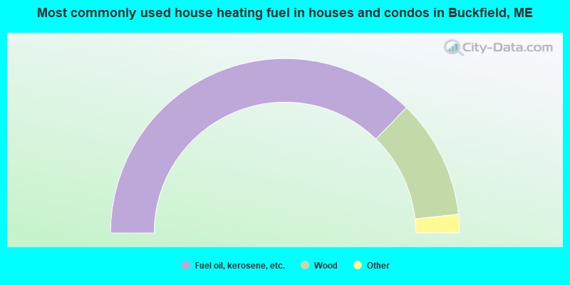
- 74.5%Fuel oil, kerosene, etc.
- 22.1%Wood
- 3.0%Bottled, tank, or LP gas
- 0.4%Electricity
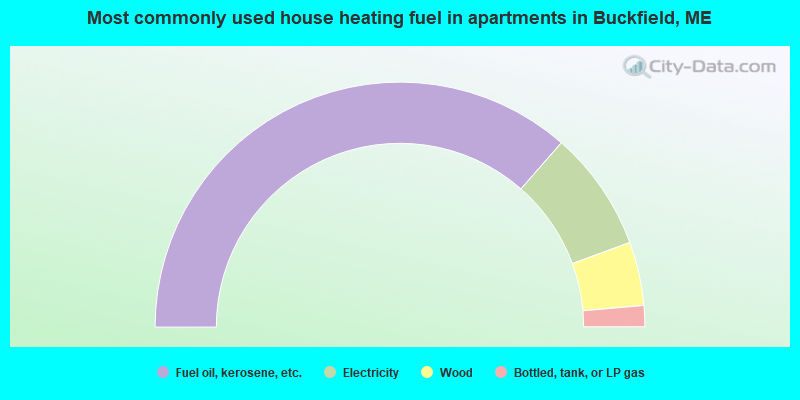
- 72.9%Fuel oil, kerosene, etc.
- 15.9%Electricity
- 8.4%Wood
- 2.8%Bottled, tank, or LP gas
Buckfield compared to Maine state average:
- Unemployed percentage significantly below state average.
- Black race population percentage significantly below state average.
- Hispanic race population percentage significantly below state average.
- Foreign-born population percentage significantly below state average.
- Renting percentage below state average.
- Length of stay since moving in significantly above state average.
- Number of rooms per house significantly below state average.
- House age significantly below state average.
- Percentage of population with a bachelor's degree or higher below state average.

|
Total of 3 patent applications in 2008-2024.