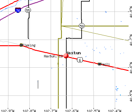
Haxtun, Colorado
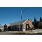
Haxtun: Church, UMC
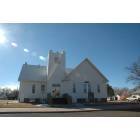
Haxtun: Church
Haxtun: hotel
Haxtun: Engine Joe's
Haxtun: Post Office
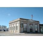
Haxtun: Town Hall
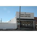
Haxtun

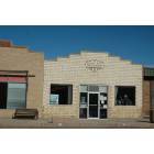
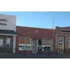
Haxtun: Grocery
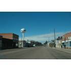
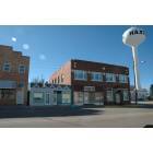
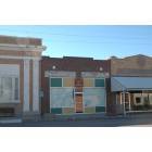
Haxtun: Main Street
Haxtun: Library
- add
your
Submit your own pictures of this town and show them to the world
- OSM Map
- General Map
- Google Map
- MSN Map
Population change since 2000: -1.9%
 |
| Males: 397 | |
| Females: 566 |
| Median resident age: | 47.2 years |
| Colorado median age: | 37.7 years |
Zip codes: 80731.
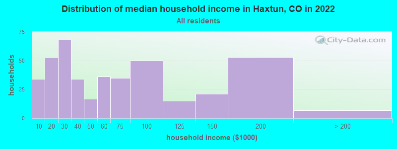
| Haxtun: | $51,482 |
| CO: | $89,302 |
Estimated per capita income in 2022: $31,650 (it was $16,370 in 2000)
Haxtun town income, earnings, and wages data
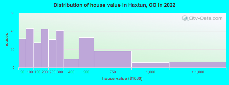
Estimated median house or condo value in 2022: $231,409 (it was $75,500 in 2000)
| Haxtun: | $231,409 |
| CO: | $531,100 |
Mean prices in 2022: all housing units: $297,950; detached houses: $328,178; mobile homes: $39,337
Median gross rent in 2022: $839.
(19.1% for White Non-Hispanic residents, 94.5% for Hispanic or Latino residents, 82.8% for two or more races residents)
Detailed information about poverty and poor residents in Haxtun, CO
Compare current foreclosures near your location:
| Photo | Address | Area | Beds / Baths | Price | Details |
|---|---|---|---|---|---|

|
#1
S High St
Columbus, OH 43207
|
1,678 sq. feet
|
2 baths 4 beds |
$31,900
|
show details |

|
#2
Bayberry Cir
Columbus, OH 43207
|
1,564 sq. feet
|
1 baths 3 beds |
$127,500
|
show details |

|
#3
E 21st Ave
Columbus, OH 43211
|
1,061 sq. feet
|
1 baths 3 beds |
$187,900
|
show details |

|
#4
N Grener Ave
Columbus, OH 43228
|
1,120 sq. feet
|
1 baths 3 beds |
show details | |

|
#5
S Chillicothe St
Plain City, OH 43064
|
1,736 sq. feet
|
2 baths 4 beds |
show details | |

|
#6
Ferris Rd
Columbus, OH 43224
|
2,218 sq. feet
|
3 baths 3 beds |
show details | |

|
#7
High Free Pike
West Jefferson, OH 43162
|
1,216 sq. feet
|
2 baths 4 beds |
show details | |

|
#8
Mink St SW
Pataskala, OH 43062
|
1,442 sq. feet
|
1 baths 3 beds |
show details | |

|
#9
Meadowbrook Dr
Columbus, OH 43207
|
1,752 sq. feet
|
2 baths 4 beds |
show details | |

|
#10
Vineyard Haven Loop
Dublin, OH 43016
|
4,625 sq. feet
|
4 baths 4 beds |
show details |
| Photo | Address | Area | Beds / Baths | Price | Details |
|---|---|---|---|---|---|

|
#11
Falls Peak Ln
Delaware, OH 43015
|
1,352 sq. feet
|
2 baths 2 beds |
show details | |

|
#12
S Hague Ave
Columbus, OH 43204
|
979 sq. feet
|
1 baths 2 beds |
show details | |

|
#13
Striebel Ct
Columbus, OH 43227
|
925 sq. feet
|
1 baths 3 beds |
show details | |

|
#14
Wrexham Ave
Columbus, OH 43223
|
1,235 sq. feet
|
1 baths 3 beds |
show details | |

|
#15
Bunch Flower Ct
Westerville, OH 43082
|
3,173 sq. feet
|
2 baths 4 beds |
show details | |

|
#16
Kingsglen Dr
Grove City, OH 43123
|
1,635 sq. feet
|
2 baths 4 beds |
show details | |

|
#17
Midland Ave
Columbus, OH 43223
|
1,518 sq. feet
|
1 baths 2 beds |
show details | |

|
#18
Derrer Rd -872
Columbus, OH 43204
|
1,667 sq. feet
|
2 baths 5 beds |
show details | |

|
#19
Mayflower Blvd
Columbus, OH 43213
|
1,591 sq. feet
|
2 baths 4 beds |
show details | |

|
#20
Bretton Pl
Columbus, OH 43211
|
1,056 sq. feet
|
1 baths 3 beds |
show details |
| Photo | Address | Area | Beds / Baths | Price | Details |
|---|---|---|---|---|---|

|
#21
Trotter Dr
Columbus, OH 43207
|
1,478 sq. feet
|
1 baths 3 beds |
show details | |

|
#22
S Richardson Ave
Columbus, OH 43204
|
1,520 sq. feet
|
2 baths 3 beds |
show details | |

|
#23
Fergus Rd
Grove City, OH 43123
|
3,312 sq. feet
|
2 baths 4 beds |
show details | |

|
#24
Stoneybrook Blvd # 21a
Hilliard, OH 43026
|
1,231 sq. feet
|
2 baths 3 beds |
show details | |

|
#25
Hiawatha Park Dr
Columbus, OH 43211
|
1,278 sq. feet
|
1 baths 4 beds |
show details | |

|
#26
Edgeview Rd
Columbus, OH 43207
|
1,700 sq. feet
|
1 baths 4 beds |
show details | |

|
#27
Belle Oak Dr
Galloway, OH 43119
|
1,296 sq. feet
|
2 baths 3 beds |
show details | |

|
#28
Scottwood Rd
Columbus, OH 43227
|
1,008 sq. feet
|
1 baths 3 beds |
show details | |

|
#29
N Roys Ave
Columbus, OH 43204
|
1,248 sq. feet
|
2 baths 3 beds |
show details | |

|
#30
Elaine Rd
Columbus, OH 43213
|
764 sq. feet
|
1 baths 2 beds |
show details |
| Photo | Address | Area | Beds / Baths | Price | Details |
|---|---|---|---|---|---|

|
#31
Fahlander Dr N
Columbus, OH 43229
|
1,338 sq. feet
|
2 baths 3 beds |
show details | |

|
#32
Brookstone Dr
Westerville, OH 43082
|
1,783 sq. feet
|
3 baths 3 beds |
show details | |

|
#33
Rosewood Ct
Powell, OH 43065
|
2,801 sq. feet
|
3 baths 4 beds |
show details | |

|
#34
Sleeping Meadow Dr
New Albany, OH 43054
|
3,211 sq. feet
|
2 baths 4 beds |
show details | |

|
#35
Marshrun Dr
Grove City, OH 43123
|
2,036 sq. feet
|
2 baths 4 beds |
show details | |

|
#36
Bernadette Rd
Columbus, OH 43204
|
1,168 sq. feet
|
1 baths 3 beds |
show details | |

|
#37
Nantucket Ave
Columbus, OH 43235
|
1,864 sq. feet
|
2 baths 3 beds |
show details | |

|
#38
Messner Dr
Hilliard, OH 43026
|
832 sq. feet
|
1 baths 2 beds |
show details | |

|
#39
Saint James Ct
Columbus, OH 43220
|
1,314 sq. feet
|
1 baths 2 beds |
show details | |

|
#40
Falene Pl
Galloway, OH 43119
|
1,178 sq. feet
|
1 baths 3 beds |
show details |
| Photo | Address | Area | Beds / Baths | Price | Details |
|---|---|---|---|---|---|

|
#41
Wesson Dr
Columbus, OH 43232
|
1,200 sq. feet
|
1 baths 3 beds |
show details | |

|
#42
Ridgebury Dr
Hilliard, OH 43026
|
832 sq. feet
|
1 baths 2 beds |
show details | |

|
#43
Tea Party Pl
Columbus, OH 43207
|
1,176 sq. feet
|
2 baths 3 beds |
show details | |

|
#44
Legionary St
Columbus, OH 43207
|
1,356 sq. feet
|
2 baths 3 beds |
show details | |

|
#45
Barthel Ave
Columbus, OH 43227
|
1,276 sq. feet
|
1 baths 3 beds |
show details | |

|
#46
Pendent Ln
Columbus, OH 43207
|
1,260 sq. feet
|
2 baths 3 beds |
show details | |

|
#47
Bloomington Blvd
Columbus, OH 43228
|
1,940 sq. feet
|
2 baths 2 beds |
show details | |

|
#48
Oreily Dr
Galloway, OH 43119
|
1,533 sq. feet
|
2 baths 3 beds |
show details | |

|
#49
Walnut Creek Dr
Columbus, OH 43224
|
1,412 sq. feet
|
1 baths 3 beds |
show details | |

|
Check over 1 million property listings on Foreclosure.com!
|
browse all offers | |||


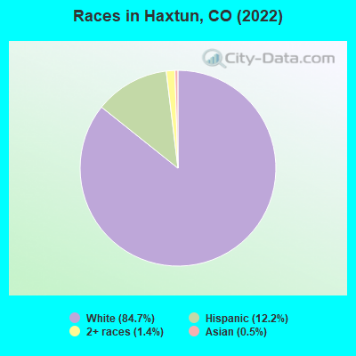
- 78584.7%White alone
- 11312.2%Hispanic
- 131.4%Two or more races
- 50.5%Asian alone
According to our research of Colorado and other state lists, there were 7 registered sex offenders living in Haxtun, Colorado as of April 26, 2024.
The ratio of all residents to sex offenders in Haxtun is 142 to 1.
Type |
2009 |
2010 |
2011 |
2012 |
2013 |
2014 |
2015 |
2016 |
2017 |
2018 |
2019 |
2020 |
2021 |
2022 |
|---|---|---|---|---|---|---|---|---|---|---|---|---|---|---|
| Murders (per 100,000) | 0 (0.0) | 0 (0.0) | 0 (0.0) | 0 (0.0) | 0 (0.0) | 0 (0.0) | 0 (0.0) | 0 (0.0) | 0 (0.0) | 0 (0.0) | 0 (0.0) | 0 (0.0) | 0 (0.0) | 0 (0.0) |
| Rapes (per 100,000) | 0 (0.0) | 0 (0.0) | 0 (0.0) | 0 (0.0) | 0 (0.0) | 0 (0.0) | 1 (107.6) | 0 (0.0) | 0 (0.0) | 0 (0.0) | 0 (0.0) | 0 (0.0) | 0 (0.0) | 0 (0.0) |
| Robberies (per 100,000) | 0 (0.0) | 0 (0.0) | 0 (0.0) | 0 (0.0) | 0 (0.0) | 0 (0.0) | 0 (0.0) | 0 (0.0) | 0 (0.0) | 0 (0.0) | 1 (110.9) | 0 (0.0) | 0 (0.0) | 0 (0.0) |
| Assaults (per 100,000) | 1 (103.8) | 0 (0.0) | 0 (0.0) | 1 (105.3) | 1 (108.0) | 0 (0.0) | 3 (322.9) | 1 (108.0) | 0 (0.0) | 0 (0.0) | 0 (0.0) | 0 (0.0) | 0 (0.0) | 0 (0.0) |
| Burglaries (per 100,000) | 0 (0.0) | 0 (0.0) | 1 (104.0) | 0 (0.0) | 2 (216.0) | 0 (0.0) | 0 (0.0) | 2 (216.0) | 1 (109.6) | 1 (110.0) | 0 (0.0) | 0 (0.0) | 0 (0.0) | 0 (0.0) |
| Thefts (per 100,000) | 4 (415.4) | 0 (0.0) | 4 (415.8) | 2 (210.5) | 1 (108.0) | 3 (324.7) | 6 (645.9) | 19 (2,052) | 6 (657.9) | 6 (660.1) | 8 (886.9) | 9 (1,001) | 6 (641.0) | 0 (0.0) |
| Auto thefts (per 100,000) | 0 (0.0) | 0 (0.0) | 0 (0.0) | 0 (0.0) | 0 (0.0) | 0 (0.0) | 0 (0.0) | 0 (0.0) | 0 (0.0) | 0 (0.0) | 0 (0.0) | 1 (111.2) | 1 (106.8) | 0 (0.0) |
| Arson (per 100,000) | 0 (0.0) | 0 (0.0) | 0 (0.0) | 0 (0.0) | 0 (0.0) | 0 (0.0) | 0 (0.0) | 0 (0.0) | 0 (0.0) | 0 (0.0) | 0 (0.0) | 1 (111.2) | 0 (0.0) | 0 (0.0) |
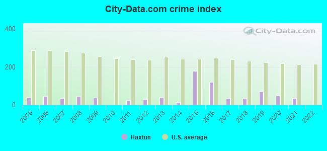
| City-Data.com crime index | 37.4 | 0.0 | 23.9 | 29.5 | 41.0 | 13.0 | 176.5 | 118.8 | 34.0 | 34.1 | 68.7 | 48.9 | 34.2 | 0.0 |
The City-Data.com crime index weighs serious crimes and violent crimes more heavily. Higher means more crime, U.S. average is 246.1. It adjusts for the number of visitors and daily workers commuting into cities.
Crime rate in Haxtun detailed stats: murders, rapes, robberies, assaults, burglaries, thefts, arson
Full-time law enforcement employees in 2021, including police officers: 1 (1 officers - 1 male; 0 female).
| Officers per 1,000 residents here: | 1.07 |
| Colorado average: | 2.14 |
 Recent articles from our blog. Our writers, many of them Ph.D. graduates or candidates, create easy-to-read articles on a wide variety of topics.

 | Ideas for Affordable Places to own a property in CO or AZ or WA or somewhere West (38 replies) |
| Leaving Loveland? (18 replies) |
| Rural properties in No Co (5 replies) |
| Loveland........Seniors vs Young Folks (57 replies) |
| Loveland for conservative Christian retirees? (37 replies) |
| Anyone Else Get Depressed Here By Lack of Flowers/Plant Life in Spring? (96 replies) |
Latest news from Haxtun, CO collected exclusively by city-data.com from local newspapers, TV, and radio stations
Ancestries: German (37.2%), American (7.5%), Polish (6.6%), Irish (4.1%), Italian (3.7%), English (3.4%).
Current Local Time: MST time zone
Incorporated on 7/30/1909
Elevation: 4039 feet
Land area: 0.50 square miles.
Population density: 1,925 people per square mile (low).
33 residents are foreign born (3.2% Latin America).
| This town: | 3.6% |
| Colorado: | 9.5% |
Median real estate property taxes paid for housing units with mortgages in 2022: $1,238 (0.5%)
Median real estate property taxes paid for housing units with no mortgage in 2022: $767 (0.4%)
Nearest city with pop. 50,000+: Greeley, CO  (111.3 miles , pop. 76,930).
Nearest city with pop. 200,000+: Aurora, CO (132.5 miles , pop. 276,393).
Nearest city with pop. 1,000,000+: Dallas, TX (631.4 miles , pop. 1,188,580).
Nearest cities:
), Latitude: 40.64 N, Longitude: 102.63 W
Area code: 970

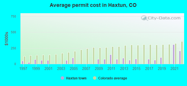
Single-family new house construction building permits:
- 2022: 2 buildings, average cost: $205,500
- 2021: 1 building, cost: $307,500
- 2019: 1 building, cost: $105,000
- 2018: 2 buildings, average cost: $63,400
- 2017: 1 building, cost: $75,000
- 2015: 2 buildings, average cost: $80,000
- 2014: 3 buildings, average cost: $64,100
- 2013: 2 buildings, average cost: $95,600
- 2012: 1 building, cost: $76,800
- 2011: 1 building, cost: $150,000
- 2010: 2 buildings, average cost: $75,800
- 2009: 1 building, cost: $75,700
- 2005: 2 buildings, average cost: $100,000
- 2004: 1 building, cost: $60,000
- 2001: 6 buildings, average cost: $56,600
- 2000: 2 buildings, average cost: $60,000
- 1999: 5 buildings, average cost: $72,800
- 1998: 1 building, cost: $28,000
- 1997: 3 buildings, average cost: $50,000

| Here: | 1.8% |
| Colorado: | 3.2% |
- Health care (15.5%)
- Construction (13.4%)
- Agriculture, forestry, fishing & hunting (7.9%)
- Educational services (7.9%)
- Accommodation & food services (6.9%)
- Public administration (4.5%)
- Professional, scientific, technical services (3.8%)
- Construction (22.8%)
- Agriculture, forestry, fishing & hunting (14.6%)
- Public administration (5.5%)
- Accommodation & food services (5.0%)
- Health care (5.0%)
- Educational services (5.0%)
- Professional, scientific, technical services (4.1%)
- Health care (27.0%)
- Educational services (11.0%)
- Accommodation & food services (9.0%)
- Food & beverage stores (6.5%)
- Publishing, motion picture & sound recording industries (4.0%)
- Finance & insurance (4.0%)
- Public administration (3.5%)
- Other sales and related occupations, including supervisors (5.0%)
- Electrical equipment mechanics and other installation, maintenance, and repair workers, including supervisors (4.5%)
- Other management occupations, except farmers and farm managers (4.1%)
- Driver/sales workers and truck drivers (4.1%)
- Building and grounds cleaning and maintenance occupations (4.1%)
- Sales representatives, services, wholesale and manufacturing (3.6%)
- Farmers and farm managers (3.1%)
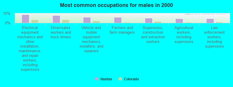
- Electrical equipment mechanics and other installation, maintenance, and repair workers, including supervisors (8.7%)
- Driver/sales workers and truck drivers (7.8%)
- Vehicle and mobile equipment mechanics, installers, and repairers (5.9%)
- Farmers and farm managers (5.9%)
- Supervisors, construction and extraction workers (5.0%)
- Agricultural workers, including supervisors (4.6%)
- Law enforcement workers, including supervisors (4.6%)
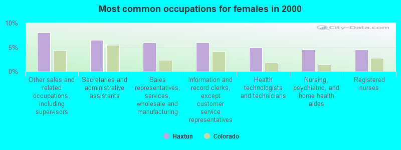
- Other sales and related occupations, including supervisors (8.0%)
- Secretaries and administrative assistants (6.5%)
- Sales representatives, services, wholesale and manufacturing (6.0%)
- Information and record clerks, except customer service representatives (6.0%)
- Health technologists and technicians (5.0%)
- Nursing, psychiatric, and home health aides (4.5%)
- Registered nurses (4.5%)
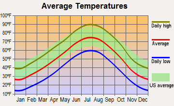
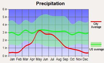
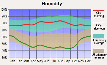
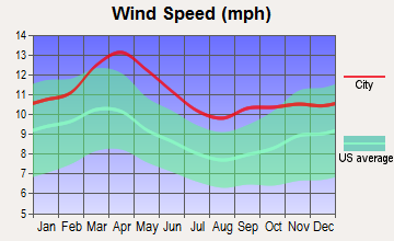
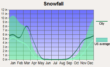
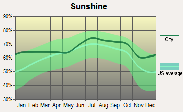
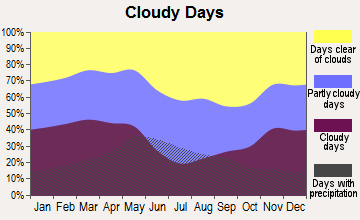
Average climate in Haxtun, Colorado
Based on data reported by over 4,000 weather stations
Tornado activity:
Haxtun-area historical tornado activity is above Colorado state average. It is 7% greater than the overall U.S. average.
On 7/5/2000, a category F3 (max. wind speeds 158-206 mph) tornado 4.6 miles away from the Haxtun town center injured 2 people and caused $750,000 in damages.
On 6/27/1960, a category F3 tornado 16.1 miles away from the town center killed 2 people and injured 3 people and caused between $50,000 and $500,000 in damages.
Earthquake activity:
Haxtun-area historical earthquake activity is significantly above Colorado state average. It is 487% greater than the overall U.S. average.On 8/18/1959 at 06:37:13, a magnitude 7.7 (7.7 UK, Class: Major, Intensity: VIII - XII) earthquake occurred 490.2 miles away from the city center, causing $26,000,000 total damage
On 10/18/1984 at 15:30:23, a magnitude 5.5 (5.4 MB, 5.1 MS, 5.5 ML, Class: Moderate, Intensity: VI - VII) earthquake occurred 194.6 miles away from Haxtun center
On 8/23/2011 at 05:46:18, a magnitude 5.3 (5.3 MW, Depth: 2.5 mi) earthquake occurred 271.5 miles away from Haxtun center
On 10/28/1983 at 14:06:06, a magnitude 7.3 (6.2 MB, 7.3 MS, 7.0 MW) earthquake occurred 617.9 miles away from Haxtun center, causing 2 deaths (2 shaking deaths) and 3 injuries, causing $15,000,000 total damage
On 6/22/2019 at 08:50:24, a magnitude 4.6 (4.6 MW, Depth: 1.9 mi, Class: Light, Intensity: IV - V) earthquake occurred 196.4 miles away from Haxtun center
On 9/8/1984 at 00:59:31, a magnitude 5.1 (5.1 MB) earthquake occurred 299.7 miles away from Haxtun center
Magnitude types: body-wave magnitude (MB), local magnitude (ML), surface-wave magnitude (MS), moment magnitude (MW)
Natural disasters:
The number of natural disasters in Phillips County (5) is a lot smaller than the US average (15).Major Disasters (Presidential) Declared: 3
Emergencies Declared: 1
Causes of natural disasters: Floods: 2, Storms: 2, Hurricane: 1, Tornado: 1, Other: 1 (Note: some incidents may be assigned to more than one category).

Hospitals and medical centers in Haxtun:
Airports located in Haxtun:
- Haxtun Municipal Airport (17V) (Runways: 2, Itinerant Ops: 160, Local Ops: 110)
Colleges/universities with over 2000 students nearest to Haxtun:
- University of Northern Colorado (about 111 miles; Greeley, CO; Full-time enrollment: 11,469)
- Aims Community College (about 114 miles; Greeley, CO; FT enrollment: 3,598)
- Laramie County Community College (about 118 miles; Cheyenne, WY; FT enrollment: 3,288)
- Colorado State University-Fort Collins (about 129 miles; Fort Collins, CO; FT enrollment: 25,099)
- Community College of Aurora (about 132 miles; Aurora, CO; FT enrollment: 4,730)
- Front Range Community College (about 138 miles; Westminster, CO; FT enrollment: 14,756)
- Colorado State University-Global Campus (about 140 miles; Greenwood Village, CO; FT enrollment: 3,642)
Public high school in Haxtun:
- HAXTUN HIGH SCHOOL (Students: 95, Location: 201 WEST POWELL STREET, Grades: 9-12)
Public elementary/middle school in Haxtun:
- HAXTUN ELEMENTARY SCHOOL (Students: 218, Location: 601 NORTH COLORADO AVENUE, Grades: PK-8)
Points of interest:
Notable location: Haxtun Fire Department (A). Display/hide its location on the map
Drinking water stations with addresses in Haxtun and their reported violations in the past:
HAXTUN TOWN OF (Population served: 952, Groundwater):Past monitoring violations:
- Monitoring, Source Water (GWR) - In DEC-2013, Contaminant: E. COLI. Follow-up actions: St Violation/Reminder Notice (FEB-10-2014), St Public Notif requested (FEB-10-2014)
- Monitoring, Repeat Major (TCR) - In DEC-2013, Contaminant: Coliform (TCR). Follow-up actions: St Public Notif requested (FEB-10-2014), St Violation/Reminder Notice (FEB-10-2014), St Public Notif requested (FEB-10-2014), St Violation/Reminder Notice (FEB-10-2014)
- Monitoring and Reporting (DBP) - Between OCT-2013 and DEC-2013, Contaminant: Chlorine. Follow-up actions: St Violation/Reminder Notice (FEB-10-2014), St Public Notif requested (FEB-10-2014)
- Monitoring, Routine (IDSE) - In APR-01-2008, Contaminant: DBP STAGE 2. Follow-up actions: St Violation/Reminder Notice (JUL-15-2008), St Compliance achieved (JUL-23-2008)
- Follow-up Or Routine LCR Tap M/R - In OCT-01-2007, Contaminant: Lead and Copper Rule. Follow-up actions: St Public Notif requested (FEB-01-2008), St Violation/Reminder Notice (FEB-01-2008), St Compliance achieved (FEB-04-2009)
- 159 regular monitoring violations
- 4 other older monitoring violations
| This town: | 2.3 people |
| Colorado: | 2.5 people |
| This town: | 63.5% |
| Whole state: | 63.9% |
| This town: | 3.7% |
| Whole state: | 6.5% |
Likely homosexual households (counted as self-reported same-sex unmarried-partner households)
- Lesbian couples: 0.0% of all households
- Gay men: 0.2% of all households
2 people in nursing facilities/skilled-nursing facilities in 2010
32 people in nursing homes in 2000
7 people in wards in general hospitals for patients who have no usual home elsewhere in 2000
Banks with branches in Haxtun (2011 data):
- Points West Community Bank: - Haxtun at 128 South Colorado Avenue, branch established on 1944/02/19. Info updated 2011/07/11: Bank assets: $197.1 mil, Deposits: $169.9 mil, headquarters in Julesburg, CO, positive income, Agricultural Specialization, 7 total offices, Holding Company: First Nebraska Bancs, Inc.
For population 15 years and over in Haxtun:
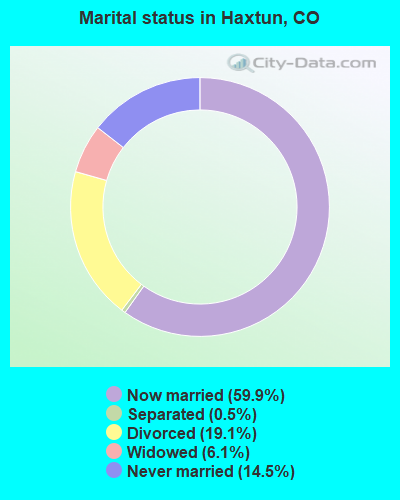
- Never married: 14.5%
- Now married: 59.9%
- Separated: 0.5%
- Widowed: 6.1%
- Divorced: 19.1%
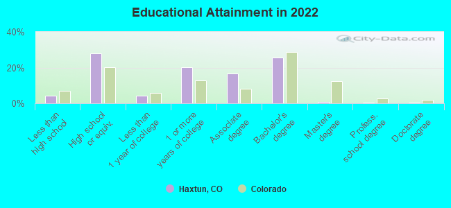
For population 25 years and over in Haxtun:
- High school or higher: 95.1%
- Bachelor's degree or higher: 25.0%
- Graduate or professional degree: 1.3%
- Unemployed: 1.2%
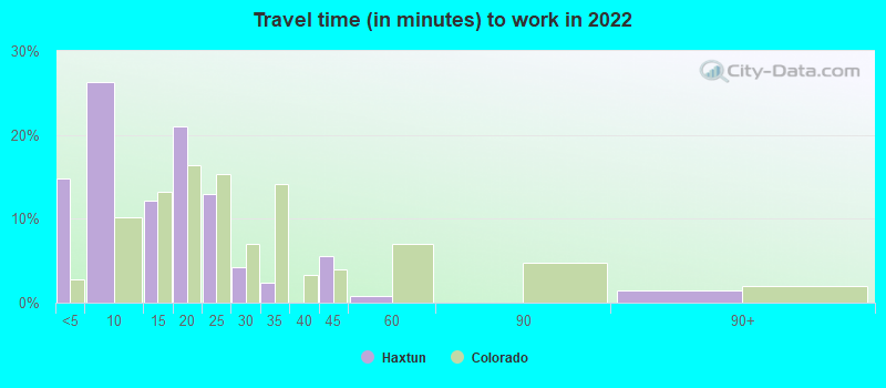
- Mean travel time to work (commute): 15.5 minutes
| Here: | 8.6 |
| Colorado average: | 11.1 |
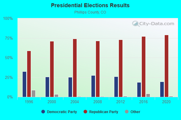
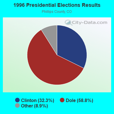
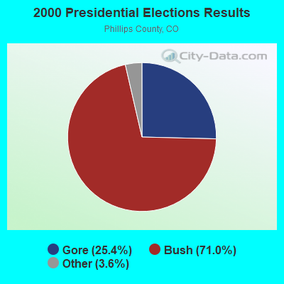
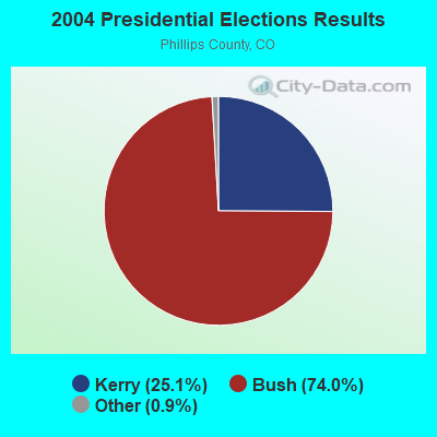

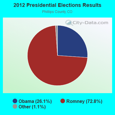
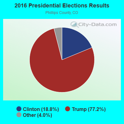
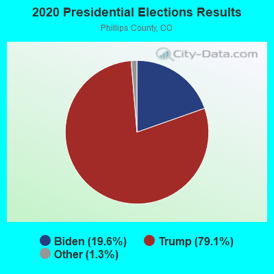
Graphs represent county-level data. Detailed 2008 Election Results
Religion statistics for Haxtun, CO (based on Phillips County data)
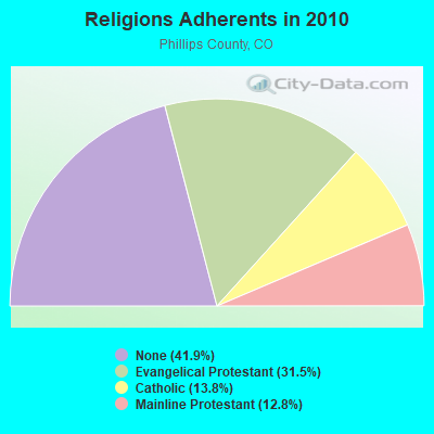
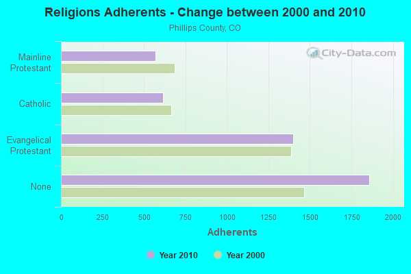
| Religion | Adherents | Congregations |
|---|---|---|
| Evangelical Protestant | 1,401 | 13 |
| Catholic | 613 | 3 |
| Mainline Protestant | 569 | 2 |
| None | 1,859 | - |
Food Environment Statistics:
| This county: | 4.48 / 10,000 pop. |
| State: | 1.50 / 10,000 pop. |
| Phillips County: | 4.48 / 10,000 pop. |
| State: | 3.13 / 10,000 pop. |
| This county: | 11.20 / 10,000 pop. |
| Colorado: | 8.99 / 10,000 pop. |
| Phillips County: | 7.6% |
| Colorado: | 5.3% |
| This county: | 19.6% |
| Colorado: | 18.4% |
| This county: | 13.0% |
| Colorado: | 9.6% |
Health and Nutrition:
| This city: | 52.4% |
| State: | 49.4% |
| Haxtun: | 52.1% |
| Colorado: | 47.8% |
| Haxtun: | 28.9 |
| Colorado: | 28.5 |
| Haxtun: | 19.0% |
| Colorado: | 20.7% |
| Here: | 12.4% |
| Colorado: | 9.7% |
| This city: | 6.9 |
| Colorado: | 6.8 |
| This city: | 41.2% |
| State: | 33.3% |
| Haxtun: | 57.8% |
| Colorado: | 57.3% |
| Here: | 79.4% |
| Colorado: | 80.2% |
More about Health and Nutrition of Haxtun, CO Residents
| Local government employment and payroll (March 2022) | |||||
| Function | Full-time employees | Monthly full-time payroll | Average yearly full-time wage | Part-time employees | Monthly part-time payroll |
|---|---|---|---|---|---|
| Other Government Administration | 5 | $21,831 | $52,394 | 11 | $1,493 |
| Police Protection - Officers | 3 | $12,517 | $50,068 | 0 | $0 |
| Electric Power | 1 | $7,095 | $85,140 | 0 | $0 |
| Water Supply | 1 | $4,108 | $49,296 | 0 | $0 |
| Sewerage | 1 | $4,443 | $53,316 | 0 | $0 |
| Streets and Highways | 1 | $5,709 | $68,508 | 0 | $0 |
| Other and Unallocable | 0 | $0 | 1 | $411 | |
| Police - Other | 0 | $0 | 1 | $1,234 | |
| Local Libraries | 0 | $0 | 1 | $2,783 | |
| Totals for Government | 12 | $55,703 | $55,703 | 14 | $5,921 |
Haxtun government finances - Expenditure in 2021 (per resident):
- Construction - Housing and Community Development: $1,887,000 ($1959.50)
Water Utilities: $166,000 ($172.38)
Parking Facilities: $139,000 ($144.34)
Transit Utilities: $34,000 ($35.31)
Parks and Recreation: $7,000 ($7.27)
General Public Buildings: $1,000 ($1.04)
- Current Operations - Parks and Recreation: $1,845,000 ($1915.89)
General - Other: $1,119,000 ($1161.99)
Central Staff Services: $853,000 ($885.77)
Police Protection: $788,000 ($818.28)
Regular Highways: $788,000 ($818.28)
General Public Buildings: $533,000 ($553.48)
Water Utilities: $406,000 ($421.60)
Housing and Community Development: $179,000 ($185.88)
Financial Administration: $172,000 ($178.61)
Transit Utilities: $131,000 ($136.03)
Parking Facilities: $55,000 ($57.11)
Judicial and Legal Services: $38,000 ($39.46)
Miscellaneous Commercial Activities - Other: $1,000 ($1.04)
- General - Interest on Debt: $107,000 ($111.11)
- Other Capital Outlay - Transit Utilities: $148,000 ($153.69)
- Total Salaries and Wages: $2,706,000 ($2809.97)
- Water Utilities - Interest on Debt: $3,000 ($3.12)
Haxtun government finances - Revenue in 2021 (per resident):
- Charges - Parks and Recreation: $1,196,000 ($1241.95)
Parking Facilities: $97,000 ($100.73)
Housing and Community Development: $6,000 ($6.23)
Miscellaneous Commercial Activities: $3,000 ($3.12)
- Federal Intergovernmental - Transit Utilities: $182,000 ($188.99)
Other: $8,000 ($8.31)
- Local Intergovernmental - Housing and Community Development: $113,000 ($117.34)
Highways: $45,000 ($46.73)
- Miscellaneous - Fines and Forfeits: $100,000 ($103.84)
Interest Earnings: $92,000 ($95.53)
Rents: $84,000 ($87.23)
General Revenue - Other: $68,000 ($70.61)
Sale of Property: $66,000 ($68.54)
Donations From Private Sources: $10,000 ($10.38)
- Revenue - Water Utilities: $758,000 ($787.12)
- State Intergovernmental - Highways: $53,000 ($55.04)
General Local Government Support: $12,000 ($12.46)
- Tax - General Sales and Gross Receipts: $5,840,000 ($6064.38)
Other Selective Sales: $1,348,000 ($1399.79)
Documentary and Stock Transfer: $1,255,000 ($1303.22)
Property: $613,000 ($636.55)
Occupation and Business License - Other: $182,000 ($188.99)
Public Utilities Sales: $178,000 ($184.84)
Amusements Sales: $140,000 ($145.38)
Motor Vehicle License: $30,000 ($31.15)
Alcoholic Beverage License: $11,000 ($11.42)
Other License: $2,000 ($2.08)
Haxtun government finances - Debt in 2021 (per resident):
- Long Term Debt - Beginning Outstanding - Unspecified Public Purpose: $977,000 ($1014.54)
Retired Unspecified Public Purpose: $831,000 ($862.93)
Outstanding Unspecified Public Purpose: $146,000 ($151.61)
Haxtun government finances - Cash and Securities in 2021 (per resident):
- Other Funds - Cash and Securities: $18,492,000 ($19202.49)
Strongest AM radio stations in Haxtun:
- KIMB (1260 AM; 50 kW; KIMBALL, NE; Owner: G & L INVESTMENTS, LLC)
- KSIR (1010 AM; 25 kW; BRUSH, CO; Owner: JMS BROADCASTING, LLC)
- KLTT (670 AM; 50 kW; COMMERCE CITY, CO; Owner: KLZ RADIO, INC.)
- KKZN (760 AM; 50 kW; THORNTON, CO; Owner: JACOR BROADCASTING OF COLORADO, INC.)
- KOA (850 AM; 50 kW; DENVER, CO; Owner: JACOR BROADCASTING OF COLORADO, INC.)
- KMXA (1090 AM; 50 kW; AURORA, CO; Owner: ENTRAVISION HOLDINGS, LLC)
- KRVN (880 AM; 50 kW; LEXINGTON, NE; Owner: NEBRASKA RURAL RADIO ASSOCIATION)
- KRDZ (1440 AM; 5 kW; WRAY, CO; Owner: MEDIA LOGIC, LLC.)
- KLMO (1060 AM; 30 kW; LONGMONT, CO; Owner: PILGRIM COMMUNICATIONS, INC.)
- KOGA (930 AM; 5 kW; OGALLALA, NE; Owner: CAPSTAR TX LIMITED PARTNERSHIP)
- KSTC (1230 AM; 1 kW; STERLING, CO; Owner: ARNOLD BROADCASTING CO., INC.)
- KGAB (650 AM; 8 kW; ORCHARD VALLEY, WY; Owner: CITICASTERS LICENSES, L.P.)
- KTWO (1030 AM; 50 kW; CASPER, WY; Owner: CITICASTERS LICENSES, L.P.)
Strongest FM radio stations in Haxtun:
- KNNG (104.7 FM; STERLING, CO; Owner: ARNOLD BROADCASTING CO., INC.)
- K206BD (89.1 FM; JULESBURG, CO; Owner: REGION 1 TRANSLATOR ASSOCIATION)
- K203DD (88.5 FM; STERLING, CO; Owner: CALVARY CHAPEL OF TWIN FALLS, INC.)
- KADL (102.9 FM; IMPERIAL, NE; Owner: IMPERIAL MEDIA ASSOCIATION)
- KPMX (105.7 FM; STERLING, CO; Owner: JMS BROADCASTING, LLC)
TV broadcast stations around Haxtun:
- K47DE (Channel 47; HAXTUN, CO; Owner: REGION 1 TRANSLATOR ASSOCIATION)
- K51AI (Channel 51; HAXTUN, CO; Owner: REGION 1 TRANSLATOR ASSOCIATION)
- K53AJ (Channel 53; HAXTUN, CO; Owner: REGION 1 TRANSLATOR ASSOCIATION)
- K55CD (Channel 55; HAXTUN, CO; Owner: REGION 1 TRANSLATOR ASSOCIATION)
- K49AF (Channel 49; HAXTUN, CO; Owner: REGION 1 TRANSLATOR ASSOCIATION)
- KUPN (Channel 3; STERLING, CO; Owner: CHANNEL 20 TV COMPANY)
- K44FL (Channel 44; STERLING,S.LOGAN CTY, CO; Owner: BOARD OF LOGAN COUNTY COMMISSIONERS)
- K46CY (Channel 46; STERLING, CO; Owner: BOARD OF LOGAN COUNTY COMMISSIONERS)
- K48DQ (Channel 48; STERLING,S.LOGAN CTY, CO; Owner: BOARD OF LOGAN COUNTY COMMISSIONERS)
- K50EE (Channel 50; STERLING,S.LOGAN CTY, CO; Owner: BOARD OF LOGAN COUNTY COMMISSIONERS)
- K52EW (Channel 52; STERLING,S.LOGAN CTY, CO; Owner: BOARD OF LOGAN COUNTY COMMISSIONERS)
- K54GJ (Channel 54; STERLING, CO; Owner: BOARD OF LOGAN COUNTY COMMISSIONERS)
- K56GL (Channel 56; STERLING, ETC., CO; Owner: BOARD OF LOGAN COUNTY COMMISSIONERS)
- K58GH (Channel 58; STERLING, CO; Owner: BOARD OF LOGAN COUNTY COMMISSIONERS)
- K15FD (Channel 15; HOLYOKE, CO; Owner: REGION 1 TRANSLATOR ASSOCIATION)
- K17EU (Channel 17; HOLYOKE, CO; Owner: REGION 1 TRANSLATOR ASSOCIATION)
- K19EG (Channel 19; HOLYOKE, CO; Owner: REGION 1 TRANSLATOR ASSOCIATION)
- K21FF (Channel 21; HOLYOKE, CO; Owner: REGION 1 TRANSLATOR ASSOCIATION)
- K25GZ (Channel 25; HOLYOKE, CO; Owner: REGION 1 TRANSLATOR ASSOCIATION)
- K31AB (Channel 31; JULESBURG, CO; Owner: REGION 1 TRANSLATOR ASSOCIATION)
- K39AC (Channel 39; JULESBURG, CO; Owner: REGION 1 TRANSLATOR ASSOCIATION)
- K43BY (Channel 43; JULESBURG, CO; Owner: REGION 1 TRANSLATOR ASSOCIATION)
- K35AB (Channel 35; JULESBURG, CO; Owner: REGION 1 TRANSLATOR ASSOCIATION)
- K41AB (Channel 41; JULESBURG, CO; Owner: REGION 1 TRANSLATOR ASSOCIATION)
Haxtun fatal accident list:
Jul 27, 1981 02:40 PM, Vehicles: 2, Persons: 2, Fatalities: 1
- National Bridge Inventory (NBI) Statistics
- 2Number of bridges
- 30ft / 9.2mTotal length
- 670Total average daily traffic
- 144Total average daily truck traffic
- 818Total future (year 2040) average daily traffic
FCC Registered Cell Phone Towers:
2 (See the full list of FCC Registered Cell Phone Towers in Haxtun)FCC Registered Antenna Towers:
39 (See the full list of FCC Registered Antenna Towers)FCC Registered Broadcast Land Mobile Towers:
15 (See the full list of FCC Registered Broadcast Land Mobile Towers in Haxtun, CO)FCC Registered Microwave Towers:
25 (See the full list of FCC Registered Microwave Towers in this town)FCC Registered Amateur Radio Licenses:
4- Call Sign: KA0UFK, Licensee ID: L00222484, Grant Date: 01/11/2024, Expiration Date: 01/11/2034, Certifier: Stephanie D Chaney, Registrant: Stephanie D Chaney, 3813 County Road 32, Haxtun, CO 80731
- Call Sign: N0ELH, Grant Date: 04/28/1999, Expiration Date: 04/28/2009, Cancellation Date: 04/29/2011, Registrant: Paul M Mc Pherron, 208 N Edmund Ave, Haxtun, CO 80731
- Call Sign: N0YEN, Grant Date: 08/24/1993, Expiration Date: 08/24/2003, Cancellation Date: 08/25/2005, Registrant: Monte J Jones, 333 Lava St, Haxtun, CO 80731
- Call Sign: WA0RBR, Previous Call Sign: KD0JYQ, Licensee ID: L00840824, Grant Date: 01/06/2021, Expiration Date: 01/06/2031, Certifier: Mark Oman, Registrant: Mark A Oman, 206 N Colorado, Haxtun, CO 80731
FAA Registered Aircraft:
4- Aircraft: CESSNA 182P (Category: Land, Seats: 4, Weight: Up to 12,499 Pounds, Speed: 120 mph), Engine: CONT MOTOR O-470 SERIES (230 HP) (Reciprocating)
N-Number: 4640K, N4640K, N-4640K, Serial Number: 18263713, Year manufactured: 1975, Airworthiness Date: 04/05/1982, Certificate Issue Date: 02/10/2020
Registrant (LLC): Larson Family Farms LLC, 14977 County Road 97, Haxtun, CO 80731 - Aircraft: CESSNA 150F (Category: Land, Seats: 2, Weight: Up to 12,499 Pounds, Speed: 90 mph), Engine: CONT MOTOR 0-200 SERIES (100 HP) (Reciprocating)
N-Number: 6868F, N6868F, N-6868F, Serial Number: 15063468, Airworthiness Date: 03/26/1966, Certificate Issue Date: 08/28/2018
Registrant (Individual): Bielert Wouter Van, Po Box 35, Haxtun, CO 80731 - Aircraft: CESSNA 150M (Category: Land, Seats: 2, Weight: Up to 12,499 Pounds, Speed: 81 mph), Engine: CONT MOTOR 0-200 SERIES (100 HP) (4 Cycle)
N-Number: 8894U, N8894U, N-8894U, Serial Number: 15078015, Year manufactured: 1976, Airworthiness Date: 03/03/1976, Certificate Issue Date: 01/24/2013
Registrant (Co-Owned): Darwin G Jeffers, 32501 County Road 13, Haxtun, CO 80731, Other Owners: Eleanor M Jeffers - Aircraft: PIPER PA-25 (Category: Land, Weight: Up to 12,499 Pounds, Speed: 81 mph), Engine: CONT MOTOR E225 SERIES (225 HP) (Reciprocating)
N-Number: 6249Z, N6249Z, N-6249Z, Serial Number: 25-307, Year manufactured: 1960, Airworthiness Date: 05/25/1960, Certificate Issue Date: 03/06/1976
Registrant (Corporation): Rahe S Flying Service Inc, Box 110 Rr 2, Haxtun, CO 80731
Deregistered: Cancel Date: 02/22/2017
2002 - 2018 National Fire Incident Reporting System (NFIRS) incidents
- Fire incident types reported to NFIRS in Haxtun, CO
- 8763.0%Outside Fires
- 2518.1%Mobile Property/Vehicle Fires
- 2316.7%Structure Fires
- 32.2%Other
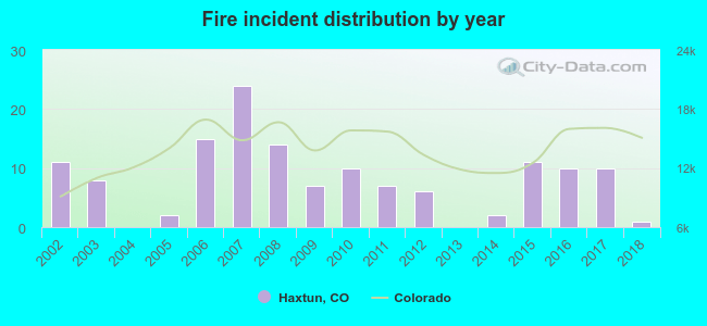 According to the data from the years 2002 - 2018 the average number of fires per year is 8. The highest number of reported fires - 24 took place in 2007, and the least - 0 in 2004. The data has a declining trend.
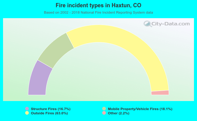 When looking into fire subcategories, the most incidents belonged to: Outside Fires (63.0%), and Mobile Property/Vehicle Fires (18.1%).
| Most common first names in Haxtun, CO among deceased individuals | ||
| Name | Count | Lived (average) |
|---|---|---|
| John | 18 | 80.3 years |
| Mary | 16 | 87.9 years |
| Harold | 12 | 78.6 years |
| Frank | 12 | 82.2 years |
| William | 11 | 76.7 years |
| Robert | 10 | 77.8 years |
| Hazel | 9 | 82.7 years |
| George | 8 | 78.8 years |
| Fred | 8 | 83.9 years |
| Edna | 8 | 83.6 years |
| Most common last names in Haxtun, CO among deceased individuals | ||
| Last name | Count | Lived (average) |
|---|---|---|
| Lambert | 12 | 76.9 years |
| Anderson | 11 | 83.7 years |
| Fetzer | 9 | 78.9 years |
| Baker | 9 | 79.2 years |
| Brown | 8 | 80.1 years |
| Harms | 8 | 85.1 years |
| Meakins | 7 | 84.7 years |
| Salyards | 7 | 78.3 years |
| Yost | 7 | 78.9 years |
| Koch | 7 | 80.3 years |
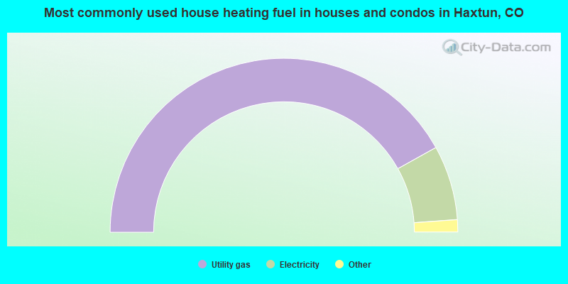
- 84.0%Utility gas
- 13.9%Electricity
- 1.2%No fuel used
- 0.9%Bottled, tank, or LP gas
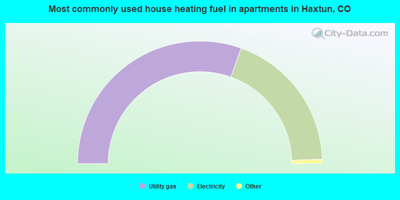
- 61.6%Utility gas
- 38.4%Electricity
Haxtun compared to Colorado state average:
- Median household income below state average.
- Median house value significantly below state average.
- Unemployed percentage significantly below state average.
- Black race population percentage significantly below state average.
- Hispanic race population percentage below state average.
- Median age above state average.
- Foreign-born population percentage significantly below state average.
- Renting percentage below state average.
- Length of stay since moving in significantly above state average.
- House age above state average.
Haxtun on our top lists:
- #28 on the list of "Top 100 high-educated but low-earning cities"
State forum archive:
- Colorado Pages: 2 3 4 5 6 7 8 9 10 11 12 13 14 15 16 17 18 19 20 21 22 23 24 25 26 27 28 29 30 31 32 33 34 35 36 37 38
- Boulder area Pages: 2 3 4 5 6 7 8 9
- Colorado Springs Pages: 2 3 4 5 6 7 8 9 10 11 12 13 14 15 16 17 18 19 20 21 22 23 24 25 26 27 28
- Denver Pages: 2 3 4 5 6 7 8 9 10 11 12 13 14 15 16 17 18 19 20 21 22 23 24 25 26 27 28 29 30 31 32 33 34 35 36 37 38 39 40 41 42 43 44 45 46 47 48 49 50 51 52 53 54 55 56 57 58 59 60 61 62 63 64 65 66 67 68 69
- Fort Collins area Pages: 2 3 4 5 6 7 8

|
Total of 3 patent applications in 2008-2024.