Headquarters, Kentucky
Submit your own pictures of this place and show them to the world
- OSM Map
- General Map
- Google Map
- MSN Map

| Males: 897 | |
| Females: 841 |
| Median resident age: | 37.5 years |
| Kentucky median age: | 35.9 years |
Zip code: 40311
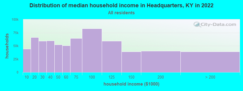
| Headquarters: | $46,088 |
| KY: | $59,341 |
Estimated per capita income in 2022: $19,806 (it was $12,552 in 2000)
Headquarters CCD income, earnings, and wages data
Estimated median house or condo value in 2022: $101,506 (it was $48,600 in 2000)
| Headquarters: | $101,506 |
| KY: | $196,300 |
Detailed information about poverty and poor residents in Headquarters, KY


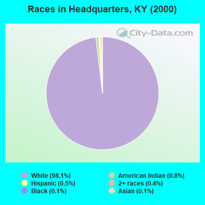
- 1,67298.1%White alone
- 130.8%American Indian alone
- 90.5%Hispanic
- 70.4%Two or more races
- 20.1%Black alone
- 20.1%Asian alone
Races in Headquarters detailed stats: ancestries, foreign born residents, place of birth
 Recent articles from our blog. Our writers, many of them Ph.D. graduates or candidates, create easy-to-read articles on a wide variety of topics.
Current Local Time: EST time zone
Land area: 90.2 square miles.
Population density: 19 people per square mile (very low).

| Headquarters CCD: | 0.5% ($232) |
| Kentucky: | 0.8% ($610) |
Nearest city with pop. 50,000+: Fayette, KY  (34.8 miles , pop. 260,512).
Nearest city with pop. 1,000,000+: Chicago, IL (307.1 miles , pop. 2,896,016).
Nearest cities:
), ), ), ), ), )Latitude: 38.38 N, Longitude: 84.04 W

| Here: | 3.8% |
| Kentucky: | 3.8% |
- Construction (11.3%)
- Educational services (9.3%)
- Agriculture, forestry, fishing & hunting (7.4%)
- Metal & metal products (7.0%)
- Transportation equipment (6.3%)
- Health care (5.7%)
- Chemicals (4.8%)
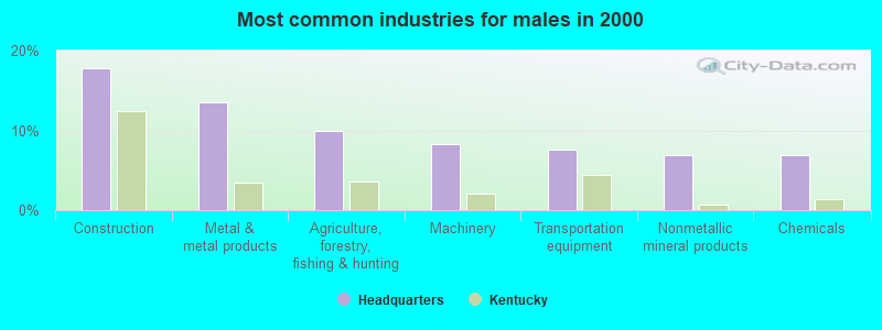
- Construction (17.8%)
- Metal & metal products (13.5%)
- Agriculture, forestry, fishing & hunting (9.9%)
- Machinery (8.3%)
- Transportation equipment (7.6%)
- Nonmetallic mineral products (6.9%)
- Chemicals (6.9%)
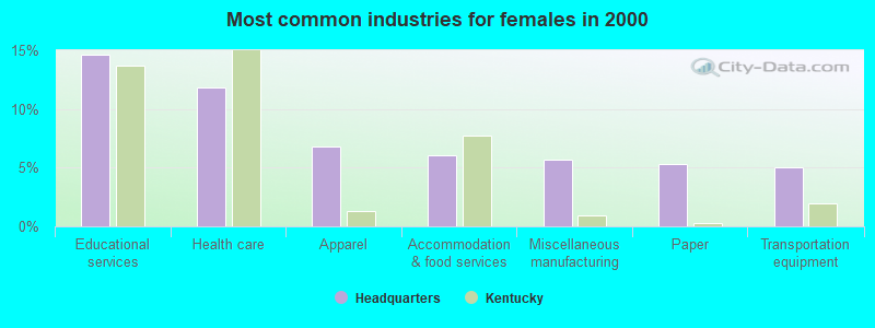
- Educational services (14.6%)
- Health care (11.8%)
- Apparel (6.8%)
- Accommodation & food services (6.1%)
- Miscellaneous manufacturing (5.7%)
- Paper (5.4%)
- Transportation equipment (5.0%)
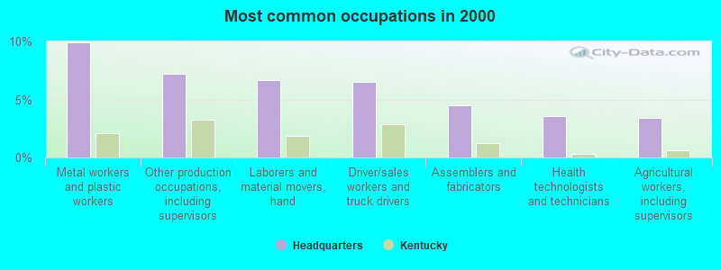
- Metal workers and plastic workers (9.9%)
- Other production occupations, including supervisors (7.2%)
- Laborers and material movers, hand (6.7%)
- Driver/sales workers and truck drivers (6.5%)
- Assemblers and fabricators (4.5%)
- Health technologists and technicians (3.6%)
- Agricultural workers, including supervisors (3.4%)
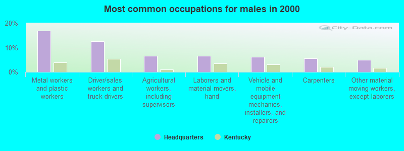
- Metal workers and plastic workers (16.8%)
- Driver/sales workers and truck drivers (12.5%)
- Agricultural workers, including supervisors (6.6%)
- Laborers and material movers, hand (6.6%)
- Vehicle and mobile equipment mechanics, installers, and repairers (6.3%)
- Carpenters (5.6%)
- Other material moving workers, except laborers (5.0%)
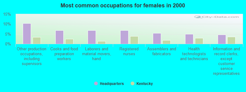
- Other production occupations, including supervisors (10.4%)
- Cooks and food preparation workers (6.8%)
- Laborers and material movers, hand (6.8%)
- Registered nurses (6.8%)
- Assemblers and fabricators (5.4%)
- Health technologists and technicians (5.0%)
- Information and record clerks, except customer service representatives (4.6%)
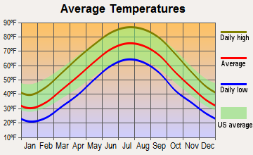
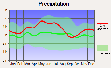
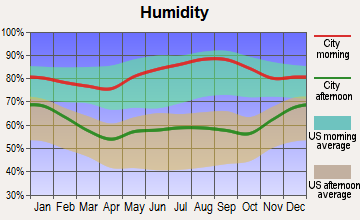
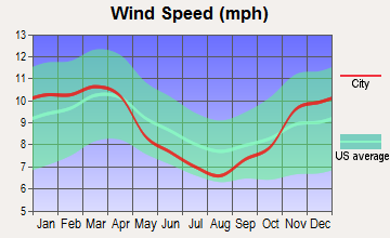
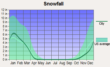
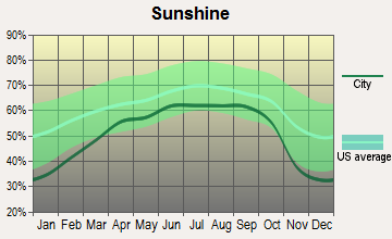
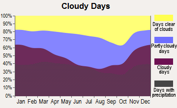
Average climate in Headquarters, Kentucky
Based on data reported by over 4,000 weather stations
Tornado activity:
Headquarters-area historical tornado activity is slightly below Kentucky state average. It is 13% greater than the overall U.S. average.
On 4/3/1974, a category F4 (max. wind speeds 207-260 mph) tornado 24.4 miles away from the Headquarters place center killed 7 people and injured 28 people.
On 4/3/1974, a category F4 tornado 26.7 miles away from the place center killed 4 people and injured 122 people and caused between $50,000 and $500,000 in damages.
Earthquake activity:
Headquarters-area historical earthquake activity is significantly above Kentucky state average. It is 51% greater than the overall U.S. average.On 7/27/1980 at 18:52:21, a magnitude 5.2 (5.1 MB, 4.7 MS, 5.0 UK, 5.2 UK, Class: Moderate, Intensity: VI - VII) earthquake occurred 13.2 miles away from Headquarters center
On 9/7/1988 at 02:28:09, a magnitude 4.6 (4.5 MB, 4.6 LG, Class: Light, Intensity: IV - V) earthquake occurred 18.6 miles away from Headquarters center
On 4/18/2008 at 09:36:59, a magnitude 5.4 (5.1 MB, 4.8 MS, 5.4 MW, 5.2 MW) earthquake occurred 208.6 miles away from Headquarters center
On 4/18/2008 at 09:36:59, a magnitude 5.2 (5.2 MW, Depth: 8.9 mi) earthquake occurred 208.6 miles away from Headquarters center
On 8/23/2011 at 17:51:04, a magnitude 5.8 (5.8 MW, Depth: 3.7 mi) earthquake occurred 333.4 miles away from Headquarters center
On 8/9/2020 at 12:07:37, a magnitude 5.1 (5.1 MW, Depth: 4.7 mi) earthquake occurred 208.6 miles away from Headquarters center
Magnitude types: regional Lg-wave magnitude (LG), body-wave magnitude (MB), surface-wave magnitude (MS), moment magnitude (MW)
Natural disasters:
The number of natural disasters in Nicholas County (23) is greater than the US average (15).Major Disasters (Presidential) Declared: 18
Emergencies Declared: 3
Causes of natural disasters: Floods: 15, Storms: 14, Tornadoes: 8, Mudslides: 7, Winter Storms: 6, Landslides: 5, Winds: 3, Blizzard: 1, Freeze: 1, Hurricane: 1, Snow: 1, Snowfall: 1, Snowstorm: 1, Other: 1 (Note: some incidents may be assigned to more than one category).
Hospitals and medical centers near Headquarters:
- NICHOLAS COUNTY HOSPITAL Critical Access Hospitals (about 5 miles away; CARLISLE, KY)
- NICHOLAS CO HOSP (Hospital, about 5 miles away; CARLISLE, KY)
- JOHNSON MATHERS NURSING HOME (Nursing Home, about 5 miles away; CARLISLE, KY)
- WEDCO DISTRICT HEALTH DEPARTMENT/HHA (Home Health Center, about 14 miles away; CYNTHIANA, KY)
- EDGEMONT HEALTHCARE (Nursing Home, about 14 miles away; CYNTHIANA, KY)
- BOURBON COMMUNITY HOSPITAL Acute Care Hospitals (about 16 miles away; PARIS, KY)
- PIONEER TRACE NURSING HOME (Nursing Home, about 16 miles away; FLEMINGSBURG, KY)
Colleges/universities with over 2000 students nearest to Headquarters:
- Maysville Community and Technical College (about 22 miles; Maysville, KY; Full-time enrollment: 2,969)
- University of Kentucky (about 36 miles; Lexington, KY; FT enrollment: 23,517)
- Bluegrass Community and Technical College (about 36 miles; Lexington, KY; FT enrollment: 8,560)
- Morehead State University (about 36 miles; Morehead, KY; FT enrollment: 7,523)
- Kentucky State University (about 47 miles; Frankfort, KY; FT enrollment: 2,112)
- Eastern Kentucky University (about 47 miles; Richmond, KY; FT enrollment: 13,525)
- University of Cincinnati-Clermont College (about 50 miles; Batavia, OH; FT enrollment: 2,739)
Points of interest:
Notable locations in Headquarters: Blue Licks Spring (A), Salt Well (B), Walnut Grove (C), Lower Blue Licks (D), Hogjaws (E), Masonic Lodge Hall (F). Display/hide their locations on the map
Churches in Headquarters include: Hildreth Church (A), Ishmael Church (B), Needmore Church (C), Oakland Mills Church (D), Stony Creek Church (E), Ball Hill Church (F), Rose Hill Church (G), Daton Chapel (H). Display/hide their locations on the map
Cemeteries: Standiford Cemetery (1), Needmore Church Cemetery (2), Herndon Cemetery (3), Rose Hill Church Cemetery (4), Rankin Cemetery (5), Mount Carmel Cemetery (6), Salt Well Cemetery (7). Display/hide their locations on the map
Streams, rivers, and creeks: West Branch Sugar Creek (A), Crooked Creek (B), Stony Creek (C), Buchanan Creek (D), Plank Run (E), Painter Creek (F), Mint Creek (G), Goose Creek (H), Fleming Creek (I). Display/hide their locations on the map
| This place: | 2.6 people |
| Kentucky: | 2.5 people |
| This place: | 70.9% |
| Whole state: | 66.9% |
| This place: | 8.7% |
| Whole state: | 6.4% |
Likely homosexual households (counted as self-reported same-sex unmarried-partner households)
- Lesbian couples: 0.5% of all households
- Gay men: 0.4% of all households
| This place: | 22.4% |
| Whole state: | 15.8% |
| This place: | 7.3% |
| Whole state: | 6.6% |
For population 15 years and over in Headquarters:
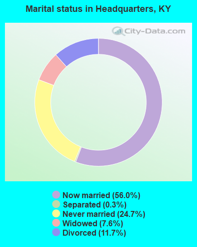
- Never married: 24.7%
- Now married: 56.0%
- Separated: 0.3%
- Widowed: 7.6%
- Divorced: 11.7%
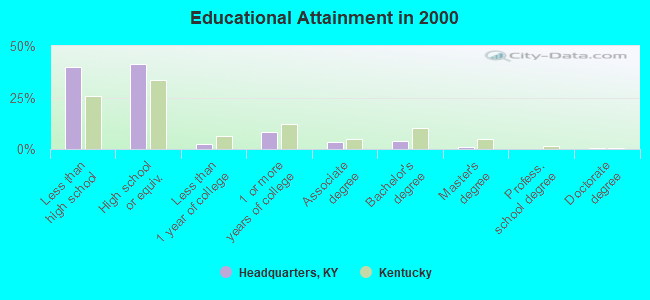
For population 25 years and over in Headquarters:
- High school or higher: 60.3%
- Bachelor's degree or higher: 5.2%
- Graduate or professional degree: 1.4%
- Unemployed: 21.8%
- Mean travel time to work (commute): 36.9 minutes
| Here: | 12.6 |
| Kentucky average: | 13.8 |
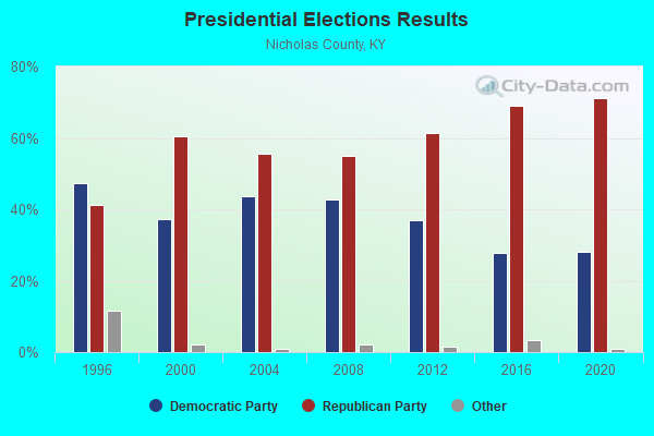
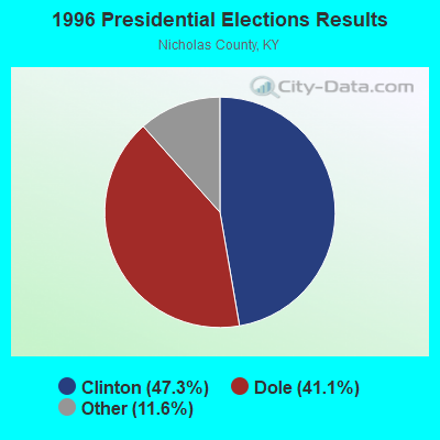
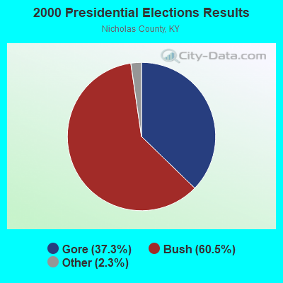
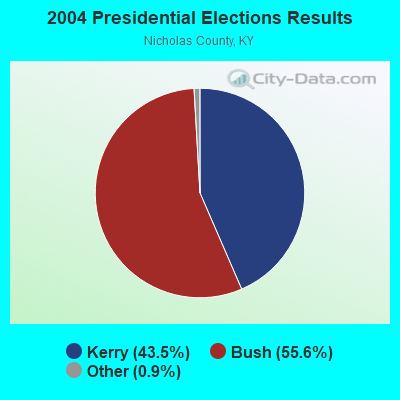
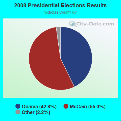
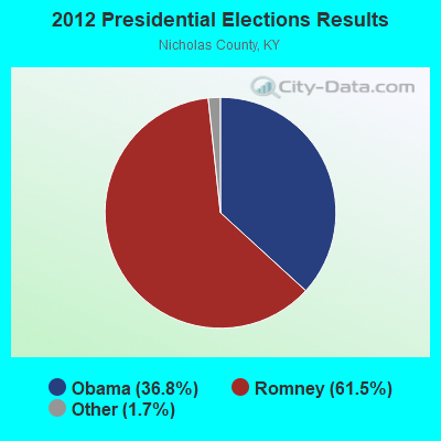
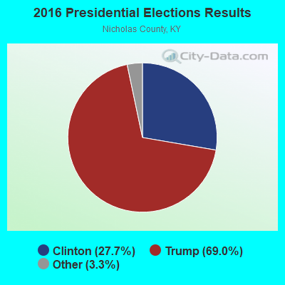
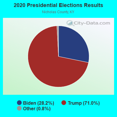
Graphs represent county-level data. Detailed 2008 Election Results
Religion statistics for Headquarters, KY (based on Nicholas County data)
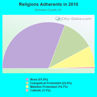
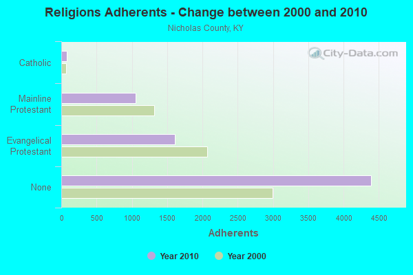
| Religion | Adherents | Congregations |
|---|---|---|
| Evangelical Protestant | 1,611 | 11 |
| Mainline Protestant | 1,052 | 11 |
| Catholic | 78 | 1 |
| Other | 1 | - |
| None | 4,393 | - |
Food Environment Statistics:
| Here: | 1.46 / 10,000 pop. |
| State: | 2.19 / 10,000 pop. |
| Nicholas County: | 2.92 / 10,000 pop. |
| Kentucky: | 0.74 / 10,000 pop. |
| This county: | 2.92 / 10,000 pop. |
| State: | 4.36 / 10,000 pop. |
| Nicholas County: | 7.29 / 10,000 pop. |
| State: | 5.74 / 10,000 pop. |
| Here: | 11.9% |
| State: | 11.0% |
| Here: | 33.5% |
| Kentucky: | 30.0% |
| This county: | 8.6% |
| Kentucky: | 15.9% |
Strongest AM radio stations in Headquarters:
- WLW (700 AM; 50 kW; CINCINNATI, OH; Owner: JACOR BROADCASTING CORPORATION)
- WSAI (1530 AM; 50 kW; CINCINNATI, OH; Owner: JACOR BROADCASTING CORPORATION)
- WHAS (840 AM; 50 kW; LOUISVILLE, KY; Owner: CLEAR CHANNEL BROADCASTING LICENSES, INC.)
- WLAP (630 AM; 5 kW; LEXINGTON, KY; Owner: CITICASTERS LICENSES, L.P.)
- WTVN (610 AM; 50 kW; COLUMBUS, OH; Owner: CITICASTERS LICENSES, L.P.)
- WVLK (590 AM; 5 kW; LEXINGTON, KY; Owner: CUMULUS LICENSING CORP.)
- WXRA (1580 AM; 10 kW; GEORGETOWN, KY; Owner: CITICASTERS LICENSES, L.P.)
- WCYN (1400 AM; 1 kW; CYNTHIANA, KY; Owner: WCYN RADIO, INC.)
- WKRC (550 AM; 5 kW; CINCINNATI, OH; Owner: JACOR BROADCASTING CORPORATION)
- WYGH (1440 AM; 1 kW; PARIS, KY; Owner: HAMMOND BROADCASTING, INC.)
- WMJR (1380 AM; 2 kW; WINCHESTER, KY; Owner: THY KINGDOM COME NETWORK, INC)
- WKVL (850 AM; daytime; 50 kW; KNOXVILLE, TN; Owner: HORNE RADIO, LLC)
- WLXG (1300 AM; 2 kW; LEXINGTON, KY; Owner: L.M. COMMUNICATIONS, INC)
Strongest FM radio stations in Headquarters:
- WBVX (92.1 FM; CARLISLE, KY; Owner: L.M. COMMUNICATIONS OF KENTUCKY, LLC)
- WCYN-FM (102.3 FM; CYNTHIANA, KY; Owner: CUMULUS LICENSING CORP.)
- WIOK (107.5 FM; FALMOUTH, KY; Owner: HAMMOND BROADCASTING, INC.)
- WAOL (99.5 FM; RIPLEY, OH; Owner: RICHARD L. PLESSINGER, SR.)
- WVLK-FM (92.9 FM; LEXINGTON, KY; Owner: CUMULUS LICENSING CORP.)
- WUKY (91.3 FM; LEXINGTON, KY; Owner: BD. OF TRUSTEES UNIV. OF KENTUCKY)
- WMXL (94.5 FM; LEXINGTON, KY; Owner: CITICASTERS LICENSES, INC.)
- WKQQ (100.1 FM; WINCHESTER, KY; Owner: CITICASTERS LICENSES, L.P.)
- WMKY (90.3 FM; MOREHEAD, KY; Owner: MOREHEAD STATE UNIVERSITY)
- WMKJ (105.5 FM; MOUNT STERLING, KY; Owner: CITICASTERS LICENSES, INC.)
- WFLE-FM (95.1 FM; FLEMINGSBURG, KY; Owner: FLEMING COUNTY BROADCASTING CO., INC)
- WKCA (107.7 FM; OWINGSVILLE, KY; Owner: GATEWAY RADIO WORKS, INC.)
- WGKS (96.9 FM; PARIS, KY; Owner: L.M. COMMUNICATIONS, INC.)
- WLKT (104.5 FM; LEXINGTON-FAYETTE, KY; Owner: CITICASTERS LICENSES, L.P.)
- WXZZ (103.3 FM; GEORGETOWN, KY; Owner: CUMULUS LICENSING CORP.)
- WBUL-FM (98.1 FM; LEXINGTON, KY; Owner: CITICASTERS LICENSES, L.P.)
- WFTM-FM (95.9 FM; MAYSVILLE, KY; Owner: STANDARD TOBACCO COMPANY, INC.)
- WAGX (101.3 FM; MANCHESTER, OH; Owner: JEWELL SCHAEFFER BROADCASTING CO.)
TV broadcast stations around Headquarters:
- WKYT-TV (Channel 27; LEXINGTON, KY; Owner: WKYT LICENSEE CORP.)
- WUPX-TV (Channel 67; MOREHEAD, KY; Owner: PAXSON LEXINGTON LICENSE, INC.)
- WTVQ-TV (Channel 36; LEXINGTON, KY; Owner: MEDIA GENERAL COMMUNICATIONS, INC.)
- WLEX-TV (Channel 18; LEXINGTON, KY; Owner: WLEX COMMUNICATIONS, L.L.C.)
- WKLE (Channel 46; LEXINGTON, KY; Owner: KENTUCKY AUTHORITY FOR EDUCATIONAL TV)
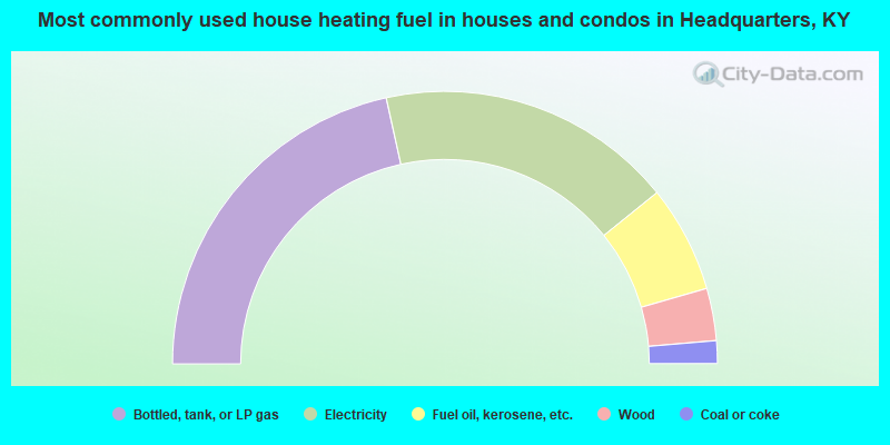
- 43.1%Bottled, tank, or LP gas
- 35.3%Electricity
- 12.7%Fuel oil, kerosene, etc.
- 6.2%Wood
- 2.7%Coal or coke
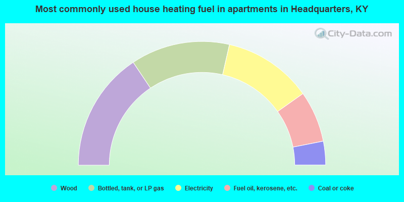
- 31.2%Wood
- 25.9%Bottled, tank, or LP gas
- 23.2%Electricity
- 13.4%Fuel oil, kerosene, etc.
- 6.2%Coal or coke
Headquarters compared to Kentucky state average:
- Median house value below state average.
- Black race population percentage significantly below state average.
- Hispanic race population percentage significantly below state average.
- Foreign-born population percentage significantly below state average.
- Renting percentage below state average.
- Length of stay since moving in significantly above state average.
- Number of rooms per house significantly below state average.
- House age significantly below state average.
- Number of college students below state average.
- Percentage of population with a bachelor's degree or higher significantly below state average.