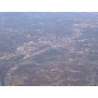
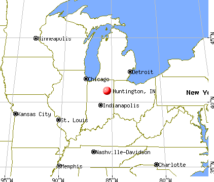
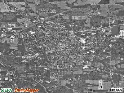
Huntington, Indiana

Submit your own pictures of this city and show them to the world
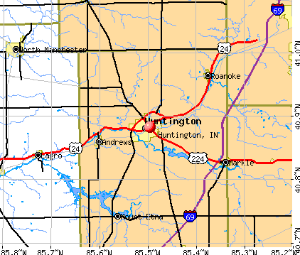
- OSM Map
- General Map
- Google Map
- MSN Map
Population change since 2000: -2.4%
 |
| Males: 8,145 | |
| Females: 8,878 |
| Median resident age: | 36.8 years |
| Indiana median age: | 38.2 years |
Zip codes: 46750.
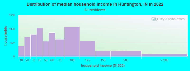
| Huntington: | $50,455 |
| IN: | $66,785 |
Estimated per capita income in 2022: $25,945 (it was $18,242 in 2000)
Huntington city income, earnings, and wages data
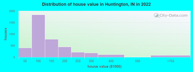
Estimated median house or condo value in 2022: $107,987 (it was $69,900 in 2000)
| Huntington: | $107,987 |
| IN: | $208,700 |
Mean prices in 2022: all housing units: $139,610; detached houses: $141,661; townhouses or other attached units: $221,713; in 2-unit structures: $99,303; mobile homes: $14,049
Median gross rent in 2022: $754.
(15.9% for White Non-Hispanic residents, 25.6% for Black residents, 33.5% for Hispanic or Latino residents, 100.0% for Native Hawaiian and other Pacific Islander residents, 31.9% for other race residents, 35.2% for two or more races residents)
Detailed information about poverty and poor residents in Huntington, IN


Compare current foreclosures in Huntington, IN:
| Photo | Address | Area | Beds / Baths | Price | Details |
|---|---|---|---|---|---|

|
#1
N 200 W
Huntington, IN 46750
|
2,330 sq. feet
|
2 baths 4 beds |
show details | |

|
#2
S 600 W
Huntington, IN 46750
|
1,440 sq. feet
|
2 baths 3 beds |
show details | |

|
#3
E Taylor St
Huntington, IN 46750
|
1,616 sq. feet
|
1 baths 3 beds |
show details | |

|
#4
W 800 N
Huntington, IN 46750
|
910 sq. feet
|
1 baths 3 beds |
show details | |

|
#5
N 635 W
Huntington, IN 46750
|
1,262 sq. feet
|
1 baths 3 beds |
show details | |

|
#6
Buchannan St
Huntington, IN 46750
|
2,030 sq. feet
|
1 baths 3 beds |
show details | |

|
#7
Northway Dr
Huntington, IN 46750
|
2,127 sq. feet
|
2 baths 3 beds |
show details | |

|
#8
Mayne St
Huntington, IN 46750
|
1,048 sq. feet
|
1 baths 2 beds |
show details | |

|
#9
Canterbury Ct
Huntington, IN 46750
|
1,834 sq. feet
|
2 baths 4 beds |
show details | |

|
#10
Buchannan St
Huntington, IN 46750
|
1,444 sq. feet
|
1 baths 3 beds |
show details |
| Photo | Address | Area | Beds / Baths | Price | Details |
|---|---|---|---|---|---|

|
#11
Guilford St
Huntington, IN 46750
|
2,542 sq. feet
|
1 baths 4 beds |
show details | |

|
#12
Swan St
Huntington, IN 46750
|
1,372 sq. feet
|
1 baths 3 beds |
show details | |

|
#13
Henry St
Huntington, IN 46750
|
1,992 sq. feet
|
1 baths 3 beds |
show details | |

|
#14
E Franklin St
Huntington, IN 46750
|
1,908 sq. feet
|
2 baths 2 beds |
show details | |

|
#15
Vine St
Huntington, IN 46750
|
1,350 sq. feet
|
1 baths 4 beds |
show details | |

|
#16
N 300 W
Huntington, IN 46750
|
1,690 sq. feet
|
1 baths 3 beds |
show details | |

|
#17
W 700 N
Huntington, IN 46750
|
2,036 sq. feet
|
1 baths 4 beds |
show details | |

|
#18
W 700 N
Huntington, IN 46750
|
1,560 sq. feet
|
2 baths 3 beds |
show details | |

|
#19
William St
Huntington, IN 46750
|
816 sq. feet
|
1 baths 2 beds |
show details | |

|
#20
Poplar St
Huntington, IN 46750
|
1,512 sq. feet
|
1 baths 2 beds |
show details |
| Photo | Address | Area | Beds / Baths | Price | Details |
|---|---|---|---|---|---|

|
#21
Himes St
Huntington, IN 46750
|
832 sq. feet
|
1 baths 2 beds |
show details | |

|
#22
N 324 W
Huntington, IN 46750
|
1,472 sq. feet
|
2 baths 3 beds |
show details | |

|
#23
Salamonie Ave
Huntington, IN 46750
|
1,716 sq. feet
|
1 baths 2 beds |
show details | |

|
#24
George St
Huntington, IN 46750
|
1,600 sq. feet
|
2 baths 4 beds |
show details | |

|
#25
Guilford St
Huntington, IN 46750
|
1,644 sq. feet
|
1 baths 4 beds |
show details | |

|
#26
E 722 N
Huntington, IN 46750
|
1,500 sq. feet
|
2 baths 3 beds |
show details | |

|
#27
S Broadway St
Huntington, IN 46750
|
1,540 sq. feet
|
1 baths 3 beds |
show details | |

|
#28
Hauenstein Rd Apt 8
Huntington, IN 46750
|
- sq. feet
|
- baths - beds |
show details | |

|
#29
Ogan Ave
Huntington, IN 46750
|
- sq. feet
|
- baths - beds |
show details | |

|
#30
E Franklin St
Huntington, IN 46750
|
- sq. feet
|
- baths - beds |
show details |
| Photo | Address | Area | Beds / Baths | Price | Details |
|---|---|---|---|---|---|

|
#31
Court St
Huntington, IN 46750
|
- sq. feet
|
- baths - beds |
show details | |

|
#32
E High St
Huntington, IN 46750
|
- sq. feet
|
- baths - beds |
show details | |

|
#33
E Washington St
Huntington, IN 46750
|
- sq. feet
|
- baths - beds |
show details | |

|
#34
N Jefferson St
Huntington, IN 46750
|
- sq. feet
|
- baths - beds |
show details | |

|
#35
Memorial Ln Apt C
Huntington, IN 46750
|
- sq. feet
|
- baths - beds |
show details | |

|
#36
Fruit St
Huntington, IN 46750
|
- sq. feet
|
- baths - beds |
show details | |

|
#37
Arbor Ln
Huntington, IN 46750
|
- sq. feet
|
- baths - beds |
show details | |

|
#38
Hauenstein Rd Apt 3
Huntington, IN 46750
|
- sq. feet
|
- baths - beds |
show details | |

|
#39
College Ave
Huntington, IN 46750
|
- sq. feet
|
- baths - beds |
show details | |

|
#40
E 100 S
Huntington, IN 46750
|
- sq. feet
|
- baths - beds |
show details |
| Photo | Address | Area | Beds / Baths | Price | Details |
|---|---|---|---|---|---|

|
#41
S Jefferson St
Huntington, IN 46750
|
- sq. feet
|
- baths - beds |
show details | |

|
#42
W Division Rd
Huntington, IN 46750
|
- sq. feet
|
- baths - beds |
show details | |

|
Check over 1 million property listings on Foreclosure.com!
|
browse all offers | |||


- 15,56290.8%White alone
- 5663.3%Hispanic
- 3151.8%Two or more races
- 2271.3%Asian alone
- 2101.2%Black alone
- 660.4%Other race alone
- 380.2%Native Hawaiian and Other
Pacific Islander alone - 170.10%American Indian alone
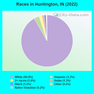
Races in Huntington detailed stats: ancestries, foreign born residents, place of birth
According to our research of Indiana and other state lists, there were 2 registered sex offenders living in Huntington, Indiana as of April 27, 2024.
The ratio of all residents to sex offenders in Huntington is 8,727 to 1.
The ratio of registered sex offenders to all residents in this city is much lower than the state average.
Type |
2009 |
2010 |
2011 |
2012 |
2013 |
2014 |
2015 |
2017 |
2018 |
2020 |
2021 |
2022 |
|---|---|---|---|---|---|---|---|---|---|---|---|---|
| Murders (per 100,000) | 0 (0.0) | 0 (0.0) | 0 (0.0) | 0 (0.0) | 0 (0.0) | 0 (0.0) | 0 (0.0) | 1 (5.8) | 1 (5.9) | 0 (0.0) | 0 (0.0) | 4 (23.5) |
| Rapes (per 100,000) | 7 (42.6) | 2 (11.5) | 5 (28.6) | 10 (57.2) | 8 (46.3) | 6 (34.9) | 4 (23.4) | 6 (35.1) | 1 (5.9) | 4 (23.4) | 5 (29.4) | 2 (11.7) |
| Robberies (per 100,000) | 4 (24.4) | 1 (5.8) | 2 (11.4) | 4 (22.9) | 3 (17.4) | 0 (0.0) | 0 (0.0) | 0 (0.0) | 2 (11.8) | 1 (5.8) | 0 (0.0) | 2 (11.7) |
| Assaults (per 100,000) | 14 (85.2) | 18 (103.5) | 5 (28.6) | 17 (97.2) | 16 (92.6) | 14 (81.5) | 10 (58.4) | 7 (40.9) | 2 (11.8) | 4 (23.4) | 5 (29.4) | 4 (23.5) |
| Burglaries (per 100,000) | 77 (468.8) | 76 (437.0) | 66 (377.6) | 65 (371.7) | 60 (347.4) | 43 (250.4) | 31 (181.1) | 20 (116.8) | 20 (117.5) | 45 (263.2) | 28 (164.6) | 17 (99.8) |
| Thefts (per 100,000) | 274 (1,668) | 277 (1,593) | 395 (2,260) | 388 (2,219) | 304 (1,760) | 257 (1,496) | 194 (1,133) | 108 (631.0) | 74 (434.8) | 195 (1,141) | 142 (835.0) | 165 (968.9) |
| Auto thefts (per 100,000) | 11 (67.0) | 13 (74.8) | 17 (97.3) | 14 (80.1) | 9 (52.1) | 8 (46.6) | 11 (64.3) | 7 (40.9) | 7 (41.1) | 12 (70.2) | 11 (64.7) | 6 (35.2) |
| Arson (per 100,000) | 1 (6.1) | 7 (40.3) | 8 (45.8) | 3 (17.2) | 2 (11.6) | 2 (11.6) | 9 (52.6) | 0 (0.0) | 0 (0.0) | 0 (0.0) | 0 (0.0) | 2 (11.7) |
| City-Data.com crime index | 163.4 | 131.9 | 156.6 | 193.2 | 159.7 | 125.4 | 93.5 | 84.6 | 51.2 | 94.8 | 79.5 | 113.2 |
The City-Data.com crime index weighs serious crimes and violent crimes more heavily. Higher means more crime, U.S. average is 246.1. It adjusts for the number of visitors and daily workers commuting into cities.
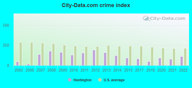
Crime rate in Huntington detailed stats: murders, rapes, robberies, assaults, burglaries, thefts, arson
Full-time law enforcement employees in 2021, including police officers: 38 (35 officers - 34 male; 1 female).
| Officers per 1,000 residents here: | 2.06 |
| Indiana average: | 2.16 |
 Recent articles from our blog. Our writers, many of them Ph.D. graduates or candidates, create easy-to-read articles on a wide variety of topics.

 | Huntington, anyone? (1 reply) |
| Is Huntington safe? (6 replies) |
| Greencastle Up and Coming? (17 replies) |
| Cougars, Wolves, Bears, Bobcats in Indiana (55 replies) |
| Thoughts on Wabash, Indiana? (17 replies) |
| Is finding a rental impossible? (5 replies) |
Latest news from Huntington, IN collected exclusively by city-data.com from local newspapers, TV, and radio stations
Ancestries: German (27.8%), American (17.1%), English (13.7%), Irish (7.9%), European (2.4%), Dutch (1.4%).
Current Local Time: EST time zone
Elevation: 743 feet
Land area: 8.35 square miles.
Population density: 2,040 people per square mile (low).
424 residents are foreign born (1.1% Asia, 0.8% Latin America, 0.3% Africa).
| This city: | 2.5% |
| Indiana: | 5.6% |
Median real estate property taxes paid for housing units with mortgages in 2022: $890 (0.8%)
Median real estate property taxes paid for housing units with no mortgage in 2022: $865 (0.9%)
Nearest city with pop. 50,000+: Fort Wayne, IN  (23.6 miles , pop. 205,727).
Nearest city with pop. 1,000,000+: Chicago, IL (131.3 miles , pop. 2,896,016).
Nearest cities:
), Latitude: 40.88 N, Longitude: 85.50 W
Daytime population change due to commuting: +1,489 (+8.7%)
Workers who live and work in this city: 4,217 (54.1%)
Area code: 260
Huntington, Indiana accommodation & food services, waste management - Economy and Business Data
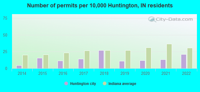
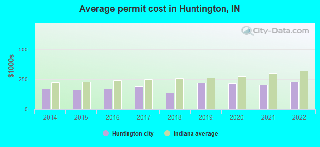
Single-family new house construction building permits:
- 2022: 37 buildings, average cost: $227,900
- 2021: 23 buildings, average cost: $206,800
- 2020: 21 buildings, average cost: $216,300
- 2019: 19 buildings, average cost: $222,100
- 2018: 47 buildings, average cost: $141,300
- 2017: 25 buildings, average cost: $194,200
- 2016: 20 buildings, average cost: $174,100
- 2015: 27 buildings, average cost: $163,500
- 2014: 8 buildings, average cost: $170,500
| Here: | 2.5% |
| Indiana: | 2.8% |
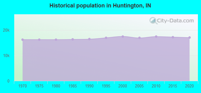
Population change in the 1990s: +352 (+2.1%).
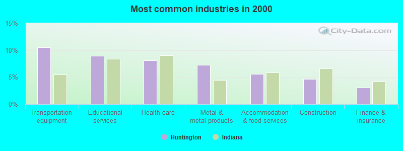
- Transportation equipment (10.5%)
- Educational services (8.9%)
- Health care (8.1%)
- Metal & metal products (7.3%)
- Accommodation & food services (5.6%)
- Construction (4.6%)
- Finance & insurance (3.0%)
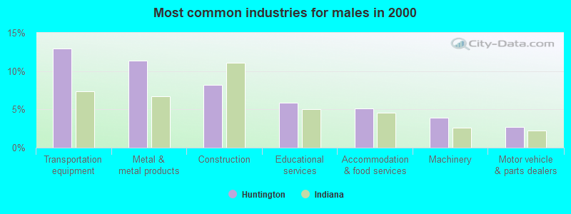
- Transportation equipment (13.0%)
- Metal & metal products (11.3%)
- Construction (8.2%)
- Educational services (5.9%)
- Accommodation & food services (5.1%)
- Machinery (3.9%)
- Motor vehicle & parts dealers (2.7%)
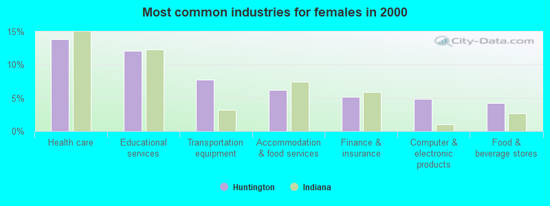
- Health care (13.9%)
- Educational services (12.1%)
- Transportation equipment (7.8%)
- Accommodation & food services (6.2%)
- Finance & insurance (5.1%)
- Computer & electronic products (4.8%)
- Food & beverage stores (4.3%)
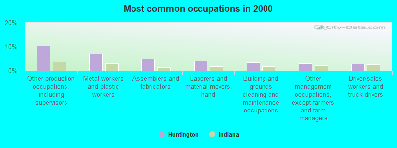
- Other production occupations, including supervisors (10.3%)
- Metal workers and plastic workers (7.1%)
- Assemblers and fabricators (4.9%)
- Laborers and material movers, hand (4.1%)
- Building and grounds cleaning and maintenance occupations (3.5%)
- Other management occupations, except farmers and farm managers (3.0%)
- Driver/sales workers and truck drivers (2.8%)
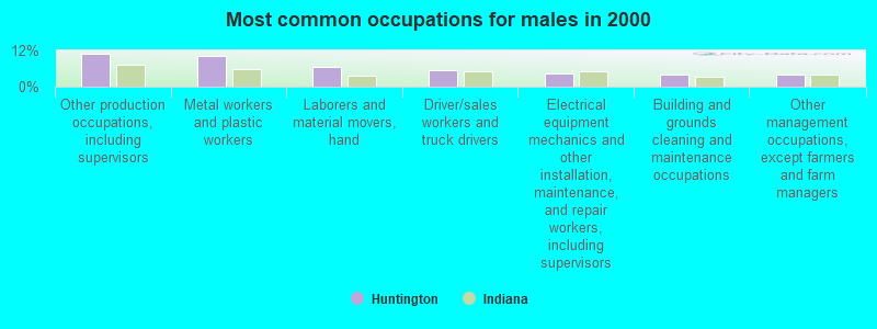
- Other production occupations, including supervisors (10.9%)
- Metal workers and plastic workers (10.3%)
- Laborers and material movers, hand (6.5%)
- Driver/sales workers and truck drivers (5.4%)
- Electrical equipment mechanics and other installation, maintenance, and repair workers, including supervisors (4.3%)
- Building and grounds cleaning and maintenance occupations (3.9%)
- Other management occupations, except farmers and farm managers (3.8%)
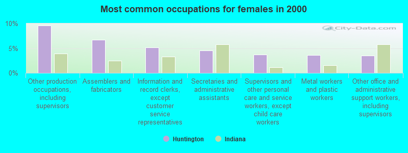
- Other production occupations, including supervisors (9.6%)
- Assemblers and fabricators (6.7%)
- Information and record clerks, except customer service representatives (5.2%)
- Secretaries and administrative assistants (4.5%)
- Supervisors and other personal care and service workers, except child care workers (3.7%)
- Metal workers and plastic workers (3.6%)
- Other office and administrative support workers, including supervisors (3.5%)
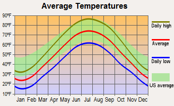
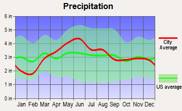
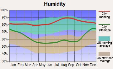
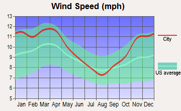
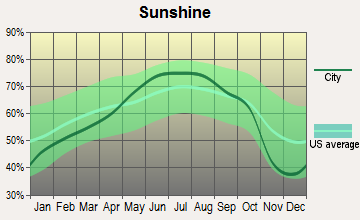
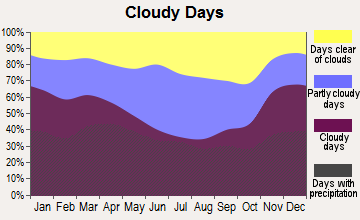
Average climate in Huntington, Indiana
Based on data reported by over 4,000 weather stations

|
|

(lower is better)
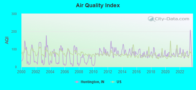
Air Quality Index (AQI) level in 2023 was 101. This is worse than average.
| City: | 101 |
| U.S.: | 73 |
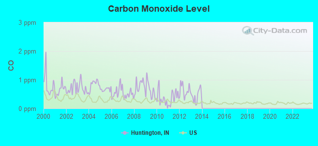
Carbon Monoxide (CO) [ppm] level in 2013 was 0.447. This is significantly worse than average. Closest monitor was 23.0 miles away from the city center.
| City: | 0.447 |
| U.S.: | 0.251 |
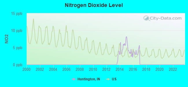
Nitrogen Dioxide (NO2) [ppb] level in 2016 was 3.82. This is better than average. Closest monitor was 12.8 miles away from the city center.
| City: | 3.82 |
| U.S.: | 5.11 |
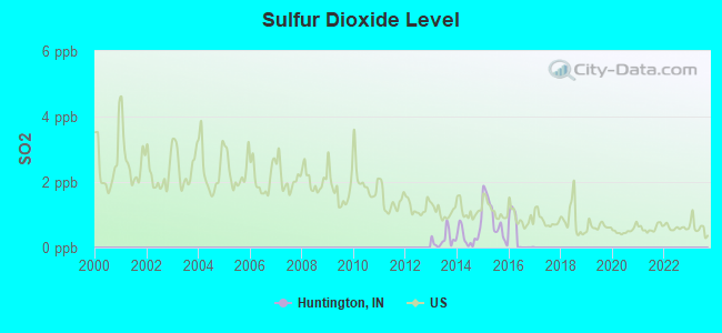
Sulfur Dioxide (SO2) [ppb] level in 2016 was 0.373. This is significantly better than average. Closest monitor was 21.1 miles away from the city center.
| City: | 0.373 |
| U.S.: | 1.515 |
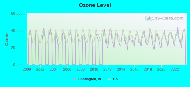
Ozone [ppb] level in 2023 was 35.3. This is about average. Closest monitor was 8.1 miles away from the city center.
| City: | 35.3 |
| U.S.: | 33.3 |
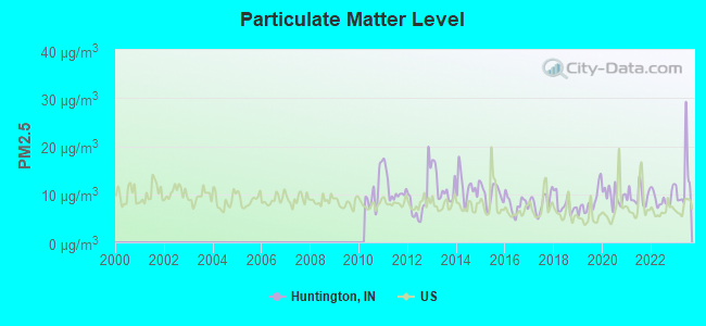
Particulate Matter (PM2.5) [µg/m3] level in 2023 was 12.6. This is significantly worse than average. Closest monitor was 21.1 miles away from the city center.
| City: | 12.6 |
| U.S.: | 8.1 |
Tornado activity:
Huntington-area historical tornado activity is near Indiana state average. It is 94% greater than the overall U.S. average.
On 3/6/1956, a category F4 (max. wind speeds 207-260 mph) tornado 20.3 miles away from the Huntington city center killed one person and injured 31 people and caused between $500,000 and $5,000,000 in damages.
On 4/11/1965, a category F4 tornado 23.8 miles away from the city center killed 4 people and injured 125 people and caused between $5,000,000 and $50,000,000 in damages.
Earthquake activity:
Huntington-area historical earthquake activity is significantly above Indiana state average. It is 12% greater than the overall U.S. average.On 4/18/2008 at 09:36:59, a magnitude 5.4 (5.1 MB, 4.8 MS, 5.4 MW, 5.2 MW, Class: Moderate, Intensity: VI - VII) earthquake occurred 210.8 miles away from the city center
On 7/27/1980 at 18:52:21, a magnitude 5.2 (5.1 MB, 4.7 MS, 5.0 UK, 5.2 UK) earthquake occurred 202.8 miles away from Huntington center
On 7/12/1986 at 08:19:37, a magnitude 4.5 (4.5 MB, Class: Light, Intensity: IV - V) earthquake occurred 63.6 miles away from Huntington center
On 6/10/1987 at 23:48:54, a magnitude 5.1 (4.9 MB, 4.4 MS, 4.6 MS, 5.1 LG) earthquake occurred 190.8 miles away from Huntington center
On 4/18/2008 at 09:36:59, a magnitude 5.2 (5.2 MW, Depth: 8.9 mi) earthquake occurred 210.8 miles away from Huntington center
On 1/31/1986 at 16:46:43, a magnitude 5.0 (5.0 MB) earthquake occurred 230.9 miles away from the city center
Magnitude types: regional Lg-wave magnitude (LG), body-wave magnitude (MB), surface-wave magnitude (MS), moment magnitude (MW)
Natural disasters:
The number of natural disasters in Huntington County (13) is near the US average (15).Major Disasters (Presidential) Declared: 8
Emergencies Declared: 4
Causes of natural disasters: Floods: 6, Storms: 5, Winter Storms: 4, Tornadoes: 3, Hurricane: 1, Snow: 1, Snowstorm: 1, Other: 1 (Note: some incidents may be assigned to more than one category).
Hospitals in Huntington:
- PARKVIEW HOME HEALTH AND HOSPICE (240 S JEFFERSON STREET SUITE C)
- PARKVIEW HUNTINGTON HOSPITAL (Voluntary non-profit - Private, provides emergency services, 2001 STULTS RD)
- PATHFINDER SERVICES INC (1135 E TIPTON ST)
- PATHFINDER SERVICES INC (317 E FRANKLIN ST)
Nursing Homes in Huntington:
- COMMUNITY CARE CENTER OF HUNTINGTON (850 ASH STREET)
- HERITAGE OF HUNTINGTON (1180 W 500 N)
- HICKORY CREEK AT HUNTINGTON (1425 GRANT ST)
- MILLER S MERRY MANOR INC (1500 GRANT STREET)
- MILLER'S MERRY MANOR (1500 GRANT ST)
- NORWOOD HEALTH AND REHABILITATION CENTER (3720 N NORWOOD RD)
- NORWOOD NURSING CENTER (3720 NORTH NORWOOD ROAD)
- OAKBROOK VILLAGE (850 ASH ST)
Dialysis Facilities in Huntington:
Airports and heliports located in Huntington:
- Huntington Municipal Airport (HHG) (Runways: 1, Air Taxi Ops: 79, Itinerant Ops: 2,529, Local Ops: 5,296)
- Beck Pvt Airport (II14) (Runways: 1)
- Bowlin Airport (IN85) (Runways: 1)
- Parkview Huntington Hospital Heliport (80IN)
College/University in Huntington:
Colleges/universities with over 2000 students nearest to Huntington:
- University of Saint Francis-Fort Wayne (about 23 miles; Fort Wayne, IN; Full-time enrollment: 2,075)
- Indiana Institute of Technology (about 24 miles; Fort Wayne, IN; FT enrollment: 4,320)
- Indiana University-Purdue University-Fort Wayne (about 26 miles; Fort Wayne, IN; FT enrollment: 10,126)
- Indiana Wesleyan University (about 27 miles; Marion, IN; FT enrollment: 13,681)
- Taylor University (about 30 miles; Upland, IN; FT enrollment: 2,272)
- Indiana University-Kokomo (about 45 miles; Kokomo, IN; FT enrollment: 2,500)
- Ball State University (about 48 miles; Muncie, IN; FT enrollment: 20,254)
Public high school in Huntington:
- HUNTINGTON NORTH HIGH SCHOOL (Students: 1,937, Location: 450 MACGAHAN ST, Grades: 9-12)
Public elementary/middle schools in Huntington:
- CRESTVIEW MIDDLE SCHOOL (Students: 667, Location: 1151 W 500 N, Grades: 6-8)
- RIVERVIEW SCHOOL (Students: 589, Location: 2465 WATERWORKS RD, Grades: 6-8)
- FLINT SPRINGS ELEMENTARY (Students: 520, Location: 1360 E TIPTON ST, Grades: KG-5)
- NORTHWEST ELEMENTARY SCHOOL (Students: 351, Location: 4524 W 800 N, Grades: KG-5)
- LANCASTER ELEMENTARY SCHOOL (Students: 228, Location: 2932 W 300 S, Grades: KG-5)
- LINCOLN ELEMENTARY SCHOOL (Location: 2037 E TAYLOR ST, Grades: KG-5)
Private elementary/middle school in Huntington:
- HUNTINGTON CATHOLIC SCHOOL (Students: 185, Location: 960 WARREN ST, Grades: PK-8)
User-submitted facts and corrections:
- Huntington College has changed its name to Huntington University. The website remains www.huntington.edu.
- Huntington College is now Huntinton University
- Name of hospital is: Parkview Huntington Hospital...
not Huntington Memorial Hospital.
Points of interest:
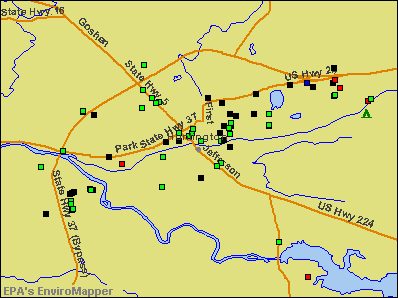
Notable locations in Huntington: Huntington Drive-In (A), Huntington City Fire Department (B), Huntington City Fire Department Station 1 (C), Huntington City Fire Department Station 2 (D), Huntington City Fire Department Station 3 (E). Display/hide their locations on the map
Churches in Huntington include: College Park Church (A), Mount Etna Church (B), Saint Felix Friary (C). Display/hide their locations on the map
Cemetery: Mount Hope Cemetery (1). Display/hide its location on the map
Reservoir: Huntington College Lake (A). Display/hide its location on the map
Streams, rivers, and creeks: Rabbit Run (A), Little River (B). Display/hide their locations on the map
Parks in Huntington include: Memorial Park (1), Hier Park (2), Laurie Park (3), Kriegbaum Field (4). Display/hide their locations on the map
Tourist attractions: Huntington CO Historical Society (Museums; 315 Court Street), Historic Forks of the Wabash Inc (Cultural Attractions- Events- & Facilities; 3011 West Park Drive), Huntington County Visitors Center (407 North Jefferson Street).
Hotels: Comfort Inn (2205 North Jefferson Street), Sheryl Manor Motel (1800 Etna Avenue), Amerihost Inn and Suites-Huntington (2820 Hotel Avenue), Comfort Inn Huntington (2205 North Jefferson Street), Day's Inn (2996 West Park Drive), Super 8 Motel (2801 Guilford Street).
Courts: Huntington County OFCS - Superior Court (Court House), Huntington County OFCS - Violations Clerk County Court (Court House), Huntington County OFCS - Circuit Court Room (Court House).
Birthplace of: Edwin Albert Link - Aviator, Elizebeth Friedman - Cryptanalyst and author, Chris Kramer - Basketball player, Denny Jiosa - Guitarist, Harry Mehre - Football player, Mark Warkentien - Basketball executive, Sean Kline - College basketball player (Indiana Hoosiers).
Drinking water stations with addresses in Huntington and their reported violations in the past:
HUNTINGTON WATER DEPARTMENT (Population served: 17,200, Groundwater):Past monitoring violations:CONVERSE WATER WORKS (Population served: 1,137, Groundwater):
- 21 regular monitoring violations
Past monitoring violations:PARKVIEW HUNTINGTON HOSPITAL (Population served: 25, Groundwater):
- Monitoring and Reporting (DBP) - Between JAN-2009 and DEC-2009, Contaminant: Total Haloacetic Acids (HAA5). Follow-up actions: St Public Notif requested (NOV-09-2009), St Violation/Reminder Notice (NOV-09-2009), St Compliance achieved (AUG-11-2010)
- Monitoring and Reporting (DBP) - Between JAN-2009 and DEC-2009, Contaminant: TTHM. Follow-up actions: St Public Notif requested (NOV-09-2009), St Violation/Reminder Notice (NOV-09-2009), St Compliance achieved (AUG-11-2010)
- One minor monitoring violation
Past health violations:
- MCL, Monthly (TCR) - In JUN-2009, Contaminant: Coliform. Follow-up actions: St Public Notif requested (JUL-08-2009), St Violation/Reminder Notice (JUL-08-2009), St Boil Water Order (JUL-08-2009), St Compliance achieved (MAR-24-2010)
Drinking water stations with addresses in Huntington that have no violations reported:
- ROUSH LAKE HUNTINGTON RES NORTH RAMP (Population served: 40, Primary Water Source Type: Groundwater)
- ROUSH LAKE HUNTINGTON RES CAMPGROUND (Population served: 25, Primary Water Source Type: Groundwater)
| This city: | 2.5 people |
| Indiana: | 2.5 people |
| This city: | 63.9% |
| Whole state: | 66.9% |
| This city: | 8.2% |
| Whole state: | 6.9% |
Likely homosexual households (counted as self-reported same-sex unmarried-partner households)
- Lesbian couples: 0.3% of all households
- Gay men: 0.2% of all households
People in group quarters in Huntington in 2010:
- 743 people in college/university student housing
- 133 people in nursing facilities/skilled-nursing facilities
- 122 people in local jails and other municipal confinement facilities
- 86 people in other noninstitutional facilities
- 47 people in group homes intended for adults
- 3 people in emergency and transitional shelters (with sleeping facilities) for people experiencing homelessness
People in group quarters in Huntington in 2000:
- 537 people in college dormitories (includes college quarters off campus)
- 168 people in nursing homes
- 89 people in local jails and other confinement facilities (including police lockups)
- 81 people in religious group quarters
- 26 people in homes for the mentally retarded
- 20 people in training schools for juvenile delinquents
- 16 people in other noninstitutional group quarters
- 10 people in hospitals or wards for drug/alcohol abuse
Banks with most branches in Huntington (2011 data):
- First Federal Savings Bank: Frontage Road Branch, at 648 N Jefferson St, 1240 S Jefferson St Branch. Info updated 2011/07/21: Bank assets: $261.6 mil, Deposits: $191.3 mil, local headquarters, positive income, Commercial Lending Specialization, 5 total offices
- The Bippus State Bank: South Jefferson Street Branch at 1303 South Jefferson Street, branch established on 1995/04/19; at 150 Hauenstein Road, branch established on 1911/06/23. Info updated 2006/11/03: Bank assets: $118.1 mil, Deposits: $95.0 mil, local headquarters, positive income, Agricultural Specialization, 4 total offices, Holding Company: Bippus State Corporation
- Wells Fargo Bank, National Association: Huntington North Branch at 2720 Guilford Street, branch established on 1987/10/17; Huntington Downtown Branch at 10 West Franklin Street, branch established on 1950/07/24. Info updated 2011/04/05: Bank assets: $1,161,490.0 mil, Deposits: $905,653.0 mil, headquarters in Sioux Falls, SD, positive income, 6395 total offices, Holding Company: Wells Fargo & Company
- 1st Source Bank: Huntington Branch at 1959 North Jefferson Street, branch established on 1890/01/01. Info updated 2008/06/16: Bank assets: $4,361.6 mil, Deposits: $3,520.6 mil, headquarters in South Bend, IN, positive income, Commercial Lending Specialization, 79 total offices, Holding Company: 1st Source Corporation
- MarkleBank: Huntington Branch at 2845 Guilford Street, branch established on 2001/01/29. Info updated 2006/11/03: Bank assets: $344.9 mil, Deposits: $275.7 mil, headquarters in Markle, IN, positive income, Agricultural Specialization, 7 total offices, Holding Company: Independent Alliance Banks, Inc.
- Lake City Bank: Huntington Branch at 1501 North Jefferson, branch established on 1986/12/23. Info updated 2006/05/11: Bank assets: $2,885.4 mil, Deposits: $2,413.2 mil, headquarters in Warsaw, IN, positive income, Commercial Lending Specialization, 45 total offices, Holding Company: Lakeland Financial Corporation
- PNC Bank, National Association: Huntington Northway at 2020 North Jefferson Street, branch established on 1969/07/21. Info updated 2012/03/20: Bank assets: $263,309.6 mil, Deposits: $197,343.0 mil, headquarters in Wilmington, DE, positive income, Commercial Lending Specialization, 3085 total offices, Holding Company: Pnc Financial Services Group, Inc., The
- Woodforest National Bank: Huntington Walmart Branch at 2800 Walmart Drive, branch established on 2008/04/05. Info updated 2011/05/10: Bank assets: $3,488.9 mil, Deposits: $3,097.6 mil, headquarters in Houston, TX, positive income, Commercial Lending Specialization, 766 total offices, Holding Company: Woodforest Financial Group Employee Stock Ownership Plan (With 401(K) Provisions)
- First Farmers Bank and Trust Company: Huntington Branch at 211 Hauenstein Road, branch established on 2007/07/01. Info updated 2009/12/09: Bank assets: $912.5 mil, Deposits: $732.0 mil, headquarters in Converse, IN, positive income, Agricultural Specialization, 20 total offices, Holding Company: First Farmers Financial Corporation
For population 15 years and over in Huntington:
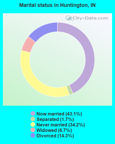
- Never married: 34.2%
- Now married: 43.1%
- Separated: 1.7%
- Widowed: 6.7%
- Divorced: 14.3%
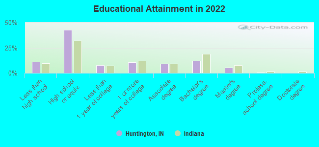
For population 25 years and over in Huntington:
- High school or higher: 88.8%
- Bachelor's degree or higher: 17.3%
- Graduate or professional degree: 6.1%
- Unemployed: 5.0%
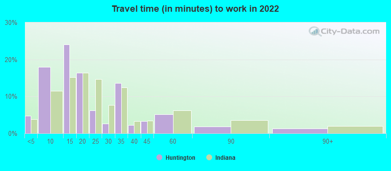
- Mean travel time to work (commute): 18.9 minutes
| Here: | 9.8 |
| Indiana average: | 11.3 |
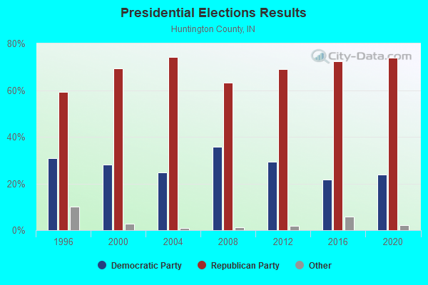
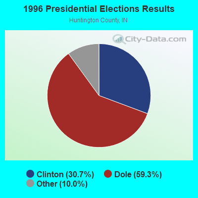

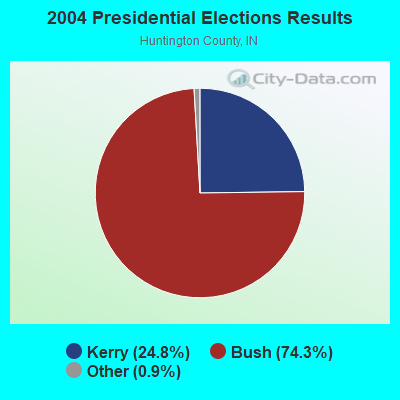
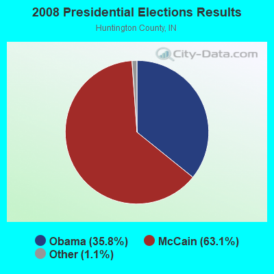
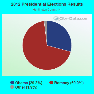
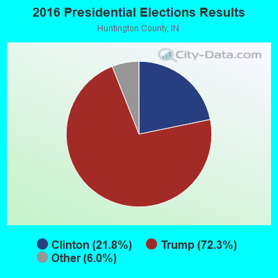
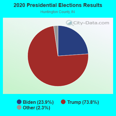
Graphs represent county-level data. Detailed 2008 Election Results
Religion statistics for Huntington, IN (based on Huntington County data)
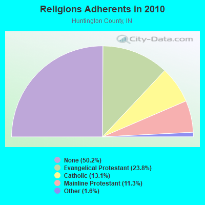
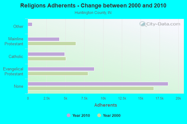
| Religion | Adherents | Congregations |
|---|---|---|
| Evangelical Protestant | 8,822 | 47 |
| Catholic | 4,876 | 3 |
| Mainline Protestant | 4,185 | 25 |
| Other | 600 | 3 |
| None | 18,641 | - |
Food Environment Statistics:
| Huntington County: | 1.33 / 10,000 pop. |
| State: | 1.73 / 10,000 pop. |
| Huntington County: | 5.30 / 10,000 pop. |
| State: | 3.57 / 10,000 pop. |
| This county: | 8.22 / 10,000 pop. |
| Indiana: | 6.78 / 10,000 pop. |
| Huntington County: | 9.6% |
| State: | 9.2% |
| Huntington County: | 30.4% |
| Indiana: | 29.0% |
| Huntington County: | 11.2% |
| State: | 14.3% |
Health and Nutrition:
| This city: | 49.0% |
| Indiana: | 49.3% |
| Huntington: | 45.1% |
| Indiana: | 46.2% |
| Here: | 29.0 |
| Indiana: | 28.7 |
| This city: | 21.5% |
| Indiana: | 21.3% |
| Here: | 12.9% |
| Indiana: | 10.6% |
| This city: | 6.8 |
| Indiana: | 6.8 |
| Huntington: | 33.8% |
| Indiana: | 33.9% |
| Huntington: | 55.9% |
| Indiana: | 56.1% |
| Huntington: | 77.6% |
| Indiana: | 78.7% |
More about Health and Nutrition of Huntington, IN Residents
| Local government employment and payroll (March 2022) | |||||
| Function | Full-time employees | Monthly full-time payroll | Average yearly full-time wage | Part-time employees | Monthly part-time payroll |
|---|---|---|---|---|---|
| Firefighters | 35 | $180,438 | $61,864 | 0 | $0 |
| Police Protection - Officers | 33 | $174,552 | $63,473 | 0 | $0 |
| Solid Waste Management | 14 | $53,375 | $45,750 | 0 | $0 |
| Water Supply | 13 | $55,607 | $51,330 | 0 | $0 |
| Other and Unallocable | 7 | $4,578 | $7,848 | 0 | $0 |
| Parks and Recreation | 6 | $23,702 | $47,404 | 0 | $0 |
| Streets and Highways | 4 | $20,872 | $62,616 | 0 | $0 |
| Housing and Community Development (Local) | 3 | $14,433 | $57,732 | 0 | $0 |
| Other Government Administration | 3 | $16,275 | $65,100 | 0 | $0 |
| Police - Other | 3 | $10,376 | $41,504 | 0 | $0 |
| Financial Administration | 3 | $14,185 | $56,740 | 1 | $472 |
| Judicial and Legal | 1 | $4,648 | $55,776 | 0 | $0 |
| Fire - Other | 1 | $3,793 | $45,516 | 0 | $0 |
| Totals for Government | 126 | $576,834 | $54,937 | 1 | $472 |
Huntington government finances - Expenditure in 2018 (per resident):
- Construction - Air Transportation: $693,000 ($40.71)
Housing and Community Development: $251,000 ($14.74)
Regular Highways: $170,000 ($9.99)
General - Other: $81,000 ($4.76)
General Public Buildings: $11,000 ($0.65)
- Current Operations - Police Protection: $2,933,000 ($172.30)
Local Fire Protection: $2,610,000 ($153.32)
Water Utilities: $2,380,000 ($139.81)
Regular Highways: $2,271,000 ($133.41)
Sewerage: $2,108,000 ($123.83)
Solid Waste Management: $892,000 ($52.40)
Parks and Recreation: $644,000 ($37.83)
General - Other: $340,000 ($19.97)
Air Transportation: $337,000 ($19.80)
Housing and Community Development: $251,000 ($14.74)
Central Staff Services: $131,000 ($7.70)
Financial Administration: $104,000 ($6.11)
General Public Buildings: $97,000 ($5.70)
Health - Other: $73,000 ($4.29)
Parking Facilities: $3,000 ($0.18)
Protective Inspection and Regulation - Other: $2,000 ($0.12)
- General - Interest on Debt: $2,140,000 ($125.71)
- Intergovernmental to Local - Other - Regular Highways: $560,000 ($32.90)
Other - Solid Waste Management: $32,000 ($1.88)
- Other Capital Outlay - Regular Highways: $488,000 ($28.67)
Solid Waste Management: $206,000 ($12.10)
Police Protection: $122,000 ($7.17)
Parks and Recreation: $58,000 ($3.41)
General Public Building: $32,000 ($1.88)
Parking Facilities: $12,000 ($0.70)
Local Fire Protection: $10,000 ($0.59)
General - Other: $3,000 ($0.18)
- Total Salaries and Wages: $5,985,000 ($351.58)
Huntington government finances - Revenue in 2018 (per resident):
- Charges - Sewerage: $10,977,000 ($644.83)
Air Transportation: $193,000 ($11.34)
Parks and Recreation: $43,000 ($2.53)
Parking Facilities: $20,000 ($1.17)
Other: $6,000 ($0.35)
Solid Waste Management: $6,000 ($0.35)
- Federal Intergovernmental - Air Transportation: $690,000 ($40.53)
- Local Intergovernmental - Highways: $103,000 ($6.05)
Other: $14,000 ($0.82)
- Miscellaneous - General Revenue - Other: $325,000 ($19.09)
Interest Earnings: $148,000 ($8.69)
Fines and Forfeits: $33,000 ($1.94)
Donations From Private Sources: $7,000 ($0.41)
Rents: $2,000 ($0.12)
- Revenue - Water Utilities: $6,389,000 ($375.32)
- State Intergovernmental - Other: $5,329,000 ($313.05)
Highways: $828,000 ($48.64)
General Local Government Support: $783,000 ($46.00)
Housing and Community Development: $251,000 ($14.74)
- Tax - Property: $9,372,000 ($550.55)
Public Utilities Sales: $87,000 ($5.11)
Other Selective Sales: $39,000 ($2.29)
Other License: $36,000 ($2.11)
Occupation and Business License - Other: $25,000 ($1.47)
Huntington government finances - Debt in 2018 (per resident):
- Long Term Debt - Outstanding Unspecified Public Purpose: $56,938,000 ($3344.77)
Beginning Outstanding - Unspecified Public Purpose: $53,517,000 ($3143.81)
Issue, Unspecified Public Purpose: $4,020,000 ($236.15)
Retired Unspecified Public Purpose: $599,000 ($35.19)
Huntington government finances - Cash and Securities in 2018 (per resident):
- Bond Funds - Cash and Securities: $4,313,000 ($253.36)
- Other Funds - Cash and Securities: $12,185,000 ($715.80)
- Sinking Funds - Cash and Securities: $6,778,000 ($398.17)
| Businesses in Huntington, IN | ||||
| Name | Count | Name | Count | |
|---|---|---|---|---|
| ALDI | 1 | La-Z-Boy | 1 | |
| AT&T | 1 | Lane Furniture | 2 | |
| Ace Hardware | 1 | Little Caesars Pizza | 1 | |
| Applebee's | 1 | MasterBrand Cabinets | 2 | |
| Arby's | 1 | Maurices | 1 | |
| AutoZone | 1 | McDonald's | 1 | |
| Burger King | 1 | Nike | 3 | |
| CVS | 1 | Papa John's Pizza | 1 | |
| Chevrolet | 1 | Penske | 1 | |
| Curves | 1 | Pizza Hut | 1 | |
| Dairy Queen | 2 | RadioShack | 1 | |
| Domino's Pizza | 1 | Sears | 1 | |
| FedEx | 3 | Subway | 3 | |
| Goodwill | 1 | Super 8 | 1 | |
| H&R Block | 1 | Taco Bell | 1 | |
| Holiday Inn | 1 | U-Haul | 1 | |
| JCPenney | 1 | UPS | 2 | |
| Jones New York | 1 | Vans | 1 | |
| KFC | 1 | Walmart | 1 | |
| Kmart | 1 | Wendy's | 1 | |
| Kroger | 2 | YMCA | 1 | |
Strongest AM radio stations in Huntington:
- WOWO (1190 AM; 50 kW; FORT WAYNE, IN; Owner: PATHFINDER COMMUNICATIONS CORPORATION)
- WBZQ (1300 AM; 0 kW; HUNTINGTON, IN; Owner: LARKO COMMUNICATIONS, INC.)
- WIBC (1070 AM; 50 kW; INDIANAPOLIS, IN; Owner: EMMIS RADIO LICENSE CORPORATION)
- WONO (1380 AM; 5 kW; FORT WAYNE, IN; Owner: PATHFINDER COMMUNICATIONS CORPORATION)
- WGL (1250 AM; 2 kW; FORT WAYNE, IN; Owner: TRAVIS BROADCASTING, LLC)
- WLW (700 AM; 50 kW; CINCINNATI, OH; Owner: JACOR BROADCASTING CORPORATION)
- WFCV (1090 AM; daytime; 2 kW; FORT WAYNE, IN; Owner: BOTT BROADCASTING COMPANY)
- WLS (890 AM; 50 kW; CHICAGO, IL; Owner: WLS, INC.)
- WSCR (670 AM; 50 kW; CHICAGO, IL; Owner: INFINITY BROADCASTING OPERATIONS, INC.)
- WFDF (910 AM; 50 kW; FLINT, MI; Owner: ABC, INC.)
- WJR (760 AM; 50 kW; DETROIT, MI; Owner: ABC, INC.)
- WGN (720 AM; 50 kW; CHICAGO, IL; Owner: WGN CONTINENTAL BROADCASTING CO.)
- WTVN (610 AM; 50 kW; COLUMBUS, OH; Owner: CITICASTERS LICENSES, L.P.)
Strongest FM radio stations in Huntington:
- WCKZ (94.1 FM; ROANOKE, IN; Owner: TRAVIS BROADCASTING, LLC)
- WVSH (91.9 FM; HUNTINGTON, IN; Owner: HUNTINGTON COUNTY COMM. SCH. CORP.)
- WXKE (102.9 FM; HUNTINGTON, IN; Owner: TAVIS BROADCASTING, LLC)
- WLAB (88.3 FM; FORT WAYNE, IN; Owner: INDIANA DISTTRICT OF THE LUTHERAN CHURCH - MO SYNOD, INC.)
- WBCL (90.3 FM; FORT WAYNE, IN; Owner: TAYLOR UNIVERSITY BROADCASTING, INC.)
- WMEE (97.3 FM; FORT WAYNE, IN; Owner: PATHFINDER COMMUNICATIONS CORPORATION)
- WAJI (95.1 FM; FORT WAYNE, IN; Owner: SARKES TARZIAN, INC.)
- WKUZ (95.9 FM; WABASH, IN; Owner: UPPER WABASH BROADCASTING CORP.)
- WBNI-FM (89.1 FM; FORT WAYNE, IN; Owner: PUBLIC BROADCASTING OF NE IN., INC.)
- WSHI (106.3 FM; COLUMBIA CITY, IN; Owner: JAMMIN' BROADCASTING, LLC)
- WNHT (96.3 FM; CHURUBUSCO, IN; Owner: TRAVIS BROADCASTING, LLC)
- WFWI (92.3 FM; FORT WAYNE, IN; Owner: PATHFINDER COMMUNICATIONS CORPORATION)
- WMRI (106.9 FM; MARION, IN; Owner: MID-AMERICA RADIO OF INDIANA, INC.)
- WCJC (99.3 FM; VAN BUREN, IN; Owner: MID-AMERICA RADIO GROUP, INC.)
- WBSW (90.9 FM; MARION, IN; Owner: BALL STATE UNIVERSITY)
- WCYT (91.1 FM; LAFAYETTE TOWNSHIP, IN; Owner: SOUTHWEST ALLEN COUNTY SCHOOLS)
- WNUY (100.1 FM; BLUFFTON, IN; Owner: WELLS COUNTY RADIO CORP.)
- WJOT-FM (105.9 FM; WABASH, IN; Owner: MID-AMERICA RADIO OF WABASH, INC.)
- WLZQ (101.1 FM; SOUTH WHITLEY, IN; Owner: LARKO COMMUNICATIONS INC)
- WARU-FM (101.9 FM; ROANN, IN; Owner: MID-AMERICA RADIO GROUP, INC.)
TV broadcast stations around Huntington:
- WANE-TV (Channel 15; FORT WAYNE, IN; Owner: INDIANA BROADCASTING, LLC)
- WSOT-LP (Channel 57; MARION, IN; Owner: SUNNYCREST MEDIA, INC.)
- WFFT-TV (Channel 55; FORT WAYNE, IN; Owner: QUOROM OF FT. WAYNE LICENSE, LLC)
- WPTA (Channel 21; FORT WAYNE, IN; Owner: WPTA-TV LICENSE, INC.)
- WISE-TV (Channel 33; FORT WAYNE, IN; Owner: NVG-FORT WAYNE II, LLC)
- WFWA (Channel 39; FORT WAYNE, IN; Owner: FORT WAYNE PUBLIC TELEVISION, INC.)
- W66BD (Channel 53; FORT WAYNE, IN; Owner: TRI-STATE CHRISTIAN TELEVISION)
- WIWU-LP (Channel 51; MARION, IN; Owner: IWU COMMUNICATIONS, INC.)
- W45AG (Channel 45; FORT WAYNE, IN; Owner: TRAN STAR, INC.)
- DW68BN (Channel 68; FORT WAYNE, IN; Owner: ZONATION BROADCASTING)
- National Bridge Inventory (NBI) Statistics
- 51Number of bridges
- 515ft / 157mTotal length
- $1,853,000Total costs
- 142,554Total average daily traffic
- 15,806Total average daily truck traffic
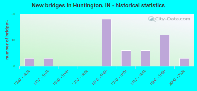
- New bridges - historical statistics
- 31920-1929
- 31930-1939
- 181960-1969
- 61970-1979
- 61980-1989
- 121990-1999
- 32000-2009
FCC Registered Antenna Towers: 144 (See the full list of FCC Registered Antenna Towers)
FCC Registered Commercial Land Mobile Towers: 1 (See the full list of FCC Registered Commercial Land Mobile Towers in Huntington, IN)
FCC Registered Private Land Mobile Towers: 5 (See the full list of FCC Registered Private Land Mobile Towers)
FCC Registered Broadcast Land Mobile Towers: 54 (See the full list of FCC Registered Broadcast Land Mobile Towers)
FCC Registered Microwave Towers: 47 (See the full list of FCC Registered Microwave Towers in this town)
FCC Registered Paging Towers: 4 (See the full list of FCC Registered Paging Towers)
FCC Registered Maritime Coast & Aviation Ground Towers: 3 (See the full list of FCC Registered Maritime Coast & Aviation Ground Towers)
FCC Registered Amateur Radio Licenses: 198 (See the full list of FCC Registered Amateur Radio Licenses in Huntington)
FAA Registered Aircraft: 34 (See the full list of FAA Registered Aircraft in Huntington)
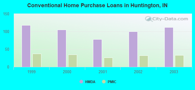
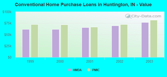
| Home Mortgage Disclosure Act Aggregated Statistics For Year 2003 (Based on 1 full and 4 partial tracts) | ||||||||||||
| A) FHA, FSA/RHS & VA Home Purchase Loans | B) Conventional Home Purchase Loans | C) Refinancings | D) Home Improvement Loans | E) Loans on Dwellings For 5+ Families | F) Non-occupant Loans on < 5 Family Dwellings (A B C & D) | |||||||
|---|---|---|---|---|---|---|---|---|---|---|---|---|
| Number | Average Value | Number | Average Value | Number | Average Value | Number | Average Value | Number | Average Value | Number | Average Value | |
| LOANS ORIGINATED | 22 | $80,157 | 112 | $76,787 | 397 | $76,663 | 19 | $20,171 | 2 | $171,505 | 53 | $51,122 |
| APPLICATIONS APPROVED, NOT ACCEPTED | 0 | $0 | 10 | $59,528 | 35 | $74,870 | 2 | $8,760 | 0 | $0 | 3 | $72,783 |
| APPLICATIONS DENIED | 5 | $86,636 | 26 | $62,873 | 118 | $70,646 | 19 | $18,169 | 0 | $0 | 11 | $57,996 |
| APPLICATIONS WITHDRAWN | 0 | $0 | 10 | $81,404 | 61 | $69,511 | 1 | $30,080 | 0 | $0 | 4 | $52,990 |
| FILES CLOSED FOR INCOMPLETENESS | 0 | $0 | 3 | $53,510 | 17 | $86,448 | 1 | $44,600 | 0 | $0 | 0 | $0 |
Detailed HMDA statistics for the following Tracts: 9914.00 , 9915.00, 9916.00, 9918.00, 9919.00
| Private Mortgage Insurance Companies Aggregated Statistics For Year 2003 (Based on 1 full and 4 partial tracts) | ||||||
| A) Conventional Home Purchase Loans | B) Refinancings | C) Non-occupant Loans on < 5 Family Dwellings (A & B) | ||||
|---|---|---|---|---|---|---|
| Number | Average Value | Number | Average Value | Number | Average Value | |
| LOANS ORIGINATED | 33 | $82,044 | 53 | $81,398 | 3 | $65,560 |
| APPLICATIONS APPROVED, NOT ACCEPTED | 6 | $77,117 | 14 | $82,916 | 0 | $0 |
| APPLICATIONS DENIED | 1 | $85,280 | 1 | $116,430 | 1 | $77,050 |
| APPLICATIONS WITHDRAWN | 4 | $86,040 | 1 | $55,840 | 0 | $0 |
| FILES CLOSED FOR INCOMPLETENESS | 0 | $0 | 1 | $116,940 | 0 | $0 |
Detailed PMIC statistics for the following Tracts: 9914.00 , 9915.00, 9916.00, 9918.00, 9919.00
2002 - 2018 National Fire Incident Reporting System (NFIRS) incidents
- Fire incident types reported to NFIRS in Huntington, IN
- 64540.8%Structure Fires
- 64440.8%Outside Fires
- 23815.1%Mobile Property/Vehicle Fires
- 533.4%Other
 Based on the data from the years 2002 - 2018 the average number of fire incidents per year is 93. The highest number of fire incidents - 138 took place in 2006, and the least - 14 in 2018. The data has a dropping trend.
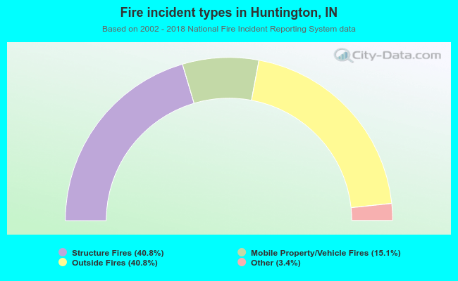 When looking into fire subcategories, the most incidents belonged to: Structure Fires (40.8%), and Outside Fires (40.8%).
| Most common first names in Huntington, IN among deceased individuals | ||
| Name | Count | Lived (average) |
|---|---|---|
| Mary | 212 | 80.3 years |
| John | 165 | 76.0 years |
| Robert | 146 | 74.6 years |
| Charles | 134 | 76.5 years |
| William | 132 | 75.3 years |
| Paul | 105 | 75.4 years |
| Helen | 105 | 79.6 years |
| James | 103 | 72.7 years |
| Ruth | 82 | 80.5 years |
| George | 77 | 76.6 years |
| Most common last names in Huntington, IN among deceased individuals | ||
| Last name | Count | Lived (average) |
|---|---|---|
| Smith | 115 | 77.4 years |
| Miller | 110 | 77.4 years |
| Johnson | 50 | 78.1 years |
| Brown | 42 | 76.9 years |
| Young | 35 | 78.5 years |
| Baker | 34 | 79.0 years |
| Eckert | 31 | 75.1 years |
| Myers | 30 | 78.9 years |
| Jones | 30 | 75.1 years |
| Kline | 29 | 80.8 years |
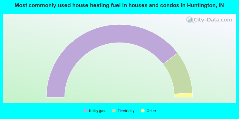
- 79.2%Utility gas
- 18.9%Electricity
- 1.0%Bottled, tank, or LP gas
- 0.9%Other fuel
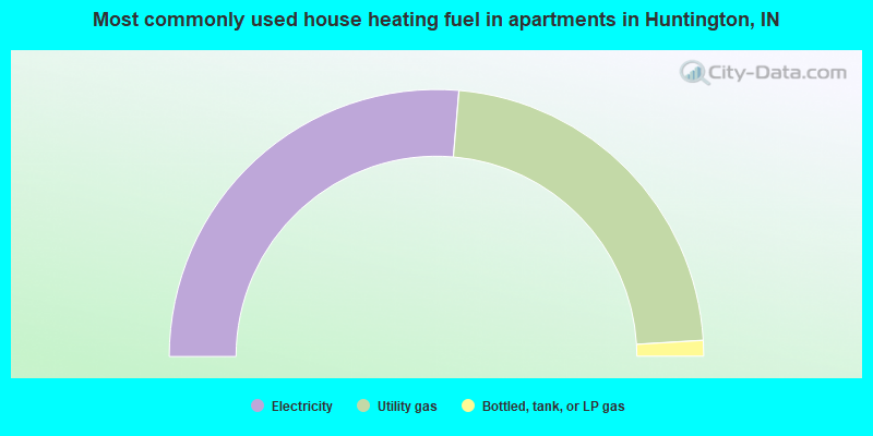
- 52.7%Electricity
- 45.4%Utility gas
- 1.9%Bottled, tank, or LP gas
Huntington compared to Indiana state average:
- Median house value below state average.
- Unemployed percentage below state average.
- Black race population percentage significantly below state average.
- Hispanic race population percentage below state average.
- Median age below state average.
- Foreign-born population percentage significantly below state average.
- Length of stay since moving in above state average.
- House age above state average.
Huntington on our top lists:
- #95 on the list of "Top 101 cities with largest percentage of males in industries: manufacturing (population 5,000+)"

|
|
Total of 75 patent applications in 2008-2024.