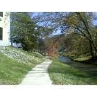
Inez, Kentucky
Submit your own pictures of this city and show them to the world
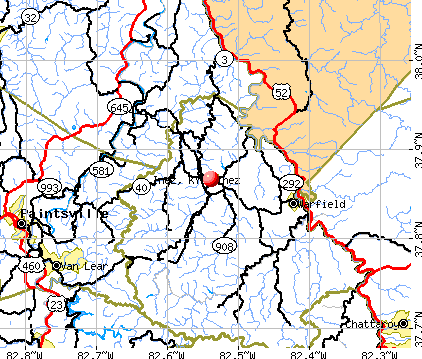
- OSM Map
- General Map
- Google Map
- MSN Map
Population change since 2000: +12.2%
| Males: 229 | |
| Females: 294 |
| Median resident age: | 51.9 years |
| Kentucky median age: | 39.4 years |
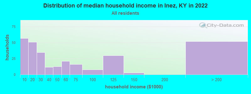
| Inez: | $36,639 |
| KY: | $59,341 |
Estimated per capita income in 2022: $34,551 (it was $14,183 in 2000)
Inez city income, earnings, and wages data
Estimated median house or condo value in 2022: $-739,359,698 (it was $58,800 in 2000)
| Inez: | |
| KY: |
Mean prices in 2022: all housing units: $134,598; detached houses: $152,541; mobile homes: $90,301
Median gross rent in 2022: $493.
(23.8% for White Non-Hispanic residents, 42.9% for two or more races residents)
Detailed information about poverty and poor residents in Inez, KY
Compare current foreclosures near Inez, KY:
| Photo | Address | Area | Beds / Baths | Price | Details |
|---|---|---|---|---|---|

|
#1
Tug River Rd
Inez, KY 41224
|
1,134 sq. feet
|
1 baths 2 beds |
show details | |

|
#2
Spruce Pine Rd
Inez, KY 41224
|
- sq. feet
|
- baths - beds |
show details | |

|
#3
Big Elk Rd
Inez, KY 41224
|
1,104 sq. feet
|
- baths - beds |
show details | |

|
#4
Morgan Kirk Loop
Inez, KY 41224
|
- sq. feet
|
- baths - beds |
show details | |

|
#5
Garland Spence Dr
Inez, KY 41224
|
- sq. feet
|
- baths - beds |
show details | |

|
#6
Tug River Rd
Inez, KY 41224
|
720 sq. feet
|
- baths - beds |
show details | |

|
#7
Wickerfield Rd
Inez, KY 41224
|
- sq. feet
|
- baths - beds |
show details | |

|
#8
Olivene Dr
Inez, KY 41224
|
- sq. feet
|
- baths - beds |
show details | |

|
#9
Sycamore Ests
Inez, KY 41224
|
- sq. feet
|
- baths - beds |
show details | |

|
#10
Mountain Enterprise Dr
Inez, KY 41224
|
- sq. feet
|
- baths - beds |
show details |
| Photo | Address | Area | Beds / Baths | Price | Details |
|---|---|---|---|---|---|

|
#11
Newberry Ln
Inez, KY 41224
|
- sq. feet
|
- baths - beds |
show details | |

|
#12
Dans Branch Rd
Williamson, WV 25661
|
1,040 sq. feet
|
1 baths 3 beds |
show details | |

|
#13
Ky Route 3224
River, KY 41254
|
1,420 sq. feet
|
2 baths 3 beds |
show details | |

|
#14
Kentucky Rte 3224
River, KY 41254
|
- sq. feet
|
- baths - beds |
$23,900
|
show details |

|
#15
Route 993
Paintsville, KY 41240
|
1,584 sq. feet
|
2 baths 3 beds |
show details | |

|
#16
Wv 65
Williamson, WV 25661
|
1,569 sq. feet
|
1 baths 3 beds |
show details | |

|
#17
Old River Rd
Louisa, KY 41230
|
912 sq. feet
|
1 baths 2 beds |
show details | |

|
#18
Red Garden Ln
Louisa, KY 41230
|
1,600 sq. feet
|
1 baths 3 beds |
show details | |

|
#19
Church Dr
Paintsville, KY 41240
|
2,352 sq. feet
|
2 baths 4 beds |
show details | |

|
#20
Dicey Frk
Meally, KY 41234
|
1,545 sq. feet
|
2 baths 3 beds |
show details |
| Photo | Address | Area | Beds / Baths | Price | Details |
|---|---|---|---|---|---|

|
#21
Auxier Ave
Paintsville, KY 41240
|
1,722 sq. feet
|
1 baths 4 beds |
show details | |

|
#22
Ky Route 993
Paintsville, KY 41240
|
1,536 sq. feet
|
1 baths 3 beds |
show details | |

|
#23
Lyons Dr
Paintsville, KY 41240
|
2,296 sq. feet
|
2 baths 3 beds |
show details | |

|
#24
Buffalo Rd
Meally, KY 41234
|
1,672 sq. feet
|
2 baths 3 beds |
show details | |

|
#25
Ky Route 201
Sitka, KY 41255
|
1,932 sq. feet
|
3 baths 5 beds |
show details | |

|
#26
Clyde Davis Dr
Tomahawk, KY 41262
|
1,232 sq. feet
|
1 baths 3 beds |
show details | |

|
#27
Crisp Fitzpatrick Pl
Tomahawk, KY 41262
|
1,344 sq. feet
|
1 baths 3 beds |
show details | |

|
#28
N Mays Ave
Prestonsburg, KY 41653
|
988 sq. feet
|
1 baths 2 beds |
show details | |

|
#29
Rose St
Louisa, KY 41230
|
1,537 sq. feet
|
2 baths 3 beds |
show details | |

|
#30
Murray Dr
Sitka, KY 41255
|
864 sq. feet
|
1 baths 3 beds |
show details |
| Photo | Address | Area | Beds / Baths | Price | Details |
|---|---|---|---|---|---|

|
#31
Sunset Acres Dr
Louisa, KY 41230
|
1,643 sq. feet
|
2 baths 4 beds |
show details | |

|
#32
Ky Route 1596
Boons Camp, KY 41204
|
2,510 sq. feet
|
2 baths 3 beds |
show details | |

|
#33
Webb Holw
Van Lear, KY 41265
|
960 sq. feet
|
- baths - beds |
show details | |

|
#34
Jacobs Ln
Warfield, KY 41267
|
1,965 sq. feet
|
1 baths - beds |
show details | |

|
#35
Auxier Ave
Auxier, KY 41602
|
- sq. feet
|
- baths - beds |
show details | |

|
#36
Lakeview Village Ln
Prestonsburg, KY 41653
|
- sq. feet
|
- baths - beds |
show details | |

|
#37
Cherry Hill Ln
Hagerhill, KY 41222
|
- sq. feet
|
- baths - beds |
show details | |

|
#38
Sunny Ln
Hagerhill, KY 41222
|
- sq. feet
|
- baths - beds |
show details | |

|
#39
Industrial Park Lot 1
Hagerhill, KY 41222
|
- sq. feet
|
- baths - beds |
show details | |

|
#40
Main St Apt 5
Paintsville, KY 41240
|
- sq. feet
|
- baths - beds |
show details |
| Photo | Address | Area | Beds / Baths | Price | Details |
|---|---|---|---|---|---|

|
#41
Right Fork Of Brushy Rd
Varney, KY 41571
|
- sq. feet
|
- baths - beds |
show details | |

|
#42
1st St Apt 30
Prestonsburg, KY 41653
|
- sq. feet
|
- baths - beds |
show details | |

|
#43
Bear Holw
East Point, KY 41216
|
- sq. feet
|
- baths - beds |
show details | |

|
#44
South Route 321
Hagerhill, KY 41222
|
- sq. feet
|
- baths - beds |
show details | |

|
#45
Madison Ave
Prestonsburg, KY 41653
|
- sq. feet
|
- baths - beds |
show details | |

|
#46
Storm Holw
East Point, KY 41216
|
- sq. feet
|
- baths - beds |
show details | |

|
#47
Delong Rd
Hagerhill, KY 41222
|
2,048 sq. feet
|
- baths - beds |
show details | |

|
#48
Main St Apt 112
Paintsville, KY 41240
|
- sq. feet
|
- baths - beds |
show details | |

|
#49
Ferguson Branch Rd
Dunlow, WV 25511
|
- sq. feet
|
- baths - beds |
show details | |

|
Check over 1 million property listings on Foreclosure.com!
|
browse all offers | |||


- 80596.3%White alone
- 293.5%Two or more races
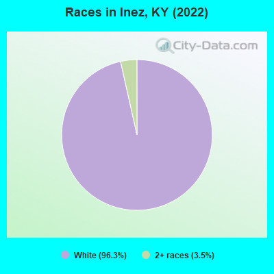
Races in Inez detailed stats: ancestries, foreign born residents, place of birth
According to our research of Kentucky and other state lists, there were 9 registered sex offenders living in Inez, Kentucky as of May 11, 2024.
The ratio of all residents to sex offenders in Inez is 89 to 1.
 Recent articles from our blog. Our writers, many of them Ph.D. graduates or candidates, create easy-to-read articles on a wide variety of topics.

 | Is eastern Kentucky really that bad off? (107 replies) |
| What do you like Least? (112 replies) |
| Diane Sawyer report on Appalachian Poverty (231 replies) |
| Does rural Kentucky hate Louisville? (174 replies) |
| What is/are the friendliest region(s) of Kentucky, in your opinion? (21 replies) |
| Northern Kentucky/Greater Cincinnati Housing Report (3 replies) |
Latest news from Inez, KY collected exclusively by city-data.com from local newspapers, TV, and radio stations
Ancestries: American (62.4%), English (23.8%), Irish (6.4%), British (2.5%), Scotch-Irish (2.2%).
Current Local Time: EST time zone
Incorporated on 02/05/1942
Elevation: 636 feet
Land area: 0.66 square miles.
Population density: 797 people per square mile (low).

| Inez city: | 0.6% ($326) |
| Kentucky: | 0.8% ($610) |
Nearest city with pop. 50,000+: Huntington, WV  (38.2 miles , pop. 51,475).
Nearest city with pop. 200,000+: Fayette, KY (107.3 miles , pop. 260,512).
Nearest city with pop. 1,000,000+: Chicago, IL (387.2 miles , pop. 2,896,016).
Nearest cities:
), ), ), ), ), )Latitude: 37.87 N, Longitude: 82.54 W
Area code: 606

| Here: | 8.2% |
| Kentucky: | 3.8% |
- Health care (15.7%)
- Mining, quarrying, oil & gas extraction (13.4%)
- Educational services (10.4%)
- Administrative & support & waste management services (5.2%)
- Truck transportation (4.5%)
- Finance & insurance (4.5%)
- Real estate & rental & leasing (4.5%)
- Mining, quarrying, oil & gas extraction (25.4%)
- Educational services (11.1%)
- Truck transportation (9.5%)
- Public administration (7.9%)
- Administrative & support & waste management services (7.9%)
- Construction (6.3%)
- Other transportation, support activities, couriers (4.8%)
- Health care (29.6%)
- Educational services (9.9%)
- Real estate & rental & leasing (8.5%)
- Food & beverage stores (7.0%)
- Social assistance (5.6%)
- Gasoline stations (4.2%)
- Finance & insurance (4.2%)
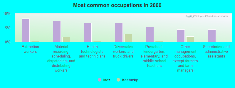
- Extraction workers (8.2%)
- Material recording, scheduling, dispatching, and distributing workers (7.5%)
- Health technologists and technicians (6.7%)
- Driver/sales workers and truck drivers (6.7%)
- Preschool, kindergarten, elementary, and middle school teachers (5.2%)
- Other management occupations, except farmers and farm managers (4.5%)
- Secretaries and administrative assistants (4.5%)
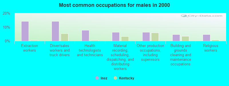
- Extraction workers (14.3%)
- Driver/sales workers and truck drivers (14.3%)
- Health technologists and technicians (7.9%)
- Material recording, scheduling, dispatching, and distributing workers (6.3%)
- Other production occupations, including supervisors (6.3%)
- Building and grounds cleaning and maintenance occupations (4.8%)
- Religious workers (4.8%)

- Other management occupations, except farmers and farm managers (8.5%)
- Material recording, scheduling, dispatching, and distributing workers (8.5%)
- Secretaries and administrative assistants (8.5%)
- Preschool, kindergarten, elementary, and middle school teachers (7.0%)
- Information and record clerks, except customer service representatives (5.6%)
- Health technologists and technicians (5.6%)
- Nursing, psychiatric, and home health aides (5.6%)
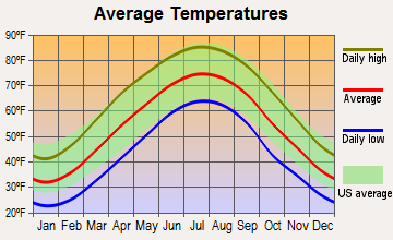
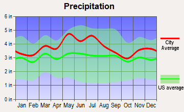
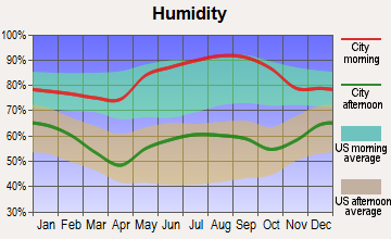
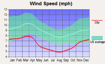
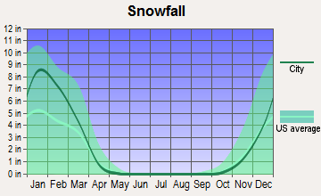
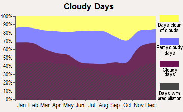
Average climate in Inez, Kentucky
Based on data reported by over 4,000 weather stations

Tornado activity:
Inez-area historical tornado activity is significantly below Kentucky state average. It is 71% smaller than the overall U.S. average.
On 4/23/1968, a category F5 (max. wind speeds 261-318 mph) tornado 59.4 miles away from the Inez city center killed 7 people and injured 93 people and caused between $500,000 and $5,000,000 in damages.
On 4/8/1965, a category F3 (max. wind speeds 158-206 mph) tornado 32.1 miles away from the city center injured 3 people and caused between $50,000 and $500,000 in damages.
Earthquake activity:
Inez-area historical earthquake activity is significantly above Kentucky state average. It is 18% greater than the overall U.S. average.On 7/27/1980 at 18:52:21, a magnitude 5.2 (5.1 MB, 4.7 MS, 5.0 UK, 5.2 UK, Class: Moderate, Intensity: VI - VII) earthquake occurred 80.0 miles away from Inez center
On 8/23/2011 at 17:51:04, a magnitude 5.8 (5.8 MW, Depth: 3.7 mi) earthquake occurred 251.2 miles away from the city center
On 8/9/2020 at 12:07:37, a magnitude 5.1 (5.1 MW, Depth: 4.7 mi) earthquake occurred 124.9 miles away from Inez center
On 9/7/1988 at 02:28:09, a magnitude 4.6 (4.5 MB, 4.6 LG, Class: Light, Intensity: IV - V) earthquake occurred 75.4 miles away from Inez center
On 11/2/2006 at 17:53:02, a magnitude 4.3 (4.3 MB, Depth: 0.6 mi) earthquake occurred 57.3 miles away from the city center
On 11/23/2006 at 10:42:57, a magnitude 4.3 (4.3 MB) earthquake occurred 58.0 miles away from the city center
Magnitude types: regional Lg-wave magnitude (LG), body-wave magnitude (MB), surface-wave magnitude (MS), moment magnitude (MW)
Natural disasters:
The number of natural disasters in Martin County (27) is a lot greater than the US average (15).Major Disasters (Presidential) Declared: 18
Emergencies Declared: 3
Causes of natural disasters: Floods: 17, Storms: 14, Tornadoes: 6, Mudslides: 5, Winter Storms: 5, Fires: 3, Landslides: 3, Winds: 3, Snows: 2, Blizzard: 1, Freeze: 1, Hurricane: 1, Snowfall: 1, Snowstorm: 1, Other: 1 (Note: some incidents may be assigned to more than one category).

Hospitals and medical centers in Inez:
Heliports located in Inez:
Colleges/universities with over 2000 students nearest to Inez:
- Big Sandy Community and Technical College (about 19 miles; Prestonsburg, KY; Full-time enrollment: 2,660)
- Marshall University (about 39 miles; Huntington, WV; FT enrollment: 11,450)
- Ashland Community and Technical College (about 43 miles; Ashland, KY; FT enrollment: 2,482)
- Morehead State University (about 54 miles; Morehead, KY; FT enrollment: 7,523)
- West Virginia State University (about 55 miles; Institute, WV; FT enrollment: 2,133)
- Hazard Community and Technical College (about 56 miles; Hazard, KY; FT enrollment: 2,087)
- Shawnee State University (about 65 miles; Portsmouth, OH; FT enrollment: 4,160)
Public high school in Inez:
- SHELDON CLARK HIGH SCHOOL (Students: 668, Location: 388 CARDINAL LANE, Grades: 9-12)
Public elementary/middle schools in Inez:
- EDEN ELEMENTARY SCHOOL (Students: 360, Location: 179 EDEN LANE, Grades: PK-5)
- INEZ ELEMENTARY SCHOOL (Students: 328, Location: 5000 ELEMENTARY DR, Grades: PK-5)
Points of interest:
Notable location: Inez Volunteer Fire Department (A). Display/hide its location on the map
Streams, rivers, and creeks: Coldwater Fork (A), Middle Fork Rockcastle Creek (B), Kingfisher Branch (C), Lick Branch (D). Display/hide their locations on the map
Tourist attraction: Starlite Arcade (Amusement & Theme Parks; 98 Coldwater Road).
Hotels: Super 8 Inez KY (Route 40 Blacklog Road), Cain Hotel (Ulysses Road), Impala Motel (Blacklog Road), Inez Motel & Restaurant (Main Street).
Court: Martin County - Circuit Court Clerk OFC (Courthouse Street).
Drinking water stations with addresses in Inez and their reported violations in the past:
MARTIN CO WATER DISTRICT #1 (Population served: 10,395, Surface water):Past health violations:Past monitoring violations:
- MCL, Average - Between APR-2013 and JUN-2013, Contaminant: Total Haloacetic Acids (HAA5). Follow-up actions: St Public Notif requested (JUL-31-2013), St Formal NOV issued (JUL-31-2013), St Public Notif received (SEP-04-2013), St Compliance achieved (NOV-13-2013)
- MCL, Average - Between JAN-2013 and MAR-2013, Contaminant: Total Haloacetic Acids (HAA5). Follow-up actions: St Public Notif requested (MAY-02-2013), St Formal NOV issued (MAY-02-2013), St Public Notif received (MAY-31-2013), St Compliance achieved (NOV-13-2013)
- MCL, Average - Between JAN-2013 and MAR-2013, Contaminant: TTHM. Follow-up actions: St Public Notif requested (MAY-02-2013), St Formal NOV issued (MAY-02-2013), St Public Notif received (MAY-31-2013), St Compliance achieved (NOV-13-2013)
- MCL, Average - Between JUL-2011 and SEP-2011, Contaminant: Total Haloacetic Acids (HAA5). Follow-up actions: St Public Notif requested (NOV-03-2011), St Formal NOV issued (NOV-03-2011), St Public Notif received (DEC-07-2011), St Compliance achieved (FEB-13-2012)
- MCL, Average - Between APR-2011 and JUN-2011, Contaminant: Total Haloacetic Acids (HAA5). Follow-up actions: St Public Notif requested (AUG-09-2011), St Formal NOV issued (AUG-09-2011), St Public Notif received (SEP-15-2011), St Compliance achieved (FEB-13-2012), St AO (w/penalty) issued (MAR-05-2012)
- MCL, Average - Between APR-2011 and JUN-2011, Contaminant: TTHM. Follow-up actions: St Public Notif requested (AUG-09-2011), St Formal NOV issued (AUG-09-2011), St Public Notif received (SEP-15-2011), St Compliance achieved (FEB-13-2012), St AO (w/penalty) issued (MAR-05-2012)
- 6 other older health violations
- Monthly Turbidity Exceed (Enhanced SWTR) - In JAN-2014, Contaminant: IESWTR. Follow-up actions: St Public Notif requested (MAR-10-2014), St Formal NOV issued (MAR-10-2014), St Public Notif received (APR-03-2014), St Compliance achieved (APR-15-2014)
- Monitoring, Turbidity (Enhanced SWTR) - In FEB-2013, Contaminant: IESWTR. Follow-up actions: St Public Notif requested (APR-11-2013), St Formal NOV issued (APR-11-2013), St Compliance achieved (JUN-13-2013), St Public Notif received (JUL-02-2013)
- Monitoring of Treatment (SWTR-Filter) - In FEB-2013. Follow-up actions: St Public Notif requested (APR-11-2013), St Formal NOV issued (APR-11-2013), St Compliance achieved (JUN-13-2013), St Public Notif received (JUL-02-2013)
- Monitoring of Treatment (SWTR-Filter) - In JUL-2012. Follow-up actions: St Public Notif requested (SEP-28-2012), St Formal NOV issued (SEP-28-2012), St Compliance achieved (OCT-24-2012), St Public Notif received (MAY-31-2013)
- Treatment Technique Precursor Removal - Between JAN-2006 and MAR-2006, Contaminant: CARBON, TOTAL. Follow-up actions: St Public Notif requested (MAY-31-2006), St Formal NOV issued (MAY-31-2006), St Compliance achieved (JUL-10-2006), St Public Notif received (DEC-07-2006)
- 2 regular monitoring violations
- 2 other older monitoring violations
| This city: | 2.1 people |
| Kentucky: | 2.5 people |
| This city: | 56.1% |
| Whole state: | 66.9% |
| This city: | 1.6% |
| Whole state: | 6.4% |
No gay or lesbian households reported
4 people in other workers' dormitories in 2000
Banks with branches in Inez (2011 data):
- The First Commonwealth Bank of Prestonsburg, Inc.: Inez Branch at 87 Main Street, branch established on 1936/06/01. Info updated 2011/05/20: Bank assets: $310.9 mil, Deposits: $226.6 mil, headquarters in Prestonsburg, KY, positive income, 13 total offices, Holding Company: First Prestonsburg Bancshares, Inc.
- Inez Deposit Bank: at 41 Main Street, branch established on 1904/05/01. Info updated 2011/08/24: Bank assets: $166.2 mil, Deposits: $146.1 mil, local headquarters, positive income, 4 total offices, Holding Company: Community Holding Company
For population 15 years and over in Inez:
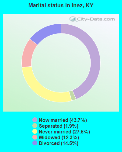
- Never married: 27.5%
- Now married: 43.7%
- Separated: 1.9%
- Widowed: 12.3%
- Divorced: 14.5%
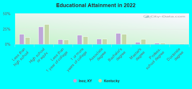
For population 25 years and over in Inez:
- High school or higher: 81.2%
- Bachelor's degree or higher: 22.1%
- Graduate or professional degree: 5.5%
- Unemployed: 10.1%
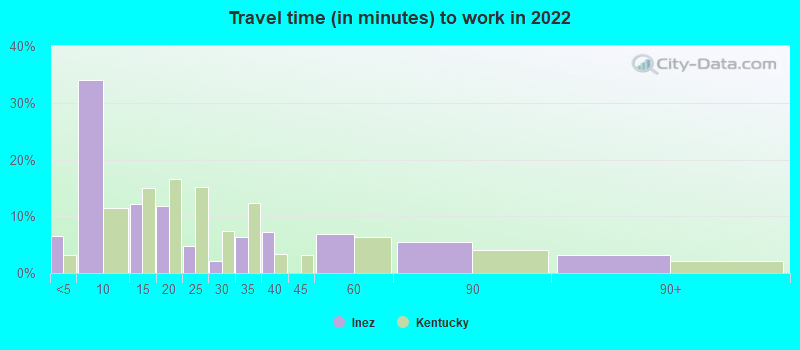
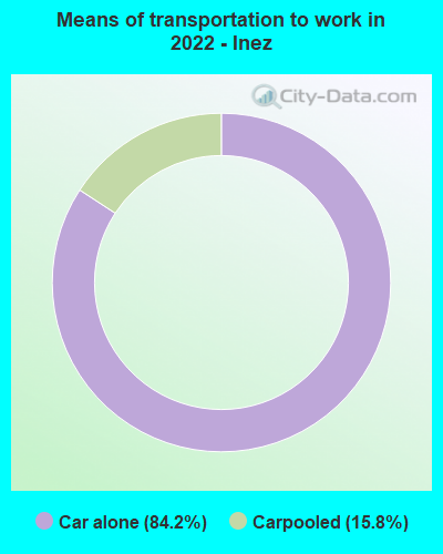
- Mean travel time to work (commute): 16.9 minutes

| Here: | 13.0 |
| Kentucky average: | 11.7 |
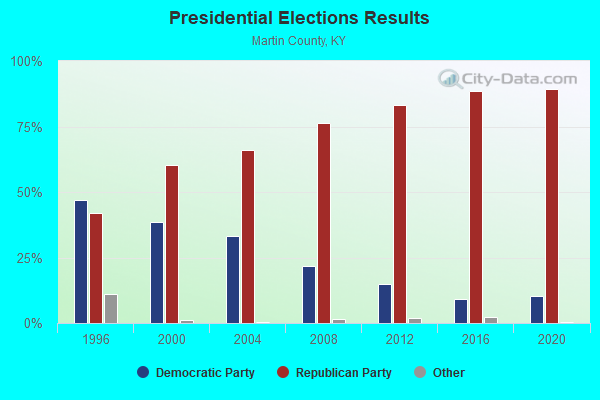
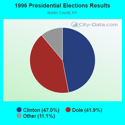
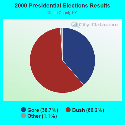
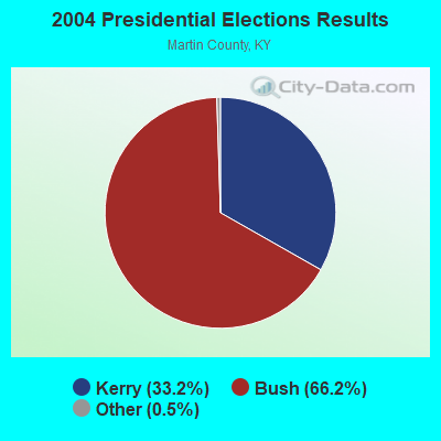


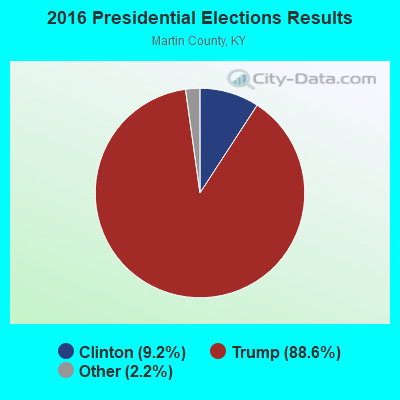
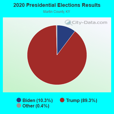
Graphs represent county-level data. Detailed 2008 Election Results
Religion statistics for Inez, KY (based on Martin County data)
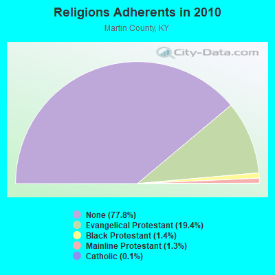
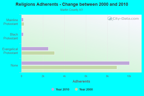
| Religion | Adherents | Congregations |
|---|---|---|
| Evangelical Protestant | 2,508 | 23 |
| Black Protestant | 179 | 1 |
| Mainline Protestant | 171 | 2 |
| Catholic | 13 | 1 |
| None | 10,058 | - |
Food Environment Statistics:
| This county: | 2.58 / 10,000 pop. |
| Kentucky: | 2.19 / 10,000 pop. |
| Here: | 1.72 / 10,000 pop. |
| Kentucky: | 0.74 / 10,000 pop. |
| This county: | 13.75 / 10,000 pop. |
| Kentucky: | 4.36 / 10,000 pop. |
| Martin County: | 3.44 / 10,000 pop. |
| Kentucky: | 5.74 / 10,000 pop. |
| This county: | 11.9% |
| Kentucky: | 11.0% |
| This county: | 36.0% |
| State: | 30.0% |
| Martin County: | 20.9% |
| Kentucky: | 15.9% |
Health and Nutrition:
| Inez: | 45.5% |
| State: | 49.9% |
| Here: | 50.7% |
| State: | 47.0% |
| This city: | 31.3 |
| State: | 28.6 |
| Here: | 12.2% |
| Kentucky: | 21.0% |
| This city: | 24.3% |
| Kentucky: | 10.1% |
| Inez: | 7.1 |
| State: | 6.8 |
| Here: | 41.4% |
| Kentucky: | 33.8% |
| This city: | 52.0% |
| Kentucky: | 56.8% |
| Inez: | 79.4% |
| Kentucky: | 78.9% |
More about Health and Nutrition of Inez, KY Residents
| Local government employment and payroll (March 2022) | |||||
| Function | Full-time employees | Monthly full-time payroll | Average yearly full-time wage | Part-time employees | Monthly part-time payroll |
|---|---|---|---|---|---|
| Solid Waste Management | 1 | $2,381 | $28,572 | 0 | $0 |
| Other Government Administration | 0 | $0 | 1 | $471 | |
| Totals for Government | 1 | $2,381 | $28,572 | 1 | $471 |
Inez government finances - Expenditure in 2017 (per resident):
- Construction - Regular Highways: $3,000 ($5.74)
- Current Operations - Regular Highways: $51,000 ($97.51)
Central Staff Services: $30,000 ($57.36)
Parks and Recreation: $4,000 ($7.65)
Police Protection: $3,000 ($5.74)
- General - Interest on Debt: $1,000 ($1.91)
- Total Salaries and Wages: $41,000 ($78.39)
Inez government finances - Revenue in 2017 (per resident):
- State Intergovernmental - Highways: $44,000 ($84.13)
Other: $28,000 ($53.54)
- Tax - Property: $74,000 ($141.49)
Public Utilities Sales: $4,000 ($7.65)
Other License: $4,000 ($7.65)
Other Selective Sales: $1,000 ($1.91)
Inez government finances - Debt in 2017 (per resident):
- Short Term Debt Outstanding - Beginning: $35,000 ($66.92)
End of Fiscal Year: $2,000 ($3.82)
Inez government finances - Cash and Securities in 2017 (per resident):
- Other Funds - Cash and Securities: $109,000 ($208.41)
| Businesses in Inez, KY | ||||
| Name | Count | Name | Count | |
|---|---|---|---|---|
| Advance Auto Parts | 1 | Rite Aid | 1 | |
| FedEx | 1 | Subway | 1 | |
| H&R Block | 1 | Super 8 | 1 | |
| KFC | 1 | Taco Bell | 1 | |
| McDonald's | 1 | UPS | 1 | |
| Papa John's Pizza | 1 | |||
Strongest AM radio stations in Inez:
- WKYH (600 AM; 5 kW; PAINTSVILLE, KY; Owner: HIGHLANDS BROADCASTING CORPORATION)
- WPRT (960 AM; 5 kW; PRESTONSBURG, KY; Owner: EAST KENTUCKY RADIO NETWORK, INC.)
- WDOC (1310 AM; 5 kW; PRESTONSBURG, KY)
- WLSI (900 AM; 5 kW; PIKEVILLE, KY; Owner: EAST KENTUCKY BROADCASTING CORPORATION)
- WTVN (610 AM; 50 kW; COLUMBUS, OH; Owner: CITICASTERS LICENSES, L.P.)
- WVHU (800 AM; 5 kW; HUNTINGTON, WV; Owner: CAPSTAR TX LIMITED PARTNERSHIP)
- WVOW (1290 AM; 5 kW; LOGAN, WV; Owner: LOGAN BROADCASTING CORPORATION)
- WSIP (1490 AM; 1 kW; PAINTSVILLE, KY; Owner: S.I.P. BROADCASTING COMPANY, INC.)
- WRVC (930 AM; 5 kW; HUNTINGTON, WV; Owner: FIFTH AVENUE BROADCASTING COMPANY, INC.)
- WCAW (680 AM; 10 kW; CHARLESTON, WV; Owner: WEST VIRGINIA RADIO CORPORATION OF CHARLESTON)
- WLW (700 AM; 50 kW; CINCINNATI, OH; Owner: JACOR BROADCASTING CORPORATION)
- WCHS (580 AM; 5 kW; CHARLESTON, WV; Owner: WEST VIRGINIA RADIO CORPORATION OF CHARLESTON)
- WKVL (850 AM; daytime; 50 kW; KNOXVILLE, TN; Owner: HORNE RADIO, LLC)
Strongest FM radio stations in Inez:
- WQHY (95.5 FM; PRESTONSBURG, KY; Owner: WDOC, INC.)
- WKLW-FM (94.7 FM; PAINTSVILLE, KY; Owner: B & G BROADCASTING, INC.)
- WSIP-FM (98.9 FM; PAINTSVILLE, KY; Owner: SIP BROADCASTING, INC.)
- WXLR (104.9 FM; HAROLD, KY; Owner: ADAM D GEARHEART)
- W202BH (88.3 FM; INEZ, KY; Owner: MOREHEAD STATE UNIVERSITY)
- WVKM (106.7 FM; MATEWAN, WV; Owner: THREE STATES BROADCASTING CO., INC.)
- WDHR (93.1 FM; PIKEVILLE, KY; Owner: EAST KENTUCKY BROADCASTING CORP.)
- WPKE-FM (103.1 FM; COAL RUN, KY; Owner: EAST KENTUCKY BROADCASTING CORP.)
- WXCC (96.5 FM; WILLIAMSON, WV; Owner: EAST KENTUCKY RADIO NETWORK, INC.)
- WKLC-FM (105.1 FM; ST. ALBANS, WV; Owner: WKLC, INC.)
- WVOW-FM (101.9 FM; LOGAN, WV; Owner: LOGAN BROADCASTING CORP.)
- WMDJ-FM (100.1 FM; ALLEN, KY; Owner: FLOYD COUNTY BROADCASTING CO., INC.)
- WIFX-FM (94.3 FM; JENKINS, KY; Owner: LETCHER COUNTY BROADCASTING, INC)
- WXKQ-FM (103.9 FM; WHITESBURG, KY; Owner: T.C.W. BROADCASTING , INC.)
- WMMT (88.7 FM; WHITESBURG, KY; Owner: APPALSHOP, INCORPORATED)
- WXKZ-FM (105.3 FM; PRESTONSBURG, KY; Owner: ADAM GEARHEART D/B/A WXLR-FM)
- WDXC (102.3 FM; POUND, VA; Owner: WDXC RADIO, INC.)
- WZLK (107.5 FM; VIRGIE, KY; Owner: EAST KENTUCKY BROADCASTING CORPORATION)
- WVWV (89.9 FM; HUNTINGTON, WV; Owner: WEST VIRGINIA EDUCATIONAL BROADCASTING AUTHORITY)
- WZAQ (92.3 FM; LOUISA, KY; Owner: LOUISA COMMUNICATIONS, INC.)
TV broadcast stations around Inez:
- WVAH-TV (Channel 11; CHARLESTON, WV; Owner: WVAH LICENSEE, LLC)
- WPBY-TV (Channel 33; HUNTINGTON, WV; Owner: WEST VIRGINIA EDUCATIONAL BROADCASTING AUTHORITY)
- WCHS-TV (Channel 8; CHARLESTON, WV; Owner: WCHS LICENSEE, LLC)
- Inez, Kentucky
- Fatal accident count13
- Vehicles involved in fatal accidents22
- Fatal accidents involving drunk persons:0
- Fatalities15
- Persons involved in fatal accidents28
- Pedestrians involved in fatal accidents1
- Kentucky average
- Fatal accident count8788
- Vehicles involved in fatal accidents13543
- Fatal accidents involving drunk persons2335
- Fatalities9687
- Persons involved in fatal accidents21109
- Pedestrians involved in fatal accidents959
- National Bridge Inventory (NBI) Statistics
- 47Number of bridges
- 545ft / 166mTotal length
- $2,060,000Total costs
- 73,267Total average daily traffic
- 3,833Total average daily truck traffic
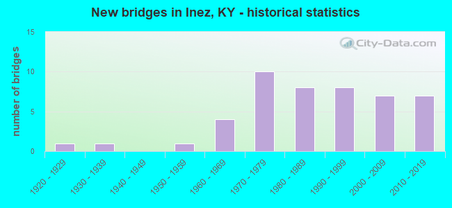
- New bridges - historical statistics
- 11920-1929
- 11930-1939
- 11950-1959
- 41960-1969
- 101970-1979
- 81980-1989
- 81990-1999
- 72000-2009
- 72010-2019
FCC Registered Cell Phone Towers:
3 (See the full list of FCC Registered Cell Phone Towers in Inez)FCC Registered Antenna Towers:
45 (See the full list of FCC Registered Antenna Towers)FCC Registered Broadcast Land Mobile Towers:
8 (See the full list of FCC Registered Broadcast Land Mobile Towers in Inez, KY)FCC Registered Microwave Towers:
6- INEZ, 3 Mi S Of Int Of Rt 3 & Rt 645 (Lat: 37.817222 Lon: -82.559972), Type: Tower, Structure height: 103.6 m, Overall height: 107 m, Call Sign: WPNB591,
Assigned Frequencies: 2112.00 MHz, Grant Date: 02/13/2001, Expiration Date: 02/01/2011, Cancellation Date: 04/26/2005, Certifier: Carol L Tacker, Registrant: Cingular Wireless LLC, 5565 Glenridge Connector, Suite 1700, Atlanta, GA 30342, Phone: (404) 236-5543, Fax: (404) 236-5575
- INEZ, Lat: 37.862389 Lon: -82.515500, Call Sign: WQGX381,
Assigned Frequencies: 956.356 MHz, Grant Date: 05/14/2007, Expiration Date: 05/14/2017, Cancellation Date: 07/15/2017, Certifier: Maurice Mills, Registrant: Sensus, 450 N Gallatin Ave, Uniontown, PA 15401, Phone: (800) 638-3748, Fax: (800) 888-2403, Email:
- Inez, 922 Inez Tower Road (Lat: 37.849417 Lon: -82.509694), Type: Ltower, Structure height: 39.6 m, Overall height: 40.2 m, Call Sign: WQRG313,
Assigned Frequencies: 6286.19 MHz, 6286.19 MHz, Grant Date: 05/07/2013, Expiration Date: 05/07/2023, Cancellation Date: 03/16/2023, Certifier: Gerald Robinette, Registrant: East Kentucky Network, 201 Technology Trail, Ivel, KY 41642, Phone: (606) 794-5254, Fax: (606) 794-4836, Email:
- Inez 2, Inez 2, 1.0 Km (0.6 Mi) Southwest Of (Lat: 37.860667 Lon: -82.548111), Type: Ltower, Structure height: 91.4 m, Overall height: 94.5 m, Call Sign: WQWW554,
Assigned Frequencies: 11645.0 MHz, 11645.0 MHz, 11645.0 MHz, 11645.0 MHz, 11645.0 MHz, 11645.0 MHz, 11645.0 MHz, Grant Date: 12/09/2015, Expiration Date: 12/09/2025, Certifier: Lynn Haney, Registrant: East Kentucky Network, LLC D/B/A Appalachian Wireless, 101 Technology Trail, Ivel, KY 41642, Phone: (606) 339-1006, Fax: (606) 339-1363, Email:
- STATION, 1 Mi N Of (Lat: 37.871472 Lon: -82.536806), Overall height: 97.5 m, Call Sign: KJD97,
Assigned Frequencies: 6825.00 MHz, 6855.00 MHz, Grant Date: 09/04/2019, Expiration Date: 11/03/2029, Cancellation Date: 03/23/2022, Certifier: Robert E Smith, Registrant: Spectrum And Licensing Services, 11 Lee Street, Hanover, PA 17331, Phone: (717) 630-0816, Fax: (717) 637-8300, Email:
- INEZ R, .5 Mi N (Lat: 37.874250 Lon: -82.538750), Overall height: 86.9 m, Call Sign: WLC877, Licensee ID: L00008228,
Assigned Frequencies: 11325.0 MHz, 11605.0 MHz, 6034.15 MHz, Grant Date: 08/22/2000, Expiration Date: 08/01/2010, Cancellation Date: 02/08/2002, Registrant: Bellsouth Telecommunications Incorporated, 22j64 Bsc 675 W Peachtree St Ne, Atlanta, GA 30375
FCC Registered Maritime Coast & Aviation Ground Towers:
1- Big Sandy Regional Airport (Lat: 37.749167 Lon: -82.641667), Type: Tower, Call Sign: KCV9,
Assigned Frequencies: 120.175 MHz, Grant Date: 02/06/2019, Expiration Date: 02/18/2029, Registrant: Business Radio Licensing, 30251 Golden Lantern Suite E, #501, Laguna Niguel, CA 92677, Phone: (949) 348-8510, Fax: (949) 348-8514, Email:
FCC Registered Amateur Radio Licenses:
37 (See the full list of FCC Registered Amateur Radio Licenses in Inez)| Most common first names in Inez, KY among deceased individuals | ||
| Name | Count | Lived (average) |
|---|---|---|
| James | 42 | 68.2 years |
| John | 32 | 70.1 years |
| William | 29 | 67.9 years |
| Mary | 25 | 78.5 years |
| Robert | 19 | 66.0 years |
| Charles | 12 | 62.8 years |
| Thomas | 11 | 76.3 years |
| George | 11 | 64.8 years |
| Paul | 10 | 50.9 years |
| Martin | 10 | 70.7 years |
| Most common last names in Inez, KY among deceased individuals | ||
| Last name | Count | Lived (average) |
|---|---|---|
| Maynard | 78 | 69.9 years |
| Horn | 55 | 76.6 years |
| Mills | 43 | 70.8 years |
| Preece | 40 | 75.0 years |
| Stepp | 40 | 73.8 years |
| Crum | 34 | 68.2 years |
| Moore | 33 | 70.2 years |
| Bowen | 30 | 67.4 years |
| Ward | 29 | 73.4 years |
| Goble | 24 | 74.2 years |
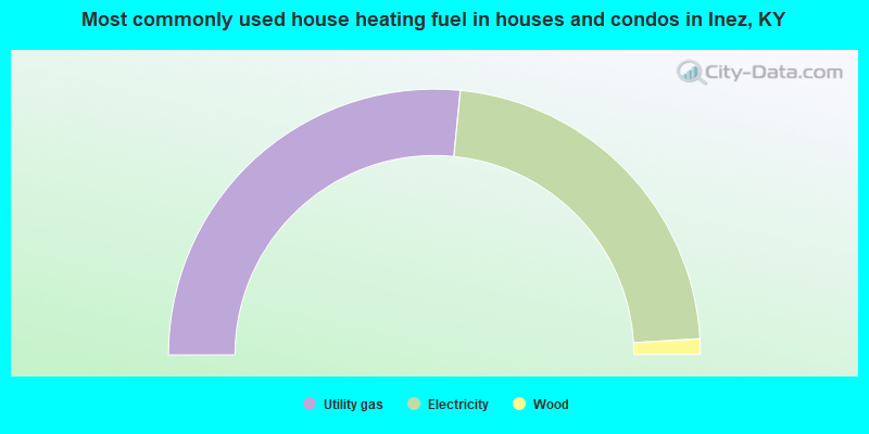
- 53.1%Utility gas
- 45.0%Electricity
- 1.9%Wood
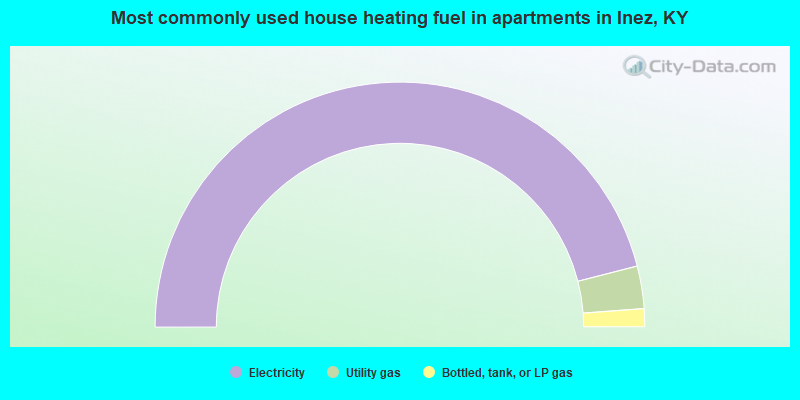
- 92.0%Electricity
- 5.6%Utility gas
- 2.4%Bottled, tank, or LP gas
Inez compared to Kentucky state average:
- Median household income below state average.
- Median house value significantly below state average.
- Black race population percentage significantly below state average.
- Hispanic race population percentage significantly below state average.
- Median age above state average.
- Foreign-born population percentage significantly below state average.
- Length of stay since moving in significantly above state average.
- Institutionalized population percentage significantly above state average.