Jay, Vermont
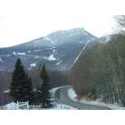
Submit your own pictures of this town and show them to the world
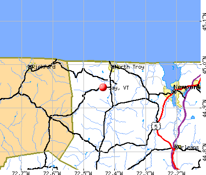
- OSM Map
- General Map
- Google Map
- MSN Map
Population change since 2000: +22.3%
| Males: 272 | |
| Females: 249 |
| Median resident age: | 41.3 years |
| Vermont median age: | 45.8 years |
Zip codes: 05859.
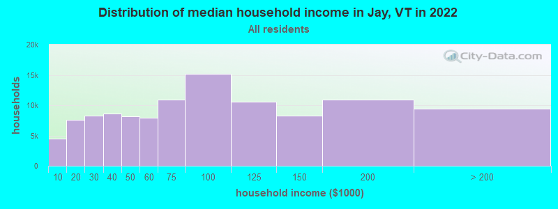
| Jay: | $66,506 |
| VT: | $73,991 |
Estimated per capita income in 2022: $28,568 (it was $13,546 in 2000)
Jay town income, earnings, and wages data
Estimated median house or condo value in 2022: $230,972 (it was $86,500 in 2000)
| Jay: | $230,972 |
| VT: | $304,700 |
Mean prices in 2022: all housing units: $271,502; detached houses: $290,446; townhouses or other attached units: $299,602; in 2-unit structures: $159,589; in 3-to-4-unit structures: $395,771; in 5-or-more-unit structures: $253,965; mobile homes: $74,912
Detailed information about poverty and poor residents in Jay, VT


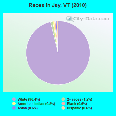
- 50296.4%White alone
- 61.2%Two or more races
- 40.8%American Indian alone
- 30.6%Black alone
- 30.6%Asian alone
- 30.6%Hispanic
Races in Jay detailed stats: ancestries, foreign born residents, place of birth
According to our research of Vermont and other state lists, there was 1 registered sex offender living in Jay, Vermont as of April 29, 2024.
The ratio of all residents to sex offenders in Jay is 521 to 1.
The ratio of registered sex offenders to all residents in this city is near the state average.
 Recent articles from our blog. Our writers, many of them Ph.D. graduates or candidates, create easy-to-read articles on a wide variety of topics.

 | Stowe vs. Jay Peak for Photographer, Snow Lover, Beginner Skier (9 replies) |
| Jay Peak Ski Resort question (4 replies) |
| Mad River Valley? Questions on possible relocation... (30 replies) |
| Jay Peak's expansion. Why is it doing so well and expnading? (23 replies) |
| Wages at Jay Peak (1 reply) |
| Unexpected job offer in Vermont (28 replies) |
Latest news from Jay, VT collected exclusively by city-data.com from local newspapers, TV, and radio stations
Ancestries: French (24.9%), Irish (17.1%), English (14.6%), German (9.9%), French Canadian (5.4%), United States (4.2%).
Current Local Time: EST time zone
Elevation: 918 feet
Land area: 33.9 square miles.
Population density: 15 people per square mile (very low).
45 residents are foreign born (9.4% North America).
| This town: | 10.6% |
| Vermont: | 3.8% |
| Jay town: | 1.5% ($1,280) |
| Vermont: | 2.0% ($2,196) |
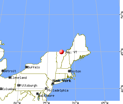
Nearest city with pop. 50,000+: Portland, ME  (140.8 miles , pop. 64,249).
Nearest city with pop. 200,000+: Boston, MA (195.3 miles , pop. 589,141).
Nearest city with pop. 1,000,000+: Bronx, NY (293.7 miles , pop. 1,332,650).
Nearest cities:
), ), ), ), ), Latitude: 44.97 N, Longitude: 72.46 W
Area code commonly used in this area: 802

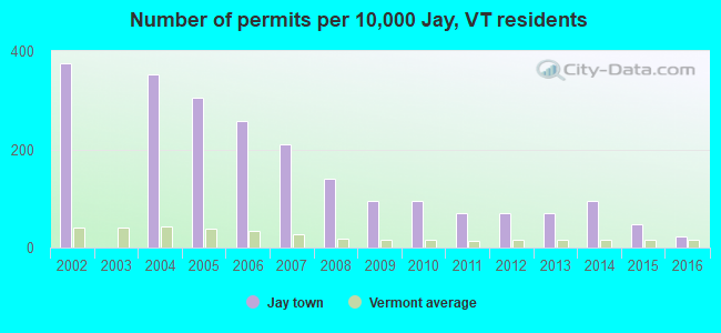
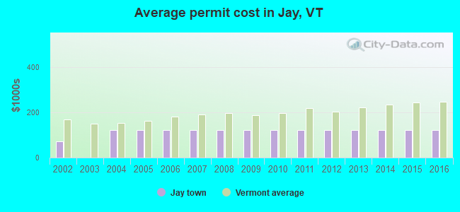
Single-family new house construction building permits:
- 2016: 1 building, cost: $121,800
- 2015: 2 buildings, average cost: $121,800
- 2014: 4 buildings, average cost: $121,800
- 2013: 3 buildings, average cost: $121,800
- 2012: 3 buildings, average cost: $121,800
- 2011: 3 buildings, average cost: $121,800
- 2010: 4 buildings, average cost: $121,800
- 2009: 4 buildings, average cost: $121,800
- 2008: 6 buildings, average cost: $121,800
- 2007: 9 buildings, average cost: $121,800
- 2006: 11 buildings, average cost: $121,800
- 2005: 13 buildings, average cost: $121,800
- 2004: 15 buildings, average cost: $121,800
- 2002: 16 buildings, average cost: $72,500
| Here: | 3.5% |
| Vermont: | 2.0% |
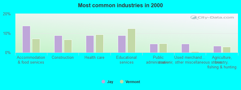
- Accommodation & food services (13.9%)
- Construction (8.9%)
- Health care (8.9%)
- Educational services (8.9%)
- Public administration (4.5%)
- Used merchandise, gift, novelty, souvenir, other miscellaneous stores (4.5%)
- Agriculture, forestry, fishing & hunting (3.5%)
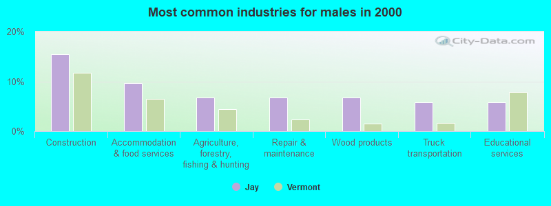
- Construction (15.4%)
- Accommodation & food services (9.6%)
- Agriculture, forestry, fishing & hunting (6.7%)
- Repair & maintenance (6.7%)
- Wood products (6.7%)
- Truck transportation (5.8%)
- Educational services (5.8%)
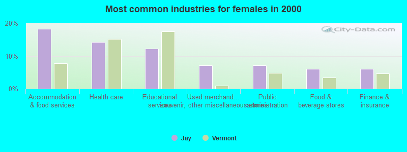
- Accommodation & food services (18.4%)
- Health care (14.3%)
- Educational services (12.2%)
- Used merchandise, gift, novelty, souvenir, other miscellaneous stores (7.1%)
- Public administration (7.1%)
- Food & beverage stores (6.1%)
- Finance & insurance (6.1%)
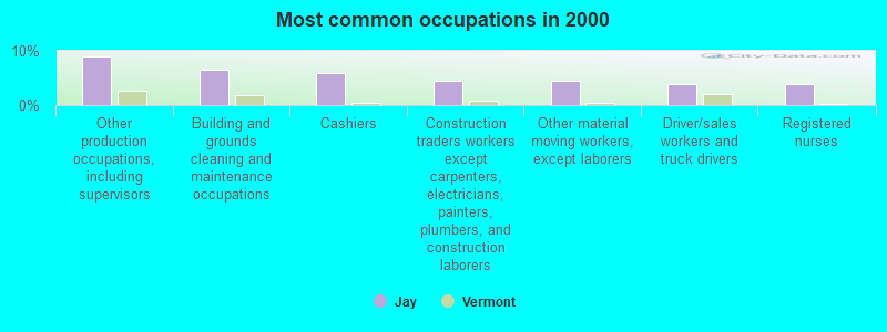
- Other production occupations, including supervisors (8.9%)
- Building and grounds cleaning and maintenance occupations (6.4%)
- Cashiers (5.9%)
- Construction traders workers except carpenters, electricians, painters, plumbers, and construction laborers (4.5%)
- Other material moving workers, except laborers (4.5%)
- Driver/sales workers and truck drivers (4.0%)
- Registered nurses (4.0%)
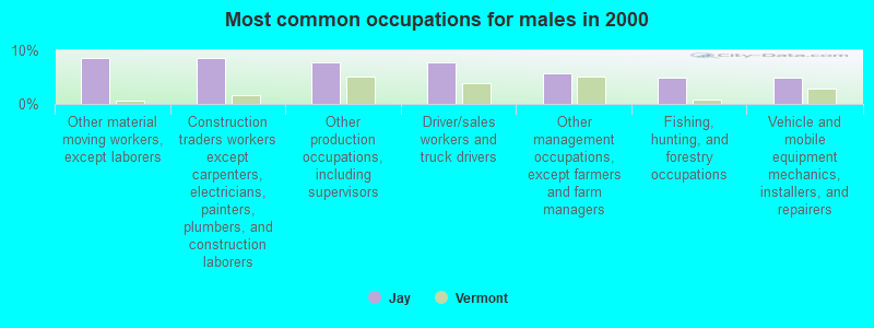
- Other material moving workers, except laborers (8.7%)
- Construction traders workers except carpenters, electricians, painters, plumbers, and construction laborers (8.7%)
- Other production occupations, including supervisors (7.7%)
- Driver/sales workers and truck drivers (7.7%)
- Other management occupations, except farmers and farm managers (5.8%)
- Fishing, hunting, and forestry occupations (4.8%)
- Vehicle and mobile equipment mechanics, installers, and repairers (4.8%)
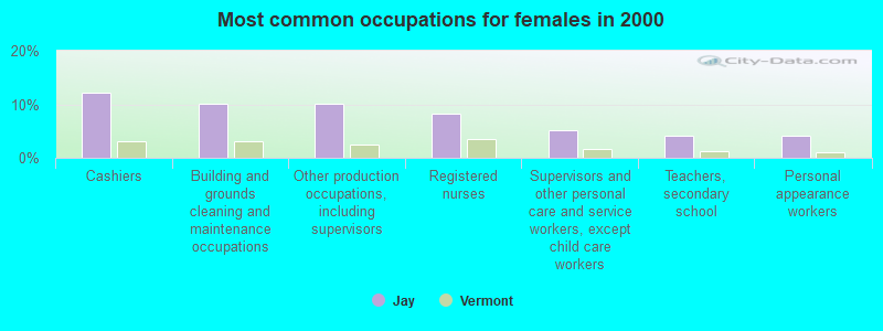
- Cashiers (12.2%)
- Building and grounds cleaning and maintenance occupations (10.2%)
- Other production occupations, including supervisors (10.2%)
- Registered nurses (8.2%)
- Supervisors and other personal care and service workers, except child care workers (5.1%)
- Teachers, secondary school (4.1%)
- Personal appearance workers (4.1%)
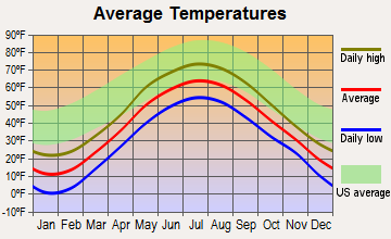
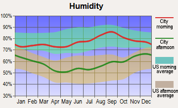
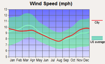
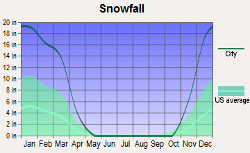
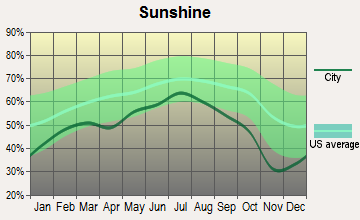
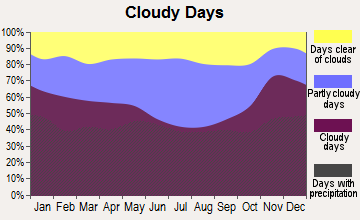
Average climate in Jay, Vermont
Based on data reported by over 4,000 weather stations
Earthquake activity:
Jay-area historical earthquake activity is significantly above Vermont state average. It is 77% smaller than the overall U.S. average.On 4/20/2002 at 10:50:47, a magnitude 5.3 (5.3 ML, Depth: 3.0 mi, Class: Moderate, Intensity: VI - VII) earthquake occurred 68.4 miles away from the city center
On 4/20/2002 at 10:50:47, a magnitude 5.2 (5.2 MB, 4.2 MS, 5.2 MW, 5.0 MW) earthquake occurred 70.1 miles away from Jay center
On 10/7/1983 at 10:18:46, a magnitude 5.3 (5.1 MB, 5.3 LG, 5.1 ML) earthquake occurred 116.3 miles away from Jay center
On 1/19/1982 at 00:14:42, a magnitude 4.7 (4.5 MB, 4.7 MD, 4.5 LG, Class: Light, Intensity: IV - V) earthquake occurred 109.9 miles away from the city center
On 10/16/2012 at 23:12:25, a magnitude 4.7 (4.7 ML, Depth: 10.0 mi) earthquake occurred 130.1 miles away from the city center
On 6/16/1995 at 12:13:11, a magnitude 3.8 (3.8 LG, Depth: 3.1 mi, Class: Light, Intensity: II - III) earthquake occurred 54.1 miles away from Jay center
Magnitude types: regional Lg-wave magnitude (LG), body-wave magnitude (MB), duration magnitude (MD), local magnitude (ML), surface-wave magnitude (MS), moment magnitude (MW)
Natural disasters:
The number of natural disasters in Orleans County (23) is greater than the US average (15).Major Disasters (Presidential) Declared: 17
Emergencies Declared: 2
Causes of natural disasters: Floods: 16, Storms: 14, Tropical Storms: 2, Winds: 2, Winter Storms: 2, Heavy Rain: 1, Hurricane: 1, Landslide: 1, Snowstorm: 1, Tornado: 1, Other: 1 (Note: some incidents may be assigned to more than one category).
Hospitals and medical centers near Jay:
- FLETCHER ALLEN HEALTHCARE - NORTH COUNTRY DIALYSIS UNIT (Dialysis Facility, about 13 miles away; NEWPORT, VT)
- NORTH COUNTRY HOSPITAL AND HEALTH CENTER Critical Access Hospitals (about 13 miles away; NEWPORT, VT)
- ORLEANS ESSEX VNA AND HOSPICE (Home Health Center, about 13 miles away; NEWPORT, VT)
- NEWPORT HEALTH CARE CENTER (Nursing Home, about 13 miles away; NEWPORT, VT)
Colleges/universities with over 2000 students nearest to Jay:
- Saint Michael's College (about 48 miles; Colchester, VT; Full-time enrollment: 2,336)
- Community College of Vermont (about 49 miles; Winooski, VT; FT enrollment: 3,394)
- University of Vermont (about 50 miles; Burlington, VT; FT enrollment: 11,566)
- Champlain College (about 50 miles; Burlington, VT; FT enrollment: 2,623)
- SUNY College at Plattsburgh (about 53 miles; Plattsburgh, NY; FT enrollment: 5,934)
- Norwich University (about 58 miles; Northfield, VT; FT enrollment: 4,221)
- Middlebury College (about 75 miles; Middlebury, VT; FT enrollment: 3,077)
Private high school in Jay:
Public elementary/middle school in Jay:
- JAY/WESTFIELD JOINT ELEMENTARY SCHOOL (Students: 65, Location: 257 REVOIR FLATS ROAD, Grades: PK-6)
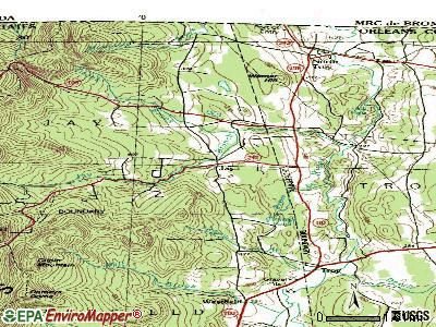
Points of interest:
Notable locations in Jay: Laura Woodward Camp (A), Journeys End Camp (B), Jay Volunteer Fire Department (C), Missisquoi Valley Ambulance Service (D). Display/hide their locations on the map
Cemetery: Jay Center Cemetery (1). Display/hide its location on the map
Streams, rivers, and creeks: Crook Brook (A). Display/hide its location on the map
Drinking water stations with addresses in Jay and their reported violations in the past:
JAY PEAK WATER SYSTEM (Address: 830 JAY PEAK ROAD , Population served: 2,122, Groundwater):Past monitoring violations:JAY WESTFIELD ELEMENTARY SCHOOL (Address: 257 REVOIR FLATS , Population served: 90, Groundwater):
- Follow-up Or Routine LCR Tap M/R - In JAN-01-1998, Contaminant: Lead and Copper Rule. Follow-up actions: St Violation/Reminder Notice (JUL-01-1998), St Public Notif requested (JUL-01-1998)
- 25 regular monitoring violations
Past health violations:JAY VILLAGE INN 242 TAP GRILLE (Address: 1078 RT 242 , Population served: 80, Groundwater):Past monitoring violations:
- MCL, Monthly (TCR) - In JUN-2014, Contaminant: Coliform. Follow-up actions: St Boil Water Order (JUN-19-2014), St Tech Assistance Visit (JUN-19-2014), St Public Notif requested (JUN-19-2014), St Formal NOV issued (JUN-19-2014)
- MCL, Monthly (TCR) - In APR-2011, Contaminant: Coliform. Follow-up actions: St Tech Assistance Visit (MAY-02-2011), St Formal NOV issued (MAY-02-2011), St Public Notif requested (MAY-02-2011), St Boil Water Order (MAY-02-2011), St Compliance achieved (NOV-02-2012)
- MCL, Monthly (TCR) - In AUG-2010, Contaminant: Coliform. Follow-up actions: St Tech Assistance Visit (MAR-29-2011), St Formal NOV issued (MAR-29-2011), St Public Notif requested (MAR-29-2011), St Boil Water Order (MAR-29-2011), St Compliance achieved (NOV-02-2012)
- Monitoring and Reporting (DBP) - Between JUL-2008 and SEP-2008, Contaminant: Chlorine. Follow-up actions: St Compliance achieved (JAN-30-2009), St Public Notif requested (APR-07-2009), St Formal NOV issued (APR-07-2009)
- Monitoring and Reporting (DBP) - Between APR-2008 and JUN-2008, Contaminant: Chlorine. Follow-up actions: St Public Notif requested (JAN-15-2009), St Formal NOV issued (JAN-15-2009), St Compliance achieved (JAN-30-2009)
- Follow-up Or Routine LCR Tap M/R - In OCT-01-2006, Contaminant: Lead and Copper Rule. Follow-up actions: St Public Notif requested (DEC-04-2006), St Formal NOV issued (DEC-04-2006), St Compliance achieved (APR-26-2011)
- Follow-up Or Routine LCR Tap M/R - In JAN-01-1999, Contaminant: Lead and Copper Rule
- Follow-up Or Routine LCR Tap M/R - In JAN-01-1999, Contaminant: Lead and Copper Rule. Follow-up actions: St Public Notif requested (JUL-01-1999), St Violation/Reminder Notice (JUL-01-1999), St Public Notif received (DEC-20-1999), St Compliance achieved (APR-26-2011)
- One regular monitoring violation
Past monitoring violations:JAY PEAK MOUNTAINSIDE CONDOS (Address: 830 JAY PEAK ROAD , Population served: 69, Groundwater):
- 7 routine major monitoring violations
Past monitoring violations:JAY PEAK SUBDIVISION II (Address: 830 JAY PEAK ROAD , Population served: 66, Groundwater):
- One routine major monitoring violation
- One regular monitoring violation
Past monitoring violations:INGLENOOK LODGE (Address: 830 JAY PEAK ROAD , Population served: 48, Groundwater):
- Follow-up Or Routine LCR Tap M/R - In OCT-01-2008, Contaminant: Lead and Copper Rule. Follow-up actions: St Formal NOV issued (DEC-08-2008), St Tech Assistance Visit (DEC-08-2008), St Public Notif requested (DEC-08-2008), St Other (DEC-08-2008), St Compliance achieved (DEC-12-2008)
- Follow-up Or Routine LCR Tap M/R - In JUL-01-2004, Contaminant: Lead and Copper Rule. Follow-up actions: St Public Notif requested (DEC-02-2004), St Formal NOV issued (DEC-02-2004), St Public Notif received (DEC-20-2004), St Compliance achieved (JAN-25-2011)
- Follow-up Or Routine LCR Tap M/R - In JAN-01-1999, Contaminant: Lead and Copper Rule. Follow-up actions: St Public Notif requested (JAN-01-2000), St Violation/Reminder Notice (JAN-01-2000), St Public Notif received (JUN-17-2000), St Compliance achieved (JAN-25-2011)
- Follow-up Or Routine LCR Tap M/R - In JAN-01-1999, Contaminant: Lead and Copper Rule
- Follow-up Or Routine LCR Tap M/R - In JAN-01-1998, Contaminant: Lead and Copper Rule. Follow-up actions: St Public Notif requested (JUL-01-1998), St Violation/Reminder Notice (JUL-01-1998), St Compliance achieved (JAN-25-2011)
- One regular monitoring violation
- One other older monitoring violation
Past monitoring violations:SNOWLINE (Address: 830 JAY PEAK ROAD , Population served: 45, Groundwater):
- Monitoring, Repeat Major (TCR) - Between JUL-2010 and SEP-2010, Contaminant: Coliform (TCR). Follow-up actions: St Public Notif requested (NOV-02-2010), St Formal NOV issued (NOV-02-2010), St Compliance achieved (AUG-08-2013)
- 9 routine major monitoring violations
- 3 regular monitoring violations
Past health violations:TRILLIUM WOODS WATER SYSTEM (Address: 3277 VT RTE 242 , Population served: 27, Groundwater):Past monitoring violations:
- MCL, Monthly (TCR) - In FEB-2007, Contaminant: Coliform. Follow-up actions: St Boil Water Order (FEB-23-2007), St Formal NOV issued (FEB-23-2007), St Tech Assistance Visit (FEB-23-2007), St Public Notif requested (FEB-23-2007), St Public Notif received (MAR-01-2007), St Compliance achieved (SEP-25-2009)
- MCL, Monthly (TCR) - In DEC-2006, Contaminant: Coliform. Follow-up actions: St Tech Assistance Visit (DEC-29-2006), St Formal NOV issued (DEC-29-2006), St Public Notif requested (DEC-29-2006), St Boil Water Order (DEC-29-2006), St Compliance achieved (APR-30-2007)
- One minor monitoring violation
Past monitoring violations:
- Monitoring and Reporting (DBP) - Between OCT-2009 and DEC-2009, Contaminant: Chlorine. Follow-up actions: St Formal NOV issued (MAR-01-2010), St Compliance achieved (MAR-22-2011)
| This town: | 2.3 people |
| Vermont: | 2.3 people |
| This town: | 63.7% |
| Whole state: | 62.5% |
| This town: | 12.6% |
| Whole state: | 9.2% |
Likely homosexual households (counted as self-reported same-sex unmarried-partner households)
- Lesbian couples: 0.4% of all households
- Gay men: 1.3% of all households
| This town: | 12.4% |
| Whole state: | 9.4% |
| This town: | 6.1% |
| Whole state: | 3.6% |
For population 15 years and over in Jay:
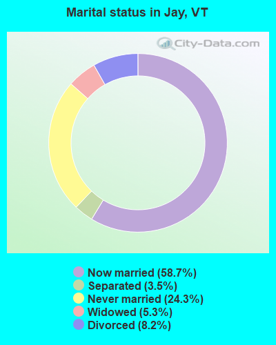
- Never married: 24.3%
- Now married: 58.7%
- Separated: 3.5%
- Widowed: 5.3%
- Divorced: 8.2%
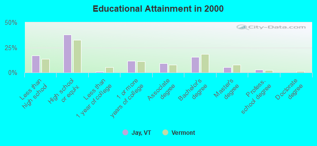
For population 25 years and over in Jay:
- High school or higher: 83.0%
- Bachelor's degree or higher: 24.0%
- Graduate or professional degree: 8.5%
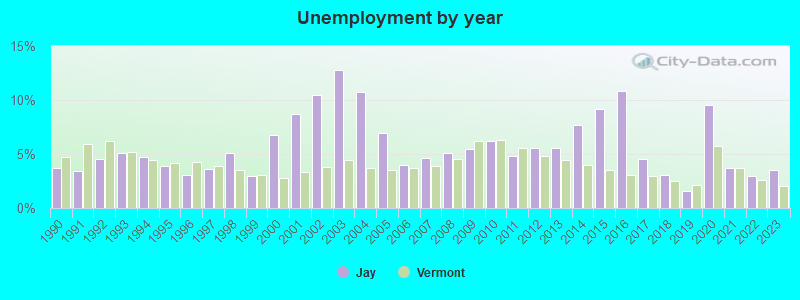
- Unemployed: 5.2%
- Mean travel time to work (commute): 27.9 minutes
| Here: | 12.0 |
| Vermont average: | 11.7 |
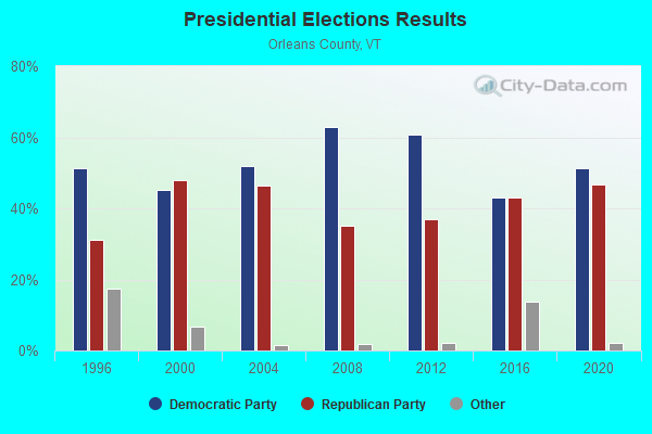
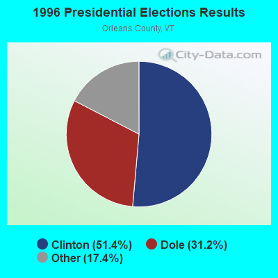
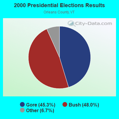
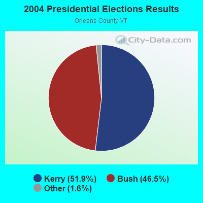
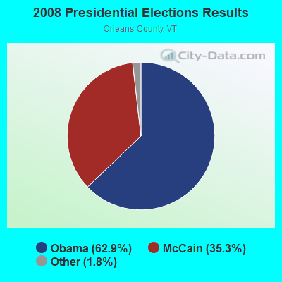
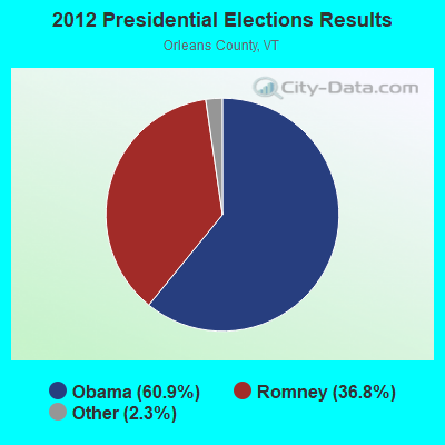


Graphs represent county-level data. Detailed 2008 Election Results
Religion statistics for Jay, VT (based on Orleans County data)
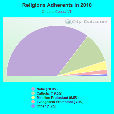
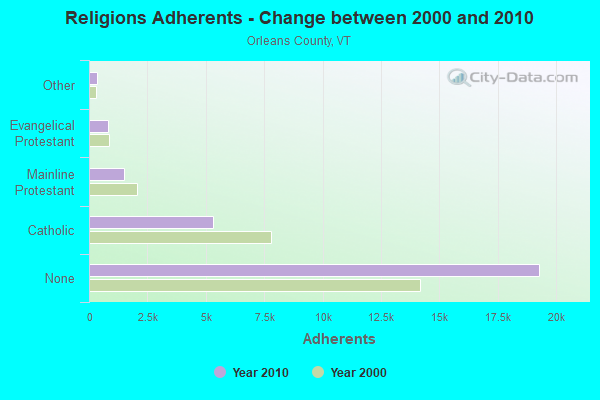
| Religion | Adherents | Congregations |
|---|---|---|
| Catholic | 5,312 | 12 |
| Mainline Protestant | 1,485 | 23 |
| Evangelical Protestant | 822 | 14 |
| Other | 323 | 4 |
| None | 19,289 | - |
Food Environment Statistics:
| Orleans County: | 5.14 / 10,000 pop. |
| Vermont: | 3.84 / 10,000 pop. |
| Orleans County: | 1.10 / 10,000 pop. |
| Vermont: | 1.95 / 10,000 pop. |
| Here: | 6.60 / 10,000 pop. |
| Vermont: | 6.40 / 10,000 pop. |
| Orleans County: | 8.07 / 10,000 pop. |
| Vermont: | 11.52 / 10,000 pop. |
| Orleans County: | 7.0% |
| Vermont: | 6.8% |
| Here: | 24.8% |
| State: | 22.3% |
| Orleans County: | 10.8% |
| Vermont: | 13.3% |
Strongest AM radio stations in Jay:
- WCHP (760 AM; 35 kW; CHAMPLAIN, NY; Owner: CHAMPLAIN RADIO, INC.)
- WIKE (1490 AM; 1 kW; NEWPORT, VT; Owner: NORTHSTAR MEDIA, INC.)
- WICY (1490 AM; 50 kW; MALONE, NY; Owner: CARTIER COMMUNICATIONS INC.)
- WDEV (550 AM; 5 kW; WATERBURY, VT; Owner: RADIO VERMONT, INC.)
- WVMT (620 AM; 5 kW; BURLINGTON, VT; Owner: SISON BROADCASTING, INC.)
- WRKO (680 AM; 50 kW; BOSTON, MA; Owner: ENTERCOM BOSTON LICENSE, LLC)
- WGY (810 AM; 50 kW; SCHENECTADY, NY; Owner: CLEAR CHANNEL BROADCASTING LICENSES, INC.)
- WNNZ (640 AM; 50 kW; WESTFIELD, MA; Owner: CLEAR CHANNEL BROADCASTING LICENSES, INC.)
- WEAV (960 AM; 5 kW; PLATTSBURGH, NY; Owner: CLEAR CHANNEL BROADCASTING LICENSES, INC.)
- WCRN (830 AM; 50 kW; WORCESTER, MA; Owner: CARTER BROADCASTING CORPORATION)
- WTWK (1070 AM; daytime; 5 kW; PLATTSBURGH, NY; Owner: CHAMPLAIN COMMUNICATIONS CORPORATION)
- WVAA (1390 AM; 5 kW; BURLINGTON, VT; Owner: RADIO VERMONT, KDR, LLC)
- WEEI (850 AM; 50 kW; BOSTON, MA; Owner: ENTERCOM BOSTON LICENSE, LLC)
Strongest FM radio stations in Jay:
- WLKC (103.3 FM; WATERBURY, VT; Owner: RADIO BROADCASTING SERVICES, INC.)
- WEZF (92.9 FM; BURLINGTON, VT; Owner: CAPSTAR TX LIMITED PARTNERSHIP)
- WVPS (107.9 FM; BURLINGTON, VT; Owner: VERMONT PUBLIC RADIO)
- WCVT (101.7 FM; STOWE, VT; Owner: RADIO VERMONT CLASSICS, L.L.C.)
- WNCS (104.7 FM; MONTPELIER, VT; Owner: MONTPELIER BROADCASTING, INC.)
- WGMT (97.7 FM; LYNDON, VT; Owner: VERMONT BROADCAST ASSOCIATES, INC.)
- WMOO (92.1 FM; DERBY CENTER, VT; Owner: NORTHSTAR MEDIA, INC.)
- WPKQ (103.7 FM; NORTH CONWAY, NH; Owner: CITADEL BROADCASTING COMPANY)
- WHOM (94.9 FM; MT. WASHINGTON, NH; Owner: CITADEL BROADCASTING COMPANY)
- W243AE (96.5 FM; ORLEANS, VT; Owner: CHRISTIAN MINISTRIES, INC.)
- WCEL (91.9 FM; PLATTSBURGH, NY; Owner: WAMC)
- WDEV-FM (96.1 FM; WARREN, VT; Owner: RADIO VERMONT, INC.)
- WLFE-FM (102.3 FM; ST. ALBANS, VT; Owner: CHAMPLAIN COMMUNICATIONS CORP.)
- WDOT (95.7 FM; DANVILLE, VT; Owner: MONTPELIER BROADCASTING INC)
- National Bridge Inventory (NBI) Statistics
- 11Number of bridges
- 46ft / 13.6mTotal length
- $1,333,000Total costs
- 5,315Total average daily traffic
- 379Total average daily truck traffic
- 5,583Total future (year 2025) average daily traffic
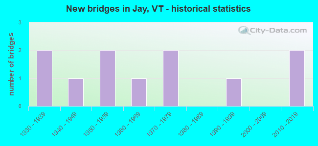
- New bridges - historical statistics
- 21930-1939
- 11940-1949
- 21950-1959
- 11960-1969
- 21970-1979
- 11990-1999
- 22010-2019
FCC Registered Cell Phone Towers:
2- Jay Peak Tram House Building (Lat: 44.924222 Lon: -72.525667), Type: Building, Structure height: 12.3 m, Overall height: 19.3 m, Call Sign: KNKQ284
Assigned Frequencies: 880.020 MHz, 880.020 MHz, 835.020 MHz, 835.020 MHz, 891.510 MHz, 891.510 MHz, 846.510 MHz, 846.510 MHz, 880.020 MHz, 880.020 MHz... (+6 more)Grant Date: 08/31/2021, Expiration Date: 10/01/2031, Certifier: Gregory M RomanoRegistrant: Verizon Wireless, 5055 North Point Pkwy, Np2ne Network Engineering, Alpharetta, GA 30022, Phone: (770) 797-1070, Email:
- (Jay Peak Site) Atop Jay Peak Route 242 (Lat: 44.924222 Lon: -72.525667), Type: Building, Structure height: 12.3 m, Overall height: 19.3 m, Call Sign: KNKA695
Assigned Frequencies: 880.020 MHz, 880.020 MHz, 880.020 MHz, 880.020 MHz, 835.020 MHz, 835.020 MHz, 835.020 MHz, 835.020 MHz, 891.510 MHz, 891.510 MHz... (+6 more)Grant Date: 10/23/2018, Expiration Date: 11/27/2028, Certifier: Gregory M RomanoRegistrant: Verizon, 1300 I Street Nw - Suite 500 East, Washington, DC 20005, Phone: (202) 515-2453, Email:
FCC Registered Private Land Mobile Towers:
1- Jay Peak (Lat: 44.923667 Lon: -72.525389), Structure height: 15 m, Call Sign: WNNB421,
Assigned Frequencies: 152.480 MHz, Grant Date: 06/15/2021, Expiration Date: 07/09/2031, Certifier: Kathy M Paskevich, Registrant: Jkl Communications LLC, 142 Avenue C, Williston, VT 05495, Phone: (802) 860-0000, Fax: (802) 860-5037, Email:
FCC Registered Broadcast Land Mobile Towers:
5- 500 S Of Route 242 (Lat: 44.944500 Lon: -72.438444), Call Sign: KNFA381,
Assigned Frequencies: 154.205 MHz, 154.295 MHz, Grant Date: 12/31/2011, Expiration Date: 03/17/2022, Cancellation Date: 05/21/2022, Registrant: Burlington Communications, 4735 Williston Rd, Williston, VT 05495, Phone: (802) 862-7092, Email:
- Lat: 44.948861 Lon: -72.430028, Call Sign: WQCB632,
Assigned Frequencies: 452.187 MHz, 457.187 MHz, Grant Date: 01/25/2005, Expiration Date: 01/25/2015, Cancellation Date: 03/28/2015, Certifier: Bill Stenger, Registrant: Cara Enterprises Inc, Salt Lake City, UT 84117-0503, Phone: (801) 278-9728, Fax: (801) 278-7239
- Tramway Building, Jay Peak (Lat: 44.924167 Lon: -72.525833), Type: Building, Structure height: 10 m, Call Sign: WQFU326,
Assigned Frequencies: 460.587 MHz, Grant Date: 03/13/2007, Expiration Date: 09/09/2007, Cancellation Date: 11/10/2007, Certifier: Terry M Lavalley, Registrant: State Of Vermont, 103 South Main Street, Waterbury, VT 05671, Phone: (802) 244-8786, Fax: (802) 241-5557, Email:
- Tramway Building, Jay Peak (Lat: 44.924167 Lon: -72.525833), Type: Bant, Structure height: 8 m, Overall height: 9 m, Call Sign: WQXH813,
Assigned Frequencies: 460.587 MHz, Grant Date: 03/09/2016, Expiration Date: 09/05/2016, Cancellation Date: 11/12/2016, Certifier: Terry M Lavalley, Registrant: State Of Vermont, 45 State Drive, Waterbury, VT 05671, Phone: (802) 241-5215, Fax: (802) 241-5557, Email:
- Tramway Building, Jay Peak (Lat: 44.924167 Lon: -72.525833), Type: Bant, Structure height: 8 m, Overall height: 9 m, Call Sign: WQYH971,
Assigned Frequencies: 460.587 MHz, Grant Date: 10/05/2016, Expiration Date: 10/05/2026, Certifier: Terry M Lavalley, Registrant: State Of Vermont, 45 State Drive, Watterbury, VT 05671, Phone: (802) 229-0882, Fax: (802) 241-5557, Email:
FCC Registered Microwave Towers:
3- JAY PEAK, 263 Westover Rd (Lat: 44.924222 Lon: -72.525667), Type: Tower, Structure height: 12.3 m, Overall height: 19.3 m, Call Sign: WQIM441,
Assigned Frequencies: 10563.1 MHz, Grant Date: 03/18/2008, Expiration Date: 03/18/2018, Cancellation Date: 02/20/2014, Certifier: Pamelia Y Hoof, Registrant: Verizon Wireless, 1120 Sanctuary Pkwy, #150 Gasa5reg, Alpharetta, GA 30009-7630, Phone: (770) 797-1070, Fax: (770) 797-1036, Email:
- JAY PEAK, Jay Peak Tram House Bulding Rt. 242 (Lat: 44.924222 Lon: -72.525667), Type: Building, Structure height: 12.3 m, Overall height: 19.3 m, Call Sign: WQUZ377,
Assigned Frequencies: 6226.89 MHz, Grant Date: 11/25/2014, Expiration Date: 11/25/2024, Cancellation Date: 08/17/2015, Certifier: Steven A Regitz, Registrant: Verizon Wireless, 1120 Sanctuary Pkwy, #150 Gasa5reg, Alpharetta, GA 30009-7630, Phone: (770) 797-1070, Fax: (770) 797-1036, Email:
- Jay-02, 830 Jay Peak Rd (Lat: 44.924361 Lon: -72.525861), Type: Building, Structure height: 9.1 m, Overall height: 15.2 m, Call Sign: WQWW497,
Assigned Frequencies: 11465.0 MHz, 11465.0 MHz, 11225.0 MHz, 11265.0 MHz, 11385.0 MHz, 11385.0 MHz, 11225.0 MHz, 11265.0 MHz, 11465.0 MHz, 11465.0 MHz... (+88 more), Grant Date: 12/09/2015, Expiration Date: 12/09/2025, Certifier: Fran Stocker, Registrant: Radyn, Inc, Silver Spring, MD 20914, Phone: (301) 493-5171, Fax: (301) 576-4553, Email:
FCC Registered Paging Towers:
2- Jay Peak, 5 Miles West Of (Lat: 44.924194 Lon: -72.525944), Structure height: 18 m, Call Sign: KDS417,
Assigned Frequencies: 152.030 MHz, Grant Date: 04/02/2019, Expiration Date: 04/01/2029, Certifier: Gerald W Blanchard, Registrant: Keller And Heckman LLP, 1001 G Street Nw, Suite 500 West, Washington, DC 20001, Phone: (202) 434-4100, Fax: (202) 434-4646, Email:
- Jay Peak, 5 Miles West Of (Lat: 44.924194 Lon: -72.525944), Call Sign: KNKM505,
Assigned Frequencies: 152.030 MHz, Grant Date: 04/02/2019, Expiration Date: 04/01/2029, Certifier: Gerald W Blanchard, Registrant: Keller And Heckman LLP, 1001 G Street Nw, Suite 500 West, Washington, DC 20001, Phone: (202) 434-4100, Fax: (202) 434-4646, Email:
FCC Registered Amateur Radio Licenses:
2- Call Sign: K1TTJ, Previous Call Sign: N1VJN, Licensee ID: L00150983, Grant Date: 12/03/2008, Expiration Date: 12/15/2018, Cancellation Date: 12/16/2020, Certifier: Richard K Martin, Registrant: Richard K Martin, 56 Leavitt Cir, Jay, VT 05859
- Call Sign: KC1UGW, Licensee ID: L02049622, Grant Date: 02/29/2024, Expiration Date: 02/28/2034, Certifier: Scott R Winick, Registrant: Scott R Winick, 66 Rabbit Run, Jay, VT 05859
FAA Registered Aircraft:
1- Aircraft: MOONEY M20E (Category: Land, Seats: 4, Weight: Up to 12,499 Pounds, Speed: 127 mph), Engine: LYCOMING I0360 SER (180 HP) (Reciprocating)
N-Number: 3215F, N3215F, N-3215F, Serial Number: 670008, Year manufactured: 1967, Certificate Issue Date: 05/09/2016
Registrant (Individual): Scott R Winick, 66 Rabbit Run, Jay, VT 05859
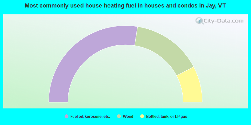
- 55.1%Fuel oil, kerosene, etc.
- 29.7%Wood
- 15.3%Bottled, tank, or LP gas
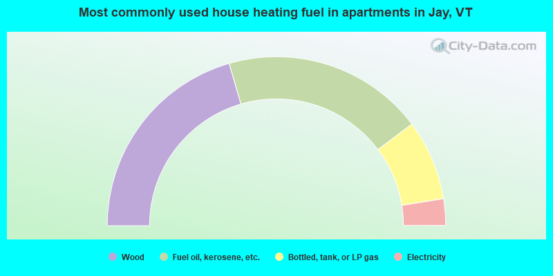
- 41.0%Wood
- 38.5%Fuel oil, kerosene, etc.
- 15.4%Bottled, tank, or LP gas
- 5.1%Electricity
Jay compared to Vermont state average:
- Unemployed percentage below state average.
- Hispanic race population percentage significantly below state average.
- Median age below state average.
- Foreign-born population percentage significantly above state average.
- Length of stay since moving in significantly above state average.
- Number of rooms per house significantly below state average.
- House age significantly below state average.
- Number of college students below state average.
Jay on our top lists:
- #15 on the list of "Top 101 cities with the most residents born in Northern America (population 500+)"
- #15 on the list of "Top 101 cities with the most residents born in Canada (population 500+)"
- #34 (05859) on the list of "Top 101 zip codes with the largest percentage of French Canadian first ancestries"