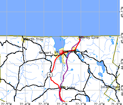
Newport, Vermont
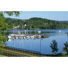
Newport: marina

Newport: Fall at Lake Memphremagog

Newport: "Reflections"-Clyde Pond-newport, VT 10/07

Newport: snow in april

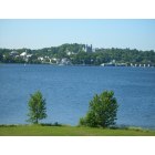
Newport: Lake Memphremagog, from Newport
Newport: Newport photo taken from Prouty Beach
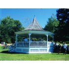
Newport: Band Gazebo in Gardner Park
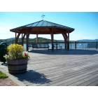
Newport: Public seating - July

Newport: Sunset over Memphremagog

Newport: Bald eagle captured on the bike path in Newport 9/07
- add
your
Submit your own pictures of this city and show them to the world
- OSM Map
- General Map
- Google Map
- MSN Map
Population change since 2000: -12.0%
 |
| Males: 2,235 | |
| Females: 2,168 |
| Median resident age: | 47.2 years |
| Vermont median age: | 43.2 years |
Zip codes: 05855.
| Newport: | $53,010 |
| VT: | $73,991 |
Estimated per capita income in 2022: $32,608 (it was $20,054 in 2000)
Newport city income, earnings, and wages data
Estimated median house or condo value in 2022: $187,809 (it was $79,800 in 2000)
| Newport: | $187,809 |
| VT: | $304,700 |
Mean prices in 2022: all housing units: $227,898; detached houses: $228,061; townhouses or other attached units: $323,018; in 2-unit structures: $117,349; in 3-to-4-unit structures: $275,945; mobile homes: $121,945
Median gross rent in 2022: $856.
(15.4% for White Non-Hispanic residents, 50.0% for Hispanic or Latino residents, 100.0% for American Indian residents)
Detailed information about poverty and poor residents in Newport, VT
Compare current foreclosures near Newport, VT:
| Photo | Address | Area | Beds / Baths | Price | Details |
|---|---|---|---|---|---|

|
#1
Salem Derby Rd
Newport, VT 05855
|
- sq. feet
|
1 baths 3 beds |
$129,900
|
show details |

|
#2
Vt Route 14 N
Newport, VT 05855
|
- sq. feet
|
- baths - beds |
show details | |

|
#3
Mount Vernon St
Newport, VT 05855
|
- sq. feet
|
- baths - beds |
show details | |

|
#4
Pepin Rd
Orleans, VT 05860
|
952 sq. feet
|
1 baths 1 beds |
show details | |

|
#5
Lynwood Dr Apt 6
Derby, VT 05829
|
- sq. feet
|
- baths - beds |
show details | |

|
#6
Vt Route 105
Newport Center, VT 05857
|
- sq. feet
|
- baths - beds |
show details | |

|
#7
Glover Rd
Barton, VT 05822
|
- sq. feet
|
- baths - beds |
show details | |

|
Check over 1 million property listings on Foreclosure.com!
|
browse all offers | |||


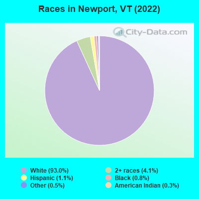
- 4,14093.0%White alone
- 1814.1%Two or more races
- 501.1%Hispanic
- 340.8%Black alone
- 210.5%Other race alone
- 120.3%American Indian alone
- 20.04%Native Hawaiian and Other
Pacific Islander alone
Races in Newport detailed stats: ancestries, foreign born residents, place of birth
According to our research of Vermont and other state lists, there were 21 registered sex offenders living in Newport, Vermont as of April 28, 2024.
The ratio of all residents to sex offenders in Newport is 210 to 1.
Type |
2009 |
2010 |
2011 |
2012 |
2013 |
2014 |
2015 |
2016 |
2017 |
2018 |
2019 |
2020 |
2021 |
2022 |
|---|---|---|---|---|---|---|---|---|---|---|---|---|---|---|
| Murders (per 100,000) | 0 (0.0) | 0 (0.0) | 1 (21.8) | 0 (0.0) | 0 (0.0) | 0 (0.0) | 0 (0.0) | 0 (0.0) | 0 (0.0) | 0 (0.0) | 0 (0.0) | 1 (23.7) | 0 (0.0) | 0 (0.0) |
| Rapes (per 100,000) | 1 (19.4) | 4 (87.2) | 3 (65.3) | 7 (153.0) | 8 (177.3) | 5 (111.0) | 3 (67.5) | 6 (135.9) | 18 (419.9) | 5 (117.7) | 8 (189.8) | 4 (94.7) | 7 (167.4) | 5 (112.8) |
| Robberies (per 100,000) | 2 (38.7) | 1 (21.8) | 0 (0.0) | 0 (0.0) | 1 (22.2) | 0 (0.0) | 0 (0.0) | 0 (0.0) | 0 (0.0) | 1 (23.5) | 0 (0.0) | 2 (47.4) | 1 (23.9) | 3 (67.7) |
| Assaults (per 100,000) | 5 (96.8) | 5 (109.0) | 13 (283.0) | 13 (284.1) | 6 (132.9) | 5 (111.0) | 3 (67.5) | 16 (362.4) | 21 (489.9) | 16 (376.6) | 26 (616.7) | 25 (592.1) | 18 (430.5) | 33 (744.4) |
| Burglaries (per 100,000) | 35 (677.9) | 35 (762.7) | 39 (848.9) | 20 (437.1) | 38 (842.0) | 24 (532.7) | 11 (247.4) | 6 (135.9) | 18 (419.9) | 13 (306.0) | 16 (379.5) | 6 (142.1) | 8 (191.3) | 9 (203.0) |
| Thefts (per 100,000) | 121 (2,344) | 68 (1,482) | 106 (2,307) | 58 (1,267) | 91 (2,016) | 92 (2,042) | 52 (1,169) | 39 (883.4) | 67 (1,563) | 92 (2,166) | 71 (1,684) | 50 (1,184) | 60 (1,435) | 96 (2,166) |
| Auto thefts (per 100,000) | 1 (19.4) | 0 (0.0) | 1 (21.8) | 2 (43.7) | 3 (66.5) | 4 (88.8) | 0 (0.0) | 0 (0.0) | 0 (0.0) | 4 (94.2) | 3 (71.2) | 1 (23.7) | 2 (47.8) | 1 (22.6) |
| Arson (per 100,000) | 0 (0.0) | 0 (0.0) | 2 (43.5) | 1 (21.9) | 0 (0.0) | 0 (0.0) | 0 (0.0) | 1 (22.7) | 0 (0.0) | 1 (23.5) | 0 (0.0) | 1 (23.7) | 0 (0.0) | 0 (0.0) |
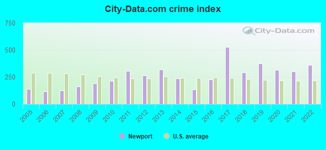
| City-Data.com crime index | 189.2 | 210.7 | 305.8 | 264.0 | 320.0 | 237.1 | 131.5 | 226.0 | 525.8 | 292.1 | 374.8 | 315.0 | 301.8 | 362.1 |
The City-Data.com crime index weighs serious crimes and violent crimes more heavily. Higher means more crime, U.S. average is 246.1. It adjusts for the number of visitors and daily workers commuting into cities.
Crime rate in Newport detailed stats: murders, rapes, robberies, assaults, burglaries, thefts, arson
Full-time law enforcement employees in 2021, including police officers: 16 (12 officers - 11 male; 1 female).
| Officers per 1,000 residents here: | 2.87 |
| Vermont average: | 1.69 |
 Recent articles from our blog. Our writers, many of them Ph.D. graduates or candidates, create easy-to-read articles on a wide variety of topics.

 | Newport VT pollution (2 replies) |
| Newport, VT train traffic (0 replies) |
| Anyone move to VT from NC, or VT to NC? (107 replies) |
| Moving to Newport Vt from NV and wanted a bit more info :) (33 replies) |
| Best city in Vermont (35 replies) |
| Panhandling in Brattleboro (55 replies) |
Latest news from Newport, VT collected exclusively by city-data.com from local newspapers, TV, and radio stations
Ancestries: American (18.2%), English (17.8%), French Canadian (15.0%), German (14.1%), Scandinavian (7.0%), French (5.9%).
Current Local Time: EST time zone
Elevation: 723 feet
Land area: 6.03 square miles.
Population density: 730 people per square mile (low).
88 residents are foreign born
| This city: | 2.0% |
| Vermont: | 4.4% |
Median real estate property taxes paid for housing units with mortgages in 2022: $3,609 (1.9%)
Median real estate property taxes paid for housing units with no mortgage in 2022: $3,357 (1.9%)
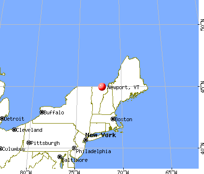
Nearest city with pop. 50,000+: Portland, ME  (130.4 miles , pop. 64,249).
Nearest city with pop. 200,000+: Boston, MA (189.8 miles , pop. 589,141).
Nearest city with pop. 1,000,000+: Bronx, NY (295.7 miles , pop. 1,332,650).
Nearest cities:
), ), ), )Latitude: 44.94 N, Longitude: 72.20 W
Daytime population change due to commuting: +2,747 (+61.7%)
Workers who live and work in this city: 1,198 (65.8%)
Area code: 802
Newport, Vermont accommodation & food services, waste management - Economy and Business Data
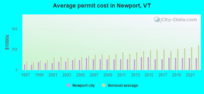
Single-family new house construction building permits:
- 2022: 2 buildings, average cost: $150,000
- 2021: 2 buildings, average cost: $150,000
- 2020: 2 buildings, average cost: $150,000
- 2019: 6 buildings, average cost: $151,700
- 2018: 6 buildings, average cost: $151,700
- 2017: 5 buildings, average cost: $132,000
- 2016: 5 buildings, average cost: $132,000
- 2015: 2 buildings, average cost: $160,000
- 2014: 2 buildings, average cost: $160,000
- 2013: 4 buildings, average cost: $135,300
- 2012: 4 buildings, average cost: $135,300
- 2011: 4 buildings, average cost: $135,300
- 2010: 5 buildings, average cost: $135,300
- 2009: 4 buildings, average cost: $135,300
- 2008: 5 buildings, average cost: $135,300
- 2007: 7 buildings, average cost: $135,300
- 2006: 8 buildings, average cost: $149,400
- 2005: 10 buildings, average cost: $124,300
- 2004: 12 buildings, average cost: $124,300
- 2003: 9 buildings, average cost: $106,200
- 2002: 6 buildings, average cost: $103,300
- 2001: 9 buildings, average cost: $86,800
- 2000: 12 buildings, average cost: $88,500
- 1999: 9 buildings, average cost: $100,000
- 1998: 4 buildings, average cost: $68,800
- 1997: 6 buildings, average cost: $72,700
| Here: | 3.0% |
| Vermont: | 2.0% |
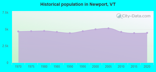
Population change in the 1990s: +531 (+11.9%).
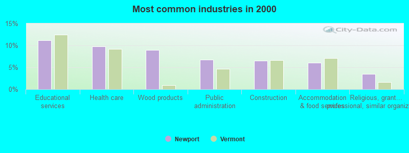
- Educational services (11.2%)
- Health care (9.8%)
- Wood products (8.9%)
- Public administration (6.7%)
- Construction (6.5%)
- Accommodation & food services (6.1%)
- Religious, grantmaking, civic, professional, similar organizations (3.4%)
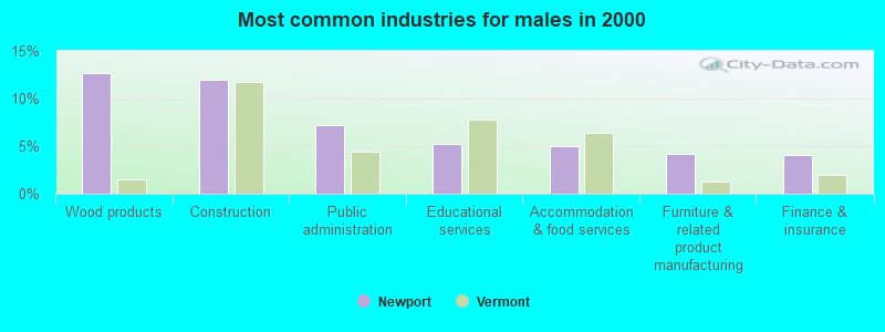
- Wood products (12.6%)
- Construction (12.0%)
- Public administration (7.2%)
- Educational services (5.2%)
- Accommodation & food services (5.0%)
- Furniture & related product manufacturing (4.2%)
- Finance & insurance (4.1%)
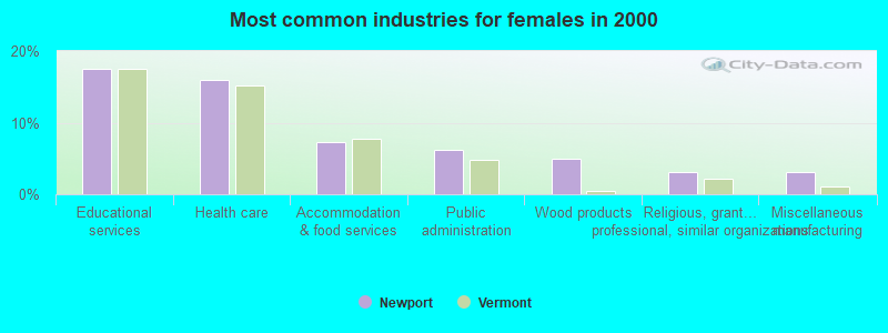
- Educational services (17.5%)
- Health care (16.0%)
- Accommodation & food services (7.3%)
- Public administration (6.1%)
- Wood products (5.0%)
- Religious, grantmaking, civic, professional, similar organizations (3.2%)
- Miscellaneous manufacturing (3.1%)
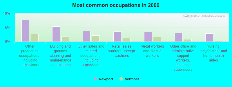
- Other production occupations, including supervisors (7.6%)
- Building and grounds cleaning and maintenance occupations (5.3%)
- Other sales and related occupations, including supervisors (3.8%)
- Retail sales workers, except cashiers (3.7%)
- Metal workers and plastic workers (3.4%)
- Other office and administrative support workers, including supervisors (3.0%)
- Nursing, psychiatric, and home health aides (2.9%)
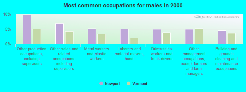
- Other production occupations, including supervisors (9.8%)
- Other sales and related occupations, including supervisors (6.9%)
- Metal workers and plastic workers (5.2%)
- Laborers and material movers, hand (5.1%)
- Driver/sales workers and truck drivers (5.0%)
- Other management occupations, except farmers and farm managers (5.0%)
- Building and grounds cleaning and maintenance occupations (4.5%)
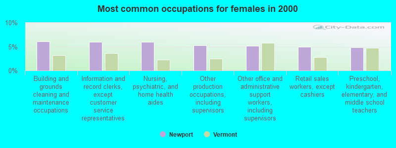
- Building and grounds cleaning and maintenance occupations (6.1%)
- Information and record clerks, except customer service representatives (6.0%)
- Nursing, psychiatric, and home health aides (6.0%)
- Other production occupations, including supervisors (5.2%)
- Other office and administrative support workers, including supervisors (5.1%)
- Retail sales workers, except cashiers (5.0%)
- Preschool, kindergarten, elementary, and middle school teachers (4.9%)
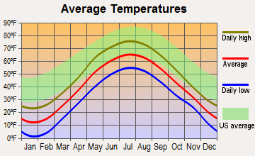
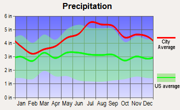
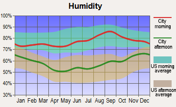
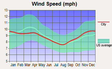
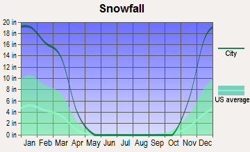
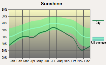
Average climate in Newport, Vermont
Based on data reported by over 4,000 weather stations

|
|

Earthquake activity:
Newport-area historical earthquake activity is significantly above Vermont state average. It is 77% smaller than the overall U.S. average.On 4/20/2002 at 10:50:47, a magnitude 5.3 (5.3 ML, Depth: 3.0 mi, Class: Moderate, Intensity: VI - VII) earthquake occurred 79.2 miles away from Newport center
On 4/20/2002 at 10:50:47, a magnitude 5.2 (5.2 MB, 4.2 MS, 5.2 MW, 5.0 MW) earthquake occurred 80.8 miles away from the city center
On 10/7/1983 at 10:18:46, a magnitude 5.3 (5.1 MB, 5.3 LG, 5.1 ML) earthquake occurred 125.8 miles away from Newport center
On 1/19/1982 at 00:14:42, a magnitude 4.7 (4.5 MB, 4.7 MD, 4.5 LG, Class: Light, Intensity: IV - V) earthquake occurred 104.3 miles away from Newport center
On 10/16/2012 at 23:12:25, a magnitude 4.7 (4.7 ML, Depth: 10.0 mi) earthquake occurred 120.7 miles away from the city center
On 6/16/1995 at 12:13:11, a magnitude 3.8 (3.8 LG, Depth: 3.1 mi, Class: Light, Intensity: II - III) earthquake occurred 47.7 miles away from the city center
Magnitude types: regional Lg-wave magnitude (LG), body-wave magnitude (MB), duration magnitude (MD), local magnitude (ML), surface-wave magnitude (MS), moment magnitude (MW)
Natural disasters:
The number of natural disasters in Orleans County (23) is greater than the US average (15).Major Disasters (Presidential) Declared: 17
Emergencies Declared: 2
Causes of natural disasters: Floods: 16, Storms: 14, Tropical Storms: 2, Winds: 2, Winter Storms: 2, Heavy Rain: 1, Hurricane: 1, Landslide: 1, Snowstorm: 1, Tornado: 1, Other: 1 (Note: some incidents may be assigned to more than one category).
Hospitals and medical centers in Newport:
- NORTH COUNTRY HOSPITAL AND HEALTH CENTER (Voluntary non-profit - Private, 189 PROUTY DRIVE)
- BELAIRE QUALITY CENTER (35 BEL-AIRE DRIVE)
- NEWPORT HEALTH CARE CENTER (148 PROUTY DRIVE)
- FLETCHER ALLEN HEALTHCARE - NORTH COUNTRY DIALYSIS UNIT (189 PROUTY DRIVE)
- ORLEANS ESSEX VNA AND HOSPICE (46 LAKEMONT ROAD)
Airports and heliports located in Newport:
- Newport State Airport (EFK) (Runways: 2, Itinerant Ops: 1,980, Local Ops: 7,234, Military Ops: 238)
- North Country Hospital Heliport (VT70)
Colleges/universities with over 2000 students nearest to Newport:
- Saint Michael's College (about 57 miles; Colchester, VT; Full-time enrollment: 2,336)
- Community College of Vermont (about 58 miles; Winooski, VT; FT enrollment: 3,394)
- University of Vermont (about 59 miles; Burlington, VT; FT enrollment: 11,566)
- Champlain College (about 59 miles; Burlington, VT; FT enrollment: 2,623)
- Norwich University (about 61 miles; Northfield, VT; FT enrollment: 4,221)
- SUNY College at Plattsburgh (about 65 miles; Plattsburgh, NY; FT enrollment: 5,934)
- Middlebury College (about 81 miles; Middlebury, VT; FT enrollment: 3,077)
Public high school in Newport:
- NORTH COUNTRY SENIOR UHSD #22 (Students: 1,038, Location: 209 VETERANS AVENUE, Grades: 9-12)
Private high school in Newport:
Public elementary/middle school in Newport:
- NEWPORT CITY ELEMENTARY SCHOOL (Students: 317, Location: 166 SIAS AVENUE, Grades: PK-6)
User-submitted facts and corrections:
- St. Mary Star of the Sea Roman Catholic Church is the largest church in Newport. Additionally , it sits on the highest point of the city, Prospect Hill
Points of interest:
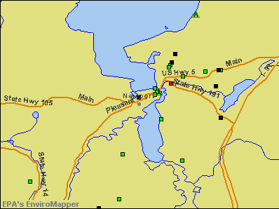
Notable locations in Newport: Goodrich Memorial Library (A), Vermonts North Country Chamber of Commerce (B), Orleans County Jail (C), Orleans County Courthouse (D), North Country Hospital and Health Center Library (E), City of Newport Fire Department (F), Newport Ambulance Services Incorporated (G). Display/hide their locations on the map
Churches in Newport include: Saint Mark Episcopal Church (A), Seventh Day Adventist Church (B), United Church of Newport (C). Display/hide their locations on the map
Cemeteries: Saint Marys Cemetery (1), Pine Grove Cemetery (2), East Main Street Cemetery (3). Display/hide their locations on the map
Rivers: Black River (A), Clyde River (B). Display/hide their locations on the map
Hotels: Inn at the Hill Top of the Hills (1724 East Main Street), Pepin's Motel (Derby Rd).
Court: Vermont State - Courts- Family Court- Orleans (247 Main Street).
Birthplace of: Vivian Vachon - Professional wrestler, Winston L. Prouty - Politician.
Drinking water stations with addresses in Newport and their reported violations in the past:
NEWPORT CITY WATER SYSTEM (Address: 222 MAIN ST , Population served: 4,766, Groundwater):Past health violations:NEWPORT COUNTRY CLUB (Address: 434 PINE HILL RD , Population served: 245, Groundwater):Past monitoring violations:
- MCL, Average - Between JUL-2007 and SEP-2007, Contaminant: Arsenic. Follow-up actions: St Formal NOV issued (NOV-13-2007), St Public Notif requested (NOV-13-2007), St Public Notif received (DEC-10-2007), St Compliance achieved (SEP-27-2010)
- MCL, Average - Between APR-2007 and JUN-2007, Contaminant: Arsenic. Follow-up actions: St Formal NOV issued (SEP-18-2007), St Public Notif requested (SEP-18-2007), St Public Notif received (OCT-26-2007), St Compliance achieved (SEP-27-2010)
- MCL, Average - Between JAN-2007 and MAR-2007, Contaminant: Arsenic. Follow-up actions: St Public Notif requested (JUN-11-2007), St Formal NOV issued (JUN-11-2007), St Compliance achieved (JUN-26-2007), St Public Notif received (JUN-26-2007)
- MCL, Average - Between OCT-2006 and DEC-2006, Contaminant: Arsenic. Follow-up actions: St Formal NOV issued (JAN-12-2007), St Public Notif requested (JAN-12-2007), St Public Notif received (MAR-09-2007), St Compliance achieved (SEP-27-2010)
- MCL, Average - Between JUL-2006 and SEP-2006, Contaminant: Arsenic. Follow-up actions: St Formal NOV issued (OCT-19-2006), St Public Notif requested (OCT-19-2006), St Public Notif received (NOV-02-2006), St Compliance achieved (SEP-27-2010)
- MCL, Average - Between APR-2006 and JUN-2006, Contaminant: Arsenic. Follow-up actions: St Formal NOV issued (AUG-10-2006), St Public Notif requested (AUG-10-2006), St Public Notif received (AUG-23-2006), St Compliance achieved (SEP-27-2010)
- MCL, Average - Between JAN-2006 and MAR-2006, Contaminant: Arsenic. Follow-up actions: St Formal NOV issued (JUN-09-2006), St Public Notif requested (JUN-09-2006), St Compliance achieved (SEP-27-2010)
- Monitoring and Reporting (DBP) - Between JUL-2011 and SEP-2011, Contaminant: Chlorine. Follow-up actions: St Public Notif requested (FEB-02-2012), St Formal NOV issued (FEB-02-2012), St Public Notif received (JUN-22-2012), St Compliance achieved (FEB-11-2013)
- One minor monitoring violation
- One regular monitoring violation
Past monitoring violations:NORTH COUNTRY CAREER CENTER LAND LAB (Address: 209 VETERANS AVENUE , Population served: 80, Groundwater):
- Monitoring, Source Water (GWR) - In JAN-01-2011, Contaminant: E. COLI. Follow-up actions: St Formal NOV issued (FEB-18-2011), St Public Notif requested (FEB-18-2011)
- Monitoring, Repeat Major (TCR) - Between OCT-2010 and DEC-2010, Contaminant: Coliform (TCR). Follow-up actions: St Public Notif requested (JAN-25-2011), St Formal NOV issued (JAN-25-2011), St Compliance achieved (FEB-03-2012)
- 3 routine major monitoring violations
- One minor monitoring violation
Past health violations:DERBY BOYS LLC (Population served: 65, Groundwater):Past monitoring violations:
- MCL, Monthly (TCR) - In AUG-2013, Contaminant: Coliform. Follow-up actions: St Tech Assistance Visit (SEP-04-2013), St Formal NOV issued (SEP-04-2013), St Boil Water Order (SEP-04-2013), St Public Notif requested (SEP-04-2013), St Public Notif received (SEP-05-2013), St Compliance achieved (DEC-23-2013)
- MCL, Monthly (TCR) - In DEC-2009, Contaminant: Coliform. Follow-up actions: St Tech Assistance Visit (JAN-11-2010), St Formal NOV issued (JAN-11-2010), St Public Notif requested (JAN-11-2010), St Boil Water Order (JAN-11-2010), St Compliance achieved (NOV-30-2010)
- MCL, Monthly (TCR) - In AUG-2008, Contaminant: Coliform. Follow-up actions: St Boil Water Order (AUG-20-2008), St Formal NOV issued (AUG-20-2008), St Tech Assistance Visit (AUG-20-2008), St Public Notif requested (AUG-20-2008), St Compliance achieved (FEB-11-2013)
- MCL, Monthly (TCR) - In JUL-2008, Contaminant: Coliform. Follow-up actions: St Public Notif requested (AUG-04-2008), St Formal NOV issued (AUG-04-2008), St Compliance achieved (FEB-11-2013)
- Monitoring, Source Water (GWR) - In AUG-08-2013, Contaminant: E. COLI. Follow-up actions: St Public Notif requested (OCT-14-2013), St Formal NOV issued (OCT-14-2013), St Compliance achieved (FEB-07-2014)
- Monitoring, Repeat Major (TCR) - Between JUL-2013 and SEP-2013, Contaminant: Coliform (TCR). Follow-up actions: St Public Notif requested (NOV-26-2013), St Formal NOV issued (NOV-26-2013), St Compliance achieved (FEB-07-2014)
- Monitoring, Repeat Major (TCR) - Between JUL-2010 and SEP-2010, Contaminant: Coliform (TCR). Follow-up actions: St Public Notif requested (NOV-02-2010), St Formal NOV issued (NOV-02-2010), St Compliance achieved (FEB-11-2013)
- Initial Tap Sampling for Pb and Cu - In JUL-01-2009, Contaminant: Lead and Copper Rule. Follow-up actions: St Formal NOV issued (NOV-05-2009), St Tech Assistance Visit (NOV-05-2009), St Other (NOV-05-2009), St Public Notif requested (NOV-05-2009), St Public Notif received (JAN-14-2010), St Compliance achieved (MAR-09-2010)
- Monitoring, Repeat Major (TCR) - In NOV-2008, Contaminant: Coliform (TCR). Follow-up actions: St Formal NOV issued (JAN-02-2009), St Compliance achieved (FEB-11-2013)
- 3 routine major monitoring violations
- 46 regular monitoring violations
Past health violations:RIDGEVIEW 91 ROASTERS CAFE DELI (Population served: 25, Groundwater):Past monitoring violations:
- OCCT/SOWT Treatment Installation/Demonstration - In JAN-20-2012, Contaminant: Lead and Copper Rule. Follow-up actions: St Formal NOV issued (JAN-20-2012)
- Initial Tap Sampling for Pb and Cu - In JAN-01-2014, Contaminant: Lead and Copper Rule. Follow-up actions: St Formal NOV issued (FEB-14-2014), St Public Notif requested (FEB-14-2014), St Tech Assistance Visit (FEB-14-2014)
- Initial Tap Sampling for Pb and Cu - In JUL-01-2013, Contaminant: Lead and Copper Rule. Follow-up actions: St Formal NOV issued (AUG-01-2013), St Public Notif requested (AUG-01-2013), St Tech Assistance Visit (AUG-01-2013)
- Initial Tap Sampling for Pb and Cu - In JAN-01-2013, Contaminant: Lead and Copper Rule. Follow-up actions: St Formal NOV issued (FEB-25-2013), St Public Notif requested (FEB-25-2013), St Tech Assistance Visit (FEB-25-2013)
- Follow-up Or Routine LCR Tap M/R - In JUL-01-2012, Contaminant: Lead and Copper Rule. Follow-up actions: St Other (OCT-09-2012), St Formal NOV issued (OCT-09-2012), St Public Notif requested (OCT-09-2012), St Tech Assistance Visit (OCT-09-2012)
- Initial Tap Sampling for Pb and Cu - In JAN-01-2012, Contaminant: Lead and Copper Rule. Follow-up actions: St Formal NOV issued (MAR-09-2012), St Public Notif requested (MAR-09-2012), St Tech Assistance Visit (MAR-09-2012)
- 12 routine major monitoring violations
- 58 regular monitoring violations
Past health violations:TANGUAY HOMES (Population served: 25, Groundwater):
- MCL, Monthly (TCR) - In OCT-2013, Contaminant: Coliform. Follow-up actions: St Tech Assistance Visit (OCT-25-2013), St Formal NOV issued (OCT-25-2013), St Public Notif requested (OCT-25-2013), St Public Notif received (OCT-25-2013), St Boil Water Order (OCT-25-2013), St Compliance achieved (NOV-12-2013)
- MCL, Monthly (TCR) - In SEP-2012, Contaminant: Coliform. Follow-up actions: St Tech Assistance Visit (SEP-14-2012), St Formal NOV issued (SEP-14-2012), St Public Notif requested (SEP-14-2012), St Boil Water Order (SEP-14-2012), St Compliance achieved (NOV-26-2012)
Past monitoring violations:
- 2 routine major monitoring violations
| This city: | 2.2 people |
| Vermont: | 2.3 people |
| This city: | 55.7% |
| Whole state: | 62.5% |
| This city: | 9.9% |
| Whole state: | 9.2% |
Likely homosexual households (counted as self-reported same-sex unmarried-partner households)
- Lesbian couples: 0.2% of all households
- Gay men: 0.5% of all households
People in group quarters in Newport in 2010:
- 413 people in state prisons
- 104 people in nursing facilities/skilled-nursing facilities
- 17 people in other noninstitutional facilities
- 6 people in emergency and transitional shelters (with sleeping facilities) for people experiencing homelessness
- 6 people in group homes intended for adults
People in group quarters in Newport in 2000:
- 286 people in state prisons
- 109 people in nursing homes
- 6 people in other group homes
- 6 people in religious group quarters
- 5 people in other noninstitutional group quarters
Banks with branches in Newport (2011 data):
- Community National Bank: Newport Branch at 266 Main Street, branch established on 1985/01/12. Info updated 2010/06/02: Bank assets: $552.1 mil, Deposits: $454.6 mil, headquarters in Derby, VT, positive income, Commercial Lending Specialization, 15 total offices, Holding Company: Community Bancorp
- Passumpsic Savings Bank: Newport Branch at 1 Gardner Street, branch established on 1981/03/23. Info updated 2008/07/16: Bank assets: $571.1 mil, Deposits: $460.4 mil, headquarters in St. Johnsbury, VT, negative income in the last year, Commercial Lending Specialization, 13 total offices, Holding Company: Passumpsic Bancorp
- People's United Bank: Newport Branch at 15 Main Street, branch established on 1954/10/11. Info updated 2012/02/16: Bank assets: $27,319.3 mil, Deposits: $20,835.4 mil, headquarters in Bridgeport, CT, positive income, Commercial Lending Specialization, 374 total offices
For population 15 years and over in Newport:
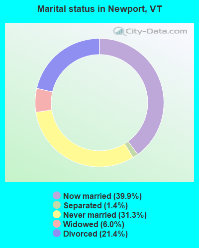
- Never married: 31.3%
- Now married: 39.9%
- Separated: 1.4%
- Widowed: 6.0%
- Divorced: 21.4%
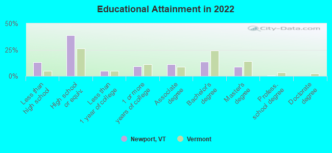
For population 25 years and over in Newport:
- High school or higher: 86.1%
- Bachelor's degree or higher: 21.5%
- Graduate or professional degree: 8.2%
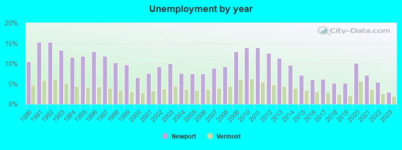
- Unemployed: 9.2%
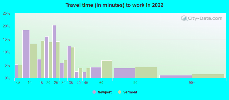
- Mean travel time to work (commute): 18.5 minutes
| Here: | 12.0 |
| Vermont average: | 10.8 |
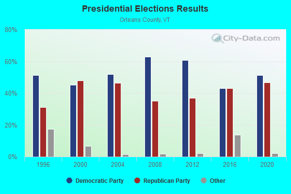
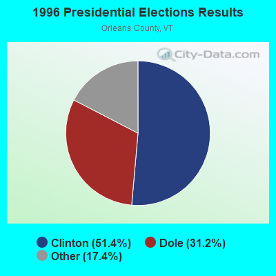
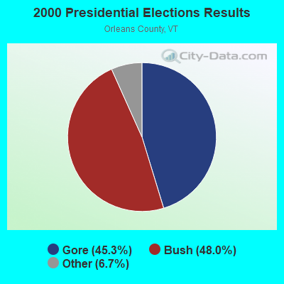
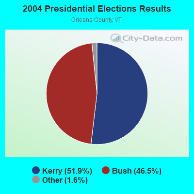
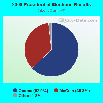
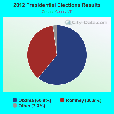


Graphs represent county-level data. Detailed 2008 Election Results
Religion statistics for Newport, VT (based on Orleans County data)
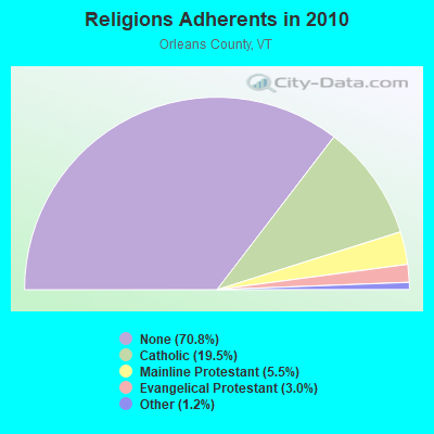
| Religion | Adherents | Congregations |
|---|---|---|
| Catholic | 5,312 | 12 |
| Mainline Protestant | 1,485 | 23 |
| Evangelical Protestant | 822 | 14 |
| Other | 323 | 4 |
| None | 19,289 | - |
Food Environment Statistics:
| Orleans County: | 5.14 / 10,000 pop. |
| Vermont: | 3.84 / 10,000 pop. |
| Here: | 1.10 / 10,000 pop. |
| Vermont: | 1.95 / 10,000 pop. |
| This county: | 6.60 / 10,000 pop. |
| Vermont: | 6.40 / 10,000 pop. |
| This county: | 8.07 / 10,000 pop. |
| Vermont: | 11.52 / 10,000 pop. |
| Orleans County: | 7.0% |
| Vermont: | 6.8% |
| This county: | 24.8% |
| Vermont: | 22.3% |
| Orleans County: | 10.8% |
| Vermont: | 13.3% |
Health and Nutrition:
| Newport: | 49.9% |
| State: | 52.9% |
| Newport: | 46.5% |
| Vermont: | 51.9% |
| Newport: | 29.4 |
| State: | 28.4 |
| This city: | 23.0% |
| Vermont: | 21.2% |
| This city: | 13.3% |
| Vermont: | 8.8% |
| This city: | 6.8 |
| Vermont: | 6.9 |
| This city: | 37.8% |
| Vermont: | 34.9% |
| Newport: | 55.5% |
| Vermont: | 59.7% |
| Newport: | 76.3% |
| State: | 79.6% |
More about Health and Nutrition of Newport, VT Residents
| Local government employment and payroll (March 2022) | |||||
| Function | Full-time employees | Monthly full-time payroll | Average yearly full-time wage | Part-time employees | Monthly part-time payroll |
|---|---|---|---|---|---|
| Police Protection - Officers | 13 | $61,951 | $57,186 | 3 | $8,682 |
| Streets and Highways | 10 | $46,221 | $55,465 | 0 | $0 |
| Police - Other | 4 | $15,721 | $47,163 | 4 | $2,400 |
| Water Supply | 4 | $18,410 | $55,230 | 0 | $0 |
| Financial Administration | 3 | $14,588 | $58,352 | 0 | $0 |
| Sewerage | 3 | $12,812 | $51,248 | 0 | $0 |
| Other Government Administration | 2 | $11,532 | $69,192 | 6 | $887 |
| Firefighters | 1 | $4,088 | $49,056 | 24 | $2,484 |
| Parks and Recreation | 1 | $4,685 | $56,220 | 1 | $1,701 |
| Other and Unallocable | 1 | $3,959 | $47,508 | 0 | $0 |
| Solid Waste Management | 0 | $0 | 2 | $895 | |
| Totals for Government | 42 | $193,967 | $55,419 | 40 | $17,049 |
Newport government finances - Expenditure in 2021 (per resident):
- Construction - Regular Highways: $292,000 ($66.32)
Water Utilities: $97,000 ($22.03)
Sewerage: $38,000 ($8.63)
- Current Operations - Police Protection: $1,748,000 ($397.00)
Sewerage: $1,700,000 ($386.10)
Regular Highways: $1,373,000 ($311.83)
Water Utilities: $802,000 ($182.15)
General - Other: $699,000 ($158.76)
Parks and Recreation: $686,000 ($155.80)
Central Staff Services: $416,000 ($94.48)
Local Fire Protection: $343,000 ($77.90)
General Public Buildings: $124,000 ($28.16)
Financial Administration: $120,000 ($27.25)
Libraries: $110,000 ($24.98)
Solid Waste Management: $15,000 ($3.41)
- General - Interest on Debt: $37,000 ($8.40)
- Other Capital Outlay - Regular Highways: $117,000 ($26.57)
Police Protection: $90,000 ($20.44)
Local Fire Protection: $52,000 ($11.81)
Parks and Recreation: $9,000 ($2.04)
- Total Salaries and Wages: $1,883,000 ($427.66)
- Water Utilities - Interest on Debt: $151,000 ($34.29)
Newport government finances - Revenue in 2021 (per resident):
- Charges - Sewerage: $1,321,000 ($300.02)
- Local Intergovernmental - General Local Government Support: $491,000 ($111.51)
- Miscellaneous - General Revenue - Other: $1,235,000 ($280.49)
Interest Earnings: $37,000 ($8.40)
Sale of Property: $20,000 ($4.54)
Fines and Forfeits: $10,000 ($2.27)
- Revenue - Water Utilities: $837,000 ($190.10)
- State Intergovernmental - General Local Government Support: $204,000 ($46.33)
Highways: $181,000 ($41.11)
- Tax - Property: $9,013,000 ($2047.01)
Alcoholic Beverage License: $3,000 ($0.68)
Other License: $1,000 ($0.23)
Newport government finances - Debt in 2021 (per resident):
- Long Term Debt - Beginning Outstanding - Unspecified Public Purpose: $4,701,000 ($1067.68)
Outstanding Unspecified Public Purpose: $3,984,000 ($904.84)
Retired Unspecified Public Purpose: $752,000 ($170.79)
Issue, Unspecified Public Purpose: $35,000 ($7.95)
Newport government finances - Cash and Securities in 2021 (per resident):
- Other Funds - Cash and Securities: $817,000 ($185.56)
| Businesses in Newport, VT | ||||
| Name | Count | Name | Count | |
|---|---|---|---|---|
| AT&T | 1 | Rite Aid | 1 | |
| Advance Auto Parts | 1 | Subway | 1 | |
| Ford | 1 | The Room Place | 1 | |
| H&R Block | 1 | U-Haul | 2 | |
| Lane Furniture | 1 | UPS | 1 | |
| RadioShack | 1 | Wendy's | 1 | |
Strongest AM radio stations in Newport:
- WIKE (1490 AM; 1 kW; NEWPORT, VT; Owner: NORTHSTAR MEDIA, INC.)
- WCHP (760 AM; 35 kW; CHAMPLAIN, NY; Owner: CHAMPLAIN RADIO, INC.)
- WICY (1490 AM; 50 kW; MALONE, NY; Owner: CARTIER COMMUNICATIONS INC.)
- WDEV (550 AM; 5 kW; WATERBURY, VT; Owner: RADIO VERMONT, INC.)
- WVMT (620 AM; 5 kW; BURLINGTON, VT; Owner: SISON BROADCASTING, INC.)
- WRKO (680 AM; 50 kW; BOSTON, MA; Owner: ENTERCOM BOSTON LICENSE, LLC)
- WGY (810 AM; 50 kW; SCHENECTADY, NY; Owner: CLEAR CHANNEL BROADCASTING LICENSES, INC.)
- WNNZ (640 AM; 50 kW; WESTFIELD, MA; Owner: CLEAR CHANNEL BROADCASTING LICENSES, INC.)
- WCRN (830 AM; 50 kW; WORCESTER, MA; Owner: CARTER BROADCASTING CORPORATION)
- WTME (780 AM; 10 kW; RUMFORD, ME; Owner: MOUNTAIN VALLEY BROADCASTING, INC.)
- WEEI (850 AM; 50 kW; BOSTON, MA; Owner: ENTERCOM BOSTON LICENSE, LLC)
- WTWN (1100 AM; daytime; 5 kW; WELLS RIVER, VT; Owner: PUFFER BROADCASTING, INC.)
- WBZ (1030 AM; 50 kW; BOSTON, MA; Owner: INFINITY BROADCASTING OPERATIONS, INC.)
Strongest FM radio stations in Newport:
- WMOO (92.1 FM; DERBY CENTER, VT; Owner: NORTHSTAR MEDIA, INC.)
- W243AE (96.5 FM; ORLEANS, VT; Owner: CHRISTIAN MINISTRIES, INC.)
- WLKC (103.3 FM; WATERBURY, VT; Owner: RADIO BROADCASTING SERVICES, INC.)
- WEZF (92.9 FM; BURLINGTON, VT; Owner: CAPSTAR TX LIMITED PARTNERSHIP)
- WVPS (107.9 FM; BURLINGTON, VT; Owner: VERMONT PUBLIC RADIO)
- WGMT (97.7 FM; LYNDON, VT; Owner: VERMONT BROADCAST ASSOCIATES, INC.)
- WCVT (101.7 FM; STOWE, VT; Owner: RADIO VERMONT CLASSICS, L.L.C.)
- WPKQ (103.7 FM; NORTH CONWAY, NH; Owner: CITADEL BROADCASTING COMPANY)
- WHOM (94.9 FM; MT. WASHINGTON, NH; Owner: CITADEL BROADCASTING COMPANY)
- WNCS (104.7 FM; MONTPELIER, VT; Owner: MONTPELIER BROADCASTING, INC.)
- WDOT (95.7 FM; DANVILLE, VT; Owner: MONTPELIER BROADCASTING INC)
- WDEV-FM (96.1 FM; WARREN, VT; Owner: RADIO VERMONT, INC.)
- WMTK (106.3 FM; LITTLETON, NH; Owner: VERMONT BROADCAST ASSOCIATES, INC.)
TV broadcast stations around Newport:
- W14CK (Channel 14; NEWPORT, VT; Owner: SMC COMMUNICATIONS, INC.)
- National Bridge Inventory (NBI) Statistics
- 10Number of bridges
- 112ft / 33.7mTotal length
- $4,618,000Total costs
- 28,155Total average daily traffic
- 1,738Total average daily truck traffic
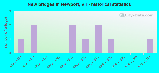
- New bridges - historical statistics
- 11910-1919
- 21920-1929
- 21950-1959
- 11960-1969
- 21970-1979
- 11980-1989
- 12010-2019
FCC Registered Antenna Towers:
21 (See the full list of FCC Registered Antenna Towers in Newport)FCC Registered Broadcast Land Mobile Towers:
15 (See the full list of FCC Registered Broadcast Land Mobile Towers in Newport, VT)FCC Registered Microwave Towers:
3- COVENTRY, 3647 Pine Hill Road (Lat: 44.880972 Lon: -72.173250), Type: Tower, Structure height: 30.5 m, Overall height: 32.6 m, Call Sign: WQIM442,
Assigned Frequencies: 10628.1 MHz, Grant Date: 03/18/2008, Expiration Date: 03/18/2018, Cancellation Date: 02/20/2014, Certifier: Pamelia Y Hoof, Registrant: Verizon Wireless, 1120 Sanctuary Pkwy, #150 Gasa5reg, Alpharetta, GA 30009-7630, Phone: (770) 797-1070, Fax: (770) 797-1036, Email:
- Newport-01, 310 Mtn. View Drive (Lat: 44.931722 Lon: -72.241306), Type: Tank, Structure height: 26.5 m, Call Sign: WQUX638,
Assigned Frequencies: 11225.0 MHz, 11265.0 MHz, 11225.0 MHz, 11265.0 MHz, 11225.0 MHz, 11265.0 MHz, 11225.0 MHz, 11265.0 MHz, 11225.0 MHz, 11265.0 MHz... (+14 more), Grant Date: 11/10/2014, Expiration Date: 11/10/2024, Certifier: Fran Stocker, Registrant: Radyn, Inc, Silver Spring, MD 20914, Phone: (301) 493-5171, Fax: (301) 576-4553, Email:
- COVENTRY, 3647 Pine Hill Road (Lat: 44.880972 Lon: -72.173250), Type: Gtower, Structure height: 30.4 m, Overall height: 32.6 m, Call Sign: WQUZ418,
Assigned Frequencies: 5974.85 MHz, Grant Date: 11/25/2014, Expiration Date: 11/25/2024, Cancellation Date: 08/17/2015, Certifier: Steven A Regitz, Registrant: Verizon Wireless, 1120 Sanctuary Pkwy, #150 Gasa5reg, Alpharetta, GA 30009-7630, Phone: (770) 797-1070, Fax: (770) 797-1036, Email:
FCC Registered Maritime Coast & Aviation Ground Towers:
1- Newport State Airport (Lat: 44.952778 Lon: -72.177778), Type: Tower, Call Sign: WRLB2585,
Assigned Frequencies: 0.24251 MHz, Grant Date: 01/10/2006, Expiration Date: 12/13/2015, Cancellation Date: 06/18/2016, Registrant: Vermont Agency Of Transportation, One National Life Drive, Montpelier, VT 05633-5001, Phone: (802) 828-1083, Fax: (802) 828-2848, Email:
FCC Registered Amateur Radio Licenses:
39 (See the full list of FCC Registered Amateur Radio Licenses in Newport)FAA Registered Aircraft Manufacturers and Dealers:
1 (See the full list of FAA Registered Manufacturers and Dealers in Newport)FAA Registered Aircraft:
11 (See the full list of FAA Registered Aircraft)2002 - 2018 National Fire Incident Reporting System (NFIRS) incidents
- Fire incident types reported to NFIRS in Newport, VT
- 20869.8%Structure Fires
- 4715.8%Outside Fires
- 289.4%Mobile Property/Vehicle Fires
- 155.0%Other
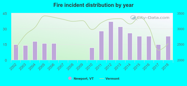 Based on the data from the years 2002 - 2018 the average number of fires per year is 18. The highest number of reported fire incidents - 37 took place in 2012, and the least - 0 in 2007. The data has a growing trend.
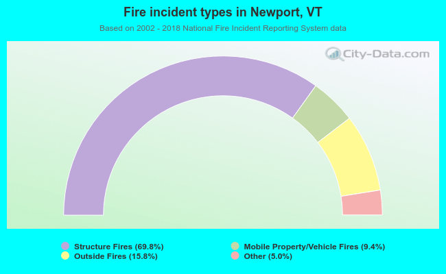 When looking into fire subcategories, the most incidents belonged to: Structure Fires (69.8%), and Outside Fires (15.8%).
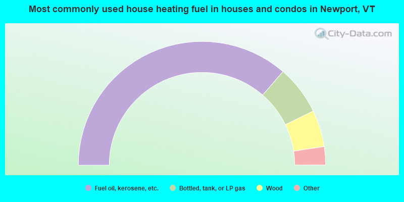
- 72.8%Fuel oil, kerosene, etc.
- 12.9%Bottled, tank, or LP gas
- 9.6%Wood
- 2.9%Other fuel
- 1.1%Utility gas
- 0.7%Electricity
- 70.4%Fuel oil, kerosene, etc.
- 14.4%Bottled, tank, or LP gas
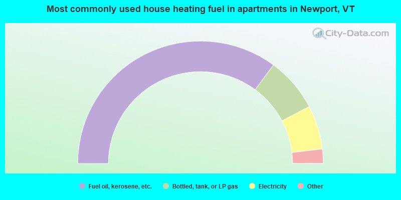
- 11.6%Electricity
- 2.0%Other fuel
- 1.5%Utility gas
Newport compared to Vermont state average:
- Median house value below state average.
- Hispanic race population percentage below state average.
- Median age below state average.
- Foreign-born population percentage significantly below state average.
- Renting percentage above state average.
- Length of stay since moving in above state average.
- Institutionalized population percentage significantly above state average.
- Number of college students below state average.
Newport on our top lists:
- #71 on the list of "Top 101 cities with the most residents born in Northern America (population 500+)"
- #71 on the list of "Top 101 cities with the most residents born in Canada (population 500+)"
- #80 (05855) on the list of "Top 101 zip codes with the largest percentage of French Canadian first ancestries"

|
Total of 2 patent applications in 2008-2024.