Derby, Vermont
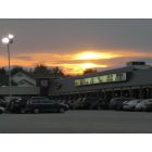
Submit your own pictures of this town and show them to the world
- OSM Map
- Google Map
- MSN Map
Population change since 2000: +0.4%
 |
| Males: 2,234 | |
| Females: 2,387 |
| Median resident age: | 45.0 years |
| Vermont median age: | 45.8 years |
Zip codes: 05829.
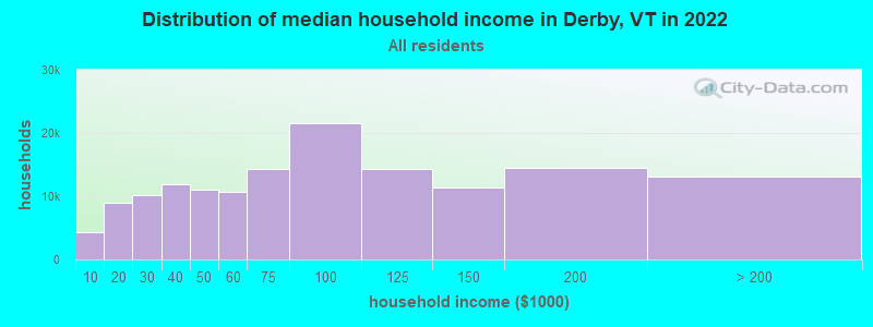
| Derby: | $72,663 |
| VT: | $73,991 |
Estimated per capita income in 2022: $36,257 (it was $17,192 in 2000)
Derby town income, earnings, and wages data
Estimated median house or condo value in 2022: $232,040 (it was $86,900 in 2000)
| Derby: | $232,040 |
| VT: | $304,700 |
Mean prices in 2022: all housing units: $271,502; detached houses: $290,446; townhouses or other attached units: $299,602; in 2-unit structures: $159,589; in 3-to-4-unit structures: $395,771; in 5-or-more-unit structures: $253,965; mobile homes: $74,912
Detailed information about poverty and poor residents in Derby, VT


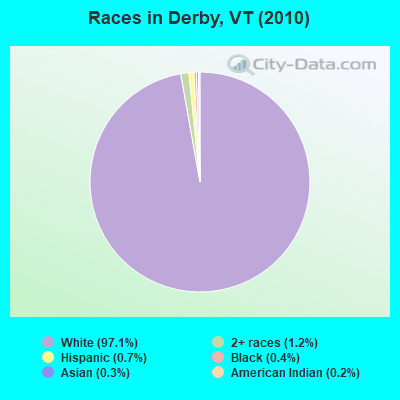
- 4,48697.1%White alone
- 571.2%Two or more races
- 340.7%Hispanic
- 190.4%Black alone
- 140.3%Asian alone
- 100.2%American Indian alone
- 10.02%Native Hawaiian and Other
Pacific Islander alone
Races in Derby detailed stats: ancestries, foreign born residents, place of birth
According to our research of Vermont and other state lists, there were 5 registered sex offenders living in Derby, Vermont as of April 26, 2024.
The ratio of all residents to sex offenders in Derby is 924 to 1.
The ratio of registered sex offenders to all residents in this city is lower than the state average.
 Recent articles from our blog. Our writers, many of them Ph.D. graduates or candidates, create easy-to-read articles on a wide variety of topics.
Ancestries: French Canadian (18.6%), English (17.1%), United States (13.4%), French (12.0%), Irish (11.4%), German (5.7%).
Current Local Time: EST time zone
Land area: 49.6 square miles.
Population density: 93 people per square mile (very low).
298 residents are foreign born (5.7% North America).
| This town: | 6.5% |
| Vermont: | 3.8% |
| Derby town: | 1.5% ($1,300) |
| Vermont: | 2.0% ($2,196) |
Nearest city with pop. 50,000+: Portland, ME  (128.8 miles , pop. 64,249).
Nearest city with pop. 200,000+: Boston, MA (190.1 miles , pop. 589,141).
Nearest city with pop. 1,000,000+: Bronx, NY (298.1 miles , pop. 1,332,650).
Nearest cities:
), ), ), ), )Latitude: 44.96 N, Longitude: 72.13 W
Area code: 802
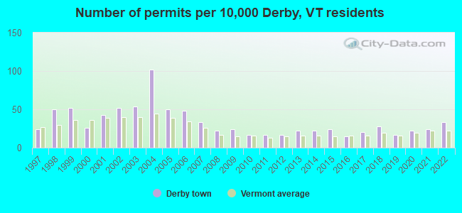
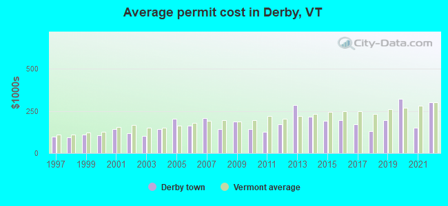
Single-family new house construction building permits:
- 2022: 15 buildings, average cost: $302,800
- 2021: 11 buildings, average cost: $151,800
- 2020: 10 buildings, average cost: $321,000
- 2019: 8 buildings, average cost: $195,000
- 2018: 13 buildings, average cost: $130,500
- 2017: 9 buildings, average cost: $169,600
- 2016: 7 buildings, average cost: $195,700
- 2015: 11 buildings, average cost: $192,200
- 2014: 10 buildings, average cost: $215,600
- 2013: 10 buildings, average cost: $284,500
- 2012: 8 buildings, average cost: $173,100
- 2011: 8 buildings, average cost: $127,600
- 2010: 8 buildings, average cost: $142,500
- 2009: 11 buildings, average cost: $186,100
- 2008: 10 buildings, average cost: $143,600
- 2007: 15 buildings, average cost: $209,700
- 2006: 22 buildings, average cost: $163,800
- 2005: 23 buildings, average cost: $204,500
- 2004: 47 buildings, average cost: $140,800
- 2003: 25 buildings, average cost: $103,800
- 2002: 24 buildings, average cost: $119,200
- 2001: 20 buildings, average cost: $142,200
- 2000: 12 buildings, average cost: $107,800
- 1999: 24 buildings, average cost: $109,700
- 1998: 23 buildings, average cost: $93,000
- 1997: 11 buildings, average cost: $97,100
| Here: | 3.7% |
| Vermont: | 2.0% |
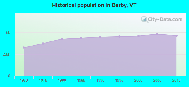
Population change in the 1990s: +92 (+2.0%).
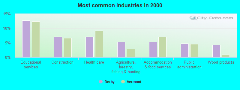
- Educational services (12.7%)
- Construction (7.2%)
- Health care (7.2%)
- Agriculture, forestry, fishing & hunting (5.3%)
- Accommodation & food services (5.3%)
- Public administration (4.8%)
- Wood products (4.3%)
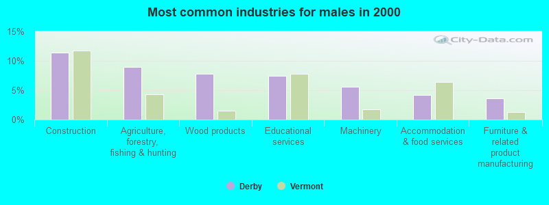
- Construction (11.4%)
- Agriculture, forestry, fishing & hunting (9.0%)
- Wood products (7.8%)
- Educational services (7.4%)
- Machinery (5.6%)
- Accommodation & food services (4.2%)
- Furniture & related product manufacturing (3.6%)
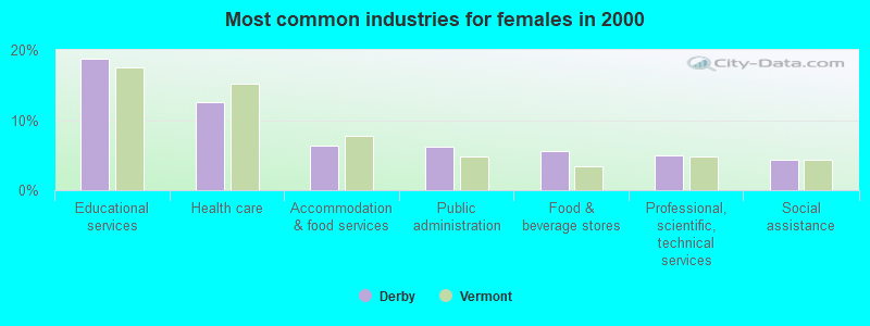
- Educational services (18.7%)
- Health care (12.6%)
- Accommodation & food services (6.4%)
- Public administration (6.1%)
- Food & beverage stores (5.6%)
- Professional, scientific, technical services (5.0%)
- Social assistance (4.4%)
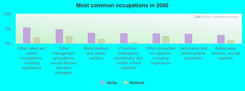
- Other sales and related occupations, including supervisors (5.6%)
- Other management occupations, except farmers and farm managers (5.0%)
- Metal workers and plastic workers (3.7%)
- Preschool, kindergarten, elementary, and middle school teachers (3.6%)
- Other production occupations, including supervisors (3.5%)
- Secretaries and administrative assistants (3.4%)
- Retail sales workers, except cashiers (3.0%)
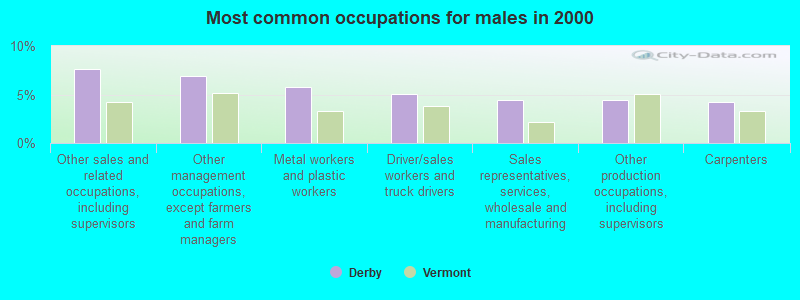
- Other sales and related occupations, including supervisors (7.6%)
- Other management occupations, except farmers and farm managers (6.9%)
- Metal workers and plastic workers (5.8%)
- Driver/sales workers and truck drivers (5.1%)
- Sales representatives, services, wholesale and manufacturing (4.4%)
- Other production occupations, including supervisors (4.4%)
- Carpenters (4.2%)
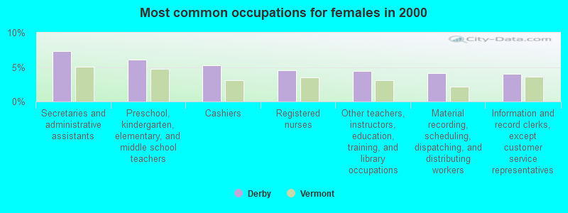
- Secretaries and administrative assistants (7.3%)
- Preschool, kindergarten, elementary, and middle school teachers (6.0%)
- Cashiers (5.3%)
- Registered nurses (4.6%)
- Other teachers, instructors, education, training, and library occupations (4.4%)
- Material recording, scheduling, dispatching, and distributing workers (4.1%)
- Information and record clerks, except customer service representatives (4.0%)
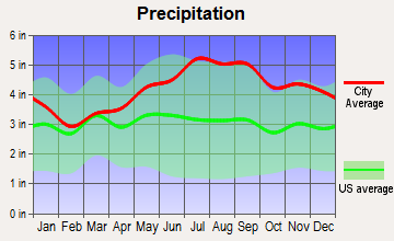
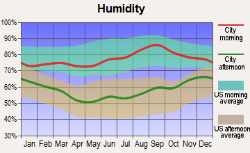
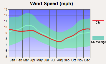
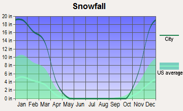
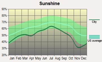
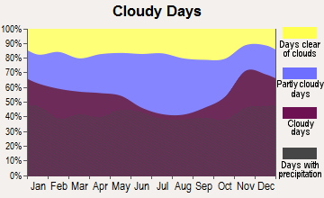
Average climate in Derby, Vermont
Based on data reported by over 4,000 weather stations

Earthquake activity:
Derby-area historical earthquake activity is significantly above Vermont state average. It is 77% smaller than the overall U.S. average.On 4/20/2002 at 10:50:47, a magnitude 5.3 (5.3 ML, Depth: 3.0 mi, Class: Moderate, Intensity: VI - VII) earthquake occurred 82.9 miles away from the city center
On 4/20/2002 at 10:50:47, a magnitude 5.2 (5.2 MB, 4.2 MS, 5.2 MW, 5.0 MW) earthquake occurred 84.6 miles away from Derby center
On 10/7/1983 at 10:18:46, a magnitude 5.3 (5.1 MB, 5.3 LG, 5.1 ML) earthquake occurred 129.5 miles away from the city center
On 1/19/1982 at 00:14:42, a magnitude 4.7 (4.5 MB, 4.7 MD, 4.5 LG, Class: Light, Intensity: IV - V) earthquake occurred 104.7 miles away from Derby center
On 10/16/2012 at 23:12:25, a magnitude 4.7 (4.7 ML, Depth: 10.0 mi) earthquake occurred 119.5 miles away from the city center
On 6/16/1995 at 12:13:11, a magnitude 3.8 (3.8 LG, Depth: 3.1 mi, Class: Light, Intensity: II - III) earthquake occurred 48.1 miles away from the city center
Magnitude types: regional Lg-wave magnitude (LG), body-wave magnitude (MB), duration magnitude (MD), local magnitude (ML), surface-wave magnitude (MS), moment magnitude (MW)
Natural disasters:
The number of natural disasters in Orleans County (23) is greater than the US average (15).Major Disasters (Presidential) Declared: 17
Emergencies Declared: 2
Causes of natural disasters: Floods: 16, Storms: 14, Tropical Storms: 2, Winds: 2, Winter Storms: 2, Heavy Rain: 1, Hurricane: 1, Landslide: 1, Snowstorm: 1, Tornado: 1, Other: 1 (Note: some incidents may be assigned to more than one category).
Main business address for: COMMUNITY BANCORP /VT (NATIONAL COMMERCIAL BANKS).
Hospitals and medical centers in Derby:
Other hospitals and medical centers near Derby:
- NEWPORT HEALTH CARE CENTER (Nursing Home, about 4 miles away; NEWPORT, VT)
- ORLEANS ESSEX VNA AND HOSPICE (Home Health Center, about 4 miles away; NEWPORT, VT)
- FLETCHER ALLEN HEALTHCARE - NORTH COUNTRY DIALYSIS UNIT (Dialysis Facility, about 4 miles away; NEWPORT, VT)
- NORTH COUNTRY HOSPITAL AND HEALTH CENTER Critical Access Hospitals (about 4 miles away; NEWPORT, VT)
Colleges/universities with over 2000 students nearest to Derby:
- Saint Michael's College (about 61 miles; Colchester, VT; Full-time enrollment: 2,336)
- Community College of Vermont (about 61 miles; Winooski, VT; FT enrollment: 3,394)
- University of Vermont (about 63 miles; Burlington, VT; FT enrollment: 11,566)
- Champlain College (about 63 miles; Burlington, VT; FT enrollment: 2,623)
- Norwich University (about 63 miles; Northfield, VT; FT enrollment: 4,221)
- SUNY College at Plattsburgh (about 69 miles; Plattsburgh, NY; FT enrollment: 5,934)
- Middlebury College (about 84 miles; Middlebury, VT; FT enrollment: 3,077)
Public elementary/middle school in Derby:
- NORTH COUNTRY JUNIOR UHSD #22 (Students: 314, Location: 57 JUNIOR HIGH DRIVE, Grades: 7-8)
Libraries in Derby:
- DAILEY MEMORIAL (Operating income: $61,955; Location: 101 JUNIOR HIGH DR.; 12,334 books; 249 audio materials; 700 video materials; 2 local licensed databases; 19 state licensed databases; 24 print serial subscriptions)
- BIG READ WAGON (NCLC) (Operating income: $13,965; Location: 101 JUNIOR HIGH DR.; 5,724 books; 215 audio materials; 236 video materials; 3 local licensed databases; 38 state licensed databases; 161 print serial subscriptions)
Points of interest:
Notable locations in Derby: Meadow Brook Girl Scout Camp (A), Chargo Campground (B), Holland Historical Society Museum (C), Haskell Opera House (D), Haskell Free Library (E), Dailey Memorial Library (F), Vermont Welcome Center (G), Derby Line Fire Department (H), Derby Line Ambulance Incorporated (I). Display/hide their locations on the map
Main business address in Derby: COMMUNITY BANCORP /VT (A). Display/hide its location on the map
Church in Derby: Universalist Church (A). Display/hide its location on the map
Cemeteries: Crandall Cemetery (1), Darby Center Cemetery (2), Tice-Marston Cemetery (3), Morrill-Darling Hill Cemetery (4), Mitchell-Derusha Cemetery (5), Fortin Cemetery (6), Derby Line Cemetery (7). Display/hide their locations on the map
Lakes: Lake Derby (A), Cobb Pond (B), Clyde Pond (C), Lake Salem (D), Lake Memphremagog (E). Display/hide their locations on the map
Streams, rivers, and creeks: Orcutt Brook (A), Johns River (B), Crystal Brook (C), Coche Brook (D), Greens Brook (E). Display/hide their locations on the map
Beach: Balm of Gilead Beach (A). Display/hide its location on the map
Hotel: Border Motel (135 Main St) (1). Display/hide its approximate location on the map
Birthplace of: Charles Kendall Adams - Educator and historian, William Tyler (bishop) - Catholic bishop, John Thornton (Canadian politician) - Politician.
Drinking water stations with addresses in Derby and their reported violations in the past:
CHAR BO CAMPGROUND (Population served: 176, Groundwater):Past health violations:PAULS SUGAR HOUSE (Address: 1928 US RTE 5 , Population served: 50, Groundwater):Past monitoring violations:
- MCL, Monthly (TCR) - Between JUL-2005 and SEP-2005, Contaminant: Coliform. Follow-up actions: St Tech Assistance Visit (OCT-10-2005), St Boil Water Order (OCT-10-2005), St Formal NOV issued (OCT-10-2005), St Public Notif requested (OCT-10-2005), St Public Notif received (OCT-24-2005), St Compliance achieved (JUN-23-2006)
- One routine major monitoring violation
- One minor monitoring violation
- One regular monitoring violation
Past monitoring violations:
- 8 routine major monitoring violations
- One regular monitoring violation
| This town: | 2.3 people |
| Vermont: | 2.3 people |
| This town: | 65.9% |
| Whole state: | 62.5% |
| This town: | 9.2% |
| Whole state: | 9.2% |
Likely homosexual households (counted as self-reported same-sex unmarried-partner households)
- Lesbian couples: 0.5% of all households
- Gay men: 0.3% of all households
| This town: | 10.2% |
| Whole state: | 9.4% |
| This town: | 3.5% |
| Whole state: | 3.6% |
23 people in nursing homes in 2000
Banks with branches in Derby (2011 data):
- Community National Bank: at 4811 U.S. Route 5, branch established on 1851/01/15. Info updated 2010/06/02: Bank assets: $552.1 mil, Deposits: $454.6 mil, local headquarters, positive income, Commercial Lending Specialization, 15 total offices, Holding Company: Community Bancorp
For population 15 years and over in Derby:
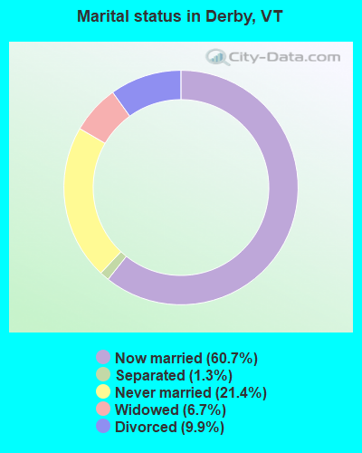
- Never married: 21.4%
- Now married: 60.7%
- Separated: 1.3%
- Widowed: 6.7%
- Divorced: 9.9%
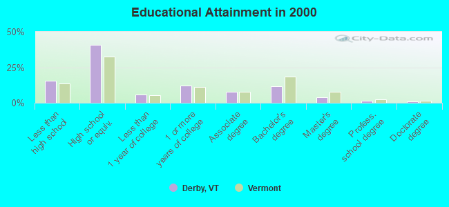
For population 25 years and over in Derby:
- High school or higher: 84.4%
- Bachelor's degree or higher: 17.9%
- Graduate or professional degree: 6.2%
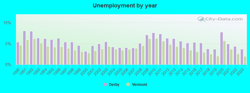
- Unemployed: 5.1%
- Mean travel time to work (commute): 18.7 minutes
| Here: | 11.3 |
| Vermont average: | 11.7 |
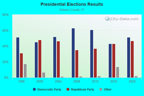
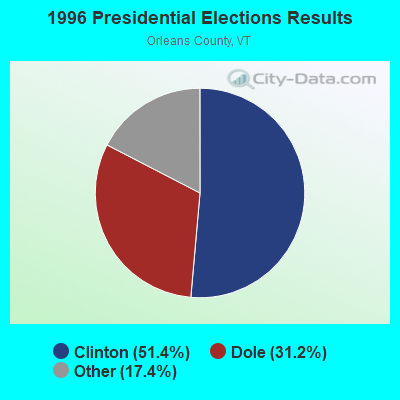
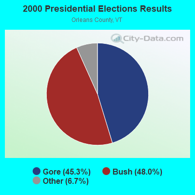
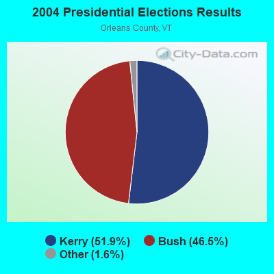
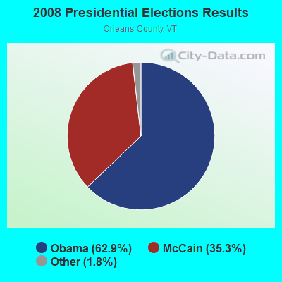
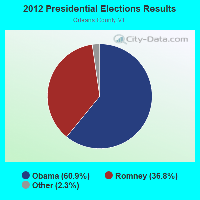
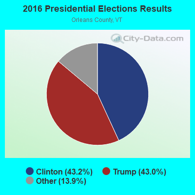
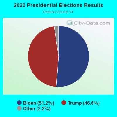
Graphs represent county-level data. Detailed 2008 Election Results
Religion statistics for Derby, VT (based on Orleans County data)
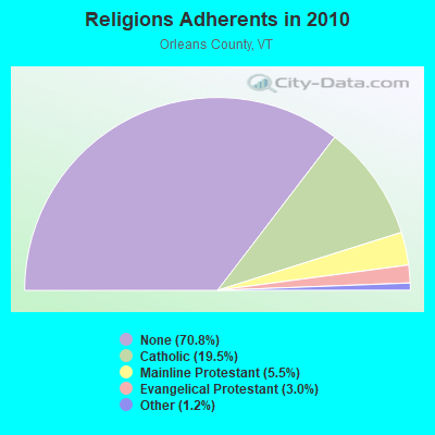
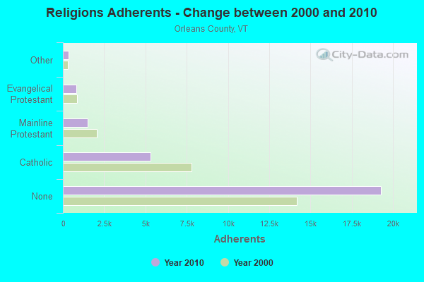
| Religion | Adherents | Congregations |
|---|---|---|
| Catholic | 5,312 | 12 |
| Mainline Protestant | 1,485 | 23 |
| Evangelical Protestant | 822 | 14 |
| Other | 323 | 4 |
| None | 19,289 | - |
Food Environment Statistics:
| This county: | 5.14 / 10,000 pop. |
| Vermont: | 3.84 / 10,000 pop. |
| Orleans County: | 1.10 / 10,000 pop. |
| Vermont: | 1.95 / 10,000 pop. |
| Orleans County: | 6.60 / 10,000 pop. |
| Vermont: | 6.40 / 10,000 pop. |
| Orleans County: | 8.07 / 10,000 pop. |
| Vermont: | 11.52 / 10,000 pop. |
| Orleans County: | 7.0% |
| Vermont: | 6.8% |
| Orleans County: | 24.8% |
| Vermont: | 22.3% |
| Here: | 10.8% |
| Vermont: | 13.3% |
| Businesses in Derby, VT | ||||
| Name | Count | Name | Count | |
|---|---|---|---|---|
| Ace Hardware | 1 | McDonald's | 1 | |
| FedEx | 1 | Rite Aid | 1 | |
| GNC | 1 | Sears | 1 | |
| MasterBrand Cabinets | 2 | Shaw's | 1 | |
| Maurices | 1 | |||
Strongest AM radio stations in Derby:
- WIKE (1490 AM; 1 kW; NEWPORT, VT; Owner: NORTHSTAR MEDIA, INC.)
- WCHP (760 AM; 35 kW; CHAMPLAIN, NY; Owner: CHAMPLAIN RADIO, INC.)
- WICY (1490 AM; 50 kW; MALONE, NY; Owner: CARTIER COMMUNICATIONS INC.)
- WDEV (550 AM; 5 kW; WATERBURY, VT; Owner: RADIO VERMONT, INC.)
- WRKO (680 AM; 50 kW; BOSTON, MA; Owner: ENTERCOM BOSTON LICENSE, LLC)
- WVMT (620 AM; 5 kW; BURLINGTON, VT; Owner: SISON BROADCASTING, INC.)
- WNNZ (640 AM; 50 kW; WESTFIELD, MA; Owner: CLEAR CHANNEL BROADCASTING LICENSES, INC.)
- WGY (810 AM; 50 kW; SCHENECTADY, NY; Owner: CLEAR CHANNEL BROADCASTING LICENSES, INC.)
- WTME (780 AM; 10 kW; RUMFORD, ME; Owner: MOUNTAIN VALLEY BROADCASTING, INC.)
- WCRN (830 AM; 50 kW; WORCESTER, MA; Owner: CARTER BROADCASTING CORPORATION)
- WEEI (850 AM; 50 kW; BOSTON, MA; Owner: ENTERCOM BOSTON LICENSE, LLC)
- WTWN (1100 AM; daytime; 5 kW; WELLS RIVER, VT; Owner: PUFFER BROADCASTING, INC.)
- WBZ (1030 AM; 50 kW; BOSTON, MA; Owner: INFINITY BROADCASTING OPERATIONS, INC.)
Strongest FM radio stations in Derby:
- WMOO (92.1 FM; DERBY CENTER, VT; Owner: NORTHSTAR MEDIA, INC.)
- W243AE (96.5 FM; ORLEANS, VT; Owner: CHRISTIAN MINISTRIES, INC.)
- WGMT (97.7 FM; LYNDON, VT; Owner: VERMONT BROADCAST ASSOCIATES, INC.)
- WLKC (103.3 FM; WATERBURY, VT; Owner: RADIO BROADCASTING SERVICES, INC.)
- WEZF (92.9 FM; BURLINGTON, VT; Owner: CAPSTAR TX LIMITED PARTNERSHIP)
- WVPS (107.9 FM; BURLINGTON, VT; Owner: VERMONT PUBLIC RADIO)
- WPKQ (103.7 FM; NORTH CONWAY, NH; Owner: CITADEL BROADCASTING COMPANY)
- WHOM (94.9 FM; MT. WASHINGTON, NH; Owner: CITADEL BROADCASTING COMPANY)
- WCVT (101.7 FM; STOWE, VT; Owner: RADIO VERMONT CLASSICS, L.L.C.)
- WNCS (104.7 FM; MONTPELIER, VT; Owner: MONTPELIER BROADCASTING, INC.)
- WDOT (95.7 FM; DANVILLE, VT; Owner: MONTPELIER BROADCASTING INC)
- WMTK (106.3 FM; LITTLETON, NH; Owner: VERMONT BROADCAST ASSOCIATES, INC.)
TV broadcast stations around Derby:
- W14CK (Channel 14; NEWPORT, VT; Owner: SMC COMMUNICATIONS, INC.)
- National Bridge Inventory (NBI) Statistics
- 20Number of bridges
- 285ft / 86.6mTotal length
- $1,185,000Total costs
- 80,590Total average daily traffic
- 8,455Total average daily truck traffic

- New bridges - historical statistics
- 81960-1969
- 81970-1979
- 12000-2009
- 22010-2019
- 12020-2022
FCC Registered Cell Phone Towers:
1- Nelson Hill Road (Lat: 44.973111 Lon: -72.073528), Type: Mast, Structure height: 51.5 m, Call Sign: KNKQ284
Assigned Frequencies: 880.020 MHz, 880.020 MHz, 835.020 MHz, 835.020 MHz, 891.510 MHz, 891.510 MHz, 846.510 MHz, 846.510 MHzGrant Date: 08/31/2021, Expiration Date: 10/01/2031, Certifier: Gregory M RomanoRegistrant: Verizon Wireless, 5055 North Point Pkwy, Np2ne Network Engineering, Alpharetta, GA 30022, Phone: (770) 797-1070, Email:
FCC Registered Broadcast Land Mobile Towers:
9 (See the full list of FCC Registered Broadcast Land Mobile Towers in Derby, VT)FCC Registered Microwave Towers:
3- Derby-01, 3557 Nelson Hill Rd (Lat: 44.973083 Lon: -72.073889), Type: Mast, Structure height: 35.1 m, Call Sign: WQUX637,
Assigned Frequencies: 11055.0 MHz, 11095.0 MHz, 11055.0 MHz, 11095.0 MHz, 11055.0 MHz, 11095.0 MHz, 11055.0 MHz, 11095.0 MHz, 11055.0 MHz, 11095.0 MHz... (+62 more), Grant Date: 11/10/2014, Expiration Date: 11/10/2024, Certifier: Fran Stocker, Registrant: Radyn, Inc, Silver Spring, MD 20914, Phone: (301) 493-5171, Fax: (301) 576-4553, Email:
- Derby, State Police Office & Barracks Us Route 5 (Lat: 44.950833 Lon: -72.161389), Type: Tower, Structure height: 5.5 m, Overall height: 15.2 m, Call Sign: WIS86,
Assigned Frequencies: 6545.62 MHz, Grant Date: 01/04/2018, Expiration Date: 03/04/2028, Registrant: State Of Vermont, 45 State Drive, Watterbury, VT 05671, Phone: (802) 229-0882, Fax: (717) 671-0200, Email:
- Derby-Newport/Bx 92 (Lat: 44.953639 Lon: -72.136750), Overall height: 15.2 m, Call Sign: WLQ251,
Assigned Frequencies: 950.500 MHz, Grant Date: 04/29/1991, Expiration Date: 04/01/2030, Registrant: Vermont Broadcast Associates, Inc., Lyndonville, VT 05851
FCC Registered Amateur Radio Licenses:
13 (See the full list of FCC Registered Amateur Radio Licenses in Derby)FAA Registered Aircraft:
1- Aircraft: JESTES MONTE AIRBIKE (Category: Land, Weight: Up to 12,499 Pounds), Engine: ROTAX 503 DCDI (52 HP) (Reciprocating)
N-Number: 343M, N343M, N-343M, Serial Number: 016, Year manufactured: 2009, Airworthiness Date: 08/22/2009, Certificate Issue Date: 08/03/2016
Registrant (Individual): Jessee R Nash, 727 Dumas Rd, Derby, VT 05829
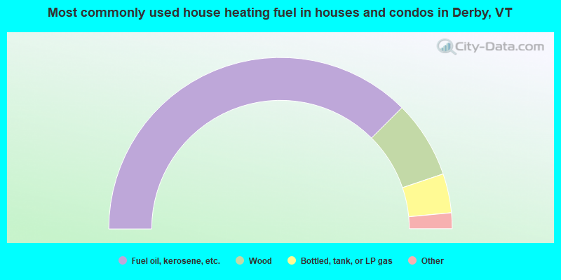
- 75.1%Fuel oil, kerosene, etc.
- 14.6%Wood
- 7.4%Bottled, tank, or LP gas
- 2.5%Electricity
- 0.5%Other fuel
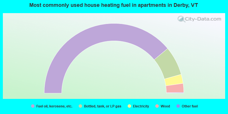
- 78.0%Fuel oil, kerosene, etc.
- 13.4%Bottled, tank, or LP gas
- 4.2%Electricity
- 4.2%Wood
- 0.3%Other fuel
Derby compared to Vermont state average:
- Unemployed percentage below state average.
- Black race population percentage below state average.
- Hispanic race population percentage significantly below state average.
- Length of stay since moving in significantly above state average.
- Number of rooms per house significantly below state average.
- House age significantly below state average.
- Number of college students below state average.
- Percentage of population with a bachelor's degree or higher below state average.
Derby on our top lists:
- #37 on the list of "Top 101 cities with the most residents born in Northern America (population 500+)"
- #37 on the list of "Top 101 cities with the most residents born in Canada (population 500+)"
- #53 (05829) on the list of "Top 101 zip codes with the largest percentage of French Canadian first ancestries"

|
Total of 2 patent applications in 2008-2024.