Jefferson, Maine
Submit your own pictures of this town and show them to the world
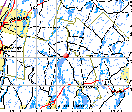
- OSM Map
- General Map
- Google Map
- MSN Map
Population change since 2000: +1.6%
 |
| Males: 1,209 | |
| Females: 1,218 |
| Median resident age: | 46.0 years |
| Maine median age: | 43.0 years |
Zip codes: 04348.
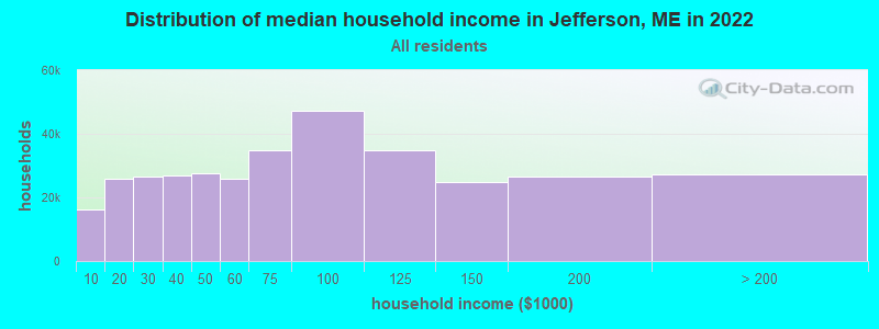
| Jefferson: | $77,605 |
| ME: | $69,543 |
Estimated per capita income in 2022: $44,041 (it was $20,298 in 2000)
Jefferson town income, earnings, and wages data
Estimated median house or condo value in 2022: $313,211 (it was $109,300 in 2000)
| Jefferson: | $313,211 |
| ME: | $290,600 |
Mean prices in 2022: all housing units: $415,956; detached houses: $442,502; townhouses or other attached units: $442,441; in 2-unit structures: $393,150; in 3-to-4-unit structures: $266,359; in 5-or-more-unit structures: $407,319; mobile homes: $150,042; occupied boats, rvs, vans, etc.: $76,651
Detailed information about poverty and poor residents in Jefferson, ME


- 2,35296.9%White alone
- 371.5%Hispanic
- 160.7%Two or more races
- 120.5%American Indian alone
- 40.2%Black alone
- 50.2%Asian alone
- 10.04%Other race alone
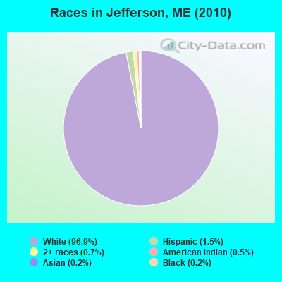
Races in Jefferson detailed stats: ancestries, foreign born residents, place of birth
According to our research of Maine and other state lists, there were 9 registered sex offenders living in Jefferson, Maine as of April 28, 2024.
The ratio of all residents to sex offenders in Jefferson is 270 to 1.
 Recent articles from our blog. Our writers, many of them Ph.D. graduates or candidates, create easy-to-read articles on a wide variety of topics.

 | upstate NY vs Maine (14 replies) |
| Most conservative county & best vehicle in Maine? (36 replies) |
| Bucksport/Verona Island (3 replies) |
| Best Pick Your Own Farms. (17 replies) |
| From Ca to ME (36 replies) |
| Ted Cruz is Coming to Maine Tomorrow (40 replies) |
Latest news from Jefferson, ME collected exclusively by city-data.com from local newspapers, TV, and radio stations
Jefferson, ME City Guides:
Ancestries: English (21.8%), United States (13.3%), Irish (13.0%), German (12.4%), French (7.5%), Scottish (5.7%).
Current Local Time: EST time zone
Incorporated on 02/24/1807
Elevation: 100 feet
Land area: 52.7 square miles.
Population density: 46 people per square mile (very low).
64 residents are foreign born (1.5% Europe, 0.5% North America, 0.3% Latin America).
| This town: | 2.7% |
| Maine: | 2.9% |
| Jefferson town: | 0.8% ($893) |
| Maine: | 1.5% ($1,417) |
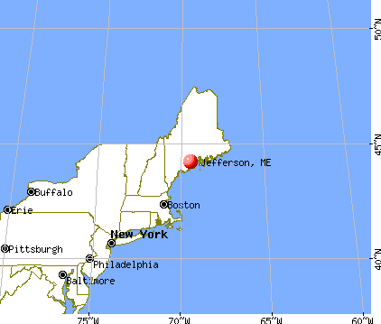
Nearest city with pop. 50,000+: Portland, ME  (52.8 miles , pop. 64,249).
Nearest city with pop. 200,000+: Boston, MA (151.9 miles , pop. 589,141).
Nearest city with pop. 1,000,000+: Bronx, NY (321.1 miles , pop. 1,332,650).
Nearest cities:
), ), ), ), ), Latitude: 44.19 N, Longitude: 69.49 W
Area code commonly used in this area: 207
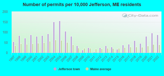
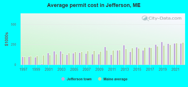
Single-family new house construction building permits:
- 2022: 21 buildings, average cost: $264,500
- 2021: 23 buildings, average cost: $265,100
- 2020: 19 buildings, average cost: $262,500
- 2019: 11 buildings, average cost: $282,200
- 2018: 14 buildings, average cost: $249,800
- 2017: 10 buildings, average cost: $213,500
- 2016: 9 buildings, average cost: $177,800
- 2015: 4 buildings, average cost: $218,800
- 2014: 7 buildings, average cost: $160,700
- 2013: 8 buildings, average cost: $242,500
- 2012: 6 buildings, average cost: $180,000
- 2011: 1 building, cost: $125,000
- 2010: 6 buildings, average cost: $224,000
- 2009: 3 buildings, average cost: $133,300
- 2008: 8 buildings, average cost: $132,500
- 2007: 19 buildings, average cost: $140,300
- 2006: 25 buildings, average cost: $150,000
- 2005: 37 buildings, average cost: $145,300
- 2004: 36 buildings, average cost: $123,800
- 2003: 22 buildings, average cost: $166,800
- 2002: 20 buildings, average cost: $166,800
- 2001: 19 buildings, average cost: $147,400
- 2000: 21 buildings, average cost: $10,000
- 1999: 17 buildings, average cost: $94,000
- 1998: 20 buildings, average cost: $101,800
- 1997: 13 buildings, average cost: $100,400
| Here: | 3.0% |
| Maine: | 3.4% |
- Health care (16.7%)
- Construction (10.5%)
- Educational services (9.5%)
- Public administration (8.1%)
- Transportation equipment (6.1%)
- Agriculture, forestry, fishing & hunting (5.5%)
- Social assistance (3.7%)
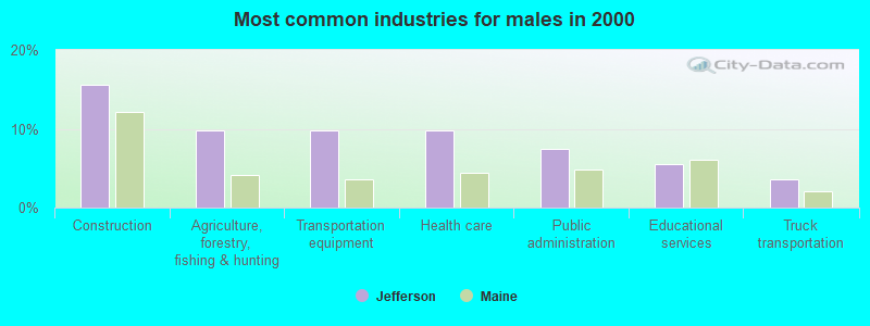
- Construction (15.6%)
- Agriculture, forestry, fishing & hunting (9.8%)
- Transportation equipment (9.8%)
- Health care (9.8%)
- Public administration (7.5%)
- Educational services (5.5%)
- Truck transportation (3.6%)
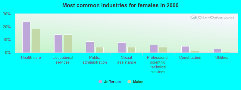
- Health care (24.2%)
- Educational services (13.9%)
- Public administration (8.7%)
- Social assistance (7.8%)
- Professional, scientific, technical services (5.9%)
- Construction (4.8%)
- Utilities (2.8%)
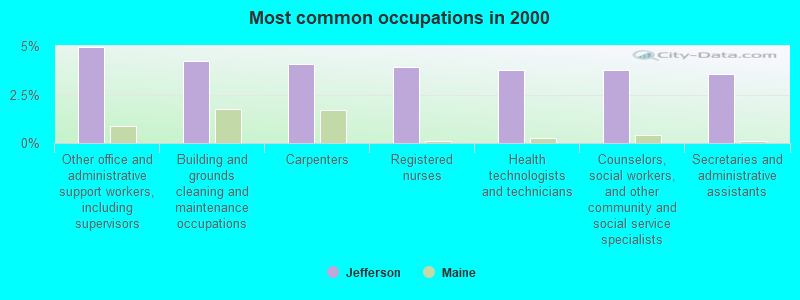
- Other office and administrative support workers, including supervisors (4.9%)
- Building and grounds cleaning and maintenance occupations (4.2%)
- Carpenters (4.1%)
- Registered nurses (3.9%)
- Health technologists and technicians (3.7%)
- Counselors, social workers, and other community and social service specialists (3.7%)
- Secretaries and administrative assistants (3.6%)
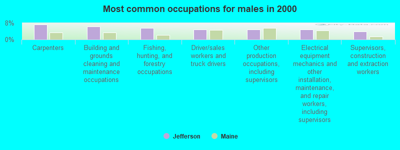
- Carpenters (7.2%)
- Building and grounds cleaning and maintenance occupations (6.3%)
- Fishing, hunting, and forestry occupations (5.5%)
- Driver/sales workers and truck drivers (4.9%)
- Other production occupations, including supervisors (4.9%)
- Electrical equipment mechanics and other installation, maintenance, and repair workers, including supervisors (4.9%)
- Supervisors, construction and extraction workers (3.9%)
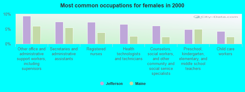
- Other office and administrative support workers, including supervisors (9.4%)
- Secretaries and administrative assistants (7.5%)
- Registered nurses (7.3%)
- Health technologists and technicians (6.6%)
- Counselors, social workers, and other community and social service specialists (6.0%)
- Preschool, kindergarten, elementary, and middle school teachers (4.8%)
- Child care workers (4.3%)
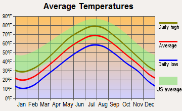
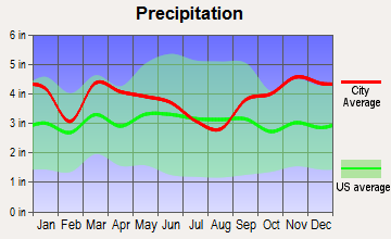
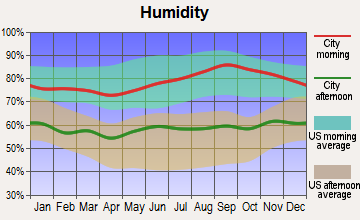
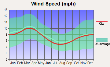
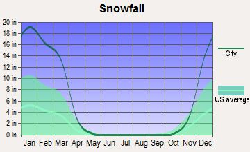
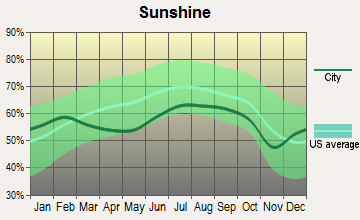
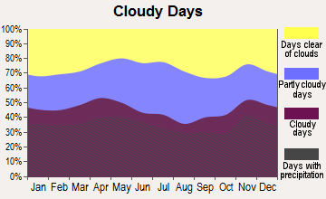
Average climate in Jefferson, Maine
Based on data reported by over 4,000 weather stations
(lower is better)
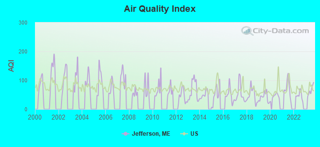
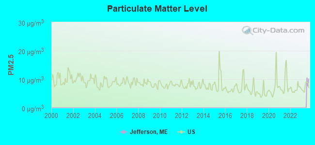
Air Quality Index (AQI) level in 2023 was 66.0. This is about average.
| City: | 66.0 |
| U.S.: | 72.6 |
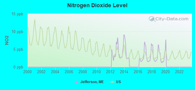
Nitrogen Dioxide (NO2) [ppb] level in 2019 was 2.80. This is significantly better than average. Closest monitor was 14.7 miles away from the city center.
| City: | 2.80 |
| U.S.: | 5.11 |

Sulfur Dioxide (SO2) [ppb] level in 2019 was 0.185. This is significantly better than average. Closest monitor was 14.7 miles away from the city center.
| City: | 0.185 |
| U.S.: | 1.515 |
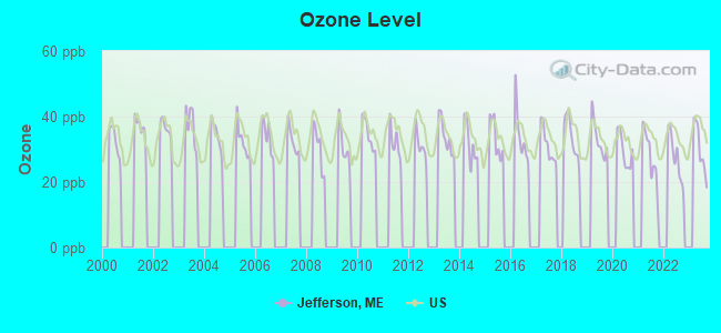
Ozone [ppb] level in 2023 was 30.1. This is about average. Closest monitor was 14.9 miles away from the city center.
| City: | 30.1 |
| U.S.: | 33.3 |
Earthquake activity:
Jefferson-area historical earthquake activity is significantly above Maine state average. It is 77% smaller than the overall U.S. average.On 10/16/2012 at 23:12:25, a magnitude 4.7 (4.7 ML, Depth: 10.0 mi, Class: Light, Intensity: IV - V) earthquake occurred 70.8 miles away from the city center
On 4/20/2002 at 10:50:47, a magnitude 5.3 (5.3 ML, Depth: 3.0 mi, Class: Moderate, Intensity: VI - VII) earthquake occurred 209.1 miles away from Jefferson center
On 4/20/2002 at 10:50:47, a magnitude 5.2 (5.2 MB, 4.2 MS, 5.2 MW, 5.0 MW) earthquake occurred 210.0 miles away from the city center
On 1/19/1982 at 00:14:42, a magnitude 4.7 (4.5 MB, 4.7 MD, 4.5 LG) earthquake occurred 115.3 miles away from Jefferson center
On 10/7/1983 at 10:18:46, a magnitude 5.3 (5.1 MB, 5.3 LG, 5.1 ML) earthquake occurred 241.4 miles away from the city center
On 2/26/1999 at 03:38:43, a magnitude 3.8 (3.8 LG, Depth: 2.0 mi, Class: Light, Intensity: II - III) earthquake occurred 20.4 miles away from the city center
Magnitude types: regional Lg-wave magnitude (LG), body-wave magnitude (MB), duration magnitude (MD), local magnitude (ML), surface-wave magnitude (MS), moment magnitude (MW)
Natural disasters:
The number of natural disasters in Lincoln County (24) is greater than the US average (15).Major Disasters (Presidential) Declared: 19
Emergencies Declared: 4
Causes of natural disasters: Floods: 15, Storms: 11, Winter Storms: 4, Hurricanes: 2, Snows: 2, Winds: 2, Blizzard: 1, Heavy Rain: 1, Ice Storm: 1, Landslide: 1, Snowfall: 1, Tropical Storm: 1, Other: 2 (Note: some incidents may be assigned to more than one category).
Hospitals and medical centers near Jefferson:
- FIELDCREST MANOR (Nursing Home, about 8 miles away; WALDOBORO, ME)
- COVE'S EDGE (Nursing Home, about 12 miles away; DAMARISCOTTA, ME)
- MAINEGENERAL MEDICAL CENTER -GARDINER (Nursing Home, about 14 miles away; GARDINER, ME)
- MERRILL MEMORIAL MANOR (Nursing Home, about 14 miles away; GARDINER, ME)
- ROBINSON HLTH CARE FAC (Nursing Home, about 15 miles away; GARDINER, ME)
- MAINE VETERANS HOME - AUGUSTA (Nursing Home, about 15 miles away; AUGUSTA, ME)
- KINDRED TRANSITIONAL CARE AND REHAB-AUGUSTA (Nursing Home, about 16 miles away; AUGUSTA, ME)
Airports located in Jefferson:
- Robinson Ridge Fld Airport (ME34) (Runways: 1)
Colleges/universities with over 2000 students nearest to Jefferson:
- University of Maine at Augusta (about 19 miles; Augusta, ME; Full-time enrollment: 3,204)
- University of Maine at Farmington (about 47 miles; Farmington, ME; FT enrollment: 2,036)
- Southern Maine Community College (about 53 miles; South Portland, ME; FT enrollment: 4,666)
- University of Southern Maine (about 54 miles; Portland, ME; FT enrollment: 6,647)
- Saint Joseph's College of Maine (about 56 miles; Standish, ME; FT enrollment: 2,010)
- Husson University (about 57 miles; Bangor, ME; FT enrollment: 2,421)
- University of Maine (about 64 miles; Orono, ME; FT enrollment: 8,931)
Public elementary/middle school in Jefferson:
- JEFFERSON VILLAGE SCHOOL (Location: 48 WASHINGTON ROAD, Grades: KG-8)
Points of interest:
Notable locations in Jefferson: Health and Welfare Camp (A), Damariscotta Lake Farm (B), Jefferson Volunteer Fire and Rescue Station 2 (C), Jefferson Volunteer Fire and Rescue Station 1 (D), Jefferson Volunteer Fire and Rescue Storage (E). Display/hide their locations on the map
Churches in Jefferson include: United Church (A), Bunker Hill Church (B), First Baptist Church (C), Saint Giles Church (D). Display/hide their locations on the map
Cemeteries: Weeks Cemetery (1), Shepherd Cemetery (2), Fairview Cemetery (3), Trask Lawn Cemetery (4), Highland Cemetery (5), Hopkins Cemetery (6), Ford Cemetery (7). Display/hide their locations on the map
Lakes and reservoirs: Travel Pond (A), Deer Meadow Pond (B), Flood Pond (C), Horn Pond (D), Kerr Pond (E), Little Dyer Pond (F), Musquash Pond (G), Dyer Long Pond (H). Display/hide their locations on the map
Streams, rivers, and creeks: Brann Brook (A), Davis Stream (B), Pitcher Brook (C), Black Brook (D). Display/hide their locations on the map
Park in Jefferson: Damariscotta Lake State Park (1). Display/hide its location on the map
Birthplace of: Oakes Murphy - Politician.
Drinking water stations with addresses in Jefferson and their reported violations in the past:
AOS 93 JEFFERSON VILLAGE SCHOOL (Population served: 330, Groundwater):Past health violations:MDOC ST PK - DAMARISCOTTA LAKE (Population served: 175, Groundwater):Past monitoring violations:
- MCL, Monthly (TCR) - In OCT-2011, Contaminant: Coliform. Follow-up actions: St Tech Assistance Visit (OCT-24-2011), St Compliance Meeting conducted (OCT-24-2011), St Boil Water Order (OCT-24-2011), St Public Notif requested (OCT-24-2011), St Formal NOV issued (OCT-24-2011), St Compliance achieved (NOV-28-2011), St Public Notif received (NOV-30-2011)
- Follow-up Or Routine LCR Tap M/R - In OCT-01-2013, Contaminant: Lead and Copper Rule. Follow-up actions: St Public Notif requested (NOV-13-2013), St Formal NOV issued (NOV-13-2013), St Public Notif received (NOV-21-2013)
- Follow-up Or Routine LCR Tap M/R - In JUL-11-2004, Contaminant: Lead and Copper Rule. Follow-up actions: St Public Notif requested (NOV-21-2005), St Violation/Reminder Notice (NOV-21-2005), St Compliance achieved (FEB-17-2006), St Public Notif received (FEB-17-2006)
- 2 routine major monitoring violations
Past monitoring violations:DAMARISCOTTA LAKE COTTAGE CONDO ASSOC (Population served: 52, Groundwater):
- 3 regular monitoring violations
Past monitoring violations:
- One regular monitoring violation
| This town: | 2.4 people |
| Maine: | 2.3 people |
| This town: | 69.6% |
| Whole state: | 62.9% |
| This town: | 8.9% |
| Whole state: | 9.4% |
Likely homosexual households (counted as self-reported same-sex unmarried-partner households)
- Lesbian couples: 0.7% of all households
- Gay men: 0.3% of all households
| This town: | 12.3% |
| Whole state: | 10.9% |
| This town: | 5.0% |
| Whole state: | 4.1% |
5 people in other group homes in 2000
For population 15 years and over in Jefferson:
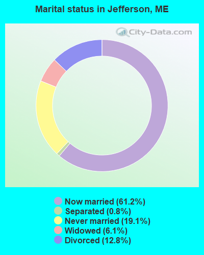
- Never married: 19.1%
- Now married: 61.2%
- Separated: 0.8%
- Widowed: 6.1%
- Divorced: 12.8%
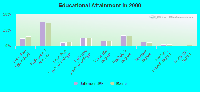
For population 25 years and over in Jefferson:
- High school or higher: 88.2%
- Bachelor's degree or higher: 24.3%
- Graduate or professional degree: 8.0%
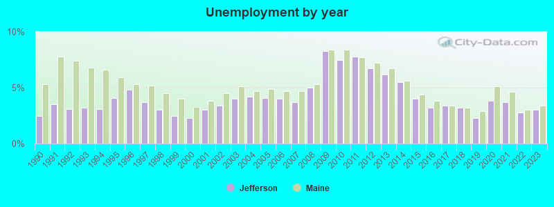
- Unemployed: 4.6%
- Mean travel time to work (commute): 29.7 minutes
| Here: | 10.3 |
| Maine average: | 11.2 |
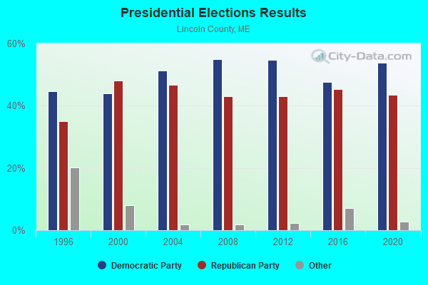
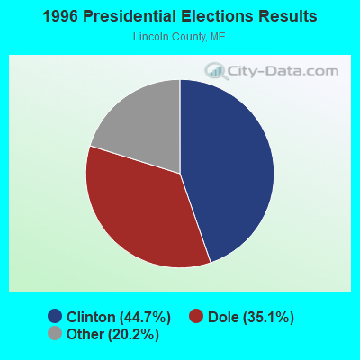
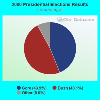
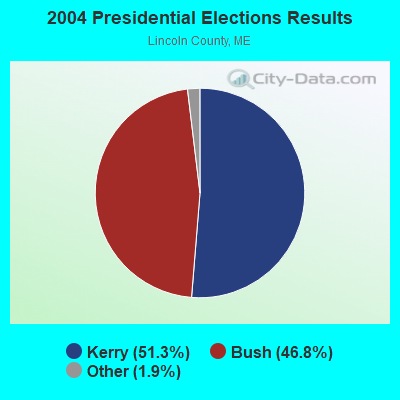

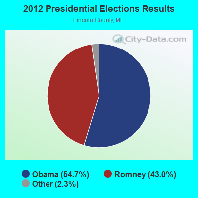
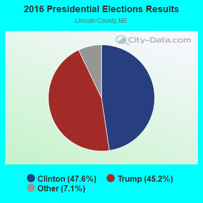
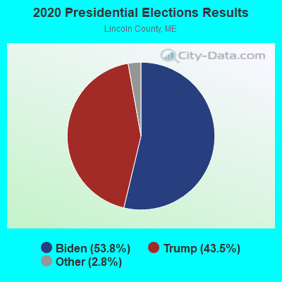
Graphs represent county-level data. Detailed 2008 Election Results
Religion statistics for Jefferson, ME (based on Lincoln County data)
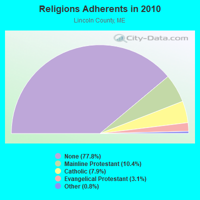

| Religion | Adherents | Congregations |
|---|---|---|
| Mainline Protestant | 3,586 | 29 |
| Catholic | 2,725 | 3 |
| Evangelical Protestant | 1,065 | 12 |
| Other | 279 | 4 |
| None | 26,802 | - |
Food Environment Statistics:
| This county: | 4.03 / 10,000 pop. |
| Maine: | 2.80 / 10,000 pop. |
| This county: | 2.59 / 10,000 pop. |
| Maine: | 2.20 / 10,000 pop. |
| Lincoln County: | 6.62 / 10,000 pop. |
| State: | 5.75 / 10,000 pop. |
| This county: | 13.23 / 10,000 pop. |
| Maine: | 11.02 / 10,000 pop. |
| Lincoln County: | 7.0% |
| Maine: | 8.2% |
| This county: | 21.9% |
| State: | 25.0% |
Businesses in Jefferson, ME
- MasterBrand Cabinets: 2
Strongest AM radio stations in Jefferson:
- WFAU (1280 AM; 5 kW; GARDINER, ME; Owner: CAPSTAR TX LIMITED PARTNERSHIP)
- WSKW (1160 AM; 10 kW; SKOWHEGAN, ME; Owner: MOUNTAIN WIRELESS, INCORPORATED)
- WTME (780 AM; 10 kW; RUMFORD, ME; Owner: MOUNTAIN VALLEY BROADCASTING, INC.)
- WRKO (680 AM; 50 kW; BOSTON, MA; Owner: ENTERCOM BOSTON LICENSE, LLC)
- WMTW (870 AM; 10 kW; GORHAM, ME; Owner: RADIO PARTNERS OF MAINE, L.P.)
- WEZW (1400 AM; 1 kW; AUGUSTA, ME; Owner: CITADEL BROADCASTING COMPANY)
- WGAN (560 AM; 5 kW; PORTLAND, ME; Owner: SAGA COMMUNICATIONS OF NEW ENGLAND, LLC)
- WMDR (1340 AM; 1 kW; AUGUSTA, ME; Owner: LIGHT OF LIFE MINISTRIES, INC.)
- WZON (620 AM; 5 kW; BANGOR, ME; Owner: THE ZONE CORPORATION)
- WLAM (1470 AM; 5 kW; LEWISTON, ME; Owner: RADIO PARTNERS OF MAINE, L.P.)
- WEEI (850 AM; 50 kW; BOSTON, MA; Owner: ENTERCOM BOSTON LICENSE, LLC)
- WBZ (1030 AM; 50 kW; BOSTON, MA; Owner: INFINITY BROADCASTING OPERATIONS, INC.)
- WRKD (1450 AM; 1 kW; ROCKLAND, ME; Owner: CLEAR CHANNEL BROADCASTING LICENSES, INC.)
Strongest FM radio stations in Jefferson:
- WMEP (90.5 FM; CAMDEN, ME; Owner: MAINE PUBLIC BROADCASTING CORP.)
- WQSS (102.5 FM; CAMDEN, ME; Owner: CLEAR CHANNEL BROADCASTING LICENSES, INC.)
- WMCM (103.3 FM; ROCKLAND, ME; Owner: CLEAR CHANNEL BROADCASTING LICENSES, INC.)
- WCME (96.7 FM; BOOTHBAY HARBOR, ME; Owner: CAPSTAR TX LIMITED PARTNERSHIP)
- WMME-FM (92.3 FM; AUGUSTA, ME; Owner: CITADEL BROADCASTING COMPANY)
- WBQX (106.9 FM; THOMASTON, ME; Owner: MARINER BROADCASTING LIMITED PARTNER)
- WWWA (95.3 FM; WINSLOW, ME; Owner: LIGHT OF LIFE MINISTRIES, INC.)
- WFZX (101.7 FM; SEARSPORT, ME; Owner: CLEAR CHANNEL BROADCASTING LICENSES, INC.)
- WWBX (97.1 FM; BANGOR, ME; Owner: CLEAR CHANNEL BROADCASTING LICENSES, INC.)
- WCYI (93.9 FM; LEWISTON, ME; Owner: CITADEL BROADCASTING COMPANY)
- WBFB (104.7 FM; BELFAST, ME; Owner: CLEAR CHANNEL BROADCASTING LICENSES, INC.)
- WBCI (105.9 FM; BATH, ME; Owner: BLOUNT COMMUNICATIONS, INC.)
- WABK-FM (104.3 FM; GARDINER, ME; Owner: CAPSTAR TX LIMITED PARTNERSHIP)
- WBLM (102.9 FM; PORTLAND, ME; Owner: CITADEL BROADCASTING COMPANY)
- WKCG (101.3 FM; AUGUSTA, ME; Owner: CAPSTAR TX LIMITED PARTNERSHIP)
- WTHT (107.5 FM; LEWISTON, ME; Owner: RADIO PARTNERS OF MAINE, L.P.)
- WCLZ (98.9 FM; BRUNSWICK, ME; Owner: CITADEL BROADCASTING COMPANY)
- WMEW (91.3 FM; WATERVILLE, ME; Owner: MAINE PUBLIC BROADCASTING CORPORATION)
TV broadcast stations around Jefferson:
- WPFO (Channel 23; WATERVILLE, ME; Owner: CMCG PORTLAND LICENSE LLC)
- WGME-TV (Channel 13; PORTLAND, ME; Owner: WGME LICENSEE, LLC)
- WCBB (Channel 10; AUGUSTA, ME; Owner: MAINE PUBLIC BROADCASTING CORP.)
- W64BY (Channel 64; ROCKLAND, ME; Owner: CRAIG MINISTRIES, INC.)
- WFYW-LP (Channel 69; FAIRFIELD/WATERVILLE, ME; Owner: THREE ANGELS BROADCASTING NETWORK, INC.)
- National Bridge Inventory (NBI) Statistics
- 4Number of bridges
- 16ft / 5.3mTotal length
- 905,330Total average daily traffic
- 45,265Total average daily truck traffic
- 6,370Total future (year 2036) average daily traffic
FCC Registered Cell Phone Towers:
1 (See the full list of FCC Registered Cell Phone Towers in Jefferson)FCC Registered Antenna Towers:
16 (See the full list of FCC Registered Antenna Towers)FCC Registered Broadcast Land Mobile Towers:
4- US CELL TOWER, 1.5 Mi N (Lat: 44.224444 Lon: -69.463889), Type: Gtower, Structure height: 91.4 m, Overall height: 96 m, Call Sign: KNID260,
Assigned Frequencies: 151.040 MHz, Grant Date: 11/29/2023, Expiration Date: 01/03/2034, Registrant: Radio Communications Management, 158 Rand Rd, Portland, ME 04103, Phone: (207) 797-7503, Email:
- Damariscotta Lake St Pk Rt 32 (Lat: 44.197306 Lon: -69.452833), Structure height: 3 m, Call Sign: WPDC206,
Assigned Frequencies: 159.240 MHz, Grant Date: 06/28/2023, Expiration Date: 09/01/2033, Registrant: State Of Maine, O.I.T., Radio Operations, 66 Industrial Drive, Augusta, ME 04333-0147, Phone: (207) 624-9990, Email:
- Fire Tower Rd (Lat: 44.224528 Lon: -69.463778), Type: Ltower, Structure height: 48 m, Call Sign: WQMR441,
Assigned Frequencies: 154.070 MHz, Grant Date: 10/27/2020, Expiration Date: 10/28/2030, Certifier: Ryan A Gallagher, Registrant: Radio Communications Management, 158 Ran Rd, Portland, ME 04103, Phone: (207) 797-7503, Fax: (386) 322-2502, Email:
- Fire Tower Rd Off N Mt Rd (Lat: 44.224500 Lon: -69.463778), Type: Tower, Structure height: 60 m, Call Sign: WQNE244,
Assigned Frequencies: 4967.50 MHz, Grant Date: 11/19/2020, Expiration Date: 01/05/2031, Certifier: Kathy Blagdon, Registrant: Lincoln County 911, 34 Bath Rd, Wiscasset, ME 04578, Phone: (207) 882-7332, Fax: (207) 882-4325, Email:
FCC Registered Microwave Towers:
6- Jefferson, 1.29 Km West Of Sr-206; .16 Km E Of Mt. Rd.; 3.17 Km N Of (Lat: 44.234444 Lon: -69.460000), Type: Tower, Structure height: 61 m, Overall height: 68.6 m, Call Sign: WQIG715,
Assigned Frequencies: 6760.62 MHz, Grant Date: 02/05/2008, Expiration Date: 02/05/2018, Cancellation Date: 02/18/2014, Certifier: Scott Donlea, Registrant: Verizon Wireless, 1120 Sanctuary Pkwy, #150 Gasa5reg, Alpharetta, GA 30009-7630, Phone: (770) 797-1070, Fax: (770) 797-1036, Email:
- JEFFERSON, 1.5 Mi N (Lat: 44.224444 Lon: -69.463889), Type: Gtower, Structure height: 91.4 m, Overall height: 96 m, Call Sign: WQJG827,
Assigned Frequencies: 6256.54 MHz, 6315.84 MHz, Grant Date: 09/18/2018, Expiration Date: 09/04/2028, Certifier: John E Rooney, Registrant: Wilkinson Barker Knauer, LLP, 1800 M Street Nw, Suite 800n, Washington, DC 20036, Phone: (202) 383-3420, Fax: (202) 783-5851, Email:
- Jefferson South, 19 Ridge Road (Lat: 44.125500 Lon: -69.547611), Type: Ltower, Structure height: 58.2 m, Overall height: 58.8 m, Call Sign: WQSK795,
Assigned Frequencies: 10815.0 MHz, 10815.0 MHz, 10815.0 MHz, 10815.0 MHz, 10815.0 MHz, 10815.0 MHz, 10815.0 MHz, 10815.0 MHz, 10815.0 MHz, Grant Date: 10/22/2013, Expiration Date: 10/22/2023, Cancellation Date: 05/18/2020, Certifier: Jessica B Lyons, Registrant: At&t Services, Inc., 208 S Akard St, Rm 2100, Dallas, TX 75202, Phone: (855) 699-7073, Fax: (214) 746-6410, Email:
- Jefferson East, 65 Fire Tower Road (Lat: 44.224528 Lon: -69.463833), Type: Gtower, Structure height: 92.4 m, Overall height: 95.1 m, Call Sign: WQSZ782,
Assigned Frequencies: 11225.0 MHz, 11225.0 MHz, 11225.0 MHz, 11225.0 MHz, 11225.0 MHz, 11225.0 MHz, 11225.0 MHz, 11225.0 MHz, 11225.0 MHz, 11265.0 MHz... (+8 more), Grant Date: 12/16/2013, Expiration Date: 12/16/2023, Cancellation Date: 07/24/2020, Certifier: Jessica B Lyons, Registrant: At&t Services, Inc., 208 S. Akard Street, Room 2100, Dallas, TX 75202, Phone: (855) 699-7073, Email:
- Jefferson Haskell Hi, 1.5 Mi N (Lat: 44.224444 Lon: -69.463889), Type: Pole, Structure height: 91.4 m, Overall height: 96 m, Call Sign: WRFA722,
Assigned Frequencies: 11325.0 MHz, 11325.0 MHz, 11405.0 MHz, 11405.0 MHz, 11325.0 MHz, 11325.0 MHz, 11405.0 MHz, 11405.0 MHz, 11325.0 MHz, 11325.0 MHz... (+6 more), Grant Date: 01/16/2020, Expiration Date: 01/16/2030, Certifier: Jim Mckenna, Registrant: Intelpath, Hinsdale, IL 60522, Phone: (312) 841-9188, Email:
- JEFFERSON, 1.5 Mi N (Lat: 44.224444 Lon: -69.463889), Type: Gtower, Structure height: 91.4 m, Overall height: 96 m, Call Sign: WRVS796,
Assigned Frequencies: 6615.00 MHz, 6615.00 MHz, 6615.00 MHz, 6615.00 MHz, 6615.00 MHz, 6615.00 MHz, 6615.00 MHz, 6615.00 MHz, Grant Date: 01/02/2023, Expiration Date: 01/02/2033, Certifier: Tara A Doe, Registrant: Radio Communications Management Inc., 158 Rand Road, Rcm, Portland, ME 04102, Phone: (207) 797-7503, Email:
FCC Registered Amateur Radio Licenses:
22 (See the full list of FCC Registered Amateur Radio Licenses in Jefferson)FAA Registered Aircraft:
3- Aircraft: PIPER PA-22-150 (Category: Land, Seats: 4, Weight: Up to 12,499 Pounds, Speed: 94 mph), Engine: LYCOMING 0-320 SERIES (180 HP) (Reciprocating)
N-Number: 474VM, N474VM, N-474VM, Serial Number: 22-4173, Year manufactured: 1956, Airworthiness Date: 06/25/1981, Certificate Issue Date: 01/21/2005
Registrant (Co-Owned): Malcolm O Peck, 474 Waldoboro Rd, Jefferson, ME 04348, Other Owners: Virginia H Peck - Aircraft: PIPER PA-18 (Category: Land, Seats: 2, Weight: Up to 12,499 Pounds, Speed: 97 mph), Engine: LYCOMING 0-290 SERIES (140 HP) (Reciprocating)
N-Number: 65889, N65889, N-65889, Serial Number: 18-946, Year manufactured: 1951, Airworthiness Date: 03/07/2002, Certificate Issue Date: 10/04/2016
Registrant (Individual): Bruce C Hallowell, 79 Benhall Ln, Jefferson, ME 04348 - Aircraft: CESSNA 150F (Category: Land, Seats: 2, Weight: Up to 12,499 Pounds, Speed: 90 mph), Engine: CONT MOTOR 0-200 SERIES (100 HP) (Reciprocating)
N-Number: 8635S, N8635S, N-8635S, Serial Number: 15061935, Airworthiness Date: 09/10/1965, Certificate Issue Date: 08/03/2018
Registrant (Partnership): Timothy M Wood, 53 Somerville Rd, Jefferson, ME 04348, Other Owners: Jodi S Wood
2003 - 2018 National Fire Incident Reporting System (NFIRS) incidents
- Fire incident types reported to NFIRS in Jefferson, ME
- 11063.2%Structure Fires
- 4023.0%Outside Fires
- 179.8%Mobile Property/Vehicle Fires
- 74.0%Other
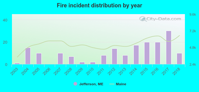 According to the data from the years 2003 - 2018 the average number of fire incidents per year is 11. The highest number of reported fire incidents - 30 took place in 2017, and the least - 0 in 2006. The data has a growing trend.
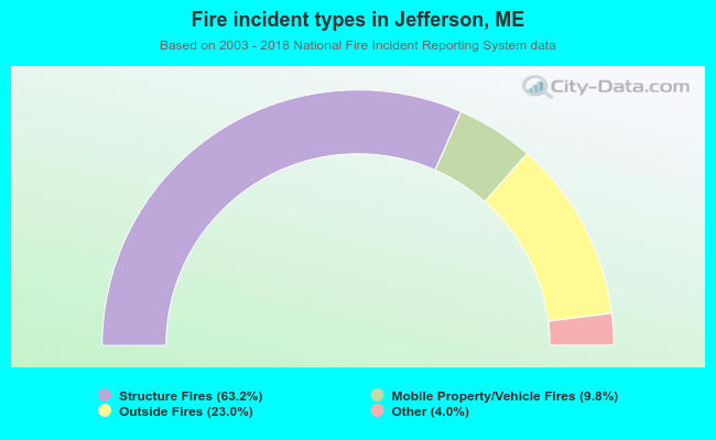 When looking into fire subcategories, the most reports belonged to: Structure Fires (63.2%), and Outside Fires (23.0%).
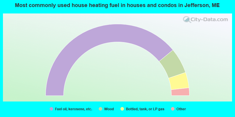
- 78.0%Fuel oil, kerosene, etc.
- 11.5%Wood
- 7.0%Bottled, tank, or LP gas
- 3.0%Electricity
- 0.5%Other fuel
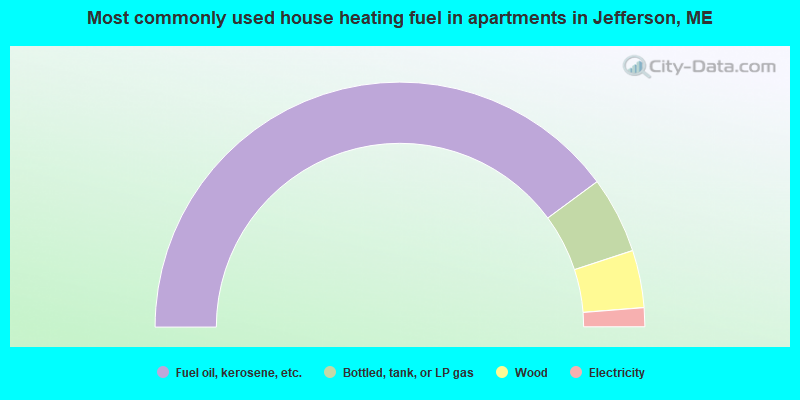
- 79.8%Fuel oil, kerosene, etc.
- 10.1%Bottled, tank, or LP gas
- 7.6%Wood
- 2.5%Electricity
Jefferson compared to Maine state average:
- Unemployed percentage below state average.
- Black race population percentage significantly below state average.
- Renting percentage below state average.
- Length of stay since moving in significantly above state average.
- Number of rooms per house significantly below state average.
- House age significantly below state average.

|
Total of 1 patent application in 2008-2024.