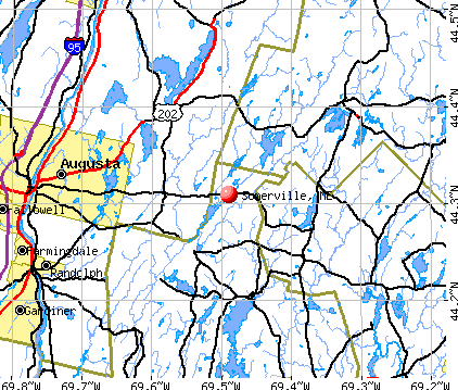
Somerville, Maine
Submit your own pictures of this town and show them to the world
- OSM Map
- General Map
- Google Map
- MSN Map
Population change since 2000: +7.7%
 |
| Males: 285 | |
| Females: 263 |
| Median resident age: | 44.0 years |
| Maine median age: | 43.0 years |
Zip codes: 04348.
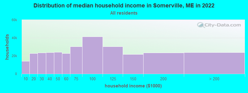
| Somerville: | $68,093 |
| ME: | $69,543 |
Estimated per capita income in 2022: $34,512 (it was $15,906 in 2000)
Somerville town income, earnings, and wages data
Estimated median house or condo value in 2022: $218,646 (it was $76,300 in 2000)
| Somerville: | $218,646 |
| ME: | $290,600 |
Mean prices in 2022: all housing units: $415,956; detached houses: $442,502; townhouses or other attached units: $442,441; in 2-unit structures: $393,150; in 3-to-4-unit structures: $266,359; in 5-or-more-unit structures: $407,319; mobile homes: $150,042; occupied boats, rvs, vans, etc.: $76,651
Detailed information about poverty and poor residents in Somerville, ME


- 51694.2%White alone
- 152.7%Hispanic
- 101.8%Asian alone
- 61.1%Two or more races
- 10.2%Black alone
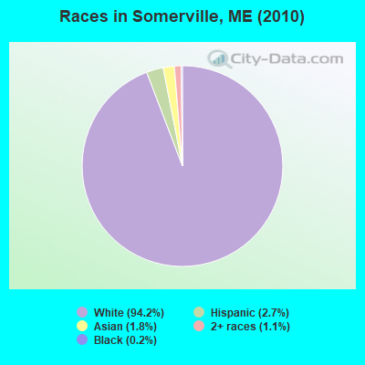
Races in Somerville detailed stats: ancestries, foreign born residents, place of birth
According to our research of Maine and other state lists, there were 3 registered sex offenders living in Somerville, Maine as of April 26, 2024.
The ratio of all residents to sex offenders in Somerville is 183 to 1.
 Recent articles from our blog. Our writers, many of them Ph.D. graduates or candidates, create easy-to-read articles on a wide variety of topics.

 | What makes South Berwick so wonderful? (0 replies) |
| where should we move in maine? (16 replies) |
| Working in Winslow, Maine (4 replies) |
| The question is: better to live in Portland or Portsmouth?? (37 replies) |
| portland, me vs. burlington, vt (16 replies) |
| Maine's Off Topic Thread -- Part 5 (475 replies) |
Latest news from Somerville, ME collected exclusively by city-data.com from local newspapers, TV, and radio stations
Ancestries: United States (20.4%), English (15.9%), German (12.0%), Irish (11.0%), French (7.5%), French Canadian (4.3%).
Current Local Time: EST time zone
Incorporated on 03/25/1858
Elevation: 232 feet
Land area: 21.9 square miles.
Population density: 25 people per square mile (very low).
10 residents are foreign born
| This town: | 2.0% |
| Maine: | 2.9% |
| Somerville town: | 1.1% ($848) |
| Maine: | 1.5% ($1,417) |
Nearest city with pop. 50,000+: Portland, ME  (58.2 miles , pop. 64,249).
Nearest city with pop. 200,000+: Boston, MA (158.2 miles , pop. 589,141).
Nearest city with pop. 1,000,000+: Bronx, NY (326.5 miles , pop. 1,332,650).
Nearest cities:
), ), ), ), )Latitude: 44.29 N, Longitude: 69.49 W
Area code commonly used in this area: 207

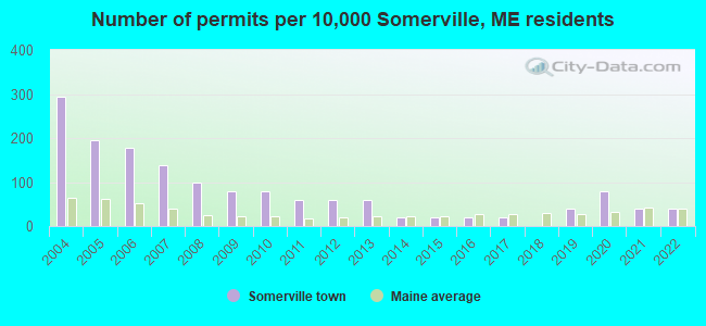
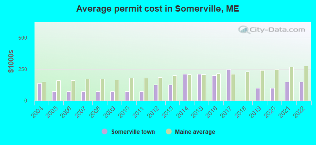
Single-family new house construction building permits:
- 2022: 2 buildings, average cost: $150,000
- 2021: 2 buildings, average cost: $150,000
- 2020: 4 buildings, average cost: $100,000
- 2019: 2 buildings, average cost: $100,000
- 2017: 1 building, cost: $248,100
- 2016: 1 building, cost: $200,000
- 2015: 1 building, cost: $211,200
- 2014: 1 building, cost: $211,200
- 2013: 3 buildings, average cost: $125,000
- 2012: 3 buildings, average cost: $125,000
- 2011: 3 buildings, average cost: $71,800
- 2010: 4 buildings, average cost: $71,800
- 2009: 4 buildings, average cost: $71,800
- 2008: 5 buildings, average cost: $71,800
- 2007: 7 buildings, average cost: $71,800
- 2006: 9 buildings, average cost: $71,800
- 2005: 10 buildings, average cost: $71,800
- 2004: 15 buildings, average cost: $138,800
| Here: | 4.2% |
| Maine: | 3.4% |

- Public administration (17.0%)
- Health care (10.5%)
- Construction (8.3%)
- Educational services (8.3%)
- Agriculture, forestry, fishing & hunting (4.8%)
- Accommodation & food services (4.4%)
- Professional, scientific, technical services (3.9%)
- Construction (16.7%)
- Public administration (14.0%)
- Agriculture, forestry, fishing & hunting (6.1%)
- Building material & garden equipment & supplies dealers (6.1%)
- Transportation equipment (6.1%)
- Metal & metal products (5.3%)
- Arts, entertainment, recreation (5.3%)
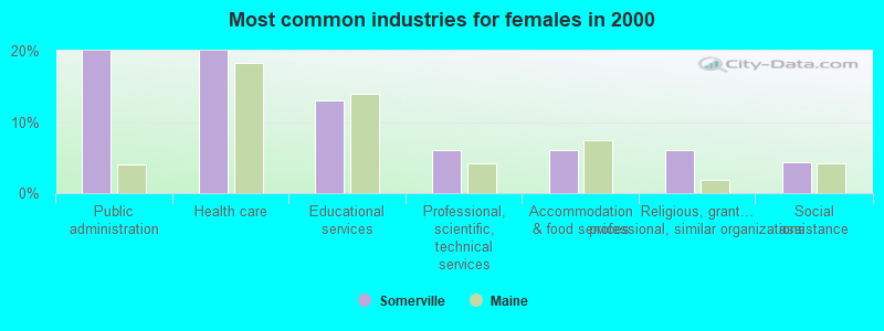
- Public administration (20.0%)
- Health care (20.0%)
- Educational services (13.0%)
- Professional, scientific, technical services (6.1%)
- Accommodation & food services (6.1%)
- Religious, grantmaking, civic, professional, similar organizations (6.1%)
- Social assistance (4.3%)
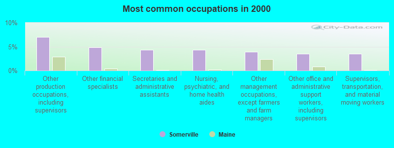
- Other production occupations, including supervisors (7.0%)
- Other financial specialists (4.8%)
- Secretaries and administrative assistants (4.4%)
- Nursing, psychiatric, and home health aides (4.4%)
- Other management occupations, except farmers and farm managers (3.9%)
- Other office and administrative support workers, including supervisors (3.5%)
- Supervisors, transportation, and material moving workers (3.5%)
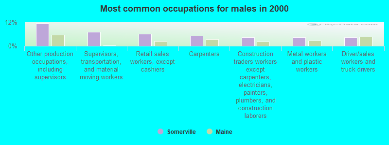
- Other production occupations, including supervisors (11.4%)
- Supervisors, transportation, and material moving workers (7.0%)
- Retail sales workers, except cashiers (6.1%)
- Carpenters (5.3%)
- Construction traders workers except carpenters, electricians, painters, plumbers, and construction laborers (4.4%)
- Metal workers and plastic workers (4.4%)
- Driver/sales workers and truck drivers (4.4%)

- Secretaries and administrative assistants (8.7%)
- Nursing, psychiatric, and home health aides (8.7%)
- Other financial specialists (7.8%)
- Other management occupations, except farmers and farm managers (6.1%)
- Other office and administrative support workers, including supervisors (5.2%)
- Counselors, social workers, and other community and social service specialists (5.2%)
- Other teachers, instructors, education, training, and library occupations (4.3%)
Average climate in Somerville, Maine
Based on data reported by over 4,000 weather stations


(lower is better)
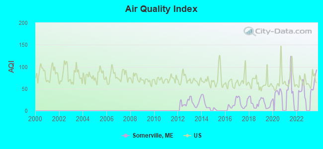
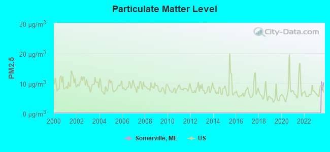
Air Quality Index (AQI) level in 2023 was 62.3. This is about average.
| City: | 62.3 |
| U.S.: | 72.6 |
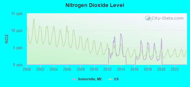
Nitrogen Dioxide (NO2) [ppb] level in 2019 was 2.80. This is significantly better than average. Closest monitor was 14.1 miles away from the city center.
| City: | 2.80 |
| U.S.: | 5.11 |
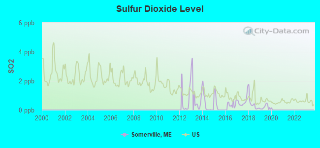
Sulfur Dioxide (SO2) [ppb] level in 2019 was 0.185. This is significantly better than average. Closest monitor was 13.8 miles away from the city center.
| City: | 0.185 |
| U.S.: | 1.515 |
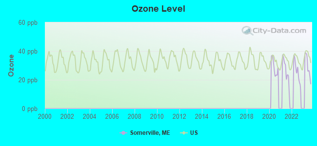
Ozone [ppb] level in 2023 was 29.5. This is about average. Closest monitor was 14.1 miles away from the city center.
| City: | 29.5 |
| U.S.: | 33.3 |
Earthquake activity:
Somerville-area historical earthquake activity is significantly above Maine state average. It is 77% smaller than the overall U.S. average.On 10/16/2012 at 23:12:25, a magnitude 4.7 (4.7 ML, Depth: 10.0 mi, Class: Light, Intensity: IV - V) earthquake occurred 75.4 miles away from the city center
On 4/20/2002 at 10:50:47, a magnitude 5.3 (5.3 ML, Depth: 3.0 mi, Class: Moderate, Intensity: VI - VII) earthquake occurred 208.7 miles away from Somerville center
On 4/20/2002 at 10:50:47, a magnitude 5.2 (5.2 MB, 4.2 MS, 5.2 MW, 5.0 MW) earthquake occurred 209.6 miles away from Somerville center
On 1/19/1982 at 00:14:42, a magnitude 4.7 (4.5 MB, 4.7 MD, 4.5 LG) earthquake occurred 118.7 miles away from Somerville center
On 10/7/1983 at 10:18:46, a magnitude 5.3 (5.1 MB, 5.3 LG, 5.1 ML) earthquake occurred 242.2 miles away from Somerville center
On 2/26/1999 at 03:38:43, a magnitude 3.8 (3.8 LG, Depth: 2.0 mi, Class: Light, Intensity: II - III) earthquake occurred 13.3 miles away from the city center
Magnitude types: regional Lg-wave magnitude (LG), body-wave magnitude (MB), duration magnitude (MD), local magnitude (ML), surface-wave magnitude (MS), moment magnitude (MW)
Natural disasters:
The number of natural disasters in Lincoln County (24) is greater than the US average (15).Major Disasters (Presidential) Declared: 19
Emergencies Declared: 4
Causes of natural disasters: Floods: 15, Storms: 11, Winter Storms: 4, Hurricanes: 2, Snows: 2, Winds: 2, Blizzard: 1, Heavy Rain: 1, Ice Storm: 1, Landslide: 1, Snowfall: 1, Tropical Storm: 1, Other: 2 (Note: some incidents may be assigned to more than one category).
Hospitals and medical centers near Somerville:
- MAINE VETERANS HOME - AUGUSTA (Nursing Home, about 13 miles away; AUGUSTA, ME)
- FIELDCREST MANOR (Nursing Home, about 14 miles away; WALDOBORO, ME)
- KINDRED TRANSITIONAL CARE AND REHAB-AUGUSTA (Nursing Home, about 14 miles away; AUGUSTA, ME)
- MAINE GENERAL REHAB AND NURSING AT GLENRIDGE (Nursing Home, about 14 miles away; AUGUSTA, ME)
- SUPPORTIVE LIVING SYSTEMS INC (Home Health Center, about 15 miles away; AUGUSTA, ME)
- RIVERVIEW PSYCHIATRIC CENTER (Hospital, about 15 miles away; AUGUSTA, ME)
- KENNEBEC VALLEY MEDICAL CENTER (Hospital, about 15 miles away; AUGUSTA, ME)
Colleges/universities with over 2000 students nearest to Somerville:
- University of Maine at Augusta (about 16 miles; Augusta, ME; Full-time enrollment: 3,204)
- University of Maine at Farmington (about 42 miles; Farmington, ME; FT enrollment: 2,036)
- Husson University (about 51 miles; Bangor, ME; FT enrollment: 2,421)
- Southern Maine Community College (about 58 miles; South Portland, ME; FT enrollment: 4,666)
- University of Maine (about 58 miles; Orono, ME; FT enrollment: 8,931)
- University of Southern Maine (about 59 miles; Portland, ME; FT enrollment: 6,647)
- Saint Joseph's College of Maine (about 60 miles; Standish, ME; FT enrollment: 2,010)
Public school in Somerville:
- SOMERVILLE ELEMENTARY SCHOOL (Location: 665 PATRICKTOWN RD SUITE 2, Grades: PK)
Points of interest:
Lakes and reservoirs: Dodge Pond (A), James Pond (B), Long Pond (C), French Pond (D). Display/hide their locations on the map
Streams, rivers, and creeks: Lovejoy Stream (A), Crummett Brook (B), Jones Brook (C). Display/hide their locations on the map
Drinking water stations with addresses in Somerville and their reported violations in the past:
RSU 12 SOMERVILLE ELEMENTARY SCHOOL (Population served: 55, Groundwater):Past monitoring violations:
- Monitoring and Reporting (DBP) - Between JAN-2008 and DEC-2010, Contaminant: Total Haloacetic Acids (HAA5). Follow-up actions: St Public Notif requested (MAR-04-2011), St Formal NOV issued (MAR-04-2011), St Compliance achieved (AUG-22-2011), St Public Notif received (JUN-08-2012)
- Monitoring and Reporting (DBP) - Between JAN-2008 and DEC-2010, Contaminant: TTHM. Follow-up actions: St Public Notif requested (MAR-04-2011), St Formal NOV issued (MAR-04-2011), St Compliance achieved (AUG-22-2011), St Public Notif received (JUN-08-2012)
- Follow-up Or Routine LCR Tap M/R - In JAN-01-2007, Contaminant: Lead and Copper Rule. Follow-up actions: St Public Notif requested (FEB-27-2008), St Formal NOV issued (FEB-27-2008), St Compliance achieved (JUL-28-2008), St Public Notif received (FEB-18-2010)
- Monitoring and Reporting (DBP) - Between JAN-2005 and DEC-2007, Contaminant: TTHM. Follow-up actions: St Public Notif requested (AUG-19-2008), St Formal NOV issued (AUG-19-2008), St Compliance achieved (FEB-18-2010), St Public Notif received (FEB-18-2010), St Compliance achieved (AUG-22-2011)
- Monitoring and Reporting (DBP) - Between JAN-2005 and DEC-2007, Contaminant: Total Haloacetic Acids (HAA5). Follow-up actions: St Public Notif requested (AUG-19-2008), St Formal NOV issued (AUG-19-2008), St Compliance achieved (FEB-18-2010), St Public Notif received (FEB-18-2010), St Compliance achieved (AUG-22-2011)
- 4 routine major monitoring violations
- 2 regular monitoring violations
Drinking water stations with addresses in Somerville that have no violations reported:
- RSU 12 WHITEFIELD ELEMENTARY SCHOOL (Population served: 265, Primary Water Source Type: Groundwater)
| This town: | 2.4 people |
| Maine: | 2.3 people |
| This town: | 68.0% |
| Whole state: | 62.9% |
| This town: | 12.0% |
| Whole state: | 9.4% |
Likely homosexual households (counted as self-reported same-sex unmarried-partner households)
- Lesbian couples: 0.4% of all households
- Gay men: 0.0% of all households
| This town: | 21.7% |
| Whole state: | 10.9% |
| This town: | 8.0% |
| Whole state: | 4.1% |
For population 15 years and over in Somerville:
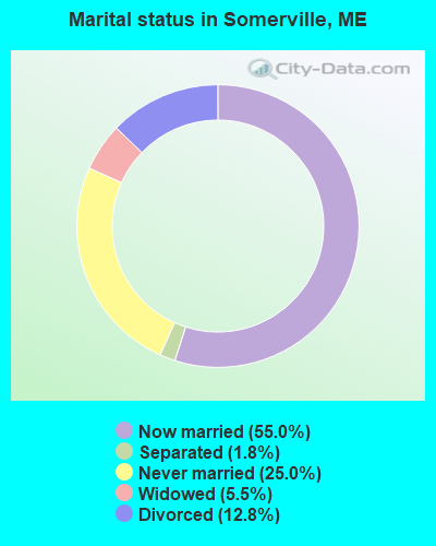
- Never married: 25.0%
- Now married: 55.0%
- Separated: 1.8%
- Widowed: 5.5%
- Divorced: 12.8%
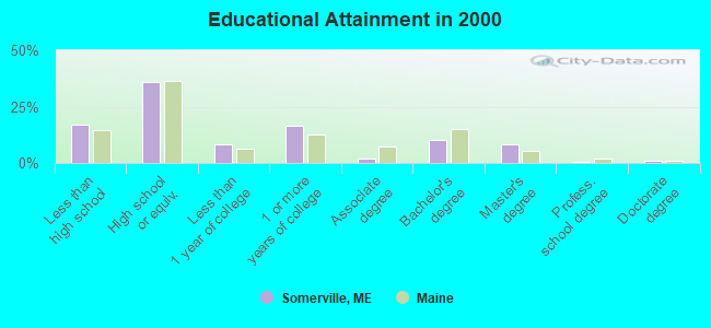
For population 25 years and over in Somerville:
- High school or higher: 82.9%
- Bachelor's degree or higher: 20.2%
- Graduate or professional degree: 10.1%
- Unemployed: 4.2%
- Mean travel time to work (commute): 33.7 minutes

| Here: | 12.6 |
| Maine average: | 11.2 |
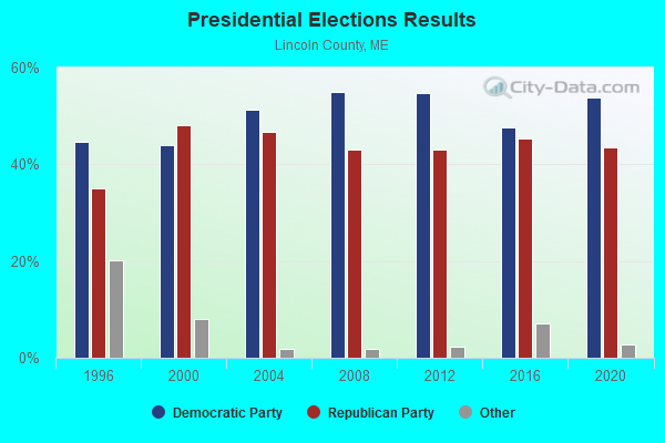
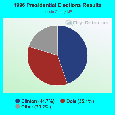
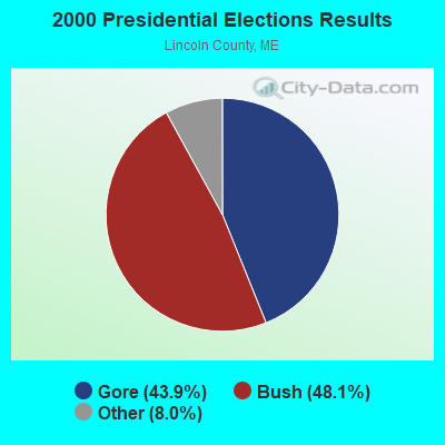


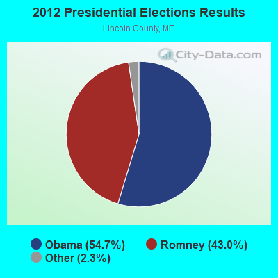

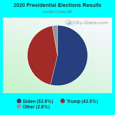
Graphs represent county-level data. Detailed 2008 Election Results
Religion statistics for Somerville, ME (based on Lincoln County data)
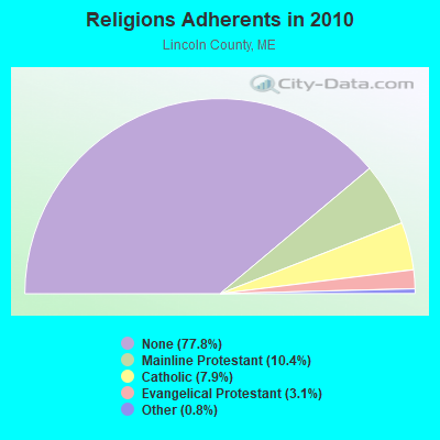

| Religion | Adherents | Congregations |
|---|---|---|
| Mainline Protestant | 3,586 | 29 |
| Catholic | 2,725 | 3 |
| Evangelical Protestant | 1,065 | 12 |
| Other | 279 | 4 |
| None | 26,802 | - |
Food Environment Statistics:
| This county: | 4.03 / 10,000 pop. |
| State: | 2.80 / 10,000 pop. |
| Here: | 2.59 / 10,000 pop. |
| Maine: | 2.20 / 10,000 pop. |
| This county: | 6.62 / 10,000 pop. |
| Maine: | 5.75 / 10,000 pop. |
| Lincoln County: | 13.23 / 10,000 pop. |
| Maine: | 11.02 / 10,000 pop. |
| Lincoln County: | 7.0% |
| Maine: | 8.2% |
| Lincoln County: | 21.9% |
| State: | 25.0% |
Strongest AM radio stations in Somerville:
- WFAU (1280 AM; 5 kW; GARDINER, ME; Owner: CAPSTAR TX LIMITED PARTNERSHIP)
- WSKW (1160 AM; 10 kW; SKOWHEGAN, ME; Owner: MOUNTAIN WIRELESS, INCORPORATED)
- WTME (780 AM; 10 kW; RUMFORD, ME; Owner: MOUNTAIN VALLEY BROADCASTING, INC.)
- WMDR (1340 AM; 1 kW; AUGUSTA, ME; Owner: LIGHT OF LIFE MINISTRIES, INC.)
- WEZW (1400 AM; 1 kW; AUGUSTA, ME; Owner: CITADEL BROADCASTING COMPANY)
- WRKO (680 AM; 50 kW; BOSTON, MA; Owner: ENTERCOM BOSTON LICENSE, LLC)
- WZON (620 AM; 5 kW; BANGOR, ME; Owner: THE ZONE CORPORATION)
- WMTW (870 AM; 10 kW; GORHAM, ME; Owner: RADIO PARTNERS OF MAINE, L.P.)
- WGAN (560 AM; 5 kW; PORTLAND, ME; Owner: SAGA COMMUNICATIONS OF NEW ENGLAND, LLC)
- WABI (910 AM; 5 kW; BANGOR, ME; Owner: CLEAR CHANNEL BROADCASTING LICENSES, INC.)
- WEEI (850 AM; 50 kW; BOSTON, MA; Owner: ENTERCOM BOSTON LICENSE, LLC)
- WLAM (1470 AM; 5 kW; LEWISTON, ME; Owner: RADIO PARTNERS OF MAINE, L.P.)
- WBZ (1030 AM; 50 kW; BOSTON, MA; Owner: INFINITY BROADCASTING OPERATIONS, INC.)
Strongest FM radio stations in Somerville:
- WMEP (90.5 FM; CAMDEN, ME; Owner: MAINE PUBLIC BROADCASTING CORP.)
- WQSS (102.5 FM; CAMDEN, ME; Owner: CLEAR CHANNEL BROADCASTING LICENSES, INC.)
- WMME-FM (92.3 FM; AUGUSTA, ME; Owner: CITADEL BROADCASTING COMPANY)
- WWWA (95.3 FM; WINSLOW, ME; Owner: LIGHT OF LIFE MINISTRIES, INC.)
- WMCM (103.3 FM; ROCKLAND, ME; Owner: CLEAR CHANNEL BROADCASTING LICENSES, INC.)
- WBQX (106.9 FM; THOMASTON, ME; Owner: MARINER BROADCASTING LIMITED PARTNER)
- WWBX (97.1 FM; BANGOR, ME; Owner: CLEAR CHANNEL BROADCASTING LICENSES, INC.)
- WFZX (101.7 FM; SEARSPORT, ME; Owner: CLEAR CHANNEL BROADCASTING LICENSES, INC.)
- WBFB (104.7 FM; BELFAST, ME; Owner: CLEAR CHANNEL BROADCASTING LICENSES, INC.)
- WTOS-FM (105.1 FM; SKOWHEGAN, ME; Owner: CAPSTAR TX LIMITED PARTNERSHIP)
- WCME (96.7 FM; BOOTHBAY HARBOR, ME; Owner: CAPSTAR TX LIMITED PARTNERSHIP)
- WABK-FM (104.3 FM; GARDINER, ME; Owner: CAPSTAR TX LIMITED PARTNERSHIP)
- WMEW (91.3 FM; WATERVILLE, ME; Owner: MAINE PUBLIC BROADCASTING CORPORATION)
- WCYI (93.9 FM; LEWISTON, ME; Owner: CITADEL BROADCASTING COMPANY)
- WKCG (101.3 FM; AUGUSTA, ME; Owner: CAPSTAR TX LIMITED PARTNERSHIP)
- WHQO (107.9 FM; SKOWHEGAN, ME; Owner: MOUNTAIN WIRELESS, INC.)
- WBCI (105.9 FM; BATH, ME; Owner: BLOUNT COMMUNICATIONS, INC.)
- WCTB (93.5 FM; FAIRFIELD, ME; Owner: MOUNTAIN WIRELESS, INC.)
- WEBB (98.5 FM; WATERVILLE, ME; Owner: CITADEL BROADCASTING COMPANY)
TV broadcast stations around Somerville:
- WPFO (Channel 23; WATERVILLE, ME; Owner: CMCG PORTLAND LICENSE LLC)
- WGME-TV (Channel 13; PORTLAND, ME; Owner: WGME LICENSEE, LLC)
- WCBB (Channel 10; AUGUSTA, ME; Owner: MAINE PUBLIC BROADCASTING CORP.)
- WFYW-LP (Channel 69; FAIRFIELD/WATERVILLE, ME; Owner: THREE ANGELS BROADCASTING NETWORK, INC.)
- DW23AB (Channel 23; WATERVILLE, ME; Owner: RUSSELL COMMUNICATIONS)
Somerville fatal accident list:
Jun 14, 2012 11:43 PM, Sr-105, Lat: 44.311114, Lon: -69.473875, Vehicles: 1, Persons: 1, Fatalities: 1
Mar 2, 2004 11:00 PM, Sr-17, Vehicles: 1, Persons: 2, Fatalities: 1
Feb 14, 1987 05:50 PM, 14041406, Vehicles: 1, Persons: 3, Fatalities: 1, Drunk persons involved: 1
- National Bridge Inventory (NBI) Statistics
- 2Number of bridges
- 10ft / 2.6mTotal length
- 851Total average daily traffic
- 42Total average daily truck traffic
- 1,362Total future (year 2036) average daily traffic
FCC Registered Amateur Radio Licenses:
4- Call Sign: KB1DFX, Licensee ID: L01587677, Grant Date: 08/14/2020, Expiration Date: 08/14/2030, Certifier: David E Stanley, Registrant: David E Stanley, 599 Crummett Mtn Rd, Somerville, ME 04348
- Call Sign: KB2EYX, Licensee ID: L00845642, Grant Date: 01/13/1998, Expiration Date: 01/13/2008, Cancellation Date: 01/14/2010, Registrant: Robert L Scherlacher, 3348 Turner Ridge Road, Somerville, ME 04348-3015
- Call Sign: KB1IJH, Licensee ID: L00516856, Grant Date: 05/18/2012, Expiration Date: 05/18/2022, Certifier: Michelle A Hisler, Registrant: Michelle A Hisler, 12 Brann Rd, Somerville, ME 04348
- Call Sign: KB1IJI, Licensee ID: L00516857, Grant Date: 05/18/2012, Expiration Date: 05/18/2022, Certifier: Martin D Hisler, Registrant: Martin D Hisler, 12 Brann Rd, Somerville, ME 04348
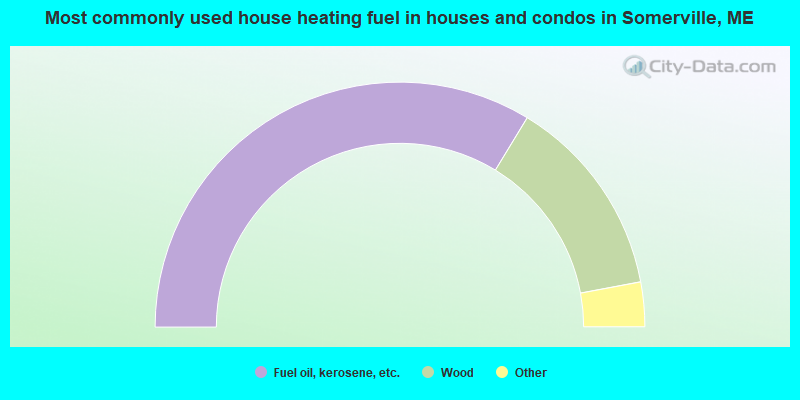
- 67.4%Fuel oil, kerosene, etc.
- 26.7%Wood
- 3.7%Bottled, tank, or LP gas
- 2.1%Electricity
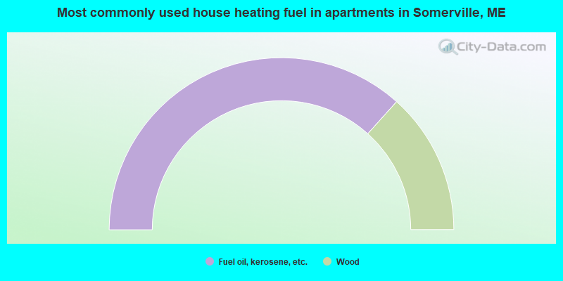
- 73.3%Fuel oil, kerosene, etc.
- 26.7%Wood
Somerville compared to Maine state average:
- Unemployed percentage significantly below state average.
- Black race population percentage significantly below state average.
- Foreign-born population percentage below state average.
- Renting percentage significantly below state average.
- Length of stay since moving in significantly above state average.
- Number of rooms per house significantly below state average.
- House age significantly below state average.

|
Total of 5 patent applications in 2008-2024.