According to our research of New York and other state lists, there was 1 registered sex offender living in Katonah, New York as of April 28, 2024. The ratio of all residents to sex offenders in Katonah is 2,088 to 1. The ratio of registered sex offenders to all residents in this city is lower than the state average.
Recent articles from our blog. Our writers, many of them Ph.D. graduates or candidates, create easy-to-read articles on a wide variety of topics.
Ancestries: Italian (17.6%), Eastern European (16.7%), Irish (9.2%), German (8.2%), European (6.1%), American (5.1%).
Current Local Time: EST time zone
Elevation: 226 feet
243 residents are foreign born (6.2% Asia, 4.4% Europe, 2.3% Latin America).
This place:
12.9%
New York:
22.6%
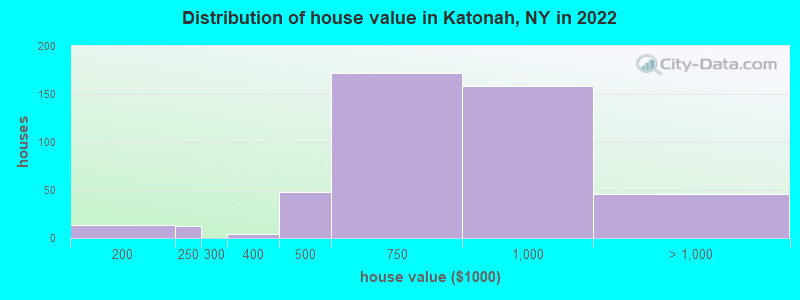
Median real estate property taxes paid for housing units with mortgages in 2022: $10,001 (1.2%) Median real estate property taxes paid for housing units with no mortgage in 2022: $10,001 (1.6%)
Nearest city with pop. 50,000+: Stamford, CT (14.8 miles , pop. 117,083).
Nearest city with pop. 200,000+: Bronx, NY (30.1 miles , pop. 1,332,650).
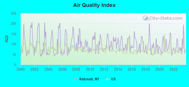
Air Quality Index (AQI) level in 2023 was 95.4. This is worse than average.
City:
95.4
U.S.:
72.6
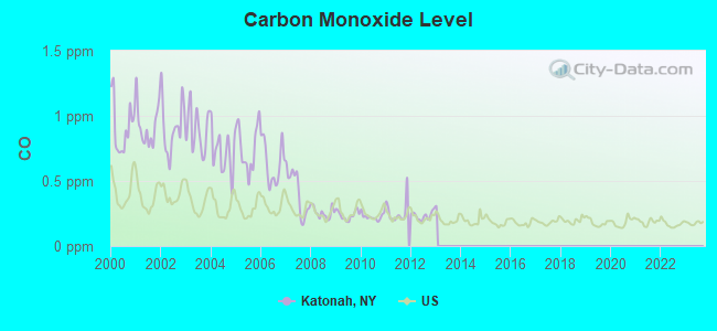
Carbon Monoxide (CO) [ppm] level in 2012 was 0.234. This is about average.Closest monitor was 15.8 miles away from the city center.
City:
0.234
U.S.:
0.251
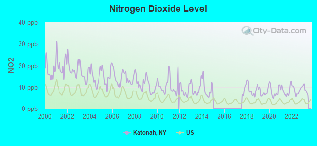
Nitrogen Dioxide (NO2) [ppb] level in 2022 was 8.39. This is significantly worse than average.Closest monitor was 12.4 miles away from the city center.
City:
8.39
U.S.:
5.11
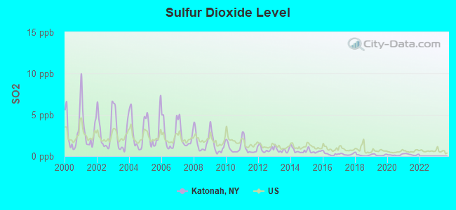
Sulfur Dioxide (SO2) [ppb] level in 2021 was 0.196. This is significantly better than average.Closest monitor was 3.8 miles away from the city center.
City:
0.196
U.S.:
1.515
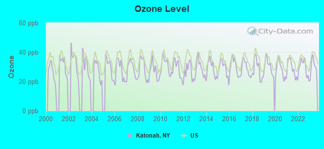
Ozone [ppb] level in 2023 was 30.3. This is about average.Closest monitor was 12.4 miles away from the city center.
City:
30.3
U.S.:
33.3
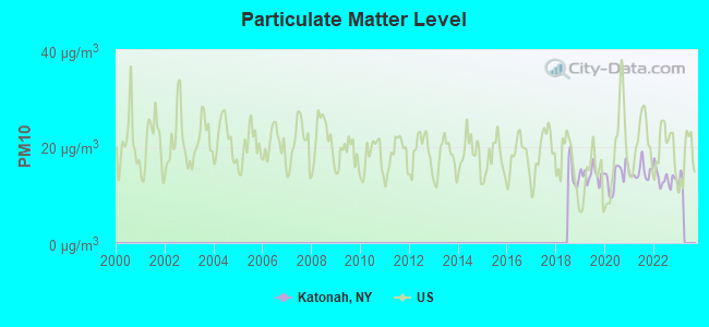
Particulate Matter (PM10) [µg/m3] level in 2022 was 13.5. This is significantly better than average.Closest monitor was 11.3 miles away from the city center.
City:
13.5
U.S.:
19.2
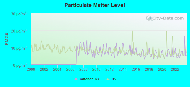
Particulate Matter (PM2.5) [µg/m3] level in 2023 was 7.53. This is about average.Closest monitor was 15.8 miles away from the city center.
City:
7.53
U.S.:
8.11
Tornado activity:
Katonah-area historical tornado activity is above New York state average. It is 34% smaller than the overall U.S. average.
On 7/10/1989, a category F4 (max. wind speeds 207-260 mph) tornado 40.0 miles away from the Katonah place center injured 40 peopleand causedbetween $50,000,000 and $500,000,000 in damages.
On 5/24/1962, a category F3 (max. wind speeds 158-206 mph) tornado 35.6 miles away from the place center killed one personand injured 50 peopleand causedbetween $500,000 and $5,000,000 in damages.
Earthquake activity:
Katonah-area historical earthquake activity is significantly above New York state average. It is 69% smaller than the overall U.S. average.
On 10/7/1983 at 10:18:46, a magnitude 5.3 (5.1 MB, 5.3 LG, 5.1 ML, Class: Moderate, Intensity: VI - VII) earthquake occurred 189.3 miles away from Katonah center On 4/20/2002 at 10:50:47, a magnitude 5.3 (5.3 ML, Depth: 3.0 mi) earthquake occurred 225.0 miles away from Katonah center On 8/23/2011 at 17:51:04, a magnitude 5.8 (5.8 MW, Depth: 3.7 mi) earthquake occurred 324.0 miles away from the city center On 4/20/2002 at 10:50:47, a magnitude 5.2 (5.2 MB, 4.2 MS, 5.2 MW, 5.0 MW) earthquake occurred 223.3 miles away from the city center On 1/16/1994 at 01:49:16, a magnitude 4.6 (4.6 MB, 4.6 LG, Depth: 3.1 mi, Class: Light, Intensity: IV - V) earthquake occurred 138.9 miles away from the city center On 1/19/1982 at 00:14:42, a magnitude 4.7 (4.5 MB, 4.7 MD, 4.5 LG) earthquake occurred 188.1 miles away from the city center Magnitude types: regional Lg-wave magnitude (LG), body-wave magnitude (MB), duration magnitude (MD), local magnitude (ML), surface-wave magnitude (MS), moment magnitude (MW)
Natural disasters:
The number of natural disasters in Westchester County (26) is a lot greater than the US average (15). Major Disasters (Presidential) Declared: 17 Emergencies Declared: 8
Causes of natural disasters: Floods: 9, Storms: 9, Hurricanes: 7, Blizzards: 2, Heavy Rains: 2, Tropical Storms: 2, Landslide: 1, Power Outage: 1, Snowstorm: 1, Water Shortage: 1, Other: 3 (Note: some incidents may be assigned to more than one category).
Hospitals and medical centers in Katonah:
FOUR WINDS (provides emergency services, 800 CROSS RIVER RD)
Other hospitals and medical centers near Katonah:
COMMUNITY BASED SERVICES, INC (Hospital, about 3 miles away; GOLDENS BRIDGE, NY)
DATAHR (Home Health Center, about 4 miles away; MOUNT KISCO, NY)
SWISS HOME HEALTH RELATED FACILITY (Nursing Home, about 4 miles away; MOUNT KISCO, NY)
NORTHERN WESTCHESTER HOSPITAL Acute Care Hospitals (about 5 miles away; MOUNT KISCO, NY)
WATERVIEW HILLS REHABILITATION AND NRSG CTR (Nursing Home, about 6 miles away; PURDY STATION, NY)
SALEM HILLS REHABILITATION AND NURSING CTR (Nursing Home, about 6 miles away; PURDYS, NY)
OPENGATE, INC (Hospital, about 6 miles away; SOMERS, NY)
Amtrak stations near Katonah:
12 miles: CROTON-HARMON (CROTON-ON-HUDSON, CROTON POINT AVE.) . Services: partially wheelchair accessible, enclosed waiting area, public restrooms, public payphones, snack bar, paid short-term parking, paid long-term parking, call for car rental service, call for taxi service, public transit connection.
17 miles: STAMFORD (WASHINGTON BLVD. & E. STATE ST.) . Services: ticket office, fully wheelchair accessible, enclosed waiting area, public restrooms, public payphones, snack bar, ATM, paid short-term parking, paid long-term parking, call for car rental service, taxi stand, public transit connection.
Operable nuclear power plants near Katonah:
14 miles: Indian Point 2 and 3 in Buchanan, NY.
Colleges/universities with over 2000 students nearest to Katonah:
SUNY Westchester Community College (about 15 miles; Valhalla, NY; Full-time enrollment: 10,278)
SUNY at Purchase College (about 15 miles; Purchase, NY; FT enrollment: 4,415)
Manhattanville College (about 16 miles; Purchase, NY; FT enrollment: 2,299)
Western Connecticut State University (about 16 miles; Danbury, CT; FT enrollment: 5,345)
Norwalk Community College (about 17 miles; Norwalk, CT; FT enrollment: 4,085)
United States Military Academy (about 17 miles; West Point, NY; FT enrollment: 5,651)
Nyack College (about 18 miles; Nyack, NY; FT enrollment: 2,590)
Private high school in Katonah:
THE HARVEY SCHOOL(Students: 336, Location: 260 JAY ST, Grades: 6-12)
Public elementary/middle school in Katonah:
KATONAH ELEMENTARY SCHOOL (Location: 106 HUNTVILLE RD, Grades: KG-5)
Churches in Katonah include: Saint Lukes Episcopal Church (A), First Presbyterian Church (B), First Church of Christ Scientist (C), Katonah United Methodist Church (D). Display/hide their locations on the map
Birthplace of: Donnie McGrath - College basketball player (Providence Friars), Joseph Breen - (born 1958), soap opera actor.
Westchester County has a predicted average indoor radon screening level less than 2 pCi/L (pico curies per liter) - Low Potential
Drinking water stations with addresses in Katonah and their reported violations in the past:
LE FONTANE (ALFANT CORP) (Address: 137 ROUTE 100 (-Rt 139) , Population served: 101, Groundwater):
Past monitoring violations:
2 routine major monitoring violations
3 regular monitoring violations
JOHN JAY HOMESTEAD (Population served: 100, Groundwater under infl of surface water):
Past monitoring violations:
2 routine major monitoring violations
4 regular monitoring violations
NYS DOT RESIDENCY- KATONAH (Population served: 30, Groundwater under infl of surface water):
Past health violations:
Treatment Technique (SWTR and GWR) - In AUG-2013. Follow-up actions: St Formal NOV issued (AUG-08-2013), St Public Notif requested (AUG-08-2013)
Failure to Filter (SWTR) - In FEB-27-2007. Follow-up actions: St Formal NOV issued (MAR-02-2007), St Tech Assistance Visit (MAY-21-2007), St Compliance achieved (MAR-06-2008)
Past monitoring violations:
3 routine major monitoring violations
2 regular monitoring violations
KELLY PROPERTIES (Population served: 25, Groundwater):
Past health violations:
MCL, Monthly (TCR) - Between OCT-2007 and DEC-2007, Contaminant: Coliform. Follow-up actions: St Public Notif requested (NOV-26-2007), St Compliance achieved (NOV-26-2007), St Boil Water Order (NOV-26-2007)
Past monitoring violations:
One routine major monitoring violation
Drinking water stations with addresses in Katonah that have no violations reported:
MUSCOOT RESTAURANT (Population served: 120,Primary Water Source Type: Groundwater)
JOHN JAY FIELD HOUSE (Population served: 100,Primary Water Source Type: Groundwater)
PATTERSON PROFESSIONAL OFFICE (Address: 282 Katonah Avenue # 148 , Population served: 30,Primary Water Source Type: Groundwater)
Average household size:
This place:
2.8 people
New York:
2.6 people
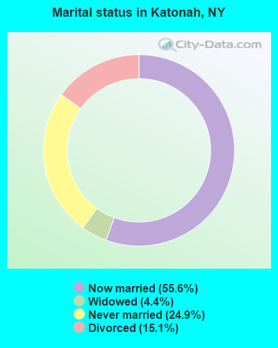
Percentage of family households:
This place:
75.6%
Whole state:
63.5%
Percentage of households with unmarried partners:
This place:
5.6%
Whole state:
6.8%
Likely homosexual households (counted as self-reported same-sex unmarried-partner households)
Lesbian couples: 1.0% of all households
Gay men: 0.2% of all households
9 people in group homes intended for adults in 2010
3 people in other noninstitutional facilities in 2010
Banks with branches in Katonah (2011 data):
Wells Fargo Bank, National Association: Katonah Branch at 262 Katonah Avenue, branch established on 1971/12/18. Info updated 2011/04/05: Bank assets: $1,161,490.0 mil, Deposits: $905,653.0 mil, headquarters in Sioux Falls, SD, positive income, 6395 total offices, Holding Company: Wells Fargo & Company
Bank of America, National Association: Katonah Branch at 256 Katonah Avenue, branch established on 1963/09/03. Info updated 2009/11/18: Bank assets: $1,451,969.3 mil, Deposits: $1,077,176.8 mil, headquarters in Charlotte, NC, positive income, 5782 total offices, Holding Company: Bank Of America Corporation
JPMorgan Chase Bank, National Association: Katonah Branch at 140 Katonah Avenue, branch established on 1955/01/31. Info updated 2011/11/10: Bank assets: $1,811,678.0 mil, Deposits: $1,190,738.0 mil, headquarters in Columbus, OH, positive income, International Specialization, 5577 total offices, Holding Company: Jpmorgan Chase & Co.
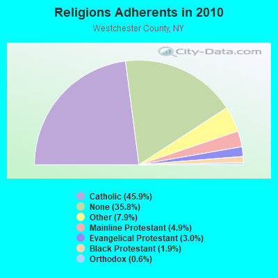
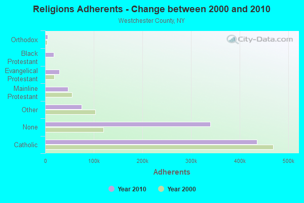
Religion statistics for Katonah, NY (based on Westchester County data)
Religion
Adherents
Congregations
Catholic
435,590
100
Other
75,029
114
Mainline Protestant
46,854
176
Evangelical Protestant
28,915
209
Black Protestant
17,814
38
Orthodox
5,458
16
None
339,453
-
Source: Clifford Grammich, Kirk Hadaway, Richard Houseal, Dale E.Jones, Alexei Krindatch, Richie Stanley and Richard H.Taylor. 2012. 2010 U.S.Religion Census: Religious Congregations & Membership Study. Association of Statisticians of American Religious Bodies. Jones, Dale E., et al. 2002. Congregations and Membership in the United States 2000. Nashville, TN: Glenmary Research Center. Graphs represent county-level data
Food Environment Statistics:
Number of grocery stores: 417
Here:
4.39 / 10,000 pop.
New York:
4.13 / 10,000 pop.
Number of supercenters and club stores: 5
Westchester County:
0.05 / 10,000 pop.
New York:
0.06 / 10,000 pop.
Number of convenience stores (no gas): 71
This county:
0.75 / 10,000 pop.
State:
0.92 / 10,000 pop.
Number of convenience stores (with gas): 111
Westchester County:
1.17 / 10,000 pop.
New York:
1.68 / 10,000 pop.
Number of full-service restaurants: 904
This county:
9.52 / 10,000 pop.
State:
8.82 / 10,000 pop.
Adult diabetes rate:
Westchester County:
7.6%
New York:
8.2%
Adult obesity rate:
Westchester County:
19.1%
State:
23.8%
Low-income preschool obesity rate:
This county:
17.8%
New York:
15.6%
5.69% of this county's 2021 resident taxpayers lived in other counties in 2020 ($147,956 average adjusted gross income)
Here:
5.69%
New York average:
5.29%
0.02% of residents moved from foreign countries ($25 average AGI)
Westchester County:
0.02%
New York average:
0.01%
Top counties from which taxpayers relocated into this county between 2020 and 2021:
1 Pepsi Way (Lat: 41.275278 Lon: -73.701389), Type: Mast, Structure height: 22.9 m, Overall height: 33.5 m, Call Sign: KEC625, Assigned Frequencies: 154.220 MHz, Grant Date: 11/23/2021, Expiration Date: 02/20/2032, Certifier: Steven D Dunn, Registrant: Somers Fire District, 122 Baltimore St, West Caldwell, NJ 07007, Phone: (877) 359-5350, Fax: (201) 488-1690, Email:
John Jay Homestead 3 Mi S I84 On Rt 22 (Lat: 41.251472 Lon: -73.652083), Type: Pole, Structure height: 9 m, Call Sign: WBN997, Licensee ID: L00002981, Assigned Frequencies: 153.785 MHz, Grant Date: 11/06/2014, Expiration Date: 02/01/2025, Registrant: New York State Office Of Parks, Recreation, And Historic Preservation (Oprhp) - Taconic, 6105 E. Seneca Turnpike, Jamesville, NY 13078, Phone: (315) 498-9027, Fax: (315) 498-9219, Email:
93-KATONAH, Mta Rail Station-Katonah (Lat: 41.259444 Lon: -73.693611), Type: Bant, Structure height: 15.3 m, Call Sign: WQEC220, Assigned Frequencies: 851.037 MHz, 851.537 MHz, 852.037 MHz, 852.537 MHz, 853.037 MHz, Grant Date: 12/27/2005, Expiration Date: 12/27/2015, Cancellation Date: 01/14/2011, Certifier: Thomas J Cowper, Registrant: Nys Dhses Office Of Interoperable And Emergency Communications, State Office Campus Building 22, 1220 Washington Ave, Albany, NY 12226, Phone: (518) 322-4912, Fax: (518) 322-4975, Email:
KATONAH 221 FD, 65 Bedford Road (Lat: 41.255361 Lon: -73.685028), Type: Bant, Structure height: 13.6 m, Overall height: 19.7 m, Call Sign: WQGX405, Assigned Frequencies: 473.325 MHz, 473.350 MHz, 473.375 MHz, 473.525 MHz, 473.550 MHz, 473.575 MHz, Grant Date: 03/02/2017, Expiration Date: 05/14/2027, Certifier: Thomas R Raffaelli, Registrant: County Of Westchester, 148 Martine Avenue, Rm B-18-B, White Plains, NY 10601, Phone: (914) 995-6375, Email:
Lat: 41.232278 Lon: -73.652583, Call Sign: WQYN264, Assigned Frequencies: 461.125 MHz, 466.125 MHz, 467.275 MHz, 468.825 MHz, 469.600 MHz, Grant Date: 11/15/2016, Expiration Date: 11/15/2026, Certifier: Larry Reid, Registrant: Two Way Direct, 3262 Grey Hawk Court, Carlsbad, CA 92010, Phone: (888) 742-5893, Email:
FCC Registered Microwave Towers:
5
KATONAH A, Lat: 41.276556 Lon: -73.687028, Type: Pole, Structure height: 16.8 m, Call Sign: WQSG754, Assigned Frequencies: 3650.00 MHz, Grant Date: 09/18/2013, Expiration Date: 09/18/2023, Cancellation Date: 10/19/2022, Certifier: Scott Mahoney, Registrant: Lerman Senter Pllc, 2001 L Street, Nw, Suite 400, Washington, DC 20036, Phone: (202) 416-6749, Fax: (202) 293-7783, Email:
KATONAH B, Lat: 41.276556 Lon: -73.687028, Type: Pole, Structure height: 16.8 m, Call Sign: WQSG754, Assigned Frequencies: 3650.00 MHz, Grant Date: 09/18/2013, Expiration Date: 09/18/2023, Cancellation Date: 10/19/2022, Certifier: Scott Mahoney, Registrant: Lerman Senter Pllc, 2001 L Street, Nw, Suite 400, Washington, DC 20036, Phone: (202) 416-6749, Fax: (202) 293-7783, Email:
KATONAH C, Lat: 41.276556 Lon: -73.687028, Type: Pole, Structure height: 16.8 m, Call Sign: WQSG754, Assigned Frequencies: 3650.00 MHz, Grant Date: 09/18/2013, Expiration Date: 09/18/2023, Cancellation Date: 10/19/2022, Certifier: Scott Mahoney, Registrant: Lerman Senter Pllc, 2001 L Street, Nw, Suite 400, Washington, DC 20036, Phone: (202) 416-6749, Fax: (202) 293-7783, Email:
KATONAH D, Lat: 41.276556 Lon: -73.687028, Type: Pole, Structure height: 16.8 m, Call Sign: WQSG754, Assigned Frequencies: 3650.00 MHz, Grant Date: 09/18/2013, Expiration Date: 09/18/2023, Cancellation Date: 10/19/2022, Certifier: Scott Mahoney, Registrant: Lerman Senter Pllc, 2001 L Street, Nw, Suite 400, Washington, DC 20036, Phone: (202) 416-6749, Fax: (202) 293-7783, Email:
Maho SO, Lat: 41.276556 Lon: -73.687028, Type: Pole, Structure height: 16.8 m, Call Sign: WQSG754, Assigned Frequencies: 3650.00 MHz, Grant Date: 09/18/2013, Expiration Date: 09/18/2023, Cancellation Date: 10/19/2022, Certifier: Scott Mahoney, Registrant: Lerman Senter Pllc, 2001 L Street, Nw, Suite 400, Washington, DC 20036, Phone: (202) 416-6749, Fax: (202) 293-7783, Email:
Aircraft: PIPER PA-28-180 (Category: Land, Seats: 4, Weight: Up to 12,499 Pounds, Speed: 107 mph), Engine: LYCOMING O&VO-360 SER (180 HP) (Reciprocating) N-Number: 15626, N15626, N-15626, Serial Number: 28-7305138, Year manufactured: 1972, Airworthiness Date: 12/05/1972, Certificate Issue Date: 02/10/2003 Registrant (Co-Owned): Frank M Peretta, 5 Hickory Rd, Katonah, NY 10536, Other Owners: Linda A Peretta
Aircraft: HELIO H-391B (Category: Land, Seats: 4, Weight: Up to 12,499 Pounds, Speed: 117 mph), Engine: LYCOMING GO-435C&D SER (260 HP) (Reciprocating) N-Number: 4120D, N4120D, N-4120D, Serial Number: 044, Year manufactured: 1957, Airworthiness Date: 06/07/1957, Certificate Issue Date: 12/20/1990 Registrant (Individual): Leslie H Mccurdy, 140 Cedar Rd, Katonah, NY 10536
Aircraft: LEARJET INC 60 (Category: Land, Engines: 2, Seats: 11, Weight: Up to 12,499 Pounds), Engine: P&W CANADA 305 SERIES (5200 HP) (Turbo-fan) N-Number: 44RM, N44RM, N-44RM, Serial Number: 004, Year manufactured: 1993, Airworthiness Date: 06/08/2001, Certificate Issue Date: 03/17/2010 Registrant (LLC): Flat Rock Associates Ii LLC, 369 Mt Holly Rd, Katonah, NY 10536
Aircraft: CESSNA 172G (Category: Land, Seats: 4, Weight: Up to 12,499 Pounds, Speed: 105 mph), Engine: CONT MOTOR 0-300 SER (145 HP) (Reciprocating) N-Number: 4600L, N4600L, N-4600L, Serial Number: 17254595, Airworthiness Date: 05/10/1966, Certificate Issue Date: 03/25/2019 Registrant (Individual): Edwin J Ritchie, 4 Lakeview Dr, Katonah, NY 10536 Deregistered:Cancel Date: 06/26/2018
Aircraft: BEECH C23 (Category: Land, Seats: 4, Weight: Up to 12,499 Pounds, Speed: 116 mph), Engine: AMA/EXPR UNKNOWN ENG (Reciprocating) N-Number: 6528N, N6528N, N-6528N, Serial Number: M-2366, Year manufactured: 1982, Airworthiness Date: 08/19/1982, Certificate Issue Date: 12/01/1997 Registrant (Individual): John A Morgan, 7 Macauley Rd, Katonah, NY 10536
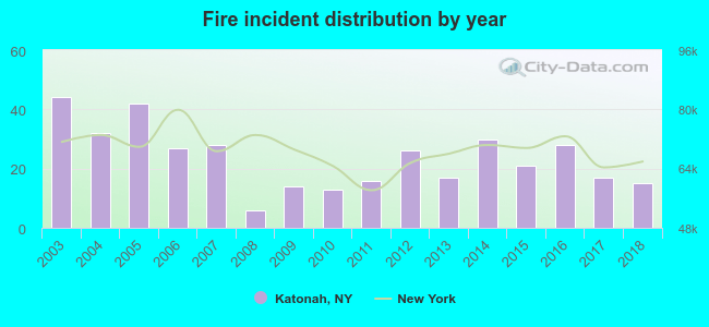
2003 - 2018 National Fire Incident Reporting System (NFIRS) incidents
Based on the data from the years 2003 - 2018 the average number of fire incidents per year is 24. The highest number of reported fires - 44 took place in 2003, and the least - 6 in 2008. The data has a declining trend.
When looking into fire subcategories, the most incidents belonged to: Structure Fires (35.9%), and Outside Fires (25.3%).
Fire incident types reported to NFIRS in Katonah, NY


 Recent articles from our blog. Our writers, many of them Ph.D. graduates or candidates, create easy-to-read articles on a wide variety of topics.
 (14.8 miles
 Based on the data from the years 2003 - 2018 the average number of fire incidents per year is 24. The highest number of reported fires - 44 took place in 2003, and the least - 6 in 2008. The data has a declining trend.
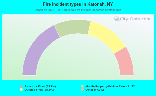 When looking into fire subcategories, the most incidents belonged to: Structure Fires (35.9%), and Outside Fires (25.3%).