Lanier, Tennessee
Submit your own pictures of this place and show them to the world
- OSM Map
- General Map
- Google Map
- MSN Map

| Males: 5,673 | |
| Females: 5,861 |
| Median resident age: | 38.2 years |
| Tennessee median age: | 35.9 years |
Zip code: 37803
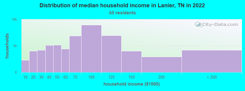
| Lanier: | $73,529 |
| TN: | $65,254 |
Estimated per capita income in 2022: $37,162 (it was $19,225 in 2000)
Lanier CCD income, earnings, and wages data
Estimated median house or condo value in 2022: $323,416 (it was $102,500 in 2000)
| Lanier: | $323,416 |
| TN: | $284,800 |
Mean prices in 2022: all housing units: $370,238; detached houses: $400,839; townhouses or other attached units: $355,800; in 2-unit structures: $229,423; in 3-to-4-unit structures: $294,641; in 5-or-more-unit structures: $270,866; mobile homes: $109,553; occupied boats, rvs, vans, etc.: $46,301
Detailed information about poverty and poor residents in Lanier, TN
Compare current foreclosures near Lanier, TN:
| Photo | Address | Area | Beds / Baths | Price | Details |
|---|---|---|---|---|---|

|
#1
Old Niles Ferry Pike
Greenback, TN 37742
|
1,689 sq. feet
|
2 baths 3 beds |
show details | |

|
#2
Willow View Ln
Knoxville, TN 37922
|
1,742 sq. feet
|
3 baths 4 beds |
show details | |

|
#3
Grenada Blvd
Knoxville, TN 37922
|
2,508 sq. feet
|
2 baths 3 beds |
show details | |

|
#4
Sedgewick Dr
Knoxville, TN 37922
|
2,004 sq. feet
|
2 baths 3 beds |
show details | |

|
#5
E Coast Tellico Pkwy
Greenback, TN 37742
|
2,816 sq. feet
|
2 baths - beds |
show details | |

|
#6
Grenada Blvd
Knoxville, TN 37922
|
2,086 sq. feet
|
2 baths 3 beds |
show details | |

|
#7
Harts View Dr
Knoxville, TN 37922
|
1,092 sq. feet
|
2 baths 3 beds |
show details | |

|
#8
Poplar Glen Dr
Knoxville, TN 37922
|
3,957 sq. feet
|
5 baths 4 beds |
show details | |

|
#9
W Howe St
Alcoa, TN 37701
|
851 sq. feet
|
1 baths - beds |
show details | |

|
#10
Bessie Harvey Ave
Alcoa, TN 37701
|
2,268 sq. feet
|
1 baths - beds |
show details |
| Photo | Address | Area | Beds / Baths | Price | Details |
|---|---|---|---|---|---|

|
#11
Pineview Rd
Maryville, TN 37803
|
1,960 sq. feet
|
1 baths - beds |
show details | |

|
#12
W Old Topside Rd
Louisville, TN 37777
|
1,944 sq. feet
|
2 baths - beds |
show details | |

|
#13
Woodlawn Ave
Maryville, TN 37804
|
1,912 sq. feet
|
1 baths - beds |
show details | |

|
#14
Glascock St
Alcoa, TN 37701
|
1,401 sq. feet
|
2 baths - beds |
show details | |

|
#15
Martin St
Maryville, TN 37804
|
1,286 sq. feet
|
1 baths - beds |
show details | |

|
#16
W Stephenson St
Alcoa, TN 37701
|
993 sq. feet
|
2 baths - beds |
show details | |

|
#17
W Newcomen St
Alcoa, TN 37701
|
1,272 sq. feet
|
2 baths - beds |
show details | |

|
#18
W Fulton St
Alcoa, TN 37701
|
608 sq. feet
|
1 baths - beds |
show details | |

|
#19
Sevierville Rd
Maryville, TN 37804
|
2,286 sq. feet
|
2 baths - beds |
show details | |

|
#20
Topside Rd
Louisville, TN 37777
|
816 sq. feet
|
1 baths - beds |
show details |
| Photo | Address | Area | Beds / Baths | Price | Details |
|---|---|---|---|---|---|

|
#21
Finn Long Rd
Friendsville, TN 37737
|
1,194 sq. feet
|
1 baths - beds |
show details | |

|
#22
Sams Rd
Rockford, TN 37853
|
866 sq. feet
|
1 baths - beds |
show details | |

|
#23
Gigi Ln
Loudon, TN 37774
|
1,534 sq. feet
|
2 baths - beds |
show details | |

|
#24
Mcnabb Pl
Maryville, TN 37801
|
960 sq. feet
|
1 baths - beds |
show details | |

|
#25
Pea Ridge Rd
Maryville, TN 37804
|
2,950 sq. feet
|
3 baths - beds |
show details | |

|
#26
Belle St
Maryville, TN 37803
|
969 sq. feet
|
1 baths - beds |
show details | |

|
#27
Chestnut Valley Rd
Vonore, TN 37885
|
864 sq. feet
|
1 baths - beds |
show details | |

|
#28
Timberview Ct
Maryville, TN 37801
|
1,227 sq. feet
|
2 baths - beds |
show details | |

|
#29
Manchester Dr
Maryville, TN 37803
|
2,044 sq. feet
|
2 baths - beds |
show details | |

|
#30
Promontory Pt
Louisville, TN 37777
|
4,183 sq. feet
|
4 baths - beds |
show details |
| Photo | Address | Area | Beds / Baths | Price | Details |
|---|---|---|---|---|---|

|
#31
Grove St
Maryville, TN 37804
|
736 sq. feet
|
1 baths - beds |
show details | |

|
#32
Maple Hill Rd
Loudon, TN 37774
|
3,420 sq. feet
|
2 baths - beds |
show details | |

|
#33
Broyles Ave
Maryville, TN 37801
|
896 sq. feet
|
1 baths - beds |
show details | |

|
#34
W Stephenson St
Alcoa, TN 37701
|
714 sq. feet
|
1 baths - beds |
show details | |

|
#35
Glenn Rd
Louisville, TN 37777
|
1,612 sq. feet
|
2 baths - beds |
show details | |

|
#36
Irwin Ave
Maryville, TN 37804
|
2,220 sq. feet
|
1 baths - beds |
show details | |

|
#37
Gateway Rd
Maryville, TN 37804
|
1,338 sq. feet
|
2 baths - beds |
show details | |

|
#38
Fletcher St
Maryville, TN 37804
|
736 sq. feet
|
1 baths - beds |
show details | |

|
#39
Henderson St
Maryville, TN 37804
|
1,120 sq. feet
|
2 baths - beds |
show details | |

|
#40
Ford St
Alcoa, TN 37701
|
1,248 sq. feet
|
1 baths - beds |
show details |
| Photo | Address | Area | Beds / Baths | Price | Details |
|---|---|---|---|---|---|

|
#41
Glenfield Cir
Maryville, TN 37804
|
1,572 sq. feet
|
2 baths - beds |
show details | |

|
#42
Orton Dr
Maryville, TN 37804
|
1,070 sq. feet
|
1 baths - beds |
show details | |

|
#43
Mackenzie Dr
Maryville, TN 37804
|
1,770 sq. feet
|
2 baths - beds |
show details | |

|
#44
Druid Hill Dr
Maryville, TN 37804
|
1,352 sq. feet
|
2 baths - beds |
show details | |

|
#45
E Hunt Rd
Alcoa, TN 37701
|
1,207 sq. feet
|
1 baths - beds |
show details | |

|
#46
Highway 360
Vonore, TN 37885
|
576 sq. feet
|
1 baths - beds |
show details | |

|
#47
Benson Ln
Friendsville, TN 37737
|
1,216 sq. feet
|
1 baths - beds |
show details | |

|
#48
Tarpley St
Maryville, TN 37804
|
1,590 sq. feet
|
2 baths - beds |
show details | |

|
#49
Arthur Ave
Maryville, TN 37804
|
836 sq. feet
|
1 baths - beds |
show details | |

|
Check over 1 million property listings on Foreclosure.com!
|
browse all offers | |||

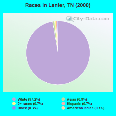
- 9,94097.2%White alone
- 890.9%Asian alone
- 750.7%Two or more races
- 690.7%Hispanic
- 350.3%Black alone
- 120.1%American Indian alone
- 20.02%Native Hawaiian and Other
Pacific Islander alone - 20.02%Other race alone
Races in Lanier detailed stats: ancestries, foreign born residents, place of birth
 Recent articles from our blog. Our writers, many of them Ph.D. graduates or candidates, create easy-to-read articles on a wide variety of topics.
Current Local Time: EST time zone
Elevation: 980 feet
Land area: 140.6 square miles.
Population density: 82 people per square mile (very low).

| Lanier CCD: | 0.6% ($566) |
| Tennessee: | 0.8% ($715) |
Nearest city with pop. 50,000+: Knoxville, TN  (24.2 miles , pop. 173,890).
Nearest city with pop. 200,000+: Atlanta, GA (131.1 miles , pop. 416,474).
Nearest city with pop. 1,000,000+: Chicago, IL (472.4 miles , pop. 2,896,016).
Nearest cities:
), ), ), ), Latitude: 35.63 N, Longitude: 84.03 W
Area code commonly used in this area: 865

| Here: | 2.7% |
| Tennessee: | 3.0% |
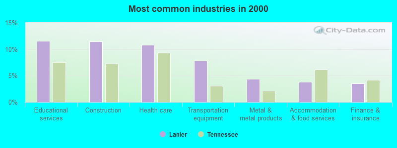
- Educational services (11.5%)
- Construction (11.4%)
- Health care (10.8%)
- Transportation equipment (7.8%)
- Metal & metal products (4.4%)
- Accommodation & food services (3.9%)
- Finance & insurance (3.5%)
- Construction (18.0%)
- Transportation equipment (9.5%)
- Metal & metal products (7.6%)
- Educational services (5.7%)
- Motor vehicle & parts dealers (4.1%)
- Truck transportation (3.6%)
- Health care (3.0%)
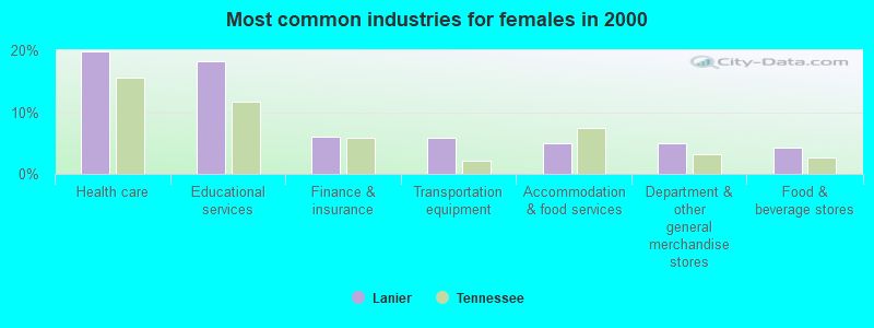
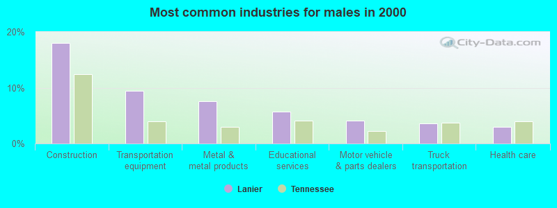
- Health care (19.8%)
- Educational services (18.3%)
- Finance & insurance (6.1%)
- Transportation equipment (5.9%)
- Accommodation & food services (5.0%)
- Department & other general merchandise stores (4.9%)
- Food & beverage stores (4.2%)
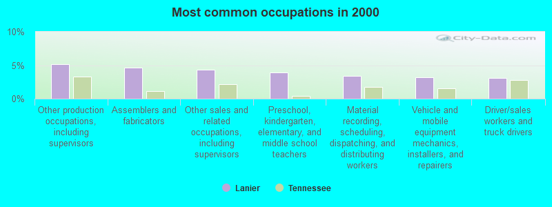
- Other production occupations, including supervisors (5.2%)
- Assemblers and fabricators (4.7%)
- Other sales and related occupations, including supervisors (4.3%)
- Preschool, kindergarten, elementary, and middle school teachers (3.9%)
- Material recording, scheduling, dispatching, and distributing workers (3.4%)
- Vehicle and mobile equipment mechanics, installers, and repairers (3.2%)
- Driver/sales workers and truck drivers (3.1%)
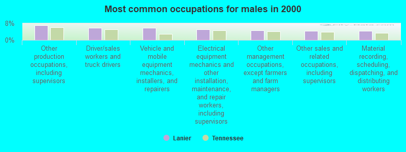
- Other production occupations, including supervisors (7.0%)
- Driver/sales workers and truck drivers (5.8%)
- Vehicle and mobile equipment mechanics, installers, and repairers (5.7%)
- Electrical equipment mechanics and other installation, maintenance, and repair workers, including supervisors (5.1%)
- Other management occupations, except farmers and farm managers (4.6%)
- Other sales and related occupations, including supervisors (4.4%)
- Material recording, scheduling, dispatching, and distributing workers (4.3%)
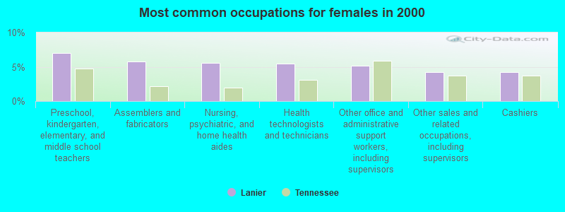
- Preschool, kindergarten, elementary, and middle school teachers (7.0%)
- Assemblers and fabricators (5.7%)
- Nursing, psychiatric, and home health aides (5.6%)
- Health technologists and technicians (5.5%)
- Other office and administrative support workers, including supervisors (5.1%)
- Other sales and related occupations, including supervisors (4.3%)
- Cashiers (4.2%)
Average climate in Lanier, Tennessee
Based on data reported by over 4,000 weather stations


(lower is better)
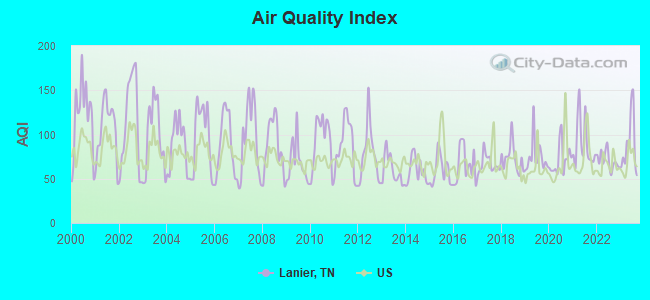
Air Quality Index (AQI) level in 2023 was 88.3. This is worse than average.
| City: | 88.3 |
| U.S.: | 72.6 |
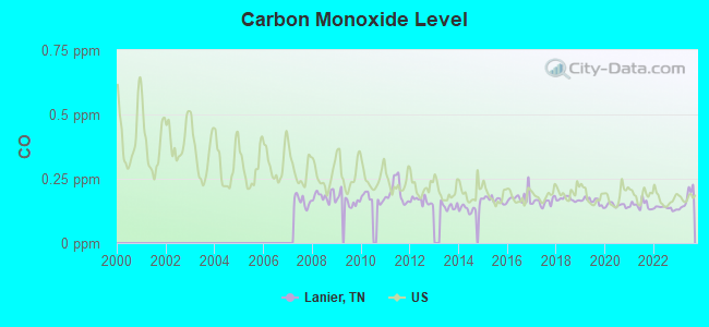
Carbon Monoxide (CO) [ppm] level in 2023 was 0.171. This is significantly better than average. Closest monitor was 5.0 miles away from the city center.
| City: | 0.171 |
| U.S.: | 0.251 |
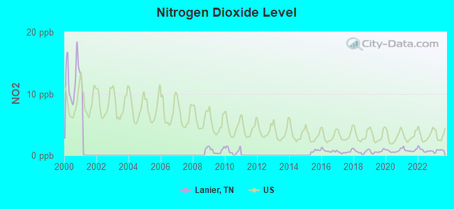
Nitrogen Dioxide (NO2) [ppb] level in 2023 was 0.751. This is significantly better than average. Closest monitor was 5.0 miles away from the city center.
| City: | 0.751 |
| U.S.: | 5.109 |
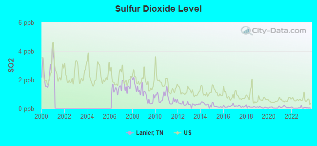
Sulfur Dioxide (SO2) [ppb] level in 2023 was 0.0574. This is significantly better than average. Closest monitor was 5.0 miles away from the city center.
| City: | 0.0574 |
| U.S.: | 1.5147 |
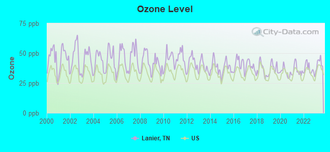
Ozone [ppb] level in 2023 was 41.3. This is worse than average. Closest monitor was 5.0 miles away from the city center.
| City: | 41.3 |
| U.S.: | 33.3 |
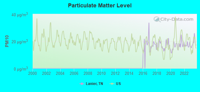
Particulate Matter (PM10) [µg/m3] level in 2023 was 18.9. This is about average. Closest monitor was 5.0 miles away from the city center.
| City: | 18.9 |
| U.S.: | 19.2 |
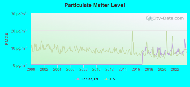
Particulate Matter (PM2.5) [µg/m3] level in 2023 was 9.34. This is about average. Closest monitor was 5.0 miles away from the city center.
| City: | 9.34 |
| U.S.: | 8.11 |
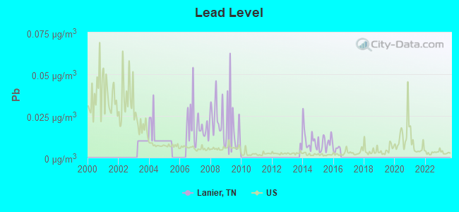
Lead (Pb) [µg/m3] level in 2015 was 0.00868. This is about average. Closest monitor was 8.5 miles away from the city center.
| City: | 0.00868 |
| U.S.: | 0.00931 |
Tornado activity:
Lanier-area historical tornado activity is below Tennessee state average. It is 27% smaller than the overall U.S. average.
On 2/21/1993, a category F3 (max. wind speeds 158-206 mph) tornado 8.5 miles away from the Lanier place center killed one person and injured 55 people and caused between $5000 and $50,000 in damages.
On 4/3/1974, a category F4 (max. wind speeds 207-260 mph) tornado 33.5 miles away from the place center killed 4 people and injured 26 people and caused between $5,000,000 and $50,000,000 in damages.
Earthquake activity:
Lanier-area historical earthquake activity is significantly above Tennessee state average. It is 80% greater than the overall U.S. average.On 11/30/1973 at 07:48:41, a magnitude 4.7 (4.7 MB, 4.6 ML, Class: Light, Intensity: IV - V) earthquake occurred 12.3 miles away from the city center
On 7/27/1980 at 18:52:21, a magnitude 5.2 (5.1 MB, 4.7 MS, 5.0 UK, 5.2 UK, Class: Moderate, Intensity: VI - VII) earthquake occurred 178.2 miles away from Lanier center
On 4/29/2003 at 08:59:39, a magnitude 4.9 (4.4 MB, 4.6 MW, 4.9 LG) earthquake occurred 119.8 miles away from Lanier center
On 8/9/2020 at 12:07:37, a magnitude 5.1 (5.1 MW, Depth: 4.7 mi) earthquake occurred 174.3 miles away from the city center
On 12/12/2018 at 09:14:43, a magnitude 4.4 (4.4 MW, Depth: 4.9 mi) earthquake occurred 39.5 miles away from the city center
On 8/2/1974 at 08:52:09, a magnitude 4.9 (4.3 MB, 4.9 LG) earthquake occurred 149.9 miles away from Lanier center
Magnitude types: regional Lg-wave magnitude (LG), body-wave magnitude (MB), local magnitude (ML), surface-wave magnitude (MS), moment magnitude (MW)
Natural disasters:
The number of natural disasters in Blount County (13) is near the US average (15).Major Disasters (Presidential) Declared: 8
Emergencies Declared: 2
Causes of natural disasters: Floods: 8, Storms: 6, Tornadoes: 4, Heavy Rains: 2, Winds: 2, Winter Storms: 2, Flash Flood: 1, Hurricane: 1, Landslide: 1, Mudslide: 1, Snowfall: 1, Other: 1 (Note: some incidents may be assigned to more than one category).
Hospitals and medical centers near Lanier:
- COLONIAL HILLS NURSING CENTER (Nursing Home, about 7 miles away; MARYVILLE, TN)
- HILLHAVEN MARYVILLE CONVALESCENT CTR (Nursing Home, about 8 miles away; MARYVILLE, TN)
- KINDRED NURSING AND REHABILITATION-MARYVILLE (Nursing Home, about 8 miles away; MARYVILLE, TN)
- MARYVILLE SURGICAL CENTER (Hospital, about 10 miles away; MARYVILLE, TN)
- BLOUNT MEMORIAL HOSPITAL Acute Care Hospitals (about 10 miles away; MARYVILLE, TN)
- BLOUNT MEMORIAL HOME CARE SERVICES (Home Health Center, about 10 miles away; MARYVILLE, TN)
- TOTAL RENAL CARE, INC. (Dialysis Facility, about 10 miles away; MARYVILLE, TN)
Colleges/universities with over 2000 students nearest to Lanier:
- The University of Tennessee-Knoxville (about 24 miles; Knoxville, TN; Full-time enrollment: 25,483)
- Pellissippi State Community College (about 24 miles; Knoxville, TN; FT enrollment: 7,271)
- Roane State Community College (about 38 miles; Harriman, TN; FT enrollment: 4,302)
- Cleveland State Community College (about 57 miles; Cleveland, TN; FT enrollment: 2,500)
- Western Carolina University (about 57 miles; Cullowhee, NC; FT enrollment: 8,684)
- Lee University (about 58 miles; Cleveland, TN; FT enrollment: 4,422)
- Walters State Community College (about 60 miles; Morristown, TN; FT enrollment: 4,359)
Points of interest:
Notable locations in Lanier: Cooper Road Campsite (A), Carpenter Campground (B), Camp Montvale (C), Tallassee Boat Launching Ramp (D), Harrison Branch Boat Launching Ramp (E), Flint Gap Campsite (F), Sheep Pen Gap Campsite (G), Maryville Dragway (H), Deadmans Curve (I), Abrams Creek Campground (J), Scona Lodge Ferry (K). Display/hide their locations on the map
Churches in Lanier include: Four Mile Baptist Church (A), Happy Valley Missionary Baptist Church (B), Liberty Church (C), Carpenters Campground Methodist Church (D), Bakers Creek Presbyterian Church (E), Gospel Church (F), Gospel Temple Church (G), Kagleys Chapel Baptist Church (H), Williamsons Chapel Methodist Church (I). Display/hide their locations on the map
Cemeteries: Lambert Cemetery (1), Williamsons Chapel Cemetery (2), Happy Valley Cemetery (3), Boone Cemetery (4), Chilhowee Cemetery (5), Kagleys Chapel Cemetery (6), Four Mile Cemetery (7). Display/hide their locations on the map
Lakes and reservoirs: Armstrong Pond (A), Howard Pond (B), Kagley Lake (C), Cove Lake (D), Lanier Lake (E). Display/hide their locations on the map
Streams, rivers, and creeks: Blacksmith Branch (A), Lynn Gap Branch (B), Little Ninemile Creek (C), Lick Branch (D), Abrams Creek (E), Sixmile Creek (F), Chilogatee Branch (G), Irwin Branch (H), Little Mountain Branch (I). Display/hide their locations on the map
Parks in Lanier include: Harrison Branch Recreation Area (1), Tallassee Recreation Area (2). Display/hide their locations on the map
| This place: | 2.6 people |
| Tennessee: | 2.5 people |
| This place: | 70.9% |
| Whole state: | 69.8% |
| This place: | 3.4% |
| Whole state: | 4.2% |
Likely homosexual households (counted as self-reported same-sex unmarried-partner households)
- Lesbian couples: 0.1% of all households
- Gay men: 0.2% of all households
| This place: | 9.6% |
| Whole state: | 13.5% |
| This place: | 3.7% |
| Whole state: | 5.8% |
For population 15 years and over in Lanier:
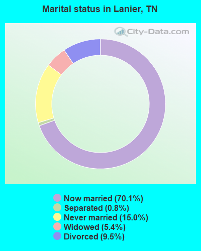
- Never married: 15.0%
- Now married: 70.1%
- Separated: 0.8%
- Widowed: 5.4%
- Divorced: 9.5%
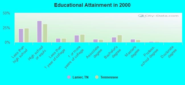
For population 25 years and over in Lanier:
- High school or higher: 76.8%
- Bachelor's degree or higher: 15.8%
- Graduate or professional degree: 7.2%
- Unemployed: 3.4%
- Mean travel time to work (commute): 27.6 minutes
| Here: | 13.0 |
| Tennessee average: | 13.3 |
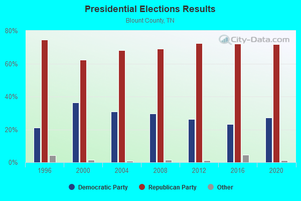
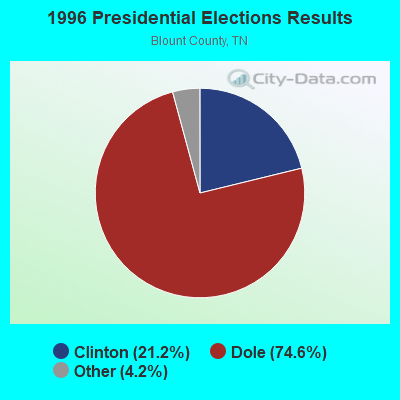
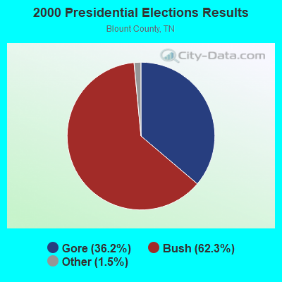
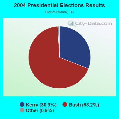
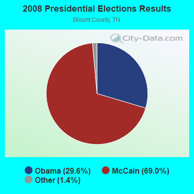

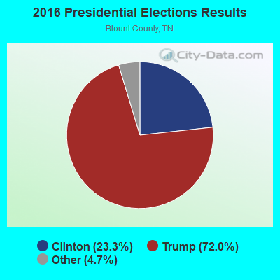

Graphs represent county-level data. Detailed 2008 Election Results
Religion statistics for Lanier, TN (based on Blount County data)
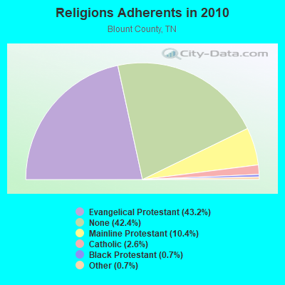
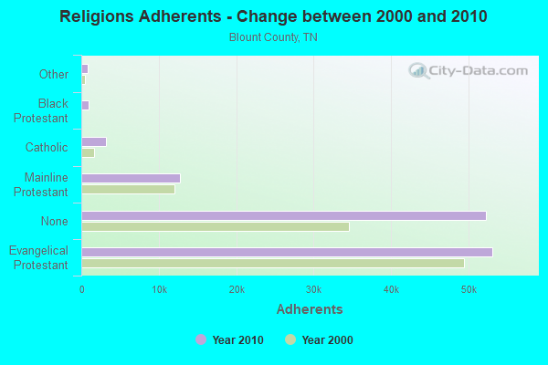
| Religion | Adherents | Congregations |
|---|---|---|
| Evangelical Protestant | 53,117 | 137 |
| Mainline Protestant | 12,736 | 34 |
| Catholic | 3,221 | 3 |
| Black Protestant | 891 | 7 |
| Other | 834 | 5 |
| Orthodox | - | - |
| None | 52,211 | - |
Food Environment Statistics:
| Blount County: | 1.34 / 10,000 pop. |
| Tennessee: | 1.99 / 10,000 pop. |
| Here: | 0.08 / 10,000 pop. |
| Tennessee: | 0.17 / 10,000 pop. |
| Blount County: | 0.42 / 10,000 pop. |
| Tennessee: | 0.65 / 10,000 pop. |
| Blount County: | 5.10 / 10,000 pop. |
| Tennessee: | 5.16 / 10,000 pop. |
| Here: | 6.27 / 10,000 pop. |
| Tennessee: | 6.56 / 10,000 pop. |
| Blount County: | 11.9% |
| Tennessee: | 11.4% |
| Blount County: | 29.9% |
| State: | 30.2% |
| This county: | 27.0% |
| State: | 13.5% |
Strongest AM radio stations in Lanier:
- WKVL (850 AM; daytime; 50 kW; KNOXVILLE, TN; Owner: HORNE RADIO, LLC)
- WVLZ (1180 AM; daytime; 10 kW; KNOXVILLE, TN; Owner: KIRKLAND WIRELESS BROADCASTERS, INC.)
- WQBB (1040 AM; daytime; 10 kW; POWELL, TN; Owner: JOURNAL BROADCAST CORPORATION)
- WNOX (990 AM; 10 kW; KNOXVILLE, TN)
- WRJZ (620 AM; 5 kW; KNOXVILLE, TN; Owner: TENNESSEE MEDIA ASSOCIATES, INC)
- WGAP (1400 AM; 1 kW; MARYVILLE, TN; Owner: HORNE RADIO, LLC)
- WMTY (670 AM; daytime; 2 kW; FARRAGUT, TN; Owner: HORNE RADIO, LLC)
- WLFJ (660 AM; daytime; 50 kW; GREENVILLE, SC; Owner: CLEAR CHANNEL BROADCASTING LICENSES, INC.)
- WFLI (1070 AM; 50 kW; LOOKOUT MOUNTAIN, TN; Owner: WFLI, INC.)
- WWAM (820 AM; daytime; 50 kW; JASPER, TN; Owner: SHELTON BROADCASTING SYSTEM)
- WFGW (1010 AM; 50 kW; BLACK MOUNTAIN, NC; Owner: BLUE RIDGE BROADCASTING CORP.)
- WSEV (930 AM; 5 kW; SEVIERVILLE, TN; Owner: EAST TENNESSEE RADIO GROUP, L.P.)
- WCNN (680 AM; 50 kW; NORTH ATLANTA, GA; Owner: DICKEY BROADCASTING COMPANY)
Strongest FM radio stations in Lanier:
- WOKI-FM (100.3 FM; OAK RIDGE, TN; Owner: OAK RIDGE FM, INC.)
- WIVK-FM (107.7 FM; KNOXVILLE, TN; Owner: CITADEL BROADCASTING COMPANY)
- WWST (102.1 FM; SEVIERVILLE, TN; Owner: JOURNAL BROADCAST CORPORATION)
- WCVP-FM (95.9 FM; ROBBINSVILLE, NC; Owner: CHEROKEE BROADCASTING COMPANY, INC.)
- WUOT (91.9 FM; KNOXVILLE, TN; Owner: UNIVERSITY OF TENNESSEE)
- WFQS (91.3 FM; FRANKLIN, NC; Owner: WESTERN NORTH CAROLINA PUBLIC RADIO)
- WJXB-FM (97.5 FM; KNOXVILLE, TN; Owner: SOUTH CENTRAL COMMUNICATIONS CORP.)
- WDVX (89.9 FM; CLINTON, TN; Owner: CUMBERLAND COMMUNITIES COMMUNI CORP.)
- WKZX-FM (93.5 FM; LENOIR CITY, TN; Owner: BP BROADCASTERS, LLC)
- WSEV-FM (105.5 FM; GATLINBURG, TN; Owner: EAST TENNESSEE RADIO GROUP, L.P.)
- WIMZ-FM (103.5 FM; KNOXVILLE, TN; Owner: SOUTH CENTRAL COMM., CORP.)
- WYLV (89.1 FM; ALCOA, TN; Owner: FOOTHILLS BROADCASTING, INC.)
- W237AR (95.3 FM; HAZELWOOD, ETC., NC; Owner: WESTERN NORTH CAROLINA PUBLIC RADIO)
- WNFZ (94.3 FM; OAK RIDGE, TN; Owner: JOHN W. PIRKLE)
- WTXM-FM (95.7 FM; MARYVILLE, TN; Owner: SOUTH CENTRAL COMMUNICATIONS CORP.)
- WYIL-FM (98.7 FM; OLIVER SPRINGS, TN; Owner: CITADEL BROADCASTING COMPANY)
- WLLJ (103.1 FM; ETOWAH, TN; Owner: FRIENDSHIP BROADCASTING LLC.)
- WLOD-FM (98.3 FM; SWEETWATER, TN; Owner: HORNE RADIO, LLC)
- WWSR (105.7 FM; ROCKWOOD, TN; Owner: SOUTHERN MEDIA GROUP, INC.)
- WNCC-FM (96.7 FM; FRANKLIN, NC; Owner: SUTTON RADIOCASTING CORPORATION)
TV broadcast stations around Lanier:
- WDTT-LP (Channel 38; LENOIR CITY, TN; Owner: WORD OF GOD FELLOWSHIP, INC.)
- WVLT-TV (Channel 8; KNOXVILLE, TN; Owner: WVLT LICENSEE CORP.)
- WKOP-TV (Channel 15; KNOXVILLE, TN; Owner: EAST TENNESSEE PUBLIC COMMUNICATIONS CORP.)
- W50AB (Channel 50; HIAWASSEE, GA; Owner: GEORGIA PUBLIC TELECOMMUNICATIONS COMMISSION)
- WBIR-TV (Channel 10; KNOXVILLE, TN; Owner: GANNETT PACIFIC CORPORATION)
- W46DC (Channel 46; KNOXVILLE, TN; Owner: TRINITY BROADCASTING NETWORK)
- WATE-TV (Channel 6; KNOXVILLE, TN; Owner: WATE, G.P.)
- WTNZ (Channel 43; KNOXVILLE, TN; Owner: RAYCOM AMERICA, INC.)
- WEEE-LP (Channel 32; KNOXVILLE, TN; Owner: TIGER EYE BROADCASTING CORPORATION)
- WEZK-LP (Channel 28; KNOXVILLE, TN; Owner: SOUTH CENTRAL COMMUNICATIONS CORP.)
- W50CG (Channel 50; KNOXVILLE, TN; Owner: THREE ANGELS BROADCASTING NETWORK, INC.)
- W56CM (Channel 56; KNOXVILLE, TN; Owner: VENTANA TELEVISION, INC.)
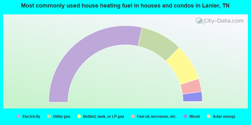
- 57.0%Electricity
- 17.7%Utility gas
- 15.5%Bottled, tank, or LP gas
- 5.5%Fuel oil, kerosene, etc.
- 4.1%Wood
- 0.3%Solar energy
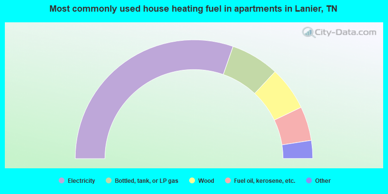
- 60.7%Electricity
- 13.2%Bottled, tank, or LP gas
- 11.9%Wood
- 9.3%Fuel oil, kerosene, etc.
- 2.5%Other fuel
- 2.3%Utility gas
Lanier compared to Tennessee state average:
- Unemployed percentage significantly below state average.
- Black race population percentage significantly below state average.
- Hispanic race population percentage significantly below state average.
- Foreign-born population percentage significantly below state average.
- Renting percentage significantly below state average.
- Length of stay since moving in significantly above state average.
- Number of rooms per house significantly below state average.
- House age significantly below state average.
- Institutionalized population percentage significantly above state average.
- Number of college students below state average.
Lanier on our top lists:
- #15 on the list of "Top 101 cities with largest percentage of females in occupations: assemblers and fabricators (population 5,000+)"
- #16 on the list of "Top 101 cities with largest percentage of males in occupations: electricians (population 5,000+)"
- #22 on the list of "Top 101 cities with largest percentage of females in industries: transportation equipment (population 5,000+)"
- #27 on the list of "Top 101 cities with largest percentage of females in occupations: other food preparation and serving workers including supervisors (population 5,000+)"
- #28 on the list of "Top 101 cities with largest percentage of females in occupations: communications equipment operators (population 5,000+)"
- #32 on the list of "Top 101 cities with largest percentage of females in industries: wood products (population 5,000+)"
- #37 on the list of "Top 101 cities with largest percentage of females in occupations: construction trades workers except carpenters, electricians, painters, plumbers, and construction laborers (population 5,000+)"
- #37 on the list of "Top 101 cities with largest percentage of females in occupations: fishing and hunting, and forest and logging workers (population 5,000+)"
- #42 on the list of "Top 101 cities with largest percentage of males in industries: nonmetallic mineral products (population 5,000+)"
- #42 on the list of "Top 100 least racially diverse cities (pop. 5,000+)"
- #45 on the list of "Top 101 cities with largest percentage of males in industries: farm supplies merchant wholesalers (population 5,000+)"
- #49 on the list of "Top 101 cities with largest percentage of males in industries: transportation equipment (population 5,000+)"
- #55 on the list of "Top 101 cities with largest percentage of males in industries: metal and metal products (population 5,000+)"
- #56 on the list of "Top 101 cities with largest percentage of females in industries: vending machine operators (population 5,000+)"
- #59 on the list of "Top 101 cities with largest percentage of males in industries: retail florists (population 5,000+)"
- #65 on the list of "Top 101 cities with largest percentage of males in industries: motor vehicle and parts dealers (population 5,000+)"
- #21 (37803) on the list of "Top 101 zip codes with the largest percentage of Scotch-Irish first ancestries (pop 5,000+)"
- #8 on the list of "Top 101 counties with the lowest percentage of residents relocating from foreign countries between 2010 and 2011"
- #9 on the list of "Top 101 counties with the lowest ground withdrawal of fresh water for public supply (pop. 50,000+)"
- #21 on the list of "Top 101 counties with the highest Ozone (1-hour) air pollution readings in 2012 (ppm)"
- #54 on the list of "Top 101 counties with the lowest Sulfur Oxides Annual air pollution readings in 2012 (µg/m3)"
- #60 on the list of "Top 101 counties with the lowest percentage of residents relocating to foreign countries in 2011"