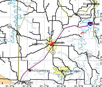
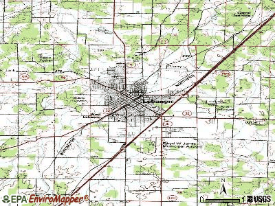
Lebanon, Missouri
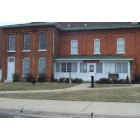
Lebanon: 1876 Historic Jailhouse & Museum on the National Register
Lebanon: Tree(face)
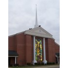
Lebanon: First Baptist Church on Madison Street
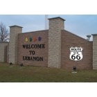
Lebanon: Welcome to Lebanon sign along Interstate 44
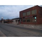
Lebanon: Downtown Lebanon
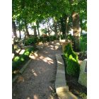
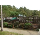
Lebanon: A park, in Lebanon
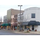
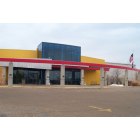
Lebanon: Downtown business district, Commercial Street
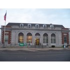
Lebanon: Lebanon Post Office located on Commercial Street
Lebanon
Lebanon: Peggy Palmer Summers Memorial Library
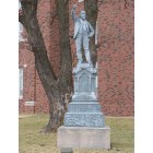
Lebanon: Statue on courthouse grounds of Richard Parks Bland, Deceased Statesman
- add
your
Submit your own pictures of this city and show them to the world
- OSM Map
- General Map
- Google Map
- MSN Map
Population change since 2000: +25.3%
 |
| Males: 7,606 | |
| Females: 7,626 |
| Median resident age: | 35.4 years |
| Missouri median age: | 39.1 years |
Zip codes: 65536.
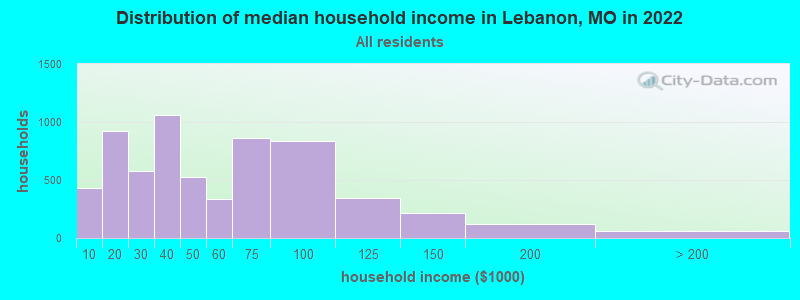
| Lebanon: | $44,866 |
| MO: | $64,811 |
Estimated per capita income in 2022: $26,887 (it was $16,636 in 2000)
Lebanon city income, earnings, and wages data
Estimated median house or condo value in 2022: $154,197 (it was $65,600 in 2000)
| Lebanon: | $154,197 |
| MO: | $221,200 |
Mean prices in 2022: all housing units: $153,889; detached houses: $165,403; townhouses or other attached units: $198,208; mobile homes: $39,237
Median gross rent in 2022: $779.
(20.2% for White Non-Hispanic residents, 4.5% for Black residents, 28.1% for Hispanic or Latino residents, 21.2% for American Indian residents, 5.5% for other race residents, 35.7% for two or more races residents)
Detailed information about poverty and poor residents in Lebanon, MO


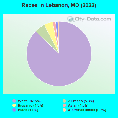
- 13,19487.5%White alone
- 7965.3%Two or more races
- 6524.3%Hispanic
- 2191.5%Asian alone
- 1451.0%Black alone
- 1000.7%American Indian alone
- 60.04%Native Hawaiian and Other
Pacific Islander alone
Races in Lebanon detailed stats: ancestries, foreign born residents, place of birth
According to our research of Missouri and other state lists, there were 128 registered sex offenders living in Lebanon, Missouri as of April 27, 2024.
The ratio of all residents to sex offenders in Lebanon is 115 to 1.
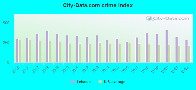
Type |
2009 |
2010 |
2011 |
2012 |
2013 |
2014 |
2015 |
2016 |
2017 |
2018 |
2019 |
2020 |
2021 |
2022 |
|---|---|---|---|---|---|---|---|---|---|---|---|---|---|---|
| Murders (per 100,000) | 1 (6.9) | 2 (13.8) | 0 (0.0) | 0 (0.0) | 0 (0.0) | 1 (6.7) | 0 (0.0) | 0 (0.0) | 0 (0.0) | 2 (13.7) | 0 (0.0) | 0 (0.0) | 2 (13.4) | 1 (6.6) |
| Rapes (per 100,000) | 6 (41.2) | 5 (34.5) | 6 (41.3) | 2 (13.8) | 8 (55.0) | 2 (13.5) | 5 (34.1) | 5 (34.0) | 5 (33.9) | 8 (54.7) | 15 (101.1) | 9 (60.7) | 11 (73.7) | 17 (112.3) |
| Robberies (per 100,000) | 3 (20.6) | 3 (20.7) | 0 (0.0) | 5 (34.4) | 2 (13.7) | 1 (6.7) | 1 (6.8) | 1 (6.8) | 2 (13.6) | 2 (13.7) | 5 (33.7) | 3 (20.2) | 3 (20.1) | 4 (26.4) |
| Assaults (per 100,000) | 52 (356.8) | 41 (283.3) | 57 (392.4) | 63 (433.7) | 60 (412.4) | 51 (344.2) | 51 (347.4) | 63 (428.0) | 37 (251.0) | 45 (307.8) | 40 (269.5) | 80 (539.5) | 52 (348.6) | 36 (237.7) |
| Burglaries (per 100,000) | 98 (672.4) | 109 (753.1) | 100 (688.4) | 86 (592.0) | 91 (625.4) | 74 (499.4) | 85 (578.9) | 86 (584.2) | 102 (692.0) | 104 (711.3) | 93 (626.6) | 124 (836.2) | 53 (355.3) | 46 (303.8) |
| Thefts (per 100,000) | 638 (4,378) | 567 (3,917) | 605 (4,165) | 592 (4,075) | 574 (3,945) | 535 (3,610) | 544 (3,705) | 340 (2,310) | 562 (3,813) | 562 (3,844) | 567 (3,820) | 591 (3,985) | 399 (2,675) | 331 (2,186) |
| Auto thefts (per 100,000) | 22 (151.0) | 28 (193.5) | 23 (158.3) | 21 (144.6) | 19 (130.6) | 22 (148.5) | 27 (183.9) | 17 (115.5) | 63 (427.4) | 65 (444.5) | 49 (330.2) | 53 (357.4) | 65 (435.7) | 40 (264.1) |
| Arson (per 100,000) | 3 (20.6) | 4 (27.6) | 0 (0.0) | 0 (0.0) | 0 (0.0) | 2 (13.5) | 2 (13.6) | 4 (27.2) | 2 (13.6) | 2 (13.7) | 10 (67.4) | 2 (13.5) | 2 (13.4) | 6 (39.6) |
| City-Data.com crime index | 358.4 | 343.0 | 339.0 | 324.1 | 342.6 | 286.4 | 302.2 | 257.3 | 316.6 | 375.9 | 368.0 | 409.1 | 328.3 | 288.3 |
The City-Data.com crime index weighs serious crimes and violent crimes more heavily. Higher means more crime, U.S. average is 246.1. It adjusts for the number of visitors and daily workers commuting into cities.
Crime rate in Lebanon detailed stats: murders, rapes, robberies, assaults, burglaries, thefts, arson
Full-time law enforcement employees in 2021, including police officers: 36 (24 officers - 20 male; 4 female).
| Officers per 1,000 residents here: | 1.61 |
| Missouri average: | 2.54 |
 Recent articles from our blog. Our writers, many of them Ph.D. graduates or candidates, create easy-to-read articles on a wide variety of topics.

 | Life 20 min. South East of Lebanon, MO (2 replies) |
| Missouri Outlaw History (3407 replies) |
| Passing of MO native and Radio legend (0 replies) |
| Why is Missouri so southern? (297 replies) |
| What would you call the most mountainous/scenic part of the MO Ozarks? (18 replies) |
| Is Kansas City a Western city? (278 replies) |
Latest news from Lebanon, MO collected exclusively by city-data.com from local newspapers, TV, and radio stations
Ancestries: American (19.5%), Irish (17.0%), English (12.9%), German (12.0%), European (3.4%), French (2.9%).
Current Local Time: CST time zone
Incorporated in 1959
Elevation: 1265 feet
Land area: 13.6 square miles.
Population density: 1,118 people per square mile (low).
314 residents are foreign born (1.0% Latin America, 0.6% Asia, 0.6% Europe).
| This city: | 2.1% |
| Missouri: | 4.2% |
Median real estate property taxes paid for housing units with mortgages in 2022: $1,191 (0.7%)
Median real estate property taxes paid for housing units with no mortgage in 2022: $964 (0.7%)
Nearest city with pop. 50,000+: Springfield, MO  (47.9 miles , pop. 151,580).
Nearest city with pop. 200,000+: Kansas City, MO (141.0 miles , pop. 441,545).
Nearest city with pop. 1,000,000+: Chicago, IL (391.1 miles , pop. 2,896,016).
Nearest cities:
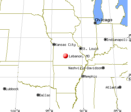
), ), ), Latitude: 37.68 N, Longitude: 92.66 W
Daytime population change due to commuting: +6,318 (+41.9%)
Workers who live and work in this city: 5,695 (83.3%)
Area code: 417

Lebanon, Missouri accommodation & food services, waste management - Economy and Business Data
Single-family new house construction building permits:
- 2022: 23 buildings, average cost: $168,200
- 2021: 48 buildings, average cost: $166,500
- 2020: 41 buildings, average cost: $162,200
- 2019: 17 buildings, average cost: $171,900
- 2018: 14 buildings, average cost: $115,600
- 2017: 57 buildings, average cost: $127,300
- 2016: 13 buildings, average cost: $237,400
- 2015: 18 buildings, average cost: $165,400
- 2014: 15 buildings, average cost: $180,100
- 2013: 12 buildings, average cost: $177,400
- 2012: 9 buildings, average cost: $152,900
- 2011: 6 buildings, average cost: $125,000
- 2010: 18 buildings, average cost: $208,600
- 2009: 18 buildings, average cost: $222,200
- 2008: 25 buildings, average cost: $99,800
- 2007: 37 buildings, average cost: $99,800
- 2006: 71 buildings, average cost: $99,900
- 2005: 83 buildings, average cost: $99,800
- 2004: 79 buildings, average cost: $100,300
- 2003: 77 buildings, average cost: $96,800
- 2002: 64 buildings, average cost: $116,300
- 2001: 69 buildings, average cost: $90,800
- 2000: 76 buildings, average cost: $86,100
- 1999: 47 buildings, average cost: $91,000
- 1998: 204 buildings, average cost: $56,400
- 1997: 93 buildings, average cost: $80,400
| Here: | 3.4% |
| Missouri: | 2.8% |
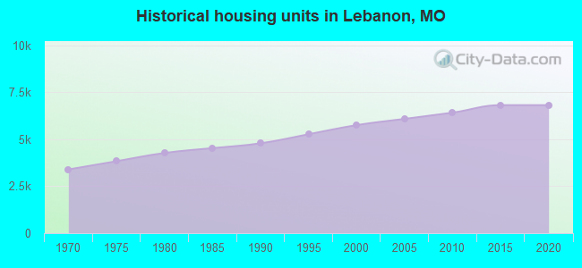
Population change in the 1990s: +1,552 (+14.6%).
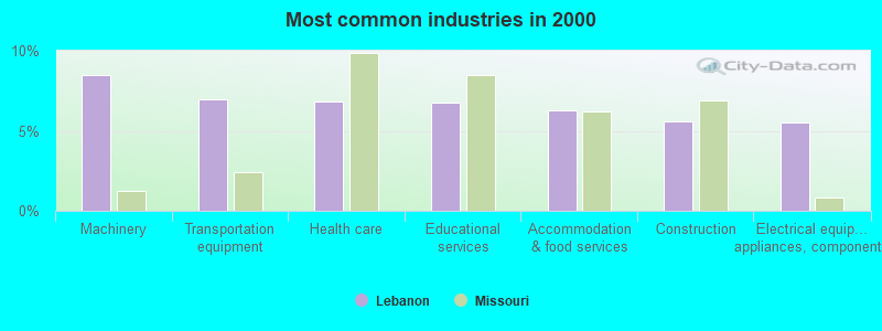
- Machinery (8.4%)
- Transportation equipment (7.0%)
- Health care (6.9%)
- Educational services (6.8%)
- Accommodation & food services (6.3%)
- Construction (5.6%)
- Electrical equipment, appliances, components (5.5%)
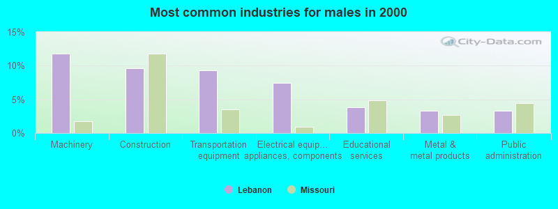
- Machinery (11.8%)
- Construction (9.6%)
- Transportation equipment (9.3%)
- Electrical equipment, appliances, components (7.4%)
- Educational services (3.8%)
- Metal & metal products (3.3%)
- Public administration (3.3%)
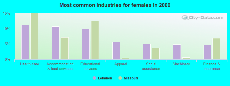
- Health care (11.2%)
- Accommodation & food services (10.7%)
- Educational services (9.9%)
- Apparel (5.7%)
- Social assistance (5.1%)
- Machinery (4.9%)
- Finance & insurance (4.7%)
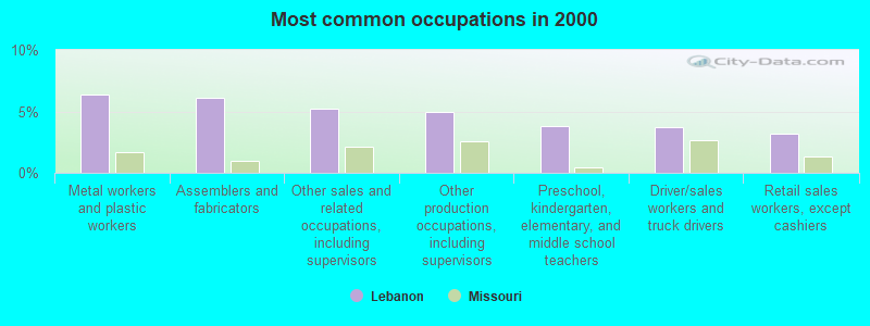
- Metal workers and plastic workers (6.4%)
- Assemblers and fabricators (6.1%)
- Other sales and related occupations, including supervisors (5.2%)
- Other production occupations, including supervisors (5.0%)
- Preschool, kindergarten, elementary, and middle school teachers (3.8%)
- Driver/sales workers and truck drivers (3.7%)
- Retail sales workers, except cashiers (3.2%)
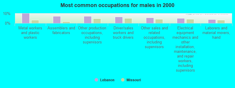
- Metal workers and plastic workers (9.9%)
- Assemblers and fabricators (7.4%)
- Other production occupations, including supervisors (7.2%)
- Driver/sales workers and truck drivers (6.7%)
- Other sales and related occupations, including supervisors (5.9%)
- Electrical equipment mechanics and other installation, maintenance, and repair workers, including supervisors (5.1%)
- Laborers and material movers, hand (4.0%)
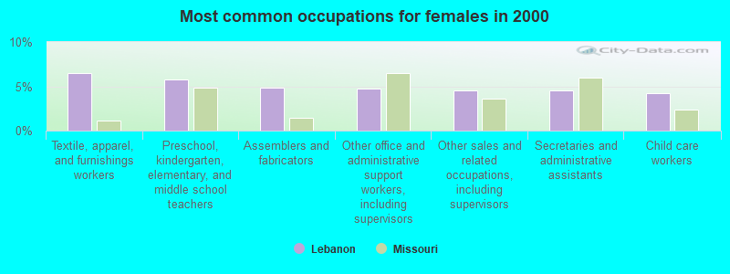
- Textile, apparel, and furnishings workers (6.5%)
- Preschool, kindergarten, elementary, and middle school teachers (5.8%)
- Assemblers and fabricators (4.8%)
- Other office and administrative support workers, including supervisors (4.8%)
- Other sales and related occupations, including supervisors (4.5%)
- Secretaries and administrative assistants (4.5%)
- Child care workers (4.2%)
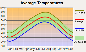
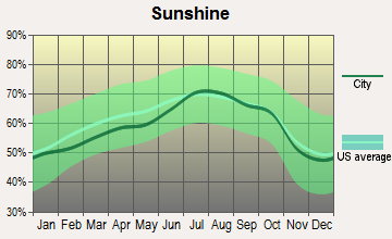
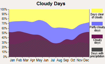
Average climate in Lebanon, Missouri
Based on data reported by over 4,000 weather stations
|
|


Tornado activity:
Lebanon-area historical tornado activity is slightly below Missouri state average. It is 21% greater than the overall U.S. average.
On 9/26/1959, a category F4 (max. wind speeds 207-260 mph) tornado 17.9 miles away from the Lebanon city center caused between $50,000 and $500,000 in damages.
On 3/25/1954, a category F4 tornado 34.3 miles away from the city center killed 2 people and caused between $5000 and $50,000 in damages.
Earthquake activity:
Lebanon-area historical earthquake activity is significantly above Missouri state average. It is 494% greater than the overall U.S. average.On 9/3/2016 at 12:02:44, a magnitude 5.8 (5.8 MW, Depth: 3.5 mi, Class: Moderate, Intensity: VI - VII) earthquake occurred 251.0 miles away from Lebanon center
On 11/6/2011 at 03:53:10, a magnitude 5.7 (5.7 MW, Depth: 3.2 mi) earthquake occurred 271.9 miles away from the city center
On 5/4/1991 at 01:18:54, a magnitude 5.0 (4.4 MB, 4.6 LG, 5.0 LG, Depth: 3.1 mi) earthquake occurred 174.5 miles away from the city center
On 9/26/1990 at 13:18:51, a magnitude 5.0 (4.7 MB, 4.8 LG, 5.0 LG, Depth: 7.7 mi) earthquake occurred 175.3 miles away from the city center
On 4/18/2008 at 09:36:59, a magnitude 5.4 (5.1 MB, 4.8 MS, 5.4 MW, 5.2 MW) earthquake occurred 265.5 miles away from Lebanon center
On 3/25/1976 at 00:41:20, a magnitude 5.0 (4.9 MB, 5.0 LG) earthquake occurred 191.6 miles away from the city center
Magnitude types: regional Lg-wave magnitude (LG), body-wave magnitude (MB), surface-wave magnitude (MS), moment magnitude (MW)
Natural disasters:
The number of natural disasters in Laclede County (22) is greater than the US average (15).Major Disasters (Presidential) Declared: 14
Emergencies Declared: 6
Causes of natural disasters: Floods: 14, Storms: 13, Tornadoes: 10, Winds: 5, Winter Storms: 5, Drought: 1, Heavy Rain: 1, Hurricane: 1, Snowstorm: 1, Other: 1 (Note: some incidents may be assigned to more than one category).
Hospitals and medical centers in Lebanon:
- MERCY HOSPITAL LEBANON (Voluntary non-profit - Church, provides emergency services, 100 HOSPITAL DRIVE)
- BREECH MEDICAL CENTER (325 HARWOOD AVE)
- CHRISTIAN HEALTH AND REHAB OF LEBANON SOUTH (514 WEST FREMONT ROAD)
- CHRISTIAN HEALTH AND REHABILITATION OF LEBANON NORTH (596 MORTON ROAD)
- RENAL CARE GROUP - LEBANON (331 HOSPITAL DRIVE SUITE F)
Airports and heliports located in Lebanon:
- Floyd W Jones Lebanon Airport (LBO) (Runways: 1, Air Taxi Ops: 675, Itinerant Ops: 10,500, Local Ops: 1,450, Military Ops: 100)
- Matzie Airport (30MO) (Runways: 1)
- Mercy Hospital-Lebanon Heliport (46MO)
College/University in Lebanon:
Colleges/universities with over 2000 students nearest to Lebanon:
- Southwest Baptist University (about 42 miles; Bolivar, MO; Full-time enrollment: 2,783)
- Evangel University (about 46 miles; Springfield, MO; FT enrollment: 2,036)
- Ozarks Technical Community College (about 47 miles; Springfield, MO; FT enrollment: 10,356)
- Drury University (about 47 miles; Springfield, MO; FT enrollment: 3,902)
- Missouri State University-Springfield (about 48 miles; Springfield, MO; FT enrollment: 16,660)
- Missouri University of Science and Technology (about 53 miles; Rolla, MO; FT enrollment: 6,486)
- Lincoln University (about 67 miles; Jefferson City, MO; FT enrollment: 2,348)
Public high schools in Lebanon:
- LEBANON SR. HIGH (Students: 1,382, Location: 777 BRICE ST, Grades: 9-12)
- LEBANON TECH. CAREER CTR. (Location: 757 BRICE ST, Grades: 9-12)
- LEBANON ALTERNATIVE EDUC. CTR. (Location: 1015 N JEFFERSON, Grades: 7-12)
Public elementary/middle schools in Lebanon:
- JOE D. ESTHER ELEM. (Students: 844, Location: 1200 CLARK ST, Grades: PK-1)
- LEBANON JR. HIGH (Students: 690, Location: 500 N ADAMS, Grades: 7-8)
- MAPLECREST ELEM. (Students: 688, Location: 901 MAPLE LN, Grades: 2-3)
- BOSWELL ELEM. (Students: 637, Location: 695 MILLCREEK, Grades: 4-5)
- JOEL E. BARBER ELEM. (Students: 491, Location: 16050 HWY KK, Grades: PK-8)
- HILLCREST SCHOOL (Location: 301 HOOVER, Grades: 6)
User-submitted facts and corrections:
- LEBANON-LACLEDE COUNTY LIBRARY Has Moved to New Address 915 S Jefferson Av. Lebanon Mop. added by Jim
Points of interest:
Notable locations in Lebanon: Azure Hills Golf Course (A), Department of Conservation Southwest Field Fire Office Lebanon (B), The City of Lebanon Fire Department Main Station (C), Lebanon Rural Fire Protection District Station 1 Headquarters (D), The City of Lebanon Fire Department Station 2 (E). Display/hide their locations on the map
Churches in Lebanon include: Highland Park Church (A), South Five Church (B), Southern Heights Church (C). Display/hide their locations on the map
Cemetery: Lebanon Cemetery (1). Display/hide its location on the map
Lake: Horseshoe Lake (A). Display/hide its location on the map
Parks in Lebanon include: Mount Rose Memorial Park (1), Maplecrest Park (2). Display/hide their locations on the map
Tourist attractions: Laclede Literacy Council-Lva (Cultural Attractions- Events- & Facilities; 915 South Jefferson Avenue), Lebanon Wholesale Supply (Amusement & Theme Parks; 396 Harrison Street), Funplex (Amusement & Theme Parks; 695 S Monroe Street), Enchanted Valley Intrests (Amusement & Theme Parks; 721 East Elm Street).
Hotels: Days Inn Lebanon MO (2071W Elm Street), Budget Inn (1140 Millcreek Road), Econo Lodge Lebanon (2125 West Elm Street), Forest Manor Motel & Campground (207 East Seminole Street), Historic Route 66 Inn (1710 West Elm Street), Econo Lodge (2125 West Elm Street), Best Western Wyota Inn (1235 Millcreek Road), Holiday Inn Express Hotel & Suites (1955 West Elm Street), Brentwood Motel (1320 South Jefferson Avenue).
Birthplace of: Betty Wagoner - Baseball player, Antoine Predock - Landscape architect, Michael S. Hopkins - NASA astronaut, William Tecumseh Vernon - Misssionary, Dean Whipple - District Judge, Gordon Hickman Garland - Politician, Lanford Wilson - (born 1937), dramatist, Robert True Donnelly - Judge, John Russell (Missouri) - Politician.
Drinking water stations with addresses in Lebanon and their reported violations in the past:
NIANGUA RIVER OASIS (Population served: 200, Groundwater):Past monitoring violations:MUNGER MOSS MOTEL (Population served: 100, Groundwater):
- 2 minor monitoring violations
Past monitoring violations:WILD OAKS CAMPGROUND (Population served: 50, Groundwater):
- Monitoring, Source Water (GWR) - In JUL-01-2011, Contaminant: E. COLI. Follow-up actions: St Violation/Reminder Notice (AUG-23-2011), St Public Notif requested (AUG-23-2011)
- Monitoring, Repeat Major (TCR) - In JUL-2011, Contaminant: Coliform (TCR). Follow-up actions: St Public Notif requested (AUG-23-2011), St Violation/Reminder Notice (AUG-23-2011), St Public Notif received (SEP-21-2011), St Compliance achieved (JAN-22-2014)
- One minor monitoring violation
Past health violations:LARRYS CEDAR RESORT (Population served: 47, Groundwater):Past monitoring violations:
- MCL, Monthly (TCR) - In JUN-2014, Contaminant: Coliform
- MCL, Monthly (TCR) - In MAY-2014, Contaminant: Coliform. Follow-up actions: St Formal NOV issued (JUN-09-2014), St Public Notif requested (JUN-09-2014)
- MCL, Monthly (TCR) - In AUG-2009, Contaminant: Coliform. Follow-up actions: St Public Notif requested (SEP-08-2009), St Violation/Reminder Notice (SEP-08-2009), St Public Notif received (SEP-12-2009), St Compliance achieved (SEP-30-2010), St Public Notif issued (2 times from MAR-06-2012 to AUG-07-2012)
- Monitoring, Source Water (GWR) - In JUL-01-2012, Contaminant: E. COLI. Follow-up actions: St Public Notif requested (JUL-18-2012), St Violation/Reminder Notice (2 times from JUL-18-2012 to OCT-02-2012), St Public Notif received (MAR-03-2014)
- Monitoring, Source Water (GWR) - In MAY-01-2011, Contaminant: E. COLI. Follow-up actions: St Public Notif requested (JUN-21-2011), St Violation/Reminder Notice (JUN-21-2011), St Compliance achieved (MAR-31-2012), St Public Notif received (MAR-03-2014)
- 13 routine major monitoring violations
- 8 minor monitoring violations
Past monitoring violations:HO HUMM CAMPGROUND (Address: 30651 MARIGOLD DRIVE , Population served: 30, Groundwater):
- One routine major monitoring violation
Past health violations:TRISHS GAS AND GRILL (Population served: 25, Groundwater):Past monitoring violations:
- MCL, Acute (TCR) - In AUG-2013, Contaminant: Coliform. Follow-up actions: St Boil Water Order (SEP-03-2013), St Public Notif requested (SEP-06-2013), St Formal NOV issued (2 times from SEP-06-2013 to NOV-20-2013), St BCA signed (JAN-15-2014), St Public Notif received (FEB-10-2014), St Other (APR-11-2014)
- MCL, Monthly (TCR) - In AUG-2013, Contaminant: Coliform. Follow-up actions: St Public Notif requested (SEP-06-2013), St Formal NOV issued (2 times from SEP-06-2013 to NOV-20-2013), St BCA signed (JAN-15-2014), St Public Notif received (FEB-10-2014)
- MCL, Monthly (TCR) - In MAY-2013, Contaminant: Coliform. Follow-up actions: St Public Notif requested (JUN-11-2013), St Formal NOV issued (2 times from JUN-11-2013 to NOV-20-2013), St Compliance achieved (NOV-20-2013), St BCA signed (JAN-15-2014), St Public Notif received (MAY-27-2014)
- Monitoring, Source Water (GWR) - In SEP-01-2013, Contaminant: E. COLI. Follow-up actions: St Public Notif requested (OCT-02-2013), St Violation/Reminder Notice (OCT-02-2013), St Formal NOV issued (NOV-20-2013), St BCA signed (JAN-15-2014), St Public Notif received (MAY-27-2014)
- 21 routine major monitoring violations
- 2 minor monitoring violations
Past health violations:MENAGERIE CAMPGROUND (Population served: 25, Groundwater):Past monitoring violations:
- MCL, Monthly (TCR) - In AUG-2007, Contaminant: Coliform. Follow-up actions: St Public Notif requested (SEP-11-2007), St Violation/Reminder Notice (SEP-11-2007), St Public Notif received (SEP-24-2007), St Compliance achieved (JAN-22-2014)
- 7 routine major monitoring violations
- 4 minor monitoring violations
Past health violations:Past monitoring violations:
- MCL, Monthly (TCR) - In MAR-2012, Contaminant: Coliform. Follow-up actions: St Public Notif requested (APR-11-2012), St Violation/Reminder Notice (APR-11-2012), St Compliance achieved (JAN-22-2014)
- 7 routine major monitoring violations
- One minor monitoring violation
Drinking water stations with addresses in Lebanon that have no violations reported:
- SAND SPRING RESORT & CANOE LLC (Population served: 175, Primary Water Source Type: Groundwater)
| This city: | 2.4 people |
| Missouri: | 2.5 people |
| This city: | 62.6% |
| Whole state: | 65.3% |
| This city: | 8.2% |
| Whole state: | 6.7% |
Likely homosexual households (counted as self-reported same-sex unmarried-partner households)
- Lesbian couples: 0.3% of all households
- Gay men: 0.1% of all households
People in group quarters in Lebanon in 2010:
- 221 people in nursing facilities/skilled-nursing facilities
- 105 people in local jails and other municipal confinement facilities
- 10 people in other noninstitutional facilities
People in group quarters in Lebanon in 2000:
- 263 people in nursing homes
- 90 people in local jails and other confinement facilities (including police lockups)
- 18 people in other noninstitutional group quarters
Banks with branches in Lebanon (2011 data):
- Central Bank: Wal-Mart Central Branch, at 101 West Commercial Street, Lynn Street Branch, -South Facility. Info updated 2006/11/03: Bank assets: $240.9 mil, Deposits: $201.2 mil, local headquarters, positive income, Commercial Lending Specialization, 5 total offices, Holding Company: Central Missouri Shares, Inc.
- Commerce Bank: North Jefferson Branch, Lebanon Main Branch, Lebanon South Branch. Info updated 2011/07/07: Bank assets: $20,493.6 mil, Deposits: $16,805.3 mil, headquarters in Kansas City, MO, positive income, 206 total offices, Holding Company: Commerce Bancshares, Inc.
- Mid-Missouri Bank: Lebanon Branch at 278 North Jefferson, branch established on 1906/01/01. Info updated 2011/07/27: Bank assets: $509.3 mil, Deposits: $452.7 mil, headquarters in Springfield, MO, positive income, Commercial Lending Specialization, 15 total offices, Holding Company: Mid-Missouri Bancshares, Inc.
- Bank of America, National Association: Lebanon Main Branch at 104 North Jefferson Avenue, branch established on 1913/01/01. Info updated 2009/11/18: Bank assets: $1,451,969.3 mil, Deposits: $1,077,176.8 mil, headquarters in Charlotte, NC, positive income, 5782 total offices, Holding Company: Bank Of America Corporation
- Heritage Bank of the Ozarks: Heritage Bank Of The Ozarks at 1475 South Jefferson, branch established on 2003/09/22. Info updated 2006/11/03: Bank assets: $45.8 mil, Deposits: $32.3 mil, local headquarters, positive income, Agricultural Specialization, 1 total offices, Holding Company: Cornerstone Bancshares, Inc.
- Great Southern Bank: 528 S Jefferson Branch at 528 South Jefferson, branch established on 1923/01/01. Info updated 2012/02/03: Bank assets: $3,788.7 mil, Deposits: $2,986.3 mil, headquarters in Reeds Spring, MO, positive income, Commercial Lending Specialization, 109 total offices, Holding Company: Great Southern Bancorp, Inc.
- U.S. Bank National Association: Lebanon Branch at 201 North Jefferson, branch established on 1995/05/18. Info updated 2012/01/30: Bank assets: $330,470.8 mil, Deposits: $236,091.5 mil, headquarters in Cincinnati, OH, positive income, 3121 total offices, Holding Company: U.S. Bancorp
For population 15 years and over in Lebanon:
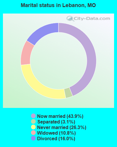
- Never married: 26.3%
- Now married: 43.9%
- Separated: 3.1%
- Widowed: 10.8%
- Divorced: 16.0%
For population 25 years and over in Lebanon:
- High school or higher: 85.6%
- Bachelor's degree or higher: 17.4%
- Graduate or professional degree: 5.6%
- Unemployed: 5.1%
- Mean travel time to work (commute): 15.2 minutes
| Here: | 9.9 |
| Missouri average: | 11.1 |
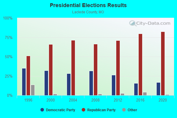
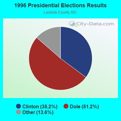
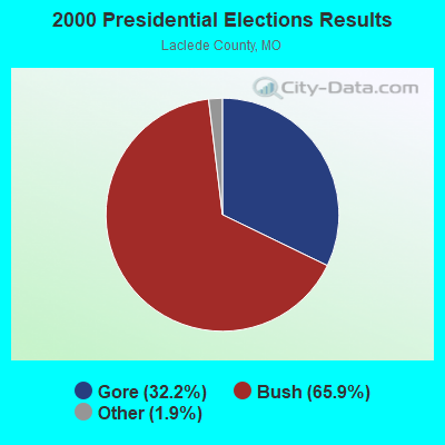

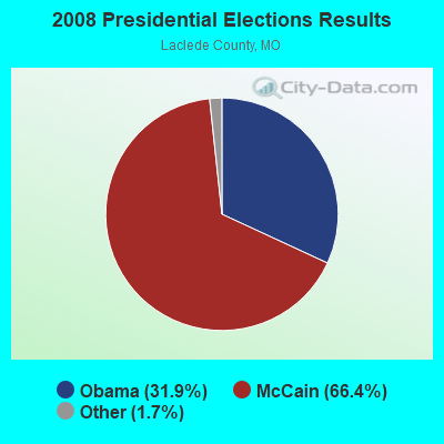
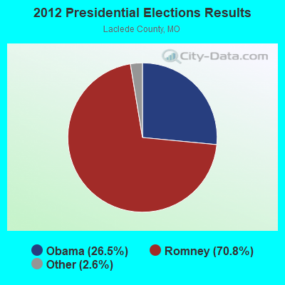
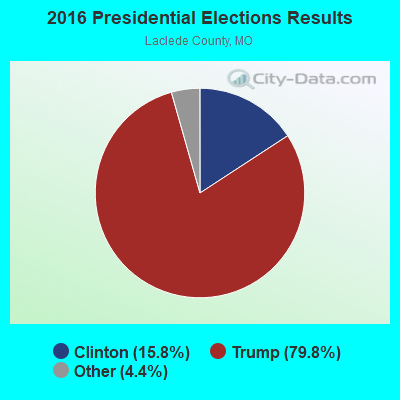
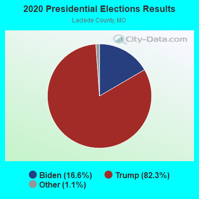
Graphs represent county-level data. Detailed 2008 Election Results
Religion statistics for Lebanon, MO (based on Laclede County data)
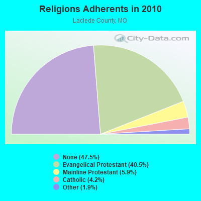
| Religion | Adherents | Congregations |
|---|---|---|
| Evangelical Protestant | 14,411 | 67 |
| Mainline Protestant | 2,090 | 13 |
| Catholic | 1,488 | 2 |
| Other | 677 | 3 |
| None | 16,905 | - |
Food Environment Statistics:
| This county: | 3.11 / 10,000 pop. |
| Missouri: | 1.88 / 10,000 pop. |
| This county: | 0.28 / 10,000 pop. |
| Missouri: | 0.18 / 10,000 pop. |
| This county: | 7.64 / 10,000 pop. |
| State: | 4.34 / 10,000 pop. |
| Laclede County: | 7.36 / 10,000 pop. |
| State: | 7.37 / 10,000 pop. |
| Laclede County: | 8.6% |
| Missouri: | 8.8% |
| This county: | 29.3% |
| Missouri: | 29.6% |
| Laclede County: | 14.4% |
| Missouri: | 13.5% |
Health and Nutrition:
| This city: | 49.2% |
| Missouri: | 50.9% |
| Lebanon: | 45.0% |
| Missouri: | 48.6% |
| This city: | 29.2 |
| Missouri: | 28.7 |
| This city: | 22.2% |
| Missouri: | 20.6% |
| This city: | 13.9% |
| Missouri: | 10.1% |
| Lebanon: | 6.8 |
| Missouri: | 6.8 |
| Lebanon: | 36.2% |
| Missouri: | 34.3% |
| Lebanon: | 54.9% |
| State: | 57.5% |
| Lebanon: | 76.6% |
| Missouri: | 79.3% |
More about Health and Nutrition of Lebanon, MO Residents
| Local government employment and payroll (March 2022) | |||||
| Function | Full-time employees | Monthly full-time payroll | Average yearly full-time wage | Part-time employees | Monthly part-time payroll |
|---|---|---|---|---|---|
| Police Protection - Officers | 30 | $116,515 | $46,606 | 0 | $0 |
| Streets and Highways | 25 | $82,937 | $39,810 | 59 | $91,450 |
| Electric Power | 22 | $96,089 | $52,412 | 0 | $0 |
| Firefighters | 16 | $79,050 | $59,288 | 2 | $2,142 |
| Parks and Recreation | 15 | $68,002 | $54,402 | 70 | $55,872 |
| Financial Administration | 13 | $58,405 | $53,912 | 0 | $0 |
| Other and Unallocable | 10 | $35,853 | $43,024 | 2 | $10,370 |
| Police - Other | 9 | $28,261 | $37,681 | 1 | $3,044 |
| Other Government Administration | 9 | $51,166 | $68,221 | 18 | $9,382 |
| Sewerage | 6 | $25,400 | $50,800 | 3 | $12,017 |
| Water Supply | 3 | $15,334 | $61,336 | 0 | $0 |
| Judicial and Legal | 1 | $3,752 | $45,024 | 3 | $25,338 |
| Totals for Government | 159 | $660,764 | $49,869 | 158 | $209,615 |
Lebanon government finances - Expenditure in 2021 (per resident):
- Construction - Regular Highways: $1,131,000 ($74.25)
Parks and Recreation: $1,115,000 ($73.20)
Sewerage: $947,000 ($62.17)
General - Other: $745,000 ($48.91)
Electric Utilities: $527,000 ($34.60)
Water Utilities: $309,000 ($20.29)
- Current Operations - Electric Utilities: $23,806,000 ($1562.89)
Police Protection: $4,266,000 ($280.07)
Central Staff Services: $2,141,000 ($140.56)
Water Utilities: $2,122,000 ($139.31)
Regular Highways: $1,586,000 ($104.12)
Sewerage: $1,567,000 ($102.88)
Parks and Recreation: $1,339,000 ($87.91)
Air Transportation: $326,000 ($21.40)
General - Other: $305,000 ($20.02)
Miscellaneous Commercial Activities - Other: $95,000 ($6.24)
- General - Interest on Debt: $165,000 ($10.83)
- Other Capital Outlay - Air Transportation: $552,000 ($36.24)
General - Other: $133,000 ($8.73)
Miscellaneous Commercial Activities - Other: $36,000 ($2.36)
Lebanon government finances - Revenue in 2021 (per resident):
- Charges - Sewerage: $26,579,000 ($1744.94)
Other: $1,618,000 ($106.22)
Air Transportation: $242,000 ($15.89)
Miscellaneous Commercial Activities: $76,000 ($4.99)
Parks and Recreation: $50,000 ($3.28)
- Miscellaneous - General Revenue - Other: $220,000 ($14.44)
Fines and Forfeits: $125,000 ($8.21)
Interest Earnings: $94,000 ($6.17)
Sale of Property: $69,000 ($4.53)
- Revenue - Electric Utilities: $25,054,000 ($1644.83)
Water Utilities: $1,822,000 ($119.62)
- State Intergovernmental - Other: $531,000 ($34.86)
Highways: $262,000 ($17.20)
General Local Government Support: $49,000 ($3.22)
Sewerage: $45,000 ($2.95)
Water Utilities: $6,000 ($0.39)
- Tax - General Sales and Gross Receipts: $8,089,000 ($531.05)
Public Utilities Sales: $1,494,000 ($98.08)
Property: $1,396,000 ($91.65)
Other: $726,000 ($47.66)
Occupation and Business License - Other: $663,000 ($43.53)
Other License: $61,000 ($4.00)
Lebanon government finances - Debt in 2021 (per resident):
- Long Term Debt - Beginning Outstanding - Public Debt for Private Purpose: $2,286,000 ($150.08)
Outstanding Nonguaranteed - Industrial Revenue: $2,264,000 ($148.63)
Retired Nonguaranteed - Public Debt for Private Purpose: $22,000 ($1.44)
Lebanon government finances - Cash and Securities in 2021 (per resident):
- Bond Funds - Cash and Securities: $1,430,000 ($93.88)
- Other Funds - Cash and Securities: $22,048,000 ($1447.48)
- Sinking Funds - Cash and Securities: $2,740,000 ($179.88)
| Businesses in Lebanon, MO | ||||
| Name | Count | Name | Count | |
|---|---|---|---|---|
| ALDI | 1 | Maurices | 1 | |
| AT&T | 1 | McDonald's | 2 | |
| Applebee's | 1 | New Balance | 1 | |
| Arby's | 1 | Nike | 3 | |
| AutoZone | 1 | Papa John's Pizza | 1 | |
| Best Western | 1 | Penske | 1 | |
| Burger King | 1 | Pizza Hut | 1 | |
| Chevrolet | 1 | Quiznos | 1 | |
| Curves | 1 | RadioShack | 1 | |
| Dairy Queen | 1 | SONIC Drive-In | 1 | |
| Days Inn | 1 | Sears | 1 | |
| Domino's Pizza | 1 | Starbucks | 1 | |
| DressBarn | 1 | Steak 'n Shake | 1 | |
| Dressbarn | 1 | Subway | 2 | |
| Famous Footwear | 1 | Super 8 | 1 | |
| FedEx | 4 | T-Mobile | 1 | |
| Ford | 1 | Taco Bell | 1 | |
| H&R Block | 1 | True Value | 1 | |
| Hardee's | 1 | U-Haul | 3 | |
| Hilton | 1 | U.S. Cellular | 2 | |
| Holiday Inn | 1 | UPS | 3 | |
| KFC | 1 | Verizon Wireless | 1 | |
| La-Z-Boy | 1 | Waffle House | 1 | |
| Lane Furniture | 1 | Walgreens | 1 | |
| Little Caesars Pizza | 1 | Walmart | 1 | |
| Long John Silver's | 1 | Wendy's | 1 | |
| Lowe's | 1 | YMCA | 1 | |
| MasterBrand Cabinets | 4 | |||
Strongest AM radio stations in Lebanon:
- KBNN (750 AM; daytime; 5 kW; LEBANON, MO; Owner: OZARK BROADCASTING, INC.)
- KLWT (1230 AM; 1 kW; LEBANON, MO; Owner: PEARSON BROADCASTING OF LEBANON, INC.)
- KRMS (1150 AM; 10 kW; OSAGE BEACH, MO; Owner: VIPER COMMUNICATIONS, INC)
- KJPW (1390 AM; 5 kW; WAYNESVILLE, MO; Owner: PULASKI COUNTY BROADCASTERS, INC.)
- KMRF (1510 AM; daytime; 5 kW; MARSHFIELD, MO; Owner: NEW LIFE EVANGELISTIC CENTER, INC.)
- WHB (810 AM; 50 kW; KANSAS CITY, MO; Owner: UNION BROADCASTING, INC.)
- KWTO (560 AM; 5 kW; SPRINGFIELD, MO; Owner: KWTO, INC.)
- KXEN (1010 AM; 50 kW; FESTUS-ST. LOUIS, MO; Owner: BDJ RADIO ENTERPRISES, LLC)
- KSGF (1260 AM; 5 kW; SPRINGFIELD, MO; Owner: JOURNAL BROADCAST CORPORATION)
- KMOX (1120 AM; 50 kW; ST. LOUIS, MO; Owner: INFINITY BROADCASTING OPERATIONS, INC.)
- KLFJ (1550 AM; 5 kW; SPRINGFIELD, MO; Owner: 127, INC.)
- KGHT (880 AM; 50 kW; SHERIDAN, AR; Owner: METROPOLITAN RADIO GROUP, INC.)
- KWOS (950 AM; 5 kW; JEFFERSON CITY, MO; Owner: ZIMMER RADIO OF MID-MISSOURI, INC.)
Strongest FM radio stations in Lebanon:
- K242AN (96.3 FM; LEBANON, MO; Owner: CURATORS OF THE UNIV. OF MISSOURI)
- KJEL (103.7 FM; LEBANON, MO; Owner: OZARK BROADCASTING, INC.)
- KTTK (90.7 FM; LEBANON, MO; Owner: LEBANON EDUCATIONAL BROADCASTING FOUNDATION)
- KCLQ (107.9 FM; LEBANON, MO; Owner: PEARSON BROADCASTING OF LEBANON, INC.)
- KTXR (101.3 FM; SPRINGFIELD, MO; Owner: STEREO BROADCASTING, INC.)
- KWFC (89.1 FM; SPRINGFIELD, MO; Owner: BAPTIST BIBLE COLLEGE, INC.)
- KXUS (97.3 FM; SPRINGFIELD, MO; Owner: CLEAR CHANNEL BROADCASTING LICENSES, INC.)
- KFBD-FM (97.9 FM; WAYNESVILLE, MO; Owner: FIDELITY BROADCASTING, INC.)
- KTTS-FM (94.7 FM; SPRINGFIELD, MO; Owner: JOURNAL BROADCAST CORPORATION)
- KCVO-FM (91.7 FM; CAMDENTON, MO; Owner: LAKE AREA EDUCATIONAL BROADCASTING FOUNDATION)
- KBFL (99.9 FM; BUFFALO, MO; Owner: MEYER-BALDRIDGE, INC.)
- KRMS-FM (93.5 FM; OSAGE BEACH, MO; Owner: VIPER COMMUNICATIONS, INC.)
- KJPW-FM (102.3 FM; WAYNESVILLE, MO; Owner: PULASKI COUNTY BROADCASTERS, INC.)
- K201AA (88.1 FM; BOLIVAR, MO; Owner: LAKE AREA EDUCATIONAL BROADCASTING FOUNDATION)
- KQUL (102.7 FM; LAKE OZARK, MO; Owner: BENNE B/CO CO. OF LAKE OZARK,INC)
TV broadcast stations around Lebanon:
- K64FQ (Channel 64; LEBANON, MO; Owner: NEW LIFE EVANGELISTIC CENTER, INC.)
- KYTV (Channel 3; SPRINGFIELD, MO; Owner: KY3, INC.)
- KSPR (Channel 33; SPRINGFIELD, MO; Owner: PIEDMONT TELEVISION OF SPRINGFIELD LICENSE LLC)
- KOLR (Channel 10; SPRINGFIELD, MO; Owner: VHR SPRINGFIELD LICENSE, INC.)
- KOZK (Channel 21; SPRINGFIELD, MO; Owner: BD. OF GOVERNORS OF SW MISSOURI STATE UNIVERSITY)
- KDEB-TV (Channel 27; SPRINGFIELD, MO; Owner: QUORUM OF MISSOURI LICENSE, LLC)
- KWBS-LP (Channel 56; SPRINGFIELD, MO; Owner: EQUITY BROADCASTING CORPORATION)
- National Bridge Inventory (NBI) Statistics
- 37Number of bridges
- 249ft / 76.0mTotal length
- $1,659,000Total costs
- 251,742Total average daily traffic
- 59,456Total average daily truck traffic
- New bridges - historical statistics
- 11900-1909
- 11920-1929
- 31930-1939
- 31950-1959
- 81970-1979
- 21980-1989
- 81990-1999
- 92000-2009
- 12010-2019
- 12020-2022
FCC Registered Antenna Towers: 346 (See the full list of FCC Registered Antenna Towers)
FCC Registered Commercial Land Mobile Towers: 2 (See the full list of FCC Registered Commercial Land Mobile Towers in Lebanon, MO)
FCC Registered Private Land Mobile Towers: 1 (See the full list of FCC Registered Private Land Mobile Towers)
FCC Registered Broadcast Land Mobile Towers: 33 (See the full list of FCC Registered Broadcast Land Mobile Towers)
FCC Registered Microwave Towers: 30 (See the full list of FCC Registered Microwave Towers in this town)
FCC Registered Paging Towers: 4 (See the full list of FCC Registered Paging Towers)
FCC Registered Maritime Coast & Aviation Ground Towers: 6 (See the full list of FCC Registered Maritime Coast & Aviation Ground Towers)
FCC Registered Amateur Radio Licenses: 172 (See the full list of FCC Registered Amateur Radio Licenses in Lebanon)
FAA Registered Aircraft Manufacturers and Dealers: 5 (See the full list of FAA Registered Manufacturers and Dealers in Lebanon)
FAA Registered Aircraft: 43 (See the full list of FAA Registered Aircraft)
2002 - 2018 National Fire Incident Reporting System (NFIRS) incidents
- Fire incident types reported to NFIRS in Lebanon, MO
- 1,13044.5%Structure Fires
- 1,08442.6%Outside Fires
- 2459.6%Mobile Property/Vehicle Fires
- 833.3%Other
 Based on the data from the years 2002 - 2018 the average number of fires per year is 150. The highest number of fires - 305 took place in 2014, and the least - 31 in 2017. The data has a declining trend.
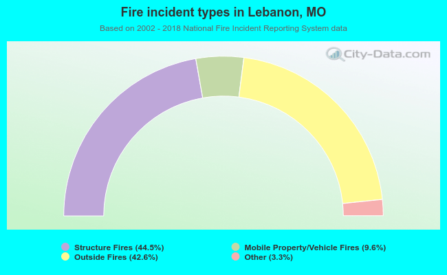 When looking into fire subcategories, the most reports belonged to: Structure Fires (44.5%), and Outside Fires (42.6%).
Fire-safe hotels and motels in Lebanon, Missouri:
- Americas Best Value Inn, 1830 W Elm St, Lebanon, Missouri 65536 , Phone: (417) 532-3133, Fax: (417) 532-8659
- Hampton Inn Lebanon, 930 Ivey Ln, Lebanon, Missouri 65536 , Phone: (417) 533-3100, Fax: (417) 533-5858
- Days Inn Lebanon, 2071 W Elm St, Lebanon, Missouri 65536 , Phone: (417) 532-7111
| Most common first names in Lebanon, MO among deceased individuals | ||
| Name | Count | Lived (average) |
|---|---|---|
| William | 186 | 74.2 years |
| James | 181 | 73.9 years |
| John | 172 | 75.1 years |
| Mary | 148 | 79.4 years |
| Robert | 130 | 72.2 years |
| Charles | 112 | 76.7 years |
| George | 87 | 79.2 years |
| Dorothy | 62 | 80.4 years |
| Ruby | 60 | 80.2 years |
| Helen | 57 | 77.6 years |
| Most common last names in Lebanon, MO among deceased individuals | ||
| Last name | Count | Lived (average) |
|---|---|---|
| Jones | 140 | 76.4 years |
| Smith | 110 | 75.8 years |
| Johnson | 74 | 77.6 years |
| Brown | 73 | 77.0 years |
| Davis | 71 | 78.0 years |
| Williams | 57 | 75.5 years |
| Moore | 51 | 74.0 years |
| Hough | 46 | 79.7 years |
| Miller | 46 | 77.3 years |
| Wilson | 45 | 80.3 years |
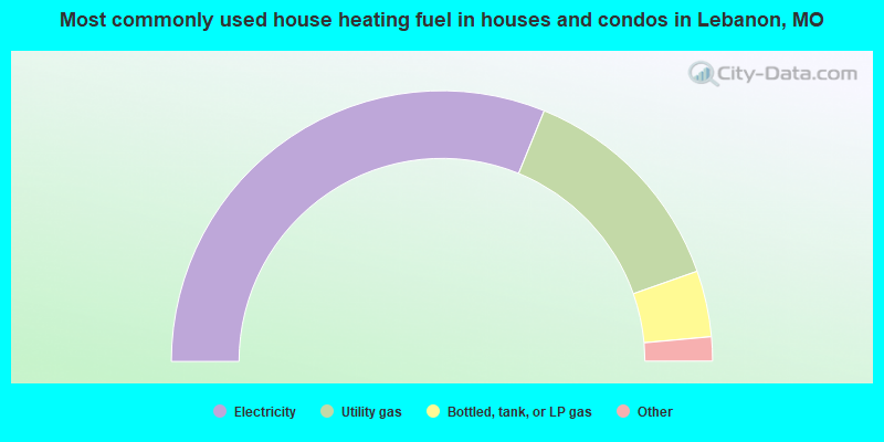
- 62.4%Electricity
- 26.9%Utility gas
- 7.9%Bottled, tank, or LP gas
- 0.9%Wood
- 0.8%Fuel oil, kerosene, etc.
- 0.8%No fuel used
- 0.3%Other fuel
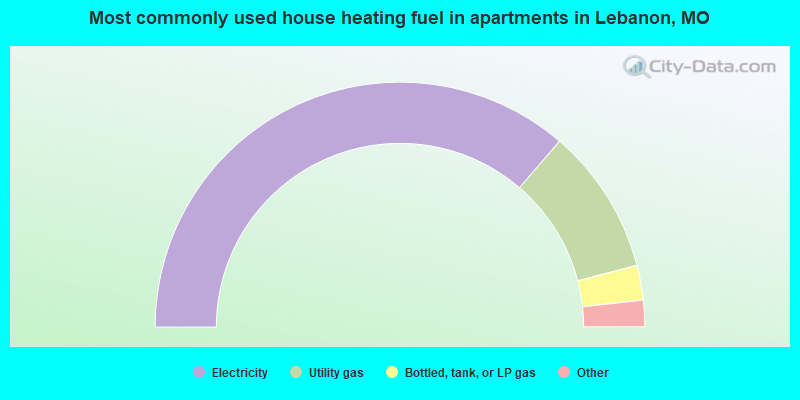
- 72.6%Electricity
- 19.3%Utility gas
- 4.6%Bottled, tank, or LP gas
- 2.5%Fuel oil, kerosene, etc.
- 0.9%No fuel used
Lebanon compared to Missouri state average:
- Unemployed percentage below state average.
- Black race population percentage significantly below state average.
- Foreign-born population percentage below state average.
- Renting percentage above state average.
- Length of stay since moving in above state average.
Lebanon on our top lists:
- #70 on the list of "Top 101 cities with largest percentage of females in occupations: production occupations (population 5,000+)"
- #89 on the list of "Top 101 cities with the most local government spending on current operations of parks and recreation per resident (population 10,000+)"
- #91 on the list of "Top 101 cities with largest percentage of females in industries: manufacturing (population 5,000+)"

|
|
Total of 23 patent applications in 2008-2024.