Littleton, Maine
Submit your own pictures of this town and show them to the world
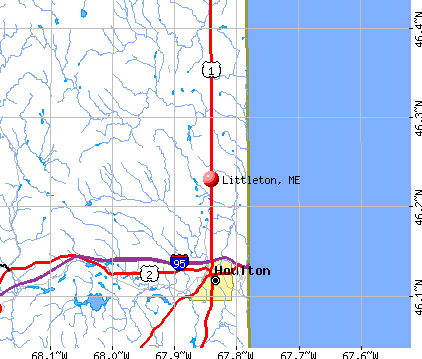
- OSM Map
- General Map
- Google Map
- MSN Map
Population change since 2000: +11.8%
 |
| Males: 556 | |
| Females: 512 |
| Median resident age: | 40.8 years |
| Maine median age: | 43.0 years |
Zip codes: 04730.
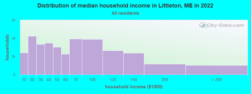
| Littleton: | $55,557 |
| ME: | $69,543 |
Estimated per capita income in 2022: $28,024 (it was $13,579 in 2000)
Littleton town income, earnings, and wages data
Estimated median house or condo value in 2022: $149,148 (it was $61,600 in 2000)
| Littleton: | $149,148 |
| ME: | $290,600 |
Mean prices in 2022: all housing units: $179,108; detached houses: $185,023; townhouses or other attached units: $218,327; in 2-unit structures: $262,505; in 3-to-4-unit structures: $121,406; in 5-or-more-unit structures: $185,084; mobile homes: $117,009; occupied boats, rvs, vans, etc.: $12,682
Detailed information about poverty and poor residents in Littleton, ME


- 97291.0%White alone
- 666.2%American Indian alone
- 171.6%Hispanic
- 100.9%Two or more races
- 30.3%Black alone
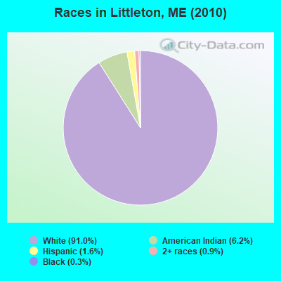
Races in Littleton detailed stats: ancestries, foreign born residents, place of birth
According to our research of Maine and other state lists, there was 1 registered sex offender living in Littleton, Maine as of April 25, 2024.
The ratio of all residents to sex offenders in Littleton is 1,068 to 1.
The ratio of registered sex offenders to all residents in this city is lower than the state average.
 Recent articles from our blog. Our writers, many of them Ph.D. graduates or candidates, create easy-to-read articles on a wide variety of topics.

 | Mass shooting in Lewiston (161 replies) |
| Maine Demographics (36 replies) |
| Full Up (12 replies) |
| Francophone Maine (65 replies) |
| Possible move to Maine husband is freaking out about bears lol (96 replies) |
| Maine weather thread (3207 replies) |
Latest news from Littleton, ME collected exclusively by city-data.com from local newspapers, TV, and radio stations
Ancestries: United States (21.8%), Irish (19.9%), English (19.6%), French (13.8%), German (6.1%), Scotch-Irish (5.1%).
Current Local Time: EST time zone
Incorporated on 03/18/1856
Elevation: 466 feet
Land area: 38.4 square miles.
Population density: 28 people per square mile (very low).
50 residents are foreign born (4.5% North America).
| This town: | 5.2% |
| Maine: | 2.9% |
| Littleton town: | 1.0% ($624) |
| Maine: | 1.5% ($1,417) |
Nearest city with pop. 50,000+: Portland, ME  (213.5 miles , pop. 64,249).
Nearest city with pop. 200,000+: Boston, MA (314.5 miles , pop. 589,141).
Nearest city with pop. 1,000,000+: Bronx, NY (479.4 miles , pop. 1,332,650).
Nearest cities:
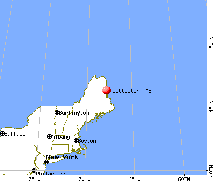
), ), )Latitude: 46.23 N, Longitude: 67.84 W
Area code commonly used in this area: 207

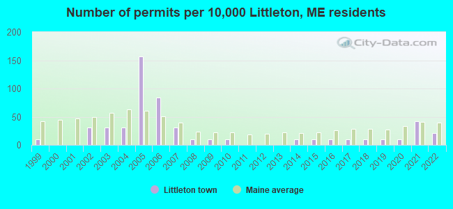
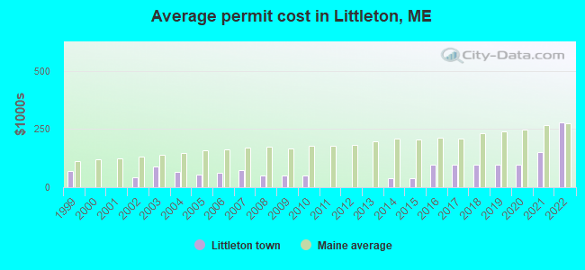
Single-family new house construction building permits:
- 2022: 2 buildings, average cost: $279,200
- 2021: 4 buildings, average cost: $150,000
- 2020: 1 building, cost: $96,000
- 2019: 1 building, cost: $96,000
- 2018: 1 building, cost: $96,000
- 2017: 1 building, cost: $96,000
- 2016: 1 building, cost: $96,000
- 2015: 1 building, cost: $40,000
- 2014: 1 building, cost: $40,000
- 2010: 1 building, cost: $50,000
- 2009: 1 building, cost: $50,000
- 2008: 1 building, cost: $50,000
- 2007: 3 buildings, average cost: $72,000
- 2006: 8 buildings, average cost: $61,100
- 2005: 15 buildings, average cost: $53,100
- 2004: 3 buildings, average cost: $67,000
- 2003: 3 buildings, average cost: $90,300
- 2002: 3 buildings, average cost: $44,200
- 1999: 1 building, cost: $70,000
| Here: | 3.3% |
| Maine: | 3.4% |

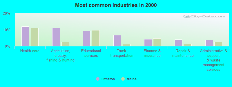
- Health care (12.1%)
- Agriculture, forestry, fishing & hunting (11.2%)
- Educational services (9.3%)
- Truck transportation (6.7%)
- Finance & insurance (4.3%)
- Repair & maintenance (4.1%)
- Administrative & support & waste management services (3.7%)
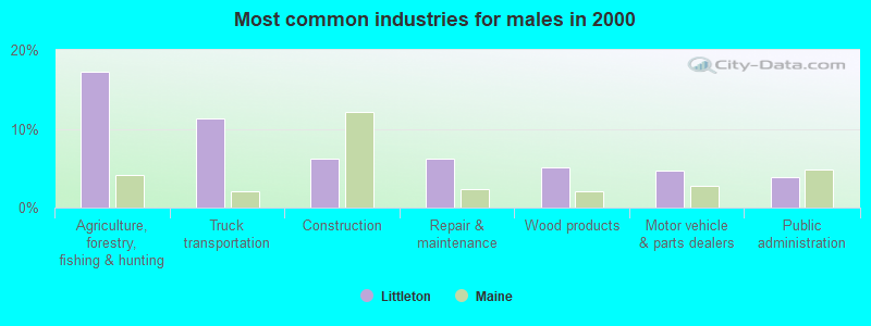
- Agriculture, forestry, fishing & hunting (17.3%)
- Truck transportation (11.4%)
- Construction (6.3%)
- Repair & maintenance (6.3%)
- Wood products (5.1%)
- Motor vehicle & parts dealers (4.7%)
- Public administration (3.9%)
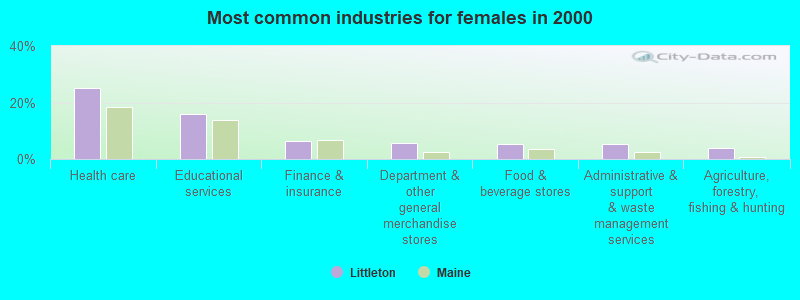
- Health care (25.0%)
- Educational services (15.9%)
- Finance & insurance (6.2%)
- Department & other general merchandise stores (5.8%)
- Food & beverage stores (5.3%)
- Administrative & support & waste management services (5.3%)
- Agriculture, forestry, fishing & hunting (3.8%)

- Driver/sales workers and truck drivers (7.8%)
- Vehicle and mobile equipment mechanics, installers, and repairers (5.2%)
- Farmers and farm managers (3.9%)
- Building and grounds cleaning and maintenance occupations (3.9%)
- Registered nurses (3.5%)
- Other production occupations, including supervisors (3.2%)
- Retail sales workers, except cashiers (3.0%)

- Driver/sales workers and truck drivers (14.1%)
- Vehicle and mobile equipment mechanics, installers, and repairers (9.4%)
- Farmers and farm managers (7.1%)
- Other production occupations, including supervisors (5.9%)
- Other material moving workers, except laborers (4.7%)
- Fishing, hunting, and forestry occupations (3.5%)
- Laborers and material movers, hand (3.1%)
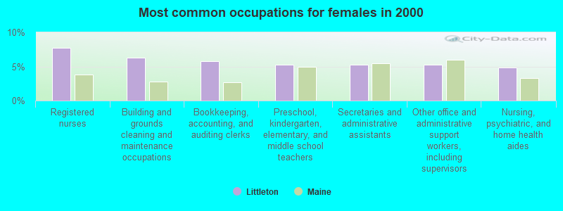
- Registered nurses (7.7%)
- Building and grounds cleaning and maintenance occupations (6.2%)
- Bookkeeping, accounting, and auditing clerks (5.8%)
- Preschool, kindergarten, elementary, and middle school teachers (5.3%)
- Secretaries and administrative assistants (5.3%)
- Other office and administrative support workers, including supervisors (5.3%)
- Nursing, psychiatric, and home health aides (4.8%)
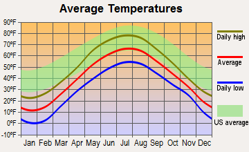
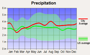
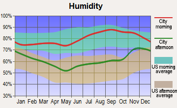
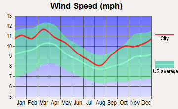
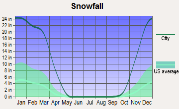
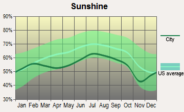
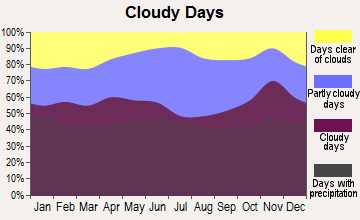
Average climate in Littleton, Maine
Based on data reported by over 4,000 weather stations
(lower is better)
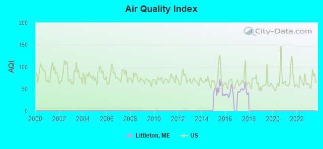
Air Quality Index (AQI) level in 2017 was 46.0. This is significantly better than average.
| City: | 46.0 |
| U.S.: | 72.6 |
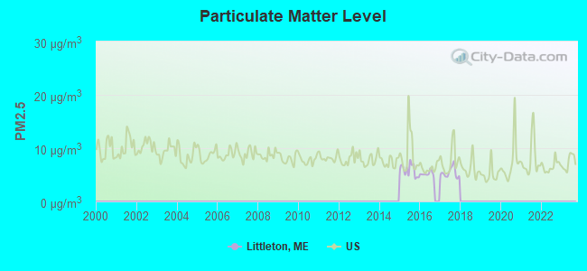
Particulate Matter (PM2.5) [µg/m3] level in 2017 was 5.39. This is significantly better than average. There were 0 monitors within city limits.
| City: | 5.39 |
| U.S.: | 8.11 |
Earthquake activity:
Littleton-area historical earthquake activity is above Maine state average. It is 86% smaller than the overall U.S. average.On 4/20/2002 at 10:50:47, a magnitude 5.3 (5.3 ML, Depth: 3.0 mi, Class: Moderate, Intensity: VI - VII) earthquake occurred 308.3 miles away from Littleton center
On 4/20/2002 at 10:50:47, a magnitude 5.2 (5.2 MB, 4.2 MS, 5.2 MW, 5.0 MW) earthquake occurred 310.0 miles away from the city center
On 7/14/2006 at 09:34:48, a magnitude 3.9 (3.9 MD, Depth: 8.6 mi, Class: Light, Intensity: II - III) earthquake occurred 60.2 miles away from the city center
On 10/16/2012 at 23:12:25, a magnitude 4.7 (4.7 ML, Depth: 10.0 mi, Class: Light, Intensity: IV - V) earthquake occurred 228.4 miles away from the city center
On 10/7/1983 at 10:18:46, a magnitude 5.3 (5.1 MB, 5.3 LG, 5.1 ML) earthquake occurred 354.3 miles away from the city center
On 1/19/1982 at 00:14:42, a magnitude 4.7 (4.5 MB, 4.7 MD, 4.5 LG) earthquake occurred 263.8 miles away from the city center
Magnitude types: regional Lg-wave magnitude (LG), body-wave magnitude (MB), duration magnitude (MD), local magnitude (ML), surface-wave magnitude (MS), moment magnitude (MW)
Natural disasters:
The number of natural disasters in Aroostook County (22) is greater than the US average (15).Major Disasters (Presidential) Declared: 13
Emergencies Declared: 9
Causes of natural disasters: Floods: 10, Storms: 8, Snows: 7, Heavy Rains: 2, Blizzard: 1, Hurricane: 1, Ice Storm: 1, Snowfall: 1, Snowstorm: 1, Wind: 1, Winter Storm: 1, Other: 2 (Note: some incidents may be assigned to more than one category).

Hospitals and medical centers near Littleton:
- HOULTON REGIONAL HOSPITAL Critical Access Hospitals (about 7 miles away; HOULTON, ME)
- THE HOULTON REG PROG CARE FAC (Nursing Home, about 7 miles away; HOULTON, ME)
- MADIGAN HOME HEALTH CARE, INC. (Home Health Center, about 8 miles away; HOULTON, ME)
- MADIGAN ESTATES (Nursing Home, about 8 miles away; HOULTON, ME)
- FOREST SPRINGS (Hospital, about 8 miles away; HOULTON, ME)
- HARMONY (Hospital, about 8 miles away; HOULTON, ME)
Colleges/universities with over 2000 students nearest to Littleton:
- University of Maine (about 101 miles; Orono, ME; Full-time enrollment: 8,931)
- Husson University (about 108 miles; Bangor, ME; FT enrollment: 2,421)
- University of Maine at Farmington (about 156 miles; Farmington, ME; FT enrollment: 2,036)
- University of Maine at Augusta (about 162 miles; Augusta, ME; FT enrollment: 3,204)
- Saint Joseph's College of Maine (about 211 miles; Standish, ME; FT enrollment: 2,010)
- Southern Maine Community College (about 214 miles; South Portland, ME; FT enrollment: 4,666)
- University of Southern Maine (about 214 miles; Portland, ME; FT enrollment: 6,647)
Points of interest:
Notable locations in Littleton: Starkey Corners (A), Littleton Station (B), Littleton Volunteer Fire Department (C). Display/hide their locations on the map
Cemeteries: Littleton Cemetery (1), Henderson Cemetery (2), Weed Cemetery (3). Display/hide their locations on the map
Lakes: Britton Lake (A), Carry Lake (B), Deep Lake (C), Long Lake (D), Monson Lake (E), Ross Lake (F). Display/hide their locations on the map
Streams, rivers, and creeks: Big Brook (A). Display/hide its location on the map
Drinking water stations with addresses in Littleton and their reported violations in the past:
WILDERNESS PINES CAMPGROUND (Population served: 220, Groundwater):Past monitoring violations:
- 14 routine major monitoring violations
- One regular monitoring violation
| This town: | 2.5 people |
| Maine: | 2.3 people |
| This town: | 69.0% |
| Whole state: | 62.9% |
| This town: | 8.6% |
| Whole state: | 9.4% |
Likely homosexual households (counted as self-reported same-sex unmarried-partner households)
- Lesbian couples: 0.5% of all households
- Gay men: 0.2% of all households
| This town: | 13.2% |
| Whole state: | 10.9% |
| This town: | 4.3% |
| Whole state: | 4.1% |
For population 15 years and over in Littleton:
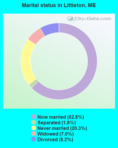
- Never married: 20.3%
- Now married: 62.8%
- Separated: 1.8%
- Widowed: 7.0%
- Divorced: 8.2%
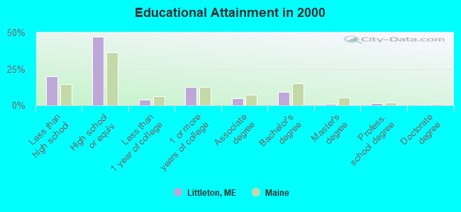
For population 25 years and over in Littleton:
- High school or higher: 80.2%
- Bachelor's degree or higher: 12.0%
- Graduate or professional degree: 2.6%
- Unemployed: 8.0%
- Mean travel time to work (commute): 21.7 minutes
| Here: | 10.4 |
| Maine average: | 11.2 |


Graphs represent county-level data. Detailed 2008 Election Results
Religion statistics for Littleton, ME (based on Aroostook County data)


| Religion | Adherents | Congregations |
|---|---|---|
| Catholic | 22,200 | 27 |
| Mainline Protestant | 5,845 | 40 |
| Evangelical Protestant | 4,411 | 51 |
| Other | 957 | 7 |
| Orthodox | 10 | 1 |
| None | 38,447 | - |
Food Environment Statistics:
| Here: | 4.03 / 10,000 pop. |
| Maine: | 2.80 / 10,000 pop. |
| This county: | 0.14 / 10,000 pop. |
| Maine: | 0.14 / 10,000 pop. |
| Aroostook County: | 2.22 / 10,000 pop. |
| Maine: | 2.20 / 10,000 pop. |
| Aroostook County: | 7.78 / 10,000 pop. |
| Maine: | 5.75 / 10,000 pop. |
| Aroostook County: | 9.17 / 10,000 pop. |
| Maine: | 11.02 / 10,000 pop. |
| Here: | 11.7% |
| Maine: | 8.2% |
| Aroostook County: | 27.6% |
| Maine: | 25.0% |
Strongest AM radio stations in Littleton:
- WREM (710 AM; daytime; 5 kW; MONTICELLO, ME; Owner: ALLAN H WEINER)
- WEGP (1390 AM; 5 kW; PRESQUE ISLE, ME; Owner: DECELLES/SMITH MEDIA, INC.)
- WFST (600 AM; 5 kW; CARIBOU, ME; Owner: NORTHERN BROADCAST MINISTRIES, INC.)
- WRKO (680 AM; 50 kW; BOSTON, MA; Owner: ENTERCOM BOSTON LICENSE, LLC)
- WZON (620 AM; 5 kW; BANGOR, ME; Owner: THE ZONE CORPORATION)
- WEEI (850 AM; 50 kW; BOSTON, MA; Owner: ENTERCOM BOSTON LICENSE, LLC)
- WCHP (760 AM; 35 kW; CHAMPLAIN, NY; Owner: CHAMPLAIN RADIO, INC.)
- WNNZ (640 AM; 50 kW; WESTFIELD, MA; Owner: CLEAR CHANNEL BROADCASTING LICENSES, INC.)
- WCRN (830 AM; 50 kW; WORCESTER, MA; Owner: CARTER BROADCASTING CORPORATION)
- WBZ (1030 AM; 50 kW; BOSTON, MA; Owner: INFINITY BROADCASTING OPERATIONS, INC.)
- WSKW (1160 AM; 10 kW; SKOWHEGAN, ME; Owner: MOUNTAIN WIRELESS, INCORPORATED)
- WABI (910 AM; 5 kW; BANGOR, ME; Owner: CLEAR CHANNEL BROADCASTING LICENSES, INC.)
- WALE (990 AM; 50 kW; GREENVILLE, RI; Owner: NORTH AMERICAN BROADCASTING CO., INC.)
Strongest FM radio stations in Littleton:
- WQHR (96.1 FM; PRESQUE ISLE, ME; Owner: CITADEL BROADCASTING COMPANY)
- WOZI (101.9 FM; PRESQUE ISLE, ME; Owner: CITADEL BROADCASTING COMPANY)
- WMEM (106.1 FM; PRESQUE ISLE, ME; Owner: MAINE PUBLIC BROADCASTING CORPORATION)
- WHOU-FM (100.1 FM; HOULTON, ME; Owner: COUNTY COMMUNICATIONS, INC.)
- WBPW (96.9 FM; PRESQUE ISLE, ME; Owner: CITADEL BROADCASTING COMPANY)
- W274AF (102.7 FM; PRESQUE ISLE, ME; Owner: BANGOR BAPTIST CHURCH)
TV broadcast stations around Littleton:
- WAGM-TV (Channel 8; PRESQUE ISLE, ME; Owner: NEPSK, INC.)
- Littleton, Maine
- Fatal accident count11
- Vehicles involved in fatal accidents23
- Fatal accidents involving drunk persons:3
- Fatalities13
- Persons involved in fatal accidents41
- Pedestrians involved in fatal accidents0
- Maine average
- Fatal accident count1828
- Vehicles involved in fatal accidents2514
- Fatal accidents involving drunk persons670
- Fatalities2025
- Persons involved in fatal accidents4352
- Pedestrians involved in fatal accidents109
- National Bridge Inventory (NBI) Statistics
- 4Number of bridges
- 26ft / 8.0mTotal length
- 457Total average daily traffic
- 49Total average daily truck traffic
- 725Total future (year 2034) average daily traffic
FCC Registered Commercial Land Mobile Towers:
1- Gillen Rd 1.6 Mi E Of Back Ridge Rd (Lat: 46.202000 Lon: -67.878361), Structure height: 0 m, Call Sign: KPN752,
Assigned Frequencies: 450.980 MHz, Grant Date: 02/02/1995, Expiration Date: 04/01/1998, Cancellation Date: 09/24/2000, Registrant: Peak Communications Inc, Houlton, ME 04730, Phone: (207) 532-6587
FCC Registered Broadcast Land Mobile Towers:
1- Town Office Us Route 1 North Road (Lat: 46.232000 Lon: -67.841972), Type: Building, Structure height: 12 m, Call Sign: WPXM284,
Assigned Frequencies: 154.965 MHz, Grant Date: 04/06/2023, Expiration Date: 05/02/2033, Certifier: Dwight Cowperthwaite, Registrant: Aroostook Technologies Inc., 4 Airport Drive, Presque Isle, ME 04769, Phone: (207) 762-9321, Fax: (207) 764-1463, Email:
FCC Registered Amateur Radio Licenses:
8 (See the full list of FCC Registered Amateur Radio Licenses in Littleton)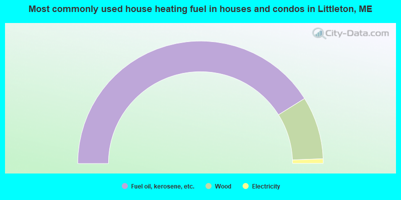
- 82.2%Fuel oil, kerosene, etc.
- 16.6%Wood
- 1.2%Electricity
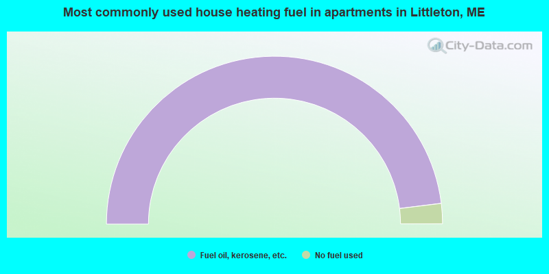
- 96.1%Fuel oil, kerosene, etc.
- 3.9%No fuel used
Littleton compared to Maine state average:
- Median house value below state average.
- Black race population percentage significantly below state average.
- Length of stay since moving in significantly above state average.
- Number of rooms per house significantly below state average.
- House age significantly below state average.
- Number of college students below state average.
- Percentage of population with a bachelor's degree or higher below state average.
Littleton on our top lists:
- #72 on the list of "Top 101 cities with the most residents born in Northern America (population 500+)"
- #72 on the list of "Top 101 cities with the most residents born in Canada (population 500+)"
- #19 on the list of "Top 101 counties with the highest carbon monoxide air pollution readings in 2012 (ppm)"
- #22 on the list of "Top 101 counties with the smallest number of children under 18 without health insurance coverage in 2000 (pop. 50,000+)"
- #29 on the list of "Top 101 counties with the lowest percentage of residents relocating from other counties between 2010 and 2011"
- #34 on the list of "Top 101 counties with the lowest percentage of residents relocating to other counties in 2011"
- #46 on the list of "Top 101 counties with the lowest Particulate Matter (PM2.5) Annual air pollution readings in 2012 (µg/m3)"