Louisville, Alabama
Submit your own pictures of this town and show them to the world
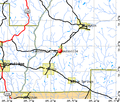
- OSM Map
- General Map
- Google Map
- MSN Map
Population change since 2000: -36.1%
 |
| Males: 196 | |
| Females: 195 |
| Median resident age: | 32.7 years |
| Alabama median age: | 39.6 years |
Zip codes: 36048.
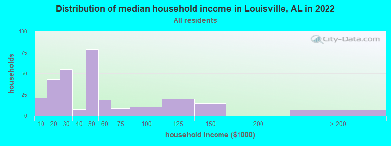
| Louisville: | $40,765 |
| AL: | $59,674 |
Estimated per capita income in 2022: $25,140 (it was $13,151 in 2000)
Louisville town income, earnings, and wages data
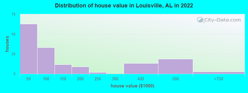
Estimated median house or condo value in 2022: $82,756 (it was $49,200 in 2000)
| Louisville: | $82,756 |
| AL: | $200,900 |
Mean prices in 2022: all housing units: $139,977; detached houses: $225,030; mobile homes: $21,837
Median gross rent in 2022: $746.
(7.4% for White Non-Hispanic residents, 39.5% for Black residents, 100.0% for Hispanic or Latino residents, 100.0% for Native Hawaiian and other Pacific Islander residents)
Detailed information about poverty and poor residents in Louisville, AL
Compare current foreclosures near Louisville, AL:
| Photo | Address | Area | Beds / Baths | Price | Details |
|---|---|---|---|---|---|

|
#1
County Road 33
Louisville, AL 36048
|
- sq. feet
|
- baths - beds |
show details | |

|
#2
Highway 51 S
Louisville, AL 36048
|
- sq. feet
|
- baths - beds |
show details | |

|
#3
County Road 9
Louisville, AL 36048
|
- sq. feet
|
- baths - beds |
show details | |

|
#4
Gerald Tew Rd
Louisville, AL 36048
|
- sq. feet
|
- baths - beds |
show details | |

|
#5
County Road 20
Louisville, AL 36048
|
- sq. feet
|
- baths - beds |
show details | |

|
#6
Mcgilvary Rd
Louisville, AL 36048
|
1,080 sq. feet
|
- baths - beds |
show details | |

|
#7
Victoria St
Louisville, AL 36048
|
- sq. feet
|
- baths - beds |
show details | |

|
#8
St Luke Church Rd
Louisville, AL 36048
|
- sq. feet
|
- baths - beds |
show details | |

|
#9
Blue Springs Rd
Louisville, AL 36048
|
1,080 sq. feet
|
- baths - beds |
show details | |

|
#10
Beaty Dr
Louisville, AL 36048
|
- sq. feet
|
- baths - beds |
show details |
| Photo | Address | Area | Beds / Baths | Price | Details |
|---|---|---|---|---|---|

|
#11
County Road 19
Louisville, AL 36048
|
- sq. feet
|
- baths - beds |
show details | |

|
#12
County Road 75 N
Clopton, AL 36317
|
- sq. feet
|
- baths - beds |
show details | |

|
#13
E End Cir
Brundidge, AL 36010
|
- sq. feet
|
- baths - beds |
show details | |

|
#14
Crawley Dr
Brundidge, AL 36010
|
- sq. feet
|
- baths - beds |
show details | |

|
#15
County Road 323
Skipperville, AL 36374
|
- sq. feet
|
- baths - beds |
show details | |

|
#16
County Road 75 N
Clopton, AL 36317
|
- sq. feet
|
- baths - beds |
show details | |

|
#17
County Road 79 S
Eufaula, AL 36027
|
1,734 sq. feet
|
- baths - beds |
show details | |

|
#18
County Road 4
Troy, AL 36081
|
- sq. feet
|
- baths - beds |
show details | |

|
#19
Lawson St
Brundidge, AL 36010
|
- sq. feet
|
- baths - beds |
show details | |

|
#20
Highway 51
Ariton, AL 36311
|
912 sq. feet
|
- baths - beds |
show details |
| Photo | Address | Area | Beds / Baths | Price | Details |
|---|---|---|---|---|---|

|
#21
County Road 6642
Brundidge, AL 36010
|
- sq. feet
|
- baths - beds |
show details | |

|
#22
County Road 6642
Banks, AL 36005
|
- sq. feet
|
- baths - beds |
show details | |

|
#23
Tennille Rd
Brundidge, AL 36010
|
- sq. feet
|
- baths - beds |
show details | |

|
#24
Highway 105
Clopton, AL 36317
|
- sq. feet
|
- baths - beds |
show details | |

|
#25
County Road 4421
Brundidge, AL 36010
|
- sq. feet
|
- baths - beds |
show details | |

|
#26
River Rd
Ariton, AL 36311
|
1,125 sq. feet
|
- baths - beds |
show details | |

|
#27
Highway 30
Clayton, AL 36016
|
- sq. feet
|
- baths - beds |
show details | |

|
#28
County Road 4420
Brundidge, AL 36010
|
- sq. feet
|
- baths - beds |
show details | |

|
#29
Mary Person Rd
Midway, AL 36053
|
- sq. feet
|
- baths - beds |
show details | |

|
#30
Pea River Rd
Ariton, AL 36311
|
- sq. feet
|
- baths - beds |
show details |
| Photo | Address | Area | Beds / Baths | Price | Details |
|---|---|---|---|---|---|

|
#31
County Road 37
Skipperville, AL 36374
|
- sq. feet
|
- baths - beds |
show details | |

|
#32
Mary Person Rd
Midway, AL 36053
|
- sq. feet
|
- baths - beds |
show details | |

|
#33
County Road 4420
Brundidge, AL 36010
|
- sq. feet
|
- baths - beds |
show details | |

|
#34
Dry Creek Rd
Midway, AL 36053
|
1,368 sq. feet
|
- baths - beds |
show details | |

|
#35
County Road 75 N
Clopton, AL 36317
|
888 sq. feet
|
- baths - beds |
show details | |

|
#36
County Road 58
Clopton, AL 36317
|
- sq. feet
|
- baths - beds |
show details | |

|
#37
E Troy St
Brundidge, AL 36010
|
1,491 sq. feet
|
- baths - beds |
show details | |

|
#38
Creel Richardson Rd
Ariton, AL 36311
|
- sq. feet
|
- baths - beds |
show details | |

|
#39
Lee St
Brundidge, AL 36010
|
- sq. feet
|
- baths - beds |
show details | |

|
#40
Pine Valley Est
Brundidge, AL 36010
|
- sq. feet
|
- baths - beds |
show details |
| Photo | Address | Area | Beds / Baths | Price | Details |
|---|---|---|---|---|---|

|
#41
County Road 15
Ozark, AL 36360
|
- sq. feet
|
- baths - beds |
show details | |

|
#42
Antioch Church Rd
Midway, AL 36053
|
- sq. feet
|
- baths - beds |
show details | |

|
#43
County Road 33
Ozark, AL 36360
|
1,050 sq. feet
|
- baths - beds |
show details | |

|
#44
N Highway 123
Ariton, AL 36311
|
- sq. feet
|
- baths - beds |
show details | |

|
#45
County Road 120
Ariton, AL 36311
|
- sq. feet
|
- baths - beds |
show details | |

|
#46
Highway 131
Eufaula, AL 36027
|
- sq. feet
|
- baths - beds |
show details | |

|
#47
Johnson Ave
Brundidge, AL 36010
|
1,519 sq. feet
|
- baths - beds |
show details | |

|
#48
S And M Rd
Midway, AL 36053
|
- sq. feet
|
- baths - beds |
show details | |

|
#49
Bryant St
Brundidge, AL 36010
|
1,066 sq. feet
|
- baths - beds |
show details | |

|
Check over 1 million property listings on Foreclosure.com!
|
browse all offers | |||


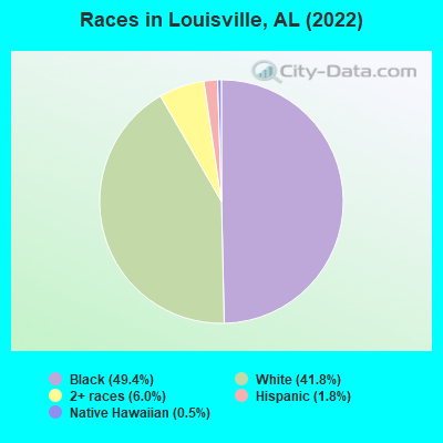
- 30549.4%Black alone
- 25841.8%White alone
- 376.0%Two or more races
- 111.8%Hispanic
- 30.5%Native Hawaiian and Other
Pacific Islander alone
According to our research of Alabama and other state lists, there were 8 registered sex offenders living in Louisville, Alabama as of April 28, 2024.
The ratio of all residents to sex offenders in Louisville is 60 to 1.
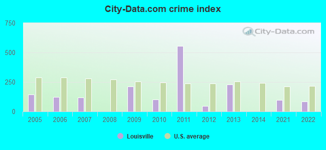
Type |
2009 |
2010 |
2011 |
2012 |
2013 |
2014 |
2021 |
2022 |
|---|---|---|---|---|---|---|---|---|
| Murders (per 100,000) | 0 (0.0) | 0 (0.0) | 0 (0.0) | 0 (0.0) | 0 (0.0) | 0 (0.0) | 0 (0.0) | 0 (0.0) |
| Rapes (per 100,000) | 1 (178.6) | 0 (0.0) | 2 (383.9) | 0 (0.0) | 1 (200.0) | 0 (0.0) | 0 (0.0) | 0 (0.0) |
| Robberies (per 100,000) | 0 (0.0) | 0 (0.0) | 1 (191.9) | 0 (0.0) | 0 (0.0) | 0 (0.0) | 0 (0.0) | 0 (0.0) |
| Assaults (per 100,000) | 0 (0.0) | 1 (192.7) | 2 (383.9) | 1 (194.6) | 0 (0.0) | 0 (0.0) | 2 (442.5) | 1 (258.4) |
| Burglaries (per 100,000) | 2 (357.1) | 3 (578.0) | 8 (1,536) | 0 (0.0) | 2 (400.0) | 0 (0.0) | 0 (0.0) | 0 (0.0) |
| Thefts (per 100,000) | 4 (714.3) | 3 (578.0) | 1 (191.9) | 1 (194.6) | 5 (1,000) | 0 (0.0) | 1 (221.2) | 3 (775.2) |
| Auto thefts (per 100,000) | 1 (178.6) | 0 (0.0) | 0 (0.0) | 0 (0.0) | 0 (0.0) | 0 (0.0) | 0 (0.0) | 0 (0.0) |
| Arson (per 100,000) | 0 (0.0) | 0 (0.0) | 0 (0.0) | 0 (0.0) | 0 (0.0) | 0 (0.0) | 0 (0.0) | 0 (0.0) |
| City-Data.com crime index | 210.7 | 102.1 | 556.6 | 46.7 | 228.0 | 0.0 | 97.3 | 82.7 |
The City-Data.com crime index weighs serious crimes and violent crimes more heavily. Higher means more crime, U.S. average is 246.1. It adjusts for the number of visitors and daily workers commuting into cities.
Crime rate in Louisville detailed stats: murders, rapes, robberies, assaults, burglaries, thefts, arson
Full-time law enforcement employees in 2021, including police officers: 1 (1 officers - 1 male; 0 female).
| Officers per 1,000 residents here: | 2.21 |
| Alabama average: | 2.40 |
 Recent articles from our blog. Our writers, many of them Ph.D. graduates or candidates, create easy-to-read articles on a wide variety of topics.

 | New York Times Article comparing Birmingham and Nashville (121 replies) |
| UPDATED: New and Upcoming Projects. (3721 replies) |
| Beautiful Birmingham (72 replies) |
| Another soccer club coming to Birmingham (82 replies) |
| Huntsville/Madison Development News (6673 replies) |
| Toll bridge (46 replies) |
Latest news from Louisville, AL collected exclusively by city-data.com from local newspapers, TV, and radio stations
Ancestries: American (33.8%), Irish (5.0%), European (2.3%).
Current Local Time: CST time zone
Elevation: 556 feet
Land area: 2.75 square miles.
Population density: 142 people per square mile (very low).
9 residents are foreign born
| This town: | 1.5% |
| Alabama: | 3.5% |
| Louisville town: | 0.4% ($199) |
| Alabama: | 0.4% ($289) |
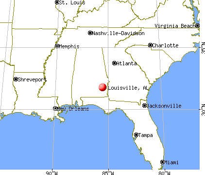
Nearest city with pop. 50,000+: Dothan, AL  (39.3 miles , pop. 57,737).
Nearest city with pop. 200,000+: Montgomery, AL (58.4 miles , pop. 201,568).
Nearest city with pop. 1,000,000+: Houston, TX (600.1 miles , pop. 1,953,631).
Nearest cities:
), ), ), ), )Latitude: 31.78 N, Longitude: 85.56 W
Area code: 334
Single-family new house construction building permits:
- 2004: 1 building, cost: $100,000
| Here: | 4.5% |
| Alabama: | 2.6% |
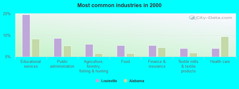
- Educational services (19.6%)
- Public administration (8.6%)
- Agriculture, forestry, fishing & hunting (5.7%)
- Food (5.3%)
- Finance & insurance (5.3%)
- Textile mills & textile products (3.8%)
- Health care (3.8%)
- Educational services (13.2%)
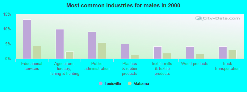
- Agriculture, forestry, fishing & hunting (9.9%)
- Public administration (9.1%)
- Plastics & rubber products (5.0%)
- Textile mills & textile products (4.1%)
- Wood products (4.1%)
- Truck transportation (4.1%)
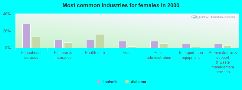
- Educational services (28.4%)
- Finance & insurance (9.1%)
- Health care (9.1%)
- Food (8.0%)
- Public administration (8.0%)
- Transportation equipment (4.5%)
- Administrative & support & waste management services (4.5%)
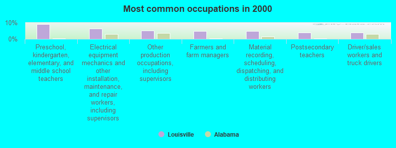
- Preschool, kindergarten, elementary, and middle school teachers (9.1%)
- Electrical equipment mechanics and other installation, maintenance, and repair workers, including supervisors (6.2%)
- Other production occupations, including supervisors (5.3%)
- Farmers and farm managers (4.8%)
- Material recording, scheduling, dispatching, and distributing workers (4.8%)
- Postsecondary teachers (3.8%)
- Driver/sales workers and truck drivers (3.8%)
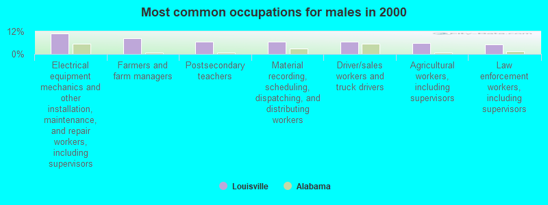
- Electrical equipment mechanics and other installation, maintenance, and repair workers, including supervisors (10.7%)
- Farmers and farm managers (8.3%)
- Postsecondary teachers (6.6%)
- Material recording, scheduling, dispatching, and distributing workers (6.6%)
- Driver/sales workers and truck drivers (6.6%)
- Agricultural workers, including supervisors (5.8%)
- Law enforcement workers, including supervisors (5.0%)

- Preschool, kindergarten, elementary, and middle school teachers (19.3%)
- Other production occupations, including supervisors (6.8%)
- Food processing workers (6.8%)
- Cooks and food preparation workers (5.7%)
- Information and record clerks, except customer service representatives (5.7%)
- Financial managers (4.5%)
- Personal appearance workers (4.5%)
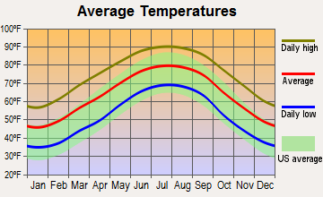
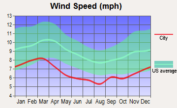
Average climate in Louisville, Alabama
Based on data reported by over 4,000 weather stations


(lower is better)
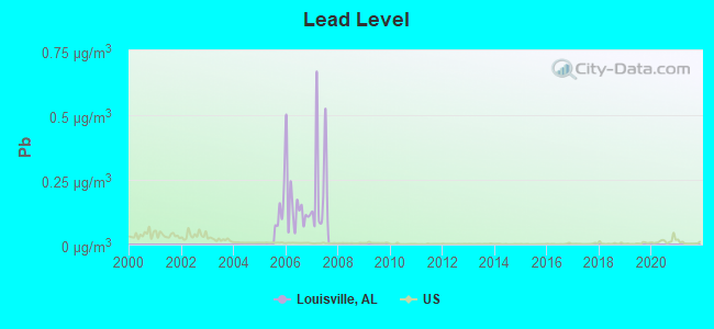
Lead (Pb) [µg/m3] level in 2007 was 0.230. This is significantly worse than average. Closest monitor was 24.9 miles away from the city center.
| City: | 0.230 |
| U.S.: | 0.009 |
Tornado activity:
Louisville-area historical tornado activity is slightly below Alabama state average. It is 45% greater than the overall U.S. average.
On 3/2/1971, a category F3 (max. wind speeds 158-206 mph) tornado 3.6 miles away from the Louisville town center caused between $5000 and $50,000 in damages.
On 11/25/1986, a category F3 tornado 9.3 miles away from the town center injured 4 people and caused between $500,000 and $5,000,000 in damages.
Earthquake activity:
Louisville-area historical earthquake activity is significantly above Alabama state average. It is 27% greater than the overall U.S. average.On 10/24/1997 at 08:35:17, a magnitude 4.9 (4.8 MB, 4.2 MS, 4.9 LG, Depth: 6.2 mi, Class: Light, Intensity: IV - V) earthquake occurred 110.9 miles away from the city center
On 1/18/1999 at 07:00:53, a magnitude 4.8 (4.8 MB, 4.0 LG, Depth: 0.6 mi) earthquake occurred 149.7 miles away from Louisville center
On 4/29/2003 at 08:59:39, a magnitude 4.9 (4.4 MB, 4.6 MW, 4.9 LG) earthquake occurred 187.7 miles away from Louisville center
On 8/2/1974 at 08:52:09, a magnitude 4.9 (4.3 MB, 4.9 LG) earthquake occurred 229.7 miles away from Louisville center
On 4/29/2003 at 08:59:39, a magnitude 4.6 (4.6 MW, Depth: 12.3 mi) earthquake occurred 187.7 miles away from the city center
On 6/24/1975 at 11:11:36, a magnitude 4.5 (4.5 MB) earthquake occurred 188.7 miles away from the city center
Magnitude types: regional Lg-wave magnitude (LG), body-wave magnitude (MB), surface-wave magnitude (MS), moment magnitude (MW)
Natural disasters:
The number of natural disasters in Barbour County (20) is greater than the US average (15).Major Disasters (Presidential) Declared: 13
Emergencies Declared: 5
Causes of natural disasters: Storms: 11, Floods: 8, Tornadoes: 7, Hurricanes: 6, Winds: 3, Drought: 1, Snowfall: 1, Tropical Storm: 1, Winter Storm: 1, Other: 1 (Note: some incidents may be assigned to more than one category).

Heliports located in Louisville:
Colleges/universities with over 2000 students nearest to Louisville:
- Troy University (about 24 miles; Troy, AL; Full-time enrollment: 16,148)
- George C Wallace State Community College-Dothan (about 33 miles; Dothan, AL; FT enrollment: 3,611)
- Enterprise State Community College (about 38 miles; Enterprise, AL; FT enrollment: 2,101)
- Tuskegee University (about 46 miles; Tuskegee, AL; FT enrollment: 2,810)
- Auburn University at Montgomery (about 55 miles; Montgomery, AL; FT enrollment: 4,092)
- Auburn University (about 57 miles; Auburn University, AL; FT enrollment: 22,741)
- Faulkner University (about 57 miles; Montgomery, AL; FT enrollment: 2,887)
Public elementary/middle schools in Louisville:
- BARBOUR CO INTERMEDIATE SCH (Students: 235, Location: 81 VICTORIA STREET, Grades: 3-6)
- BARBOUR CO PRIMARY SCH (Location: 81 VICTORIA STREET, Grades: PK-2)
Points of interest:
Notable location: Louisville Fire and Rescue (A). Display/hide its location on the map
Drinking water stations with addresses in Louisville that have no violations reported:
- LOUISVILLE WATER WORKS (Population served: 1,380, Primary Water Source Type: Groundwater)
| This town: | 2.5 people |
| Alabama: | 2.5 people |
| This town: | 73.1% |
| Whole state: | 67.8% |
| This town: | 5.3% |
| Whole state: | 4.7% |
Likely homosexual households (counted as self-reported same-sex unmarried-partner households)
- Lesbian couples: 1.0% of all households
- Gay men: 0.0% of all households
Banks with branches in Louisville (2011 data):
- Farmers Exchange Bank: at 1920 Main Street, branch established on 1917/01/01. Info updated 2006/11/03: Bank assets: $188.8 mil, Deposits: $174.3 mil, local headquarters, negative income in the last year, Commercial Lending Specialization, 4 total offices, Holding Company: Feb Bancshares, Inc.
For population 15 years and over in Louisville:
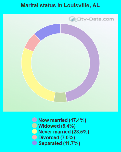
- Never married: 28.5%
- Now married: 47.4%
- Separated: 11.7%
- Widowed: 5.4%
- Divorced: 7.0%
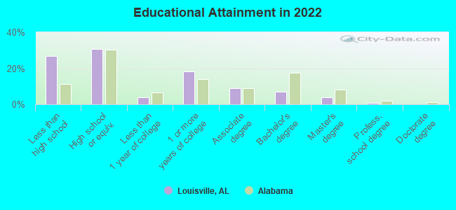
For population 25 years and over in Louisville:
- High school or higher: 70.7%
- Bachelor's degree or higher: 10.7%
- Graduate or professional degree: 4.3%
- Unemployed: 2.3%
- Mean travel time to work (commute): 13.3 minutes
| Here: | 9.2 |
| Alabama average: | 11.5 |
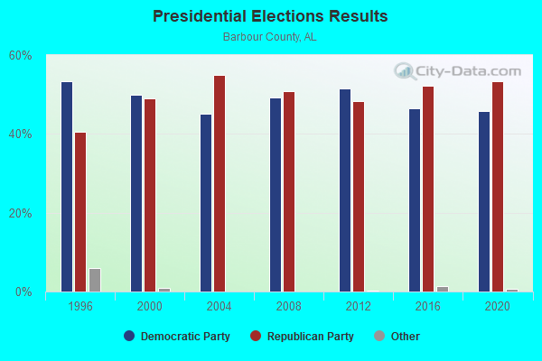
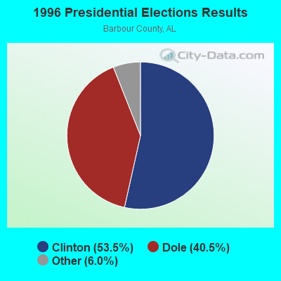
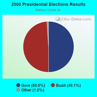
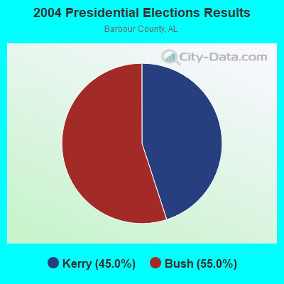
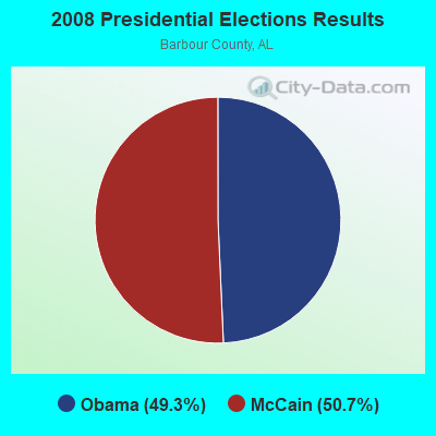
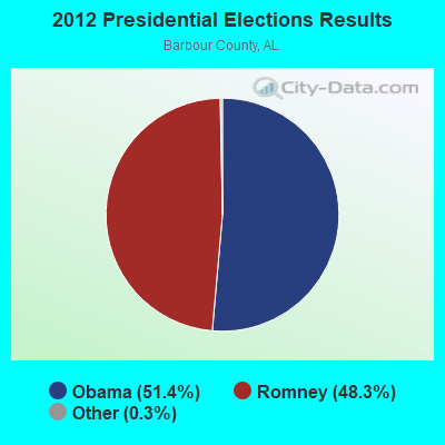
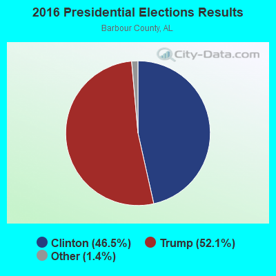
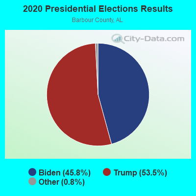
Graphs represent county-level data. Detailed 2008 Election Results
Religion statistics for Louisville, AL (based on Barbour County data)
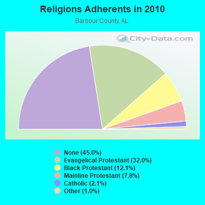
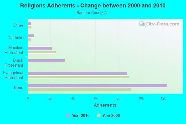
| Religion | Adherents | Congregations |
|---|---|---|
| Evangelical Protestant | 8,793 | 51 |
| Black Protestant | 3,328 | 21 |
| Mainline Protestant | 2,140 | 14 |
| Catholic | 575 | 1 |
| Other | 265 | 2 |
| None | 12,356 | - |
Food Environment Statistics:
| Barbour County: | 2.04 / 10,000 pop. |
| Alabama: | 1.89 / 10,000 pop. |
| Barbour County: | 0.68 / 10,000 pop. |
| Alabama: | 0.65 / 10,000 pop. |
| Barbour County: | 6.45 / 10,000 pop. |
| State: | 6.32 / 10,000 pop. |
| This county: | 3.73 / 10,000 pop. |
| Alabama: | 5.75 / 10,000 pop. |
| This county: | 13.0% |
| State: | 11.8% |
| Barbour County: | 36.4% |
| Alabama: | 31.7% |
| This county: | 20.8% |
| Alabama: | 13.5% |
Health and Nutrition:
| Louisville: | 45.7% |
| State: | 49.0% |
| This city: | 40.3% |
| Alabama: | 45.7% |
| Louisville: | 28.9 |
| Alabama: | 28.9 |
| Here: | 22.6% |
| State: | 20.7% |
| Louisville: | 11.8% |
| Alabama: | 11.0% |
| Louisville: | 6.8 |
| Alabama: | 6.8 |
| This city: | 32.6% |
| Alabama: | 34.4% |
| This city: | 49.9% |
| Alabama: | 55.2% |
| This city: | 76.1% |
| Alabama: | 79.3% |
More about Health and Nutrition of Louisville, AL Residents
| Local government employment and payroll (March 2022) | |||||
| Function | Full-time employees | Monthly full-time payroll | Average yearly full-time wage | Part-time employees | Monthly part-time payroll |
|---|---|---|---|---|---|
| Other Government Administration | 6 | $350 | $700 | 0 | $0 |
| Police Protection - Officers | 2 | $7,529 | $45,174 | 1 | $1,010 |
| Financial Administration | 1 | $3,543 | $42,516 | 0 | $0 |
| Streets and Highways | 0 | $0 | 3 | $3,100 | |
| Solid Waste Management | 0 | $0 | 3 | $3,100 | |
| Totals for Government | 9 | $11,421 | $15,228 | 7 | $7,210 |
Louisville government finances - Expenditure in 2017 (per resident):
- Construction - Parks and Recreation: $58,000 ($148.34)
General Public Buildings: $3,000 ($7.67)
- Current Operations - Water Utilities: $155,000 ($396.42)
Police Protection: $118,000 ($301.79)
Solid Waste Management: $42,000 ($107.42)
Central Staff Services: $36,000 ($92.07)
Sewerage: $30,000 ($76.73)
Libraries: $2,000 ($5.12)
Parks and Recreation: $2,000 ($5.12)
- Other Capital Outlay - Parks and Recreation: $3,000 ($7.67)
- Total Salaries and Wages: $36,000 ($92.07)
- Water Utilities - Interest on Debt: $29,000 ($74.17)
Louisville government finances - Revenue in 2017 (per resident):
- Charges - Solid Waste Management: $51,000 ($130.43)
Sewerage: $38,000 ($97.19)
Other: $1,000 ($2.56)
- Federal Intergovernmental - Public Welfare: $6,000 ($15.35)
- Miscellaneous - General Revenue - Other: $35,000 ($89.51)
Rents: $10,000 ($25.58)
- Revenue - Water Utilities: $156,000 ($398.98)
- State Intergovernmental - Highways: $6,000 ($15.35)
Other: $1,000 ($2.56)
- Tax - General Sales and Gross Receipts: $123,000 ($314.58)
Occupation and Business License - Other: $75,000 ($191.82)
Property: $41,000 ($104.86)
Motor Fuels Sales: $14,000 ($35.81)
Tobacco Products Sales: $9,000 ($23.02)
Alcoholic Beverage Sales: $9,000 ($23.02)
Public Utilities Sales: $1,000 ($2.56)
Individual Income: $1,000 ($2.56)
Louisville government finances - Debt in 2017 (per resident):
- Long Term Debt - Beginning Outstanding - Unspecified Public Purpose: $1,131,000 ($2892.58)
Outstanding Unspecified Public Purpose: $1,131,000 ($2892.58)
Louisville government finances - Cash and Securities in 2017 (per resident):
- Other Funds - Cash and Securities: $242,000 ($618.93)
- Sinking Funds - Cash and Securities: $400,000 ($1023.02)
Strongest AM radio stations in Louisville:
- WQLS (1200 AM; 10 kW; OZARK, AL; Owner: STYLES BROADCASTING OF DOTHAN, INC.)
- WTBF (970 AM; 5 kW; TROY, AL; Owner: TROY BROADCASTING CORP.)
- WOOF (560 AM; 5 kW; DOTHAN, AL; Owner: WOOF, INC.)
- WMSP (740 AM; 10 kW; MONTGOMERY, AL; Owner: CUMULUS LICENSING CORP.)
- WJOX (690 AM; 50 kW; BIRMINGHAM, AL; Owner: CITADEL BROADCASTING COMPANY)
- WGST (640 AM; 50 kW; ATLANTA, GA; Owner: CITICASTERS LICENSES, L.P.)
- WMAC (940 AM; 50 kW; MACON, GA; Owner: CUMULUS LICENSING CORP.)
- WDAK (540 AM; 5 kW; COLUMBUS, GA; Owner: CLEAR CHANNEL BROADCASTING LICENSES, INC.)
- WNSI (810 AM; 50 kW; JACKSONVILLE, AL; Owner: UNITED BROADCASTING NETWORK, INC.)
- WDJC (850 AM; 50 kW; BIRMINGHAM, AL; Owner: KIMTRON, INC.)
- WSTT (730 AM; 25 kW; THOMASVILLE, GA; Owner: MARION R. WILLIAMS)
- WASG (550 AM; 25 kW; ATMORE, AL; Owner: 550 AM, INC)
- WKNG (1060 AM; daytime; 50 kW; TALLAPOOSA, GA; Owner: WKNG, INC.)
Strongest FM radio stations in Louisville:
- WQLD (104.3 FM; LUVERNE, AL; Owner: CAPSTAR TX LIMITED PARTNERSHIP)
- WZHT (105.7 FM; TROY, AL; Owner: CAPSTAR TX LIMITED PARTNERSHIP)
- WKMX (106.7 FM; ENTERPRISE, AL; Owner: WKMX, INC.)
- WTBF-FM (94.7 FM; BRUNDIDGE, AL; Owner: TROY BROADCASTING CORPORATION)
- WLWI-FM (92.3 FM; MONTGOMERY, AL; Owner: CUMULUS LICENSING CORP.)
- WTVY-FM (95.5 FM; DOTHAN, AL; Owner: STYLES BROADCASTING OF DOTHAN, INC.)
- WIOL (92.7 FM; EUFAULA, AL; Owner: HATCHEE CREEK COMMUNICATIONS, INC.)
- WTSU (89.9 FM; MONTGOMERY-TROY, AL; Owner: TROY STATE UNIVERSITY)
- WAXU (91.1 FM; TROY, AL; Owner: AMERICAN FAMILY ASSOCIATION)
- WOOF-FM (99.7 FM; DOTHAN, AL; Owner: WOOF, INC.)
- WZTZ (101.1 FM; ELBA, AL; Owner: ELBA RADIO COMPANY)
- WAQG (91.7 FM; OZARK, AL; Owner: AMERICAN FAMILY ASSOCIATION)
- WDYF (90.3 FM; DOTHAN, AL; Owner: FAITH BROADCASTING, INC.)
- WIZB (94.3 FM; ABBEVILLE, AL; Owner: CELEBRATIONS COMMUNICATIONS COMPANY, INC.)
- W220BI (91.9 FM; EUFAULA, AL; Owner: MONTGOMERY CHRISTIAN EDUC., RADIO)
TV broadcast stations around Louisville:
- WGIQ (Channel 43; LOUISVILLE, AL; Owner: ALABAMA EDUCATIONAL TELEVISION COMMISSION)
- WRJM-TV (Channel 67; TROY, AL; Owner: JOSIE PARK BROADCASTING, INC.)
- WSFA (Channel 12; MONTGOMERY, AL; Owner: LIBCO, INC.)
- WCOV-TV (Channel 20; MONTGOMERY, AL; Owner: WOODS COMMUNICATIONS CORPORATION)
- WNCF (Channel 32; MONTGOMERY, AL; Owner: CHANNEL 32 MONTGOMERY LLC)
- WTVY (Channel 4; DOTHAN, AL; Owner: GRAY MIDAMERICA TV LICENSEE CORP.)
- WDFX-TV (Channel 34; OZARK, AL; Owner: WAITT LICENSE CO. OF ALABAMA, L.L.C.)
Louisville fatal accident list:
Jan 10, 1992 10:35 PM, 51, Vehicles: 2, Persons: 3, Fatalities: 1, Drunk persons involved: 1
Oct 20, 1984 06:00 AM, 51, Vehicles: 1, Persons: 4, Fatalities: 2
- National Bridge Inventory (NBI) Statistics
- 8Number of bridges
- 98ft / 29.9mTotal length
- $8,397,000Total costs
- 4,444Total average daily traffic
- 395Total average daily truck traffic
- 6,063Total future (year 2032) average daily traffic
FCC Registered Antenna Towers:
22 (See the full list of FCC Registered Antenna Towers in Louisville)FCC Registered Broadcast Land Mobile Towers:
2- Lat: 31.774167 Lon: -85.563333, Call Sign: WPYM757,
Assigned Frequencies: 463.825 MHz, Grant Date: 09/10/2003, Expiration Date: 09/10/2013, Cancellation Date: 11/16/2013, Certifier: Steve Baxter, Registrant: Ward Bell Communications, 232 Ross Clark Circle, Dothan, AL 36303, Phone: (334) 794-3777, Fax: (334) 793-5349
- Lat: 31.774333 Lon: -85.563194, Call Sign: WRDJ833,
Assigned Frequencies: 463.825 MHz, 464.887 MHz, 469.862 MHz, 469.887 MHz, 469.950 MHz, Grant Date: 05/16/2019, Expiration Date: 05/16/2029, Certifier: Mark Green, Registrant: Mobile Communications America, 232 Ross Clark Circle, Dothan, AL 36303, Phone: (334) 794-3777, Email:
FCC Registered Microwave Towers:
3- BARBOUR IS, Barbour County Ms, 18 Beaty Dr. (Lat: 31.780639 Lon: -85.553889), Type: Pole, Structure height: 36.6 m, Overall height: 38.1 m, Call Sign: WQWW593,
Assigned Frequencies: 11525.0 MHz, 11525.0 MHz, 11525.0 MHz, Grant Date: 12/09/2015, Expiration Date: 12/09/2025, Certifier: Jeffrey R Strenkowski, Registrant: Uniti Group Inc., 335 Jeanette Barrett Industrial Blvd, Wetumpka, AL 36092, Phone: (501) 458-4397, Email:
- 9AT2702H, 24 Planer Mill Road (Lat: 31.778722 Lon: -85.557694), Type: Tank, Structure height: 30.5 m, Overall height: 32 m, Call Sign: WQXQ805,
Assigned Frequencies: 11565.0 MHz, 11565.0 MHz, 11565.0 MHz, 11565.0 MHz, 11565.0 MHz, 11565.0 MHz, 11565.0 MHz, 11565.0 MHz, 11565.0 MHz, 11565.0 MHz... (+27 more), Grant Date: 05/12/2016, Expiration Date: 05/12/2026, Certifier: David Werblow, Registrant: T-Mobile Usa, Inc., 12920 Se 38th Street, Bellevue, WA 98006, Phone: (425) 383-8401, Fax: (425) 383-4040, Email:
- LOUISVILLE, Magnolia St (Lat: 31.789250 Lon: -85.557861), Type: Ltower, Structure height: 45.7 m, Call Sign: WRFA365,
Assigned Frequencies: 10895.0 MHz, 10935.0 MHz, 10895.0 MHz, 10935.0 MHz, 10895.0 MHz, 10935.0 MHz, 10895.0 MHz, 10935.0 MHz, 10895.0 MHz, 10935.0 MHz... (+6 more), Grant Date: 01/14/2020, Expiration Date: 01/14/2030, Certifier: Larry F Butts, Registrant: Southern Company Services, 600 N. 18th St / Bin 5n-5409, Birmingham, AL 35203, Phone: (205) 257-7600, Fax: (205) 257-2134, Email:
FCC Registered Amateur Radio Licenses:
3- Call Sign: KC4KA, Licensee ID: L00418941, Grant Date: 12/31/2002, Expiration Date: 03/30/2013, Cancellation Date: 03/31/2015, Certifier: Luther G Tew, Registrant: Luther G Tew, 35 Gerald Tew Road, Louisville, AL 36048
- Call Sign: N4SPN, Previous Call Sign: KB4BXI, Licensee ID: L00420311, Grant Date: 04/10/2012, Expiration Date: 07/07/2022, Certifier: Ralph H Mc Guire, Registrant: Ralph H Mc Guire, 1984 Main St, Louisville, AL 36048
- Call Sign: KG4NKV, Licensee ID: L00354558, Grant Date: 05/11/2001, Expiration Date: 05/11/2011, Cancellation Date: 05/14/2013, Certifier: Judith D Slinker, Registrant: Judith D Slinker, 1989 South Main, Louisville, AL 36048
FAA Registered Aircraft:
1- Aircraft: ROCKWELL INTERNATIONAL S-2R (Category: Land, Weight: Up to 12,499 Pounds, Speed: 82 mph), Engine: P&W R1340 SERIES (600 HP) (Turbo-prop)
N-Number: 8457V, N8457V, N-8457V, Serial Number: 2381R, Year manufactured: 1977, Airworthiness Date: 10/21/1977, Certificate Issue Date: 12/13/2018
Registrant (LLC): Arrowhead Aviation LLC, 838 Highway 130, Louisville, AL 36048
2003 - 2018 National Fire Incident Reporting System (NFIRS) incidents
- Fire incident types reported to NFIRS in Louisville, AL
- 11246.3%Outside Fires
- 9840.5%Structure Fires
- 3012.4%Mobile Property/Vehicle Fires
- 20.8%Other
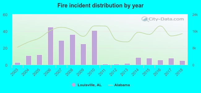 According to the data from the years 2003 - 2018 the average number of fires per year is 15. The highest number of reported fires - 45 took place in 2006, and the least - 1 in 2011. The data has a rising trend.
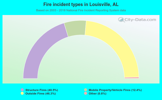 When looking into fire subcategories, the most reports belonged to: Outside Fires (46.3%), and Structure Fires (40.5%).
| Most common first names in Louisville, AL among deceased individuals | ||
| Name | Count | Lived (average) |
|---|---|---|
| Mary | 29 | 78.9 years |
| James | 25 | 77.0 years |
| William | 18 | 73.5 years |
| John | 17 | 75.4 years |
| Charlie | 12 | 67.3 years |
| Annie | 12 | 77.7 years |
| Robert | 10 | 70.2 years |
| Mattie | 8 | 74.6 years |
| Henry | 8 | 75.7 years |
| George | 7 | 79.5 years |
| Most common last names in Louisville, AL among deceased individuals | ||
| Last name | Count | Lived (average) |
|---|---|---|
| Helms | 18 | 73.5 years |
| Green | 16 | 79.3 years |
| Baker | 14 | 78.3 years |
| Dykes | 12 | 76.1 years |
| Baxter | 12 | 80.6 years |
| Beaty | 12 | 80.5 years |
| Price | 12 | 73.1 years |
| Boykin | 11 | 80.9 years |
| Campbell | 10 | 81.5 years |
| Clark | 9 | 76.0 years |
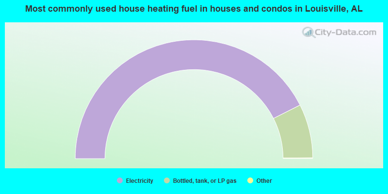
- 85.3%Electricity
- 14.7%Bottled, tank, or LP gas

- 86.8%Electricity
- 13.2%Bottled, tank, or LP gas
Louisville compared to Alabama state average:
- Median house value significantly below state average.
- Unemployed percentage significantly below state average.
- Black race population percentage above state average.
- Hispanic race population percentage below state average.
- Foreign-born population percentage significantly below state average.
- Length of stay since moving in significantly below state average.
- Percentage of population with a bachelor's degree or higher below state average.