Lyman, New Hampshire
Submit your own pictures of this town and show them to the world
- OSM Map
- Google Map
- MSN Map
Population change since 2000: +9.4%
 |
| Males: 269 | |
| Females: 264 |
| Median resident age: | 51.1 years |
| New Hampshire median age: | 43.9 years |
Zip codes: 03585.
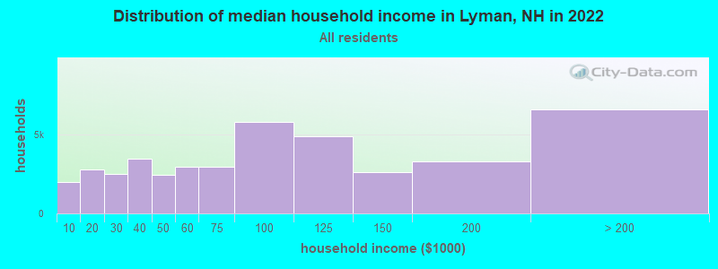
| Lyman: | $91,127 |
| NH: | $89,992 |
Estimated per capita income in 2022: $50,783 (it was $22,332 in 2000)
Lyman town income, earnings, and wages data
Estimated median house or condo value in 2022: $316,746 (it was $99,100 in 2000)
| Lyman: | $316,746 |
| NH: | $384,700 |
Mean prices in 2022: all housing units: $486,096; detached houses: $533,852; townhouses or other attached units: $375,744; in 2-unit structures: $230,260; in 3-to-4-unit structures: $242,363; in 5-or-more-unit structures: $588,257; mobile homes: $127,035
Detailed information about poverty and poor residents in Lyman, NH
Compare current foreclosures near Lyman, NH:
| Photo | Address | Area | Beds / Baths | Price | Details |
|---|---|---|---|---|---|

|
#1
Scott Hwy
Groton, VT 05046
|
- sq. feet
|
2 baths 3 beds |
$156,000
|
show details |

|
#2
Saint Johnsbury Rd
Littleton, NH 03561
|
1,672 sq. feet
|
1 baths 3 beds |
show details | |

|
#3
Mountain View Dr
Monroe, NH 03771
|
- sq. feet
|
- baths - beds |
show details | |

|
#4
Railroad St Ste 2
Saint Johnsbury, VT 05819
|
- sq. feet
|
- baths - beds |
show details | |

|
#5
Depot St
Haverhill, NH 03765
|
- sq. feet
|
- baths - beds |
show details | |

|
#6
Bishop Rd
Lisbon, NH 03585
|
- sq. feet
|
- baths - beds |
show details | |

|
#7
Maciver Rd
Littleton, NH 03561
|
- sq. feet
|
- baths - beds |
show details | |

|
#8
Washington St
Littleton, NH 03561
|
- sq. feet
|
- baths - beds |
show details | |

|
#9
Adams Dr
Woodsville, NH 03785
|
- sq. feet
|
- baths - beds |
show details | |

|
Check over 1 million property listings on Foreclosure.com!
|
browse all offers | |||

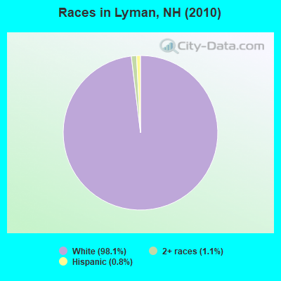
- 52398.1%White alone
- 61.1%Two or more races
- 40.8%Hispanic
Races in Lyman detailed stats: ancestries, foreign born residents, place of birth
According to our research of New Hampshire and other state lists, there was 1 registered sex offender living in Lyman, New Hampshire as of May 02, 2024.
The ratio of all residents to sex offenders in Lyman is 533 to 1.
The ratio of registered sex offenders to all residents in this city is near the state average.
 Recent articles from our blog. Our writers, many of them Ph.D. graduates or candidates, create easy-to-read articles on a wide variety of topics.
Ancestries: English (18.9%), Irish (15.8%), French (13.8%), French Canadian (7.6%), German (7.2%), United States (7.2%).
Current Local Time: EST time zone
Incorporated in 1761
Land area: 28.5 square miles.
Population density: 19 people per square mile (very low).
11 residents are foreign born (1.4% Europe, 0.4% Latin America, 0.4% North America).
| This town: | 2.3% |
| New Hampshire: | 4.4% |
| Lyman town: | 2.3% ($2,302) |
| New Hampshire: | 2.3% ($2,946) |
Nearest city with pop. 50,000+: Manchester, NH  (92.2 miles , pop. 107,006).
Nearest city with pop. 200,000+: Boston, MA (141.5 miles , pop. 589,141).
Nearest city with pop. 1,000,000+: Bronx, NY (257.0 miles , pop. 1,332,650).
Nearest cities:
), ), ), Latitude: 44.27 N, Longitude: 71.93 W
Area code commonly used in this area: 603
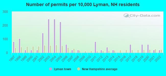
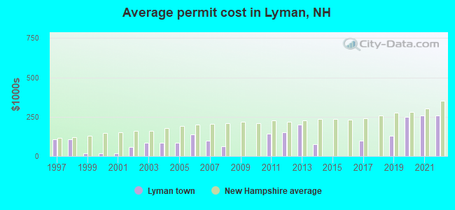
Single-family new house construction building permits:
- 2022: 1 building, cost: $259,200
- 2021: 1 building, cost: $259,200
- 2020: 3 buildings, average cost: $248,200
- 2019: 3 buildings, average cost: $130,000
- 2017: 3 buildings, average cost: $100,000
- 2014: 1 building, cost: $75,000
- 2013: 2 buildings, average cost: $200,000
- 2012: 1 building, cost: $150,000
- 2011: 4 buildings, average cost: $143,400
- 2008: 1 building, cost: $63,000
- 2007: 1 building, cost: $100,000
- 2006: 3 buildings, average cost: $140,000
- 2005: 11 buildings, average cost: $82,900
- 2004: 12 buildings, average cost: $82,900
- 2003: 12 buildings, average cost: $82,900
- 2002: 7 buildings, average cost: $59,300
- 2001: 1 building, cost: $20,000
- 2000: 1 building, cost: $20,000
- 1999: 1 building, cost: $20,000
- 1998: 5 buildings, average cost: $105,000
- 1997: 4 buildings, average cost: $105,000
| Here: | 1.5% |
| New Hampshire: | 2.5% |

- Metal & metal products (17.0%)
- Construction (7.9%)
- Public administration (7.6%)
- Health care (6.5%)
- Electronic shopping & mail-order houses (5.4%)
- Electrical equipment, appliances, components (5.4%)
- Educational services (5.1%)
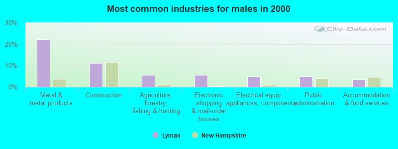
- Metal & metal products (22.2%)
- Construction (11.1%)
- Agriculture, forestry, fishing & hunting (5.6%)
- Electronic shopping & mail-order houses (5.6%)
- Electrical equipment, appliances, components (4.9%)
- Public administration (4.9%)
- Accommodation & food services (3.5%)
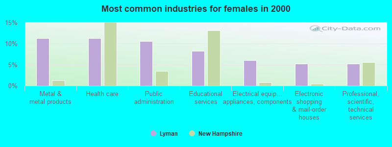
- Metal & metal products (11.3%)
- Health care (11.3%)
- Public administration (10.5%)
- Educational services (8.3%)
- Electrical equipment, appliances, components (6.0%)
- Electronic shopping & mail-order houses (5.3%)
- Professional, scientific, technical services (5.3%)
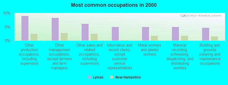
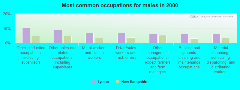
- Other production occupations, including supervisors (9.0%)
- Other management occupations, except farmers and farm managers (8.3%)
- Other sales and related occupations, including supervisors (6.1%)
- Information and record clerks, except customer service representatives (5.1%)
- Metal workers and plastic workers (5.1%)
- Material recording, scheduling, dispatching, and distributing workers (5.1%)
- Building and grounds cleaning and maintenance occupations (4.7%)
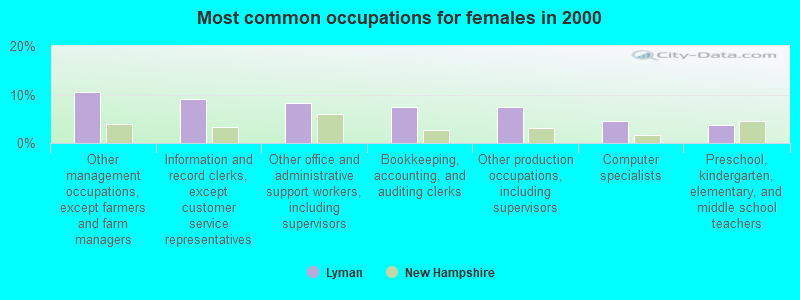
- Other production occupations, including supervisors (10.4%)
- Other sales and related occupations, including supervisors (9.0%)
- Metal workers and plastic workers (6.9%)
- Driver/sales workers and truck drivers (6.9%)
- Other management occupations, except farmers and farm managers (6.2%)
- Building and grounds cleaning and maintenance occupations (6.2%)
- Material recording, scheduling, dispatching, and distributing workers (6.2%)
- Other management occupations, except farmers and farm managers (10.5%)
- Information and record clerks, except customer service representatives (9.0%)
- Other office and administrative support workers, including supervisors (8.3%)
- Bookkeeping, accounting, and auditing clerks (7.5%)
- Other production occupations, including supervisors (7.5%)
- Computer specialists (4.5%)
- Preschool, kindergarten, elementary, and middle school teachers (3.8%)
Average climate in Lyman, New Hampshire
Based on data reported by over 4,000 weather stations


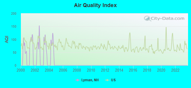
Earthquake activity:
Lyman-area historical earthquake activity is significantly above New Hampshire state average. It is 72% smaller than the overall U.S. average.On 4/20/2002 at 10:50:47, a magnitude 5.3 (5.3 ML, Depth: 3.0 mi, Class: Moderate, Intensity: VI - VII) earthquake occurred 89.0 miles away from Lyman center
On 4/20/2002 at 10:50:47, a magnitude 5.2 (5.2 MB, 4.2 MS, 5.2 MW, 5.0 MW) earthquake occurred 89.7 miles away from Lyman center
On 10/7/1983 at 10:18:46, a magnitude 5.3 (5.1 MB, 5.3 LG, 5.1 ML) earthquake occurred 122.0 miles away from Lyman center
On 1/19/1982 at 00:14:42, a magnitude 4.7 (4.5 MB, 4.7 MD, 4.5 LG, Class: Light, Intensity: IV - V) earthquake occurred 56.0 miles away from Lyman center
On 10/16/2012 at 23:12:25, a magnitude 4.7 (4.7 ML, Depth: 10.0 mi) earthquake occurred 78.7 miles away from the city center
On 6/16/1995 at 12:13:11, a magnitude 3.8 (3.8 LG, Depth: 3.1 mi, Class: Light, Intensity: II - III) earthquake occurred 1.0 miles away from Lyman center
Magnitude types: regional Lg-wave magnitude (LG), body-wave magnitude (MB), duration magnitude (MD), local magnitude (ML), surface-wave magnitude (MS), moment magnitude (MW)
Natural disasters:
The number of natural disasters in Grafton County (32) is a lot greater than the US average (15).Major Disasters (Presidential) Declared: 20
Emergencies Declared: 9
Causes of natural disasters: Floods: 16, Storms: 16, Hurricanes: 3, Snows: 3, Winter Storms: 3, Tropical Storms: 2, Blizzard: 1, Heavy Rain: 1, Ice Storm: 1, Landslide: 1, Snowfall: 1, Snowstorm: 1, Wind: 1, Other: 1 (Note: some incidents may be assigned to more than one category).
Hospitals and medical centers near Lyman:
- NORTH COUNTRY HOME HEALTH AND HOSPICE AGENCY (Home Health Center, about 8 miles away; LITTLETON, NH)
- LAFAYETTE CENTER, GENESIS HEALTHCARE (Nursing Home, about 10 miles away; FRANCONIA, NH)
- COTTAGE HOSPITAL Critical Access Hospitals (about 12 miles away; WOODSVILLE, NH)
- NORTHEASTERN VERMONT REGIONAL HOSPITAL Critical Access Hospitals (about 13 miles away; SAINT JOHNSBURY, VT)
- ST JOHNSBURY HEALTH AND REHAB (Nursing Home, about 13 miles away; SAINT JOHNSBURY, VT)
- FMC OF ST. JOHNSBURY DIALYSIS (Dialysis Facility, about 13 miles away; SAINT JOHNSBURY, VT)
- CALEDONIA HOME HEALTH CARE (Home Health Center, about 13 miles away; SAINT JOHNSBURY, VT)
Colleges/universities with over 2000 students nearest to Lyman:
- Norwich University (about 38 miles; Northfield, VT; Full-time enrollment: 4,221)
- Plymouth State University (about 38 miles; Plymouth, NH; FT enrollment: 4,838)
- Dartmouth College (about 44 miles; Hanover, NH; FT enrollment: 6,030)
- Saint Michael's College (about 63 miles; Colchester, VT; FT enrollment: 2,336)
- Community College of Vermont (about 64 miles; Winooski, VT; FT enrollment: 3,394)
- University of Vermont (about 65 miles; Burlington, VT; FT enrollment: 11,566)
- Champlain College (about 65 miles; Burlington, VT; FT enrollment: 2,623)
Points of interest:
Notable location: Ogontz White Mountain Camp (A). Display/hide its location on the map
Cemeteries: Pond Cemetery (1), Moulton Hill Cemetery (2). Display/hide their locations on the map
Lakes and reservoirs: Flag Pond (A), Lower Mountain Pond (B), Ogontz Lake (C), Round Pond (D), Dodge Pond (E). Display/hide their locations on the map
Streams, rivers, and creeks: Moulton Hill Brook (A), Patten Brook (B), Teter Meadow Brook (C). Display/hide their locations on the map
Birthplace of: Amasa Lyman - Mormon missionary.
| This town: | 2.2 people |
| New Hampshire: | 2.5 people |
| This town: | 68.8% |
| Whole state: | 66.3% |
| This town: | 7.1% |
| Whole state: | 8.3% |
No gay or lesbian households reported
| This town: | 6.5% |
| Whole state: | 6.5% |
| This town: | 2.5% |
| Whole state: | 2.8% |
For population 15 years and over in Lyman:

- Never married: 18.5%
- Now married: 65.3%
- Separated: 0.0%
- Widowed: 7.9%
- Divorced: 8.4%
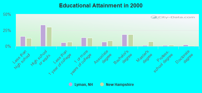
For population 25 years and over in Lyman:
- High school or higher: 84.5%
- Bachelor's degree or higher: 24.3%
- Graduate or professional degree: 5.8%
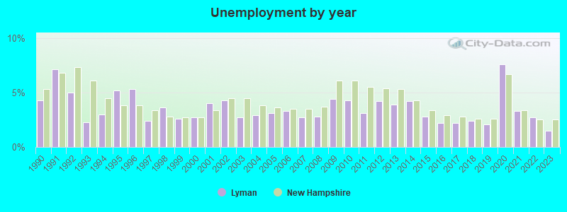
- Unemployed: 6.7%
- Mean travel time to work (commute): 29.1 minutes
| Here: | 11.2 |
| New Hampshire average: | 10.9 |


Graphs represent county-level data. Detailed 2008 Election Results
Religion statistics for Lyman, NH (based on Grafton County data)


| Religion | Adherents | Congregations |
|---|---|---|
| Catholic | 9,503 | 12 |
| Mainline Protestant | 7,832 | 57 |
| Evangelical Protestant | 1,494 | 29 |
| Other | 1,320 | 11 |
| None | 68,969 | - |
Food Environment Statistics:
| This county: | 3.87 / 10,000 pop. |
| State: | 2.14 / 10,000 pop. |
| Here: | 0.23 / 10,000 pop. |
| New Hampshire: | 0.15 / 10,000 pop. |
| This county: | 1.29 / 10,000 pop. |
| New Hampshire: | 1.78 / 10,000 pop. |
| This county: | 6.45 / 10,000 pop. |
| New Hampshire: | 4.02 / 10,000 pop. |
| Grafton County: | 14.41 / 10,000 pop. |
| New Hampshire: | 9.70 / 10,000 pop. |
| This county: | 7.2% |
| New Hampshire: | 7.6% |
| Grafton County: | 22.9% |
| New Hampshire: | 24.4% |
| Here: | 15.9% |
| New Hampshire: | 15.9% |
Strongest AM radio stations in Lyman:
- WTWN (1100 AM; daytime; 5 kW; WELLS RIVER, VT; Owner: PUFFER BROADCASTING, INC.)
- WLTN (1400 AM; 1 kW; LITTLETON, NH; Owner: PROFILE BROADCASTING COMPANY, INC.)
- WSTJ (1340 AM; 1 kW; ST. JOHNSBURY, VT; Owner: VERMONT BROADCAST ASSOCIATES, INC.)
- WCHP (760 AM; 35 kW; CHAMPLAIN, NY; Owner: CHAMPLAIN RADIO, INC.)
- WDEV (550 AM; 5 kW; WATERBURY, VT; Owner: RADIO VERMONT, INC.)
- WRKO (680 AM; 50 kW; BOSTON, MA; Owner: ENTERCOM BOSTON LICENSE, LLC)
- WNNZ (640 AM; 50 kW; WESTFIELD, MA; Owner: CLEAR CHANNEL BROADCASTING LICENSES, INC.)
- WCRN (830 AM; 50 kW; WORCESTER, MA; Owner: CARTER BROADCASTING CORPORATION)
- WPNH (1300 AM; 5 kW; PLYMOUTH, NH; Owner: NORTHEAST COMMUNICATIONS CORPORATION)
- WEEI (850 AM; 50 kW; BOSTON, MA; Owner: ENTERCOM BOSTON LICENSE, LLC)
- WGY (810 AM; 50 kW; SCHENECTADY, NY; Owner: CLEAR CHANNEL BROADCASTING LICENSES, INC.)
- WTME (780 AM; 10 kW; RUMFORD, ME; Owner: MOUNTAIN VALLEY BROADCASTING, INC.)
- WICY (1490 AM; 50 kW; MALONE, NY; Owner: CARTIER COMMUNICATIONS INC.)
Strongest FM radio stations in Lyman:
- WLTN-FM (96.7 FM; LISBON, NH; Owner: PROFILE BROADCASTING CO., INC.)
- WMTK (106.3 FM; LITTLETON, NH; Owner: VERMONT BROADCAST ASSOCIATES, INC.)
- WGMT (97.7 FM; LYNDON, VT; Owner: VERMONT BROADCAST ASSOCIATES, INC.)
- WPKQ (103.7 FM; NORTH CONWAY, NH; Owner: CITADEL BROADCASTING COMPANY)
- WHOM (94.9 FM; MT. WASHINGTON, NH; Owner: CITADEL BROADCASTING COMPANY)
- WCKJ (90.5 FM; ST. JOHNSBURY, VT; Owner: CHRISTIAN MINISTRIES, INC.)
- WKXH (105.5 FM; ST. JOHNSBURY, VT; Owner: VERMONT BROADCAST ASSOCIATES, INC.)
- WDOT (95.7 FM; DANVILLE, VT; Owner: MONTPELIER BROADCASTING INC)
- WXXS (102.3 FM; LANCASTER, NH; Owner: BARRY P. LUNDERVILLE)
- WVFM (105.7 FM; CAMPTON, NH; Owner: DEVON BROADCASTING COMPANY, INC.)
- WCVT (101.7 FM; STOWE, VT; Owner: RADIO VERMONT CLASSICS, L.L.C.)
- WLKC (103.3 FM; WATERBURY, VT; Owner: RADIO BROADCASTING SERVICES, INC.)
- WVPS (107.9 FM; BURLINGTON, VT; Owner: VERMONT PUBLIC RADIO)
- WEZF (92.9 FM; BURLINGTON, VT; Owner: CAPSTAR TX LIMITED PARTNERSHIP)
- WNCS (104.7 FM; MONTPELIER, VT; Owner: MONTPELIER BROADCASTING, INC.)
- WYKR-FM (101.3 FM; HAVERHILL, NH; Owner: PUFFER BROADCASTING, INC.)
- WSCY (106.9 FM; MOULTONBOROUGH, NH; Owner: NORTHEAST COMMUNICATIONS CORPORATION)
- WDEV-FM (96.1 FM; WARREN, VT; Owner: RADIO VERMONT, INC.)
- WEBK (105.3 FM; KILLINGTON, VT; Owner: 6 JOHNSON ROAD LICENSES, INC.)
- WPNH-FM (100.1 FM; PLYMOUTH, NH; Owner: NORTHEAST COMMUNICATIONS CORPORATION)
TV broadcast stations around Lyman:
- WLED-TV (Channel 49; LITTLETON, NH; Owner: UNIVERSITY OF NEW HAMPSHIRE)
- National Bridge Inventory (NBI) Statistics
- 3Number of bridges
- 7ft / 2.2mTotal length
- $9,426,000Total costs
- 289Total average daily traffic
- 8Total average daily truck traffic
- 425Total future (year 2042) average daily traffic
FCC Registered Amateur Radio Licenses:
1- Call Sign: N1JJN, Previous Call Sign: KA1QIU, Licensee ID: L00656602, Grant Date: 04/10/2012, Expiration Date: 06/18/2022, Certifier: Kenelm J Parker, Registrant: Kenelm J Parker, 319 Hurd Hill Road, Lyman, NH 03585
FAA Registered Aircraft:
1- Aircraft: CESSNA 172 (Category: Land, Seats: 4, Weight: Up to 12,499 Pounds, Speed: 105 mph), Engine: CONT MOTOR 0-300 SER (145 HP) (Reciprocating)
N-Number: 8828B, N8828B, N-8828B, Serial Number: 36528, Year manufactured: 1957, Airworthiness Date: 12/20/1957, Certificate Issue Date: 01/26/2004
Registrant (Individual): Abigail M Thomas, 473 Skinny Ridge Rd, Lyman, NH 03585
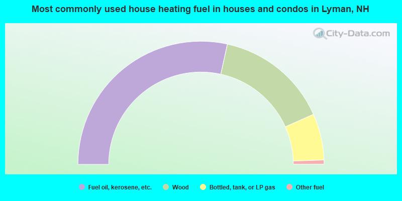
- 56.9%Fuel oil, kerosene, etc.
- 29.8%Wood
- 12.2%Bottled, tank, or LP gas
- 1.1%Other fuel
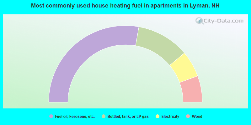
- 55.6%Fuel oil, kerosene, etc.
- 22.2%Bottled, tank, or LP gas
- 11.1%Electricity
- 11.1%Wood
Lyman compared to New Hampshire state average:
- Unemployed percentage below state average.
- Black race population percentage significantly below state average.
- Hispanic race population percentage significantly below state average.
- Median age above state average.
- Foreign-born population percentage significantly below state average.
- Renting percentage significantly below state average.
- Length of stay since moving in significantly above state average.
- Number of rooms per house significantly below state average.
- House age significantly below state average.
- Number of college students below state average.

|
Total of 1 patent application in 2008-2024.