Sugar Hill, New Hampshire
Submit your own pictures of this town and show them to the world
- OSM Map
- General Map
- Google Map
- MSN Map
Population change since 2000: 0.0%
 |
| Males: 281 | |
| Females: 282 |
| Median resident age: | 52.4 years |
| New Hampshire median age: | 43.9 years |
Zip codes: 03585.
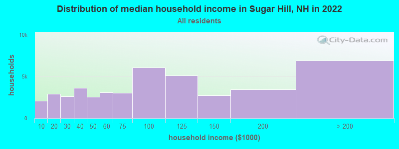
| Sugar Hill: | $96,234 |
| NH: | $89,992 |
Estimated per capita income in 2022: $67,635 (it was $29,743 in 2000)
Sugar Hill town income, earnings, and wages data
Estimated median house or condo value in 2022: $549,431 (it was $171,900 in 2000)
| Sugar Hill: | $549,431 |
| NH: | $384,700 |
Mean prices in 2022: all housing units: $486,096; detached houses: $533,852; townhouses or other attached units: $375,744; in 2-unit structures: $230,260; in 3-to-4-unit structures: $242,363; in 5-or-more-unit structures: $588,257; mobile homes: $127,035
Detailed information about poverty and poor residents in Sugar Hill, NH


- 53595.0%White alone
- 112.0%Asian alone
- 101.8%Hispanic
- 71.2%Two or more races
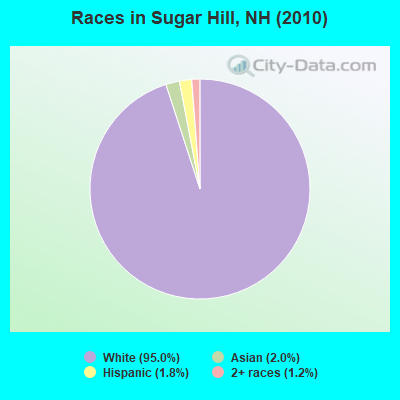
Races in Sugar Hill detailed stats: ancestries, foreign born residents, place of birth
According to our research of New Hampshire and other state lists, there was 1 registered sex offender living in Sugar Hill, New Hampshire as of April 28, 2024.
The ratio of all residents to sex offenders in Sugar Hill is 563 to 1.
The ratio of registered sex offenders to all residents in this city is near the state average.
Type |
2009 |
2011 |
2012 |
2013 |
2014 |
2015 |
2016 |
2017 |
2018 |
2019 |
2020 |
2022 |
|---|---|---|---|---|---|---|---|---|---|---|---|---|
| Murders (per 100,000) | 0 (0.0) | 0 (0.0) | 0 (0.0) | 0 (0.0) | 0 (0.0) | 0 (0.0) | 0 (0.0) | 0 (0.0) | 0 (0.0) | 0 (0.0) | 0 (0.0) | 0 (0.0) |
| Rapes (per 100,000) | 0 (0.0) | 0 (0.0) | 0 (0.0) | 1 (177.3) | 0 (0.0) | 0 (0.0) | 0 (0.0) | 0 (0.0) | 0 (0.0) | 0 (0.0) | 0 (0.0) | 0 (0.0) |
| Robberies (per 100,000) | 0 (0.0) | 0 (0.0) | 0 (0.0) | 0 (0.0) | 0 (0.0) | 0 (0.0) | 0 (0.0) | 0 (0.0) | 0 (0.0) | 0 (0.0) | 0 (0.0) | 0 (0.0) |
| Assaults (per 100,000) | 0 (0.0) | 0 (0.0) | 0 (0.0) | 0 (0.0) | 0 (0.0) | 0 (0.0) | 0 (0.0) | 0 (0.0) | 0 (0.0) | 0 (0.0) | 0 (0.0) | 0 (0.0) |
| Burglaries (per 100,000) | 1 (161.8) | 1 (177.3) | 4 (710.5) | 2 (354.6) | 2 (349.7) | 1 (174.2) | 6 (1,058) | 0 (0.0) | 0 (0.0) | 0 (0.0) | 0 (0.0) | 0 (0.0) |
| Thefts (per 100,000) | 2 (323.6) | 6 (1,064) | 2 (355.2) | 1 (177.3) | 7 (1,224) | 5 (871.1) | 4 (705.5) | 0 (0.0) | 0 (0.0) | 0 (0.0) | 4 (690.8) | 1 (151.1) |
| Auto thefts (per 100,000) | 0 (0.0) | 0 (0.0) | 0 (0.0) | 0 (0.0) | 1 (174.8) | 0 (0.0) | 0 (0.0) | 0 (0.0) | 0 (0.0) | 1 (172.7) | 0 (0.0) | 0 (0.0) |
| Arson (per 100,000) | 0 (0.0) | 0 (0.0) | 0 (0.0) | 0 (0.0) | 0 (0.0) | 0 (0.0) | 0 (0.0) | 0 (0.0) | 0 (0.0) | 0 (0.0) | 0 (0.0) | 0 (0.0) |
| City-Data.com crime index | 24.3 | 55.0 | 63.9 | 173.8 | 87.4 | 47.0 | 102.3 | 0.0 | 0.0 | 13.8 | 27.6 | 6.0 |
The City-Data.com crime index weighs serious crimes and violent crimes more heavily. Higher means more crime, U.S. average is 246.1. It adjusts for the number of visitors and daily workers commuting into cities.
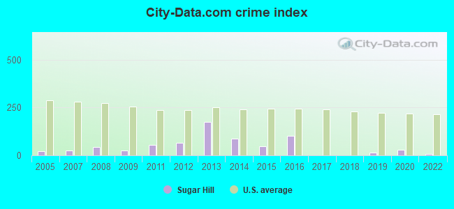
Crime rate in Sugar Hill detailed stats: murders, rapes, robberies, assaults, burglaries, thefts, arson
Full-time law enforcement employees in 2021, including police officers: 2 (2 officers - 1 male; 1 female).
| Officers per 1,000 residents here: | 3.41 |
| New Hampshire average: | 2.14 |
 Recent articles from our blog. Our writers, many of them Ph.D. graduates or candidates, create easy-to-read articles on a wide variety of topics.

 | Questions about Littleton/Sugar Hill area (1 reply) |
| Your Advice on moving to the Conway Area (18 replies) |
| Car camping near the lupines? (0 replies) |
| Thinking of moving to NH....no clue where (11 replies) |
| where to start a family in NH? (37 replies) |
| New Hampshire is a Fraud (18 replies) |
Latest news from Sugar Hill, NH collected exclusively by city-data.com from local newspapers, TV, and radio stations
Ancestries: English (32.0%), Irish (21.0%), French (14.2%), German (12.8%), Scottish (5.9%), Italian (4.8%).
Current Local Time: EST time zone
Incorporated in 1962
Elevation: 1328 feet
Land area: 17.1 square miles.
Population density: 33 people per square mile (very low).
19 residents are foreign born (2.1% North America, 0.9% Europe, 0.4% Asia).
| This town: | 3.4% |
| New Hampshire: | 4.4% |
| Sugar Hill town: | 1.5% ($2,646) |
| New Hampshire: | 2.3% ($2,946) |
Nearest city with pop. 50,000+: Portland, ME  (84.6 miles , pop. 64,249).
Nearest city with pop. 200,000+: Boston, MA (136.0 miles , pop. 589,141).
Nearest city with pop. 1,000,000+: Bronx, NY (256.6 miles , pop. 1,332,650).
Nearest cities:
), ), Latitude: 44.22 N, Longitude: 71.78 W
Area code commonly used in this area: 603

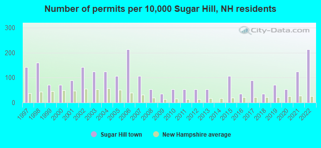
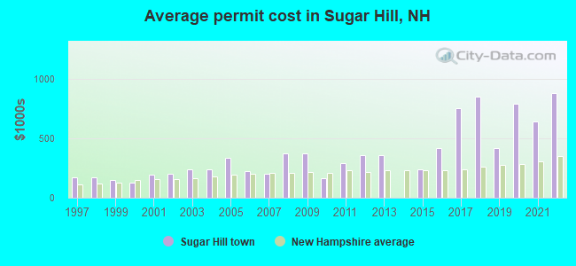
Single-family new house construction building permits:
- 2022: 12 buildings, average cost: $879,800
- 2021: 7 buildings, average cost: $642,900
- 2020: 3 buildings, average cost: $788,300
- 2019: 4 buildings, average cost: $413,800
- 2018: 2 buildings, average cost: $850,000
- 2017: 5 buildings, average cost: $751,000
- 2016: 2 buildings, average cost: $417,500
- 2015: 6 buildings, average cost: $241,600
- 2013: 3 buildings, average cost: $358,300
- 2012: 3 buildings, average cost: $358,300
- 2011: 3 buildings, average cost: $286,700
- 2010: 3 buildings, average cost: $163,300
- 2009: 2 buildings, average cost: $370,000
- 2008: 3 buildings, average cost: $370,000
- 2007: 6 buildings, average cost: $201,300
- 2006: 12 buildings, average cost: $221,300
- 2005: 6 buildings, average cost: $332,000
- 2004: 7 buildings, average cost: $239,300
- 2003: 7 buildings, average cost: $239,300
- 2002: 8 buildings, average cost: $198,100
- 2001: 5 buildings, average cost: $191,000
- 2000: 4 buildings, average cost: $127,500
- 1999: 4 buildings, average cost: $148,800
- 1998: 9 buildings, average cost: $171,900
- 1997: 8 buildings, average cost: $171,900
| Here: | 2.0% |
| New Hampshire: | 2.5% |
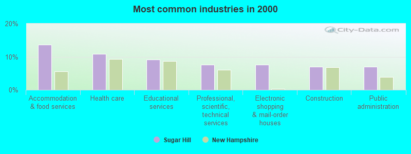
- Accommodation & food services (13.7%)
- Health care (10.8%)
- Educational services (9.2%)
- Professional, scientific, technical services (7.6%)
- Electronic shopping & mail-order houses (7.6%)
- Construction (7.0%)
- Public administration (7.0%)
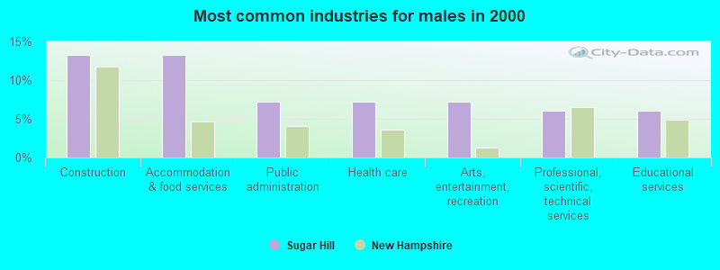
- Construction (13.3%)
- Accommodation & food services (13.3%)
- Public administration (7.2%)
- Health care (7.2%)
- Arts, entertainment, recreation (7.2%)
- Professional, scientific, technical services (6.0%)
- Educational services (6.0%)
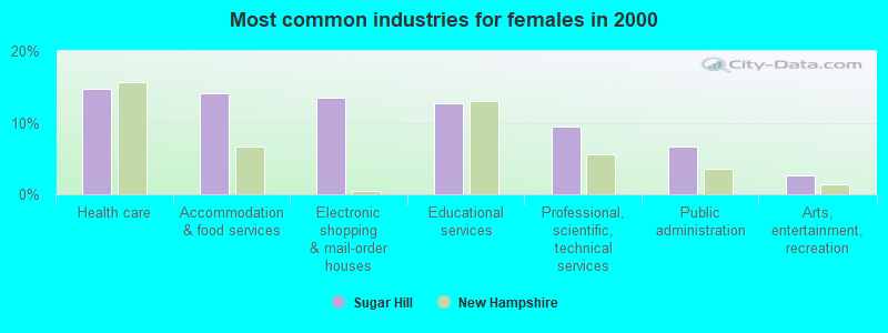
- Health care (14.8%)
- Accommodation & food services (14.1%)
- Electronic shopping & mail-order houses (13.4%)
- Educational services (12.8%)
- Professional, scientific, technical services (9.4%)
- Public administration (6.7%)
- Arts, entertainment, recreation (2.7%)
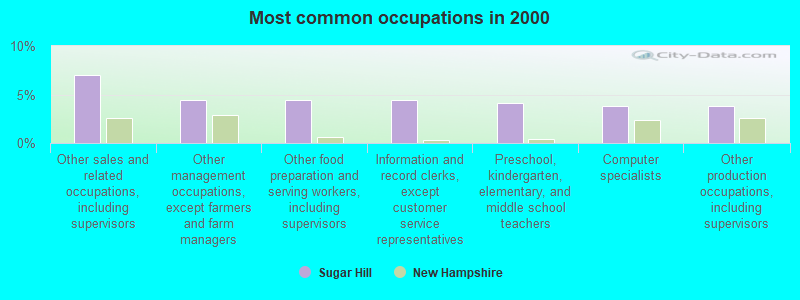
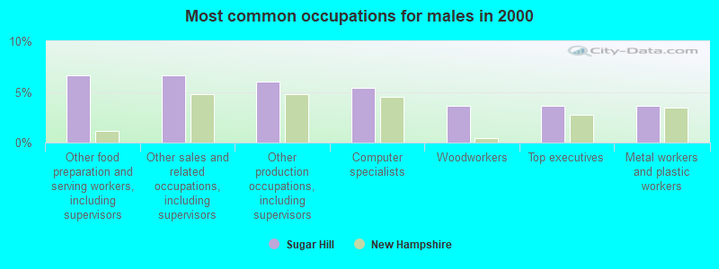
- Other sales and related occupations, including supervisors (7.0%)
- Other management occupations, except farmers and farm managers (4.4%)
- Other food preparation and serving workers, including supervisors (4.4%)
- Information and record clerks, except customer service representatives (4.4%)
- Preschool, kindergarten, elementary, and middle school teachers (4.1%)
- Computer specialists (3.8%)
- Other production occupations, including supervisors (3.8%)
- Other food preparation and serving workers, including supervisors (6.6%)
- Other sales and related occupations, including supervisors (6.6%)
- Other production occupations, including supervisors (6.0%)
- Computer specialists (5.4%)
- Woodworkers (3.6%)
- Top executives (3.6%)
- Metal workers and plastic workers (3.6%)
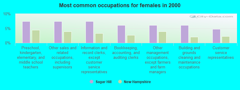
- Preschool, kindergarten, elementary, and middle school teachers (7.4%)
- Other sales and related occupations, including supervisors (7.4%)
- Information and record clerks, except customer service representatives (7.4%)
- Bookkeeping, accounting, and auditing clerks (6.0%)
- Other management occupations, except farmers and farm managers (6.0%)
- Building and grounds cleaning and maintenance occupations (6.0%)
- Customer service representatives (4.7%)
Average climate in Sugar Hill, New Hampshire
Based on data reported by over 4,000 weather stations


(lower is better)
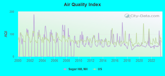
Air Quality Index (AQI) level in 2022 was 44.6. This is significantly better than average.
| City: | 44.6 |
| U.S.: | 72.6 |
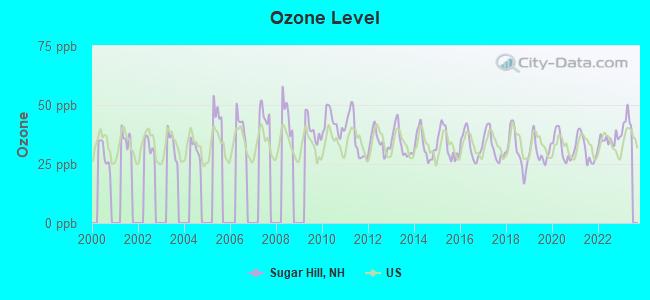
Ozone [ppb] level in 2022 was 35.3. This is about average. Closest monitor was 6.2 miles away from the city center.
| City: | 35.3 |
| U.S.: | 33.3 |
Earthquake activity:
Sugar Hill-area historical earthquake activity is significantly above New Hampshire state average. It is 72% smaller than the overall U.S. average.On 4/20/2002 at 10:50:47, a magnitude 5.3 (5.3 ML, Depth: 3.0 mi, Class: Moderate, Intensity: VI - VII) earthquake occurred 96.8 miles away from the city center
On 4/20/2002 at 10:50:47, a magnitude 5.2 (5.2 MB, 4.2 MS, 5.2 MW, 5.0 MW) earthquake occurred 97.5 miles away from Sugar Hill center
On 10/7/1983 at 10:18:46, a magnitude 5.3 (5.1 MB, 5.3 LG, 5.1 ML) earthquake occurred 128.5 miles away from Sugar Hill center
On 1/19/1982 at 00:14:42, a magnitude 4.7 (4.5 MB, 4.7 MD, 4.5 LG, Class: Light, Intensity: IV - V) earthquake occurred 50.8 miles away from Sugar Hill center
On 10/16/2012 at 23:12:25, a magnitude 4.7 (4.7 ML, Depth: 10.0 mi) earthquake occurred 70.8 miles away from the city center
On 6/16/1995 at 12:13:11, a magnitude 3.8 (3.8 LG, Depth: 3.1 mi, Class: Light, Intensity: II - III) earthquake occurred 7.9 miles away from Sugar Hill center
Magnitude types: regional Lg-wave magnitude (LG), body-wave magnitude (MB), duration magnitude (MD), local magnitude (ML), surface-wave magnitude (MS), moment magnitude (MW)
Natural disasters:
The number of natural disasters in Grafton County (32) is a lot greater than the US average (15).Major Disasters (Presidential) Declared: 20
Emergencies Declared: 9
Causes of natural disasters: Floods: 16, Storms: 16, Hurricanes: 3, Snows: 3, Winter Storms: 3, Tropical Storms: 2, Blizzard: 1, Heavy Rain: 1, Ice Storm: 1, Landslide: 1, Snowfall: 1, Snowstorm: 1, Wind: 1, Other: 1 (Note: some incidents may be assigned to more than one category).

Hospitals and medical centers near Sugar Hill:
- LAFAYETTE CENTER, GENESIS HEALTHCARE (Nursing Home, about 2 miles away; FRANCONIA, NH)
- NORTH COUNTRY HOME HEALTH AND HOSPICE AGENCY (Home Health Center, about 5 miles away; LITTLETON, NH)
- COTTAGE HOSPITAL Critical Access Hospitals (about 11 miles away; WOODSVILLE, NH)
- MORRISON NURSING HOME (Nursing Home, about 14 miles away; WHITEFIELD, NH)
- GRAFTON COUNTY NURSING HOME (Nursing Home, about 16 miles away; NORTH HAVERHILL, NH)
Colleges/universities with over 2000 students nearest to Sugar Hill:
- Plymouth State University (about 33 miles; Plymouth, NH; Full-time enrollment: 4,838)
- Dartmouth College (about 44 miles; Hanover, NH; FT enrollment: 6,030)
- Norwich University (about 44 miles; Northfield, VT; FT enrollment: 4,221)
- Saint Joseph's College of Maine (about 71 miles; Standish, ME; FT enrollment: 2,010)
- NHTI-Concord's Community College (about 71 miles; Concord, NH; FT enrollment: 2,865)
- Middlebury College (about 71 miles; Middlebury, VT; FT enrollment: 3,077)
- Saint Michael's College (about 71 miles; Colchester, VT; FT enrollment: 2,336)
Points of interest:
Notable locations in Sugar Hill: Sunset Hill House Ski Touring Center (A), Sugar Hill Fire Department (B). Display/hide their locations on the map
Churches in Sugar Hill include: Saint Matthews Church (A), Community Church (B). Display/hide their locations on the map
Cemetery: Sunny Side Cemetery (1). Display/hide its location on the map
Reservoirs: Streeter Pond (A), Coffin Pond (B). Display/hide their locations on the map
Streams, rivers, and creeks: Indian Brook (A). Display/hide its location on the map
Hotel: North Country Cottages (11 Gilmanton Hill Road) (1). Display/hide its approximate location on the map
Drinking water stations with addresses in Sugar Hill and their reported violations in the past:
SUGAR HILL INN (Address: 116 RTE 117 , Population served: 25, Groundwater):Past health violations:Past monitoring violations:
- MCL, Monthly (TCR) - Between OCT-2010 and DEC-2010, Contaminant: Coliform. Follow-up actions: St Public Notif requested (JAN-19-2011), St Violation/Reminder Notice (JAN-19-2011), St Public Notif received (MAR-10-2011), St Compliance achieved (JUN-20-2011)
- MCL, Monthly (TCR) - Between JUL-2008 and SEP-2008, Contaminant: Coliform. Follow-up actions: St Public Notif requested (AUG-15-2008), St Violation/Reminder Notice (AUG-15-2008), St Public Notif received (AUG-26-2008), St Compliance achieved (MAR-04-2009)
- 4 routine major monitoring violations
- One regular monitoring violation
Drinking water stations with addresses in Sugar Hill that have no violations reported:
- POLLYS PANCAKE PARLOR (Population served: 250, Primary Water Source Type: Groundwater)
| This town: | 2.2 people |
| New Hampshire: | 2.5 people |
| This town: | 66.9% |
| Whole state: | 66.3% |
| This town: | 5.1% |
| Whole state: | 8.3% |
Likely homosexual households (counted as self-reported same-sex unmarried-partner households)
- Lesbian couples: 0.8% of all households
- Gay men: 1.2% of all households
| This town: | 5.3% |
| Whole state: | 6.5% |
| This town: | 2.1% |
| Whole state: | 2.8% |
For population 15 years and over in Sugar Hill:
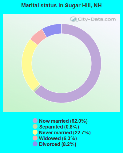
- Never married: 22.7%
- Now married: 62.0%
- Separated: 0.8%
- Widowed: 6.3%
- Divorced: 8.2%
For population 25 years and over in Sugar Hill:
- High school or higher: 95.8%
- Bachelor's degree or higher: 48.6%
- Graduate or professional degree: 21.2%
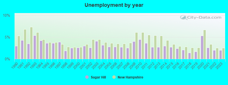
- Unemployed: 1.6%
- Mean travel time to work (commute): 19.3 minutes

| Here: | 10.6 |
| New Hampshire average: | 10.9 |


Graphs represent county-level data. Detailed 2008 Election Results
Religion statistics for Sugar Hill, NH (based on Grafton County data)


| Religion | Adherents | Congregations |
|---|---|---|
| Catholic | 9,503 | 12 |
| Mainline Protestant | 7,832 | 57 |
| Evangelical Protestant | 1,494 | 29 |
| Other | 1,320 | 11 |
| None | 68,969 | - |
Food Environment Statistics:
| Grafton County: | 3.87 / 10,000 pop. |
| New Hampshire: | 2.14 / 10,000 pop. |
| Grafton County: | 0.23 / 10,000 pop. |
| State: | 0.15 / 10,000 pop. |
| Grafton County: | 1.29 / 10,000 pop. |
| New Hampshire: | 1.78 / 10,000 pop. |
| Grafton County: | 6.45 / 10,000 pop. |
| New Hampshire: | 4.02 / 10,000 pop. |
| Grafton County: | 14.41 / 10,000 pop. |
| State: | 9.70 / 10,000 pop. |
| Grafton County: | 7.2% |
| New Hampshire: | 7.6% |
| This county: | 22.9% |
| New Hampshire: | 24.4% |
| This county: | 15.9% |
| State: | 15.9% |
Strongest AM radio stations in Sugar Hill:
- WTWN (1100 AM; daytime; 5 kW; WELLS RIVER, VT; Owner: PUFFER BROADCASTING, INC.)
- WLTN (1400 AM; 1 kW; LITTLETON, NH; Owner: PROFILE BROADCASTING COMPANY, INC.)
- WCHP (760 AM; 35 kW; CHAMPLAIN, NY; Owner: CHAMPLAIN RADIO, INC.)
- WRKO (680 AM; 50 kW; BOSTON, MA; Owner: ENTERCOM BOSTON LICENSE, LLC)
- WPNH (1300 AM; 5 kW; PLYMOUTH, NH; Owner: NORTHEAST COMMUNICATIONS CORPORATION)
- WDEV (550 AM; 5 kW; WATERBURY, VT; Owner: RADIO VERMONT, INC.)
- WNNZ (640 AM; 50 kW; WESTFIELD, MA; Owner: CLEAR CHANNEL BROADCASTING LICENSES, INC.)
- WCRN (830 AM; 50 kW; WORCESTER, MA; Owner: CARTER BROADCASTING CORPORATION)
- WEEI (850 AM; 50 kW; BOSTON, MA; Owner: ENTERCOM BOSTON LICENSE, LLC)
- WTME (780 AM; 10 kW; RUMFORD, ME; Owner: MOUNTAIN VALLEY BROADCASTING, INC.)
- WGY (810 AM; 50 kW; SCHENECTADY, NY; Owner: CLEAR CHANNEL BROADCASTING LICENSES, INC.)
- WSTJ (1340 AM; 1 kW; ST. JOHNSBURY, VT; Owner: VERMONT BROADCAST ASSOCIATES, INC.)
- WNTK (1020 AM; 10 kW; NEWPORT, NH; Owner: KOOR COMMUNICATIONS, INC.)
Strongest FM radio stations in Sugar Hill:
- WLTN-FM (96.7 FM; LISBON, NH; Owner: PROFILE BROADCASTING CO., INC.)
- WMTK (106.3 FM; LITTLETON, NH; Owner: VERMONT BROADCAST ASSOCIATES, INC.)
- WPKQ (103.7 FM; NORTH CONWAY, NH; Owner: CITADEL BROADCASTING COMPANY)
- WHOM (94.9 FM; MT. WASHINGTON, NH; Owner: CITADEL BROADCASTING COMPANY)
- WVFM (105.7 FM; CAMPTON, NH; Owner: DEVON BROADCASTING COMPANY, INC.)
- WGMT (97.7 FM; LYNDON, VT; Owner: VERMONT BROADCAST ASSOCIATES, INC.)
- WXXS (102.3 FM; LANCASTER, NH; Owner: BARRY P. LUNDERVILLE)
- WCKJ (90.5 FM; ST. JOHNSBURY, VT; Owner: CHRISTIAN MINISTRIES, INC.)
- WKXH (105.5 FM; ST. JOHNSBURY, VT; Owner: VERMONT BROADCAST ASSOCIATES, INC.)
- WDOT (95.7 FM; DANVILLE, VT; Owner: MONTPELIER BROADCASTING INC)
- WSCY (106.9 FM; MOULTONBOROUGH, NH; Owner: NORTHEAST COMMUNICATIONS CORPORATION)
- WCVT (101.7 FM; STOWE, VT; Owner: RADIO VERMONT CLASSICS, L.L.C.)
- WLKC (103.3 FM; WATERBURY, VT; Owner: RADIO BROADCASTING SERVICES, INC.)
- WVPS (107.9 FM; BURLINGTON, VT; Owner: VERMONT PUBLIC RADIO)
- WEZF (92.9 FM; BURLINGTON, VT; Owner: CAPSTAR TX LIMITED PARTNERSHIP)
- WPNH-FM (100.1 FM; PLYMOUTH, NH; Owner: NORTHEAST COMMUNICATIONS CORPORATION)
- WYKR-FM (101.3 FM; HAVERHILL, NH; Owner: PUFFER BROADCASTING, INC.)
- WDEV-FM (96.1 FM; WARREN, VT; Owner: RADIO VERMONT, INC.)
- WNCS (104.7 FM; MONTPELIER, VT; Owner: MONTPELIER BROADCASTING, INC.)
- WEBK (105.3 FM; KILLINGTON, VT; Owner: 6 JOHNSON ROAD LICENSES, INC.)
TV broadcast stations around Sugar Hill:
- WLED-TV (Channel 49; LITTLETON, NH; Owner: UNIVERSITY OF NEW HAMPSHIRE)
- WMTW-TV (Channel 8; POLAND SPRING, ME; Owner: WMTW BROADCAST GROUP, LLC)
- WMUR-LP (Channel 29; LITTLETON, NH; Owner: HEARST-ARGYLE PROPERTIES, INC.)
- W38CB (Channel 38; LITTLETON, NH; Owner: HEARST-ARGYLE PROPERTIES, INC.)
Sugar Hill fatal accident list:
- National Bridge Inventory (NBI) Statistics
- 4Number of bridges
- 20ft / 6.0mTotal length
- $12,568,000Total costs
- 5,868Total average daily traffic
- 489Total average daily truck traffic
- 8,682Total future (year 2042) average daily traffic
FCC Registered Antenna Towers:
6- Mark Vogelzang, O'Brien Road, 1.24 Km Nw Of Sugar Hill, Nh. (Lat: 44.220611 Lon: -71.775639), Type: 14.9, Overall height: 14.9 m, Registrant: Doug Vernier Telecommunications Consultants, Kmichler@v-Soft.Com, , Cedar- Falls, Phone: (319) 266-8402
- David J Fenton, 671 Scragg Mountain Road (Lat: 44.243083 Lon: -71.757000), Type: 60.9, Overall height: 57.9 m, Registrant: Kevin.Delaney@induscom.Com, Phone: (781) 319-1011
- David J Fenton, 671 Scragg Mountain Road (Lat: 44.243083 Lon: -71.757000), Type: 60.9, Overall height: 57.9 m, Registrant: Kevin.Delaney@induscom.Com, Phone: (781) 319-1011
- Michael J Umano, 671 Scragg Mountain Road (Lat: 44.243250 Lon: -71.757139), Type: 60.9, Structure height: 33009 m, Overall height: 57.9 m, Registrant: Industrial Tower And Wireless, LLC, Kevin.Delaney@induscom.Com, , Marsh-field, Phone: (781) 319-1011
- Michael J Umano, 671 Scragg Mountain Road (Lat: 44.243250 Lon: -71.757139), Type: 60.9, Structure height: 33009 m, Overall height: 57.9 m, Registrant: Industrial Tower And Wireless, LLC, Kevin.Delaney@induscom.Com, , Marsh-field, Phone: (781) 319-1011
- Joe Tymecki, O'Brien Road, 1.24 Km Nw Of Sugar Hill, Nh. (Lat: 44.220611 Lon: -71.775639), Type: 14.9, Structure height: 33009 m, Overall height: 14.9 m, Registrant: Doug Vernier Telecommunications Consultants, Kmichler@v-Soft.Com, , Cedar- Falls, Phone: (319) 266-8402
FCC Registered Broadcast Land Mobile Towers:
2- 709 Route 116 (Lat: 44.221667 Lon: -71.819444), Type: Mast, Structure height: 6 m, Overall height: 9 m, Call Sign: WNWB755, Licensee ID: L00337668,
Assigned Frequencies: 153.687 MHz, Grant Date: 12/15/2011, Expiration Date: 04/16/2021, Cancellation Date: 06/19/2021, Registrant: Paul Pinkam, Sugar Hill, NH 03585, Phone: (603) 823-8506
- 93 S 117.6 Ssca 1 (Lat: 44.238500 Lon: -71.756667), Type: Sign, Structure height: 6 m, Overall height: 7 m, Call Sign: WRVP296, Licensee ID: L00307774,
Assigned Frequencies: 4965.00 MHz, Grant Date: 12/16/2022, Expiration Date: 12/16/2032, Certifier: David S Chase, Registrant: State Of New Hampshire, Department Of Transportation, Division Of Operations, Seven Hazen Drive, Concord, NH 03302-0483, Phone: (603) 271-6862, Email:
FCC Registered Amateur Radio Licenses:
6- Call Sign: KA2UDQ, Licensee ID: L01265189, Grant Date: 04/04/2007, Expiration Date: 06/25/2017, Cancellation Date: 06/26/2019, Certifier: Charles E Chase, Registrant: Charles E Chase, 115 Beaver Pond Trail, Sugar Hill, NH 03586
- Call Sign: WA1YKM, Licensee ID: L00718579, Grant Date: 08/19/1998, Expiration Date: 08/19/2008, Cancellation Date: 08/29/2003, Registrant: Robert A Baumer, 111 Nason Rd, Sugar Hill, NH 03585
- Call Sign: WA1CLK, Previous Call Sign: WA1YKM, Licensee ID: L00718579, Grant Date: 07/28/2023, Expiration Date: 08/29/2033, Certifier: Robert A Baumer, Registrant: Robert A Baumer, 111 Nason Rd, Sugar Hill, NH 03586
- Call Sign: W1GJG, Previous Call Sign: WA1GJG, Licensee ID: L00782192, Grant Date: 11/03/2016, Expiration Date: 12/23/2026, Certifier: Glen A Parker, Registrant: Glen A Parker, 88 Streeter Pond Drive, Sugar Hill, NH 03586
- Call Sign: KC1ABM, Licensee ID: L01793882, Grant Date: 03/09/2023, Expiration Date: 06/06/2033, Certifier: John J Tatone, Registrant: John J Tatone, 488 Sunset Hill Rd, Sugar Hill, NH 03586
- Call Sign: KC1ICW, Licensee ID: L02130270, Grant Date: 09/18/2017, Expiration Date: 09/18/2027, Certifier: Mchenna S Cisler, Registrant: Mchenna S Cisler, 492 Birches Road, Sugar Hill, NH 03586
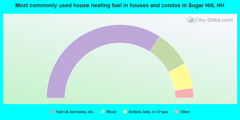
- 68.3%Fuel oil, kerosene, etc.
- 16.1%Wood
- 11.2%Bottled, tank, or LP gas
- 2.4%Electricity
- 1.0%Coal or coke
- 1.0%Solar energy
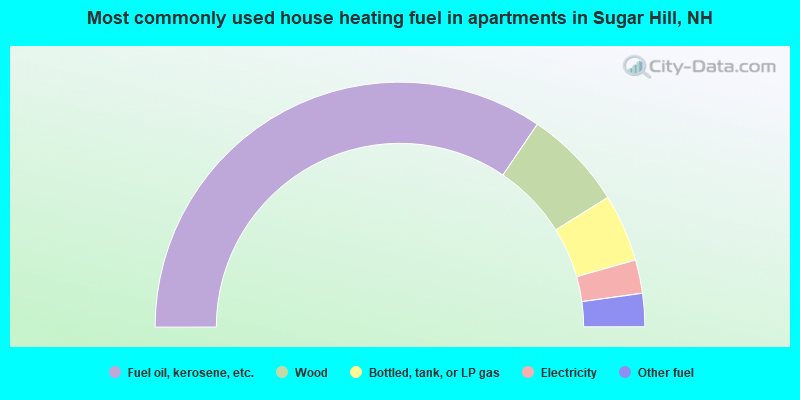
- 68.9%Fuel oil, kerosene, etc.
- 13.3%Wood
- 8.9%Bottled, tank, or LP gas
- 4.4%Electricity
- 4.4%Other fuel
Sugar Hill compared to New Hampshire state average:
- Unemployed percentage significantly below state average.
- Black race population percentage significantly below state average.
- Hispanic race population percentage below state average.
- Median age significantly above state average.
- Foreign-born population percentage below state average.
- Renting percentage below state average.
- Length of stay since moving in significantly above state average.
- Number of rooms per house significantly below state average.
- House age significantly below state average.
- Number of college students below state average.
- Percentage of population with a bachelor's degree or higher above state average.

|
Total of 17 patent applications in 2008-2024.