Mayfield, Georgia
Submit your own pictures of this place and show them to the world
- OSM Map
- General Map
- Google Map
- MSN Map

| Males: 413 | |
| Females: 574 |
| Median resident age: | 35.8 years |
| Georgia median age: | 33.4 years |
Zip code: 31087
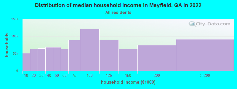
| Mayfield: | $28,042 |
| GA: | $72,837 |
Estimated per capita income in 2022: $22,801 (it was $12,437 in 2000)
Mayfield CCD income, earnings, and wages data
Estimated median house or condo value in 2022: $128,855 (it was $53,100 in 2000)
| Mayfield: | $128,855 |
| GA: | $297,400 |
Detailed information about poverty and poor residents in Mayfield, GA
Compare current foreclosures near Mayfield, GA:
| Photo | Address | Area | Beds / Baths | Price | Details |
|---|---|---|---|---|---|

|
#1
Maiden Ln
Sparta, GA 31087
|
2,200 sq. feet
|
4 baths 3 beds |
show details | |

|
#2
Ghettis St
Sparta, GA 31087
|
1,458 sq. feet
|
1 baths 3 beds |
show details | |

|
#3
Fairmont Rd
Sparta, GA 31087
|
1,011 sq. feet
|
2 baths 3 beds |
show details | |

|
#4
T Tucker Rd
Sparta, GA 31087
|
2,432 sq. feet
|
2 baths 3 beds |
show details | |

|
#5
Sparrow Rd
Sparta, GA 31087
|
1,848 sq. feet
|
2 baths - beds |
show details | |

|
#6
Daisy Ct
Sparta, GA 31087
|
1,904 sq. feet
|
2 baths - beds |
show details | |

|
#7
W Gibson St
Warrenton, GA 30828
|
1,134 sq. feet
|
1 baths - beds |
show details | |

|
#8
Parham St
Warrenton, GA 30828
|
1,480 sq. feet
|
1 baths - beds |
show details | |

|
#9
Willards Way
Warrenton, GA 30828
|
1,104 sq. feet
|
2 baths - beds |
show details | |

|
#10
Highway 15 S
White Plains, GA 30678
|
1,377 sq. feet
|
2 baths - beds |
show details |
| Photo | Address | Area | Beds / Baths | Price | Details |
|---|---|---|---|---|---|

|
#11
Ga Highway 22
Sparta, GA 31087
|
1,680 sq. feet
|
2 baths - beds |
show details | |

|
#12
Linton Rd
Sparta, GA 31087
|
2,240 sq. feet
|
2 baths - beds |
show details | |

|
#13
Jail House Rd
Sparta, GA 31087
|
1,680 sq. feet
|
2 baths - beds |
show details | |

|
#14
Railroad St
Warrenton, GA 30828
|
1,470 sq. feet
|
1 baths - beds |
show details | |

|
#15
Ga Highway 22
Sparta, GA 31087
|
2,432 sq. feet
|
2 baths - beds |
show details | |

|
#16
Alexander St SW
Crawfordville, GA 30631
|
600 sq. feet
|
1 baths - beds |
show details | |

|
#17
Mayo Rd
Norwood, GA 30821
|
1,274 sq. feet
|
2 baths - beds |
show details | |

|
#18
White Plains Rd SW
White Plains, GA 30678
|
1,300 sq. feet
|
1 baths - beds |
show details | |

|
#19
Eley Rd
Gibson, GA 30810
|
- sq. feet
|
- baths - beds |
show details | |

|
#20
Ponderosa Ln
Warrenton, GA 30828
|
- sq. feet
|
- baths - beds |
show details |
| Photo | Address | Area | Beds / Baths | Price | Details |
|---|---|---|---|---|---|

|
#21
Dean St
Gibson, GA 30810
|
- sq. feet
|
1 baths - beds |
show details | |

|
#22
Country Ln
Mitchell, GA 30820
|
- sq. feet
|
- baths - beds |
show details | |

|
#23
Double Wells Rd SE
Crawfordville, GA 30631
|
- sq. feet
|
- baths - beds |
show details | |

|
#24
Evergreen Ave
Warrenton, GA 30828
|
- sq. feet
|
2 baths - beds |
show details | |

|
#25
Hudgeons Rd
Warrenton, GA 30828
|
- sq. feet
|
- baths - beds |
show details | |

|
#26
Oak St
Warrenton, GA 30828
|
- sq. feet
|
- baths - beds |
show details | |

|
#27
Henry Dr
Norwood, GA 30821
|
- sq. feet
|
- baths - beds |
show details | |

|
#28
Hubert St
Warrenton, GA 30828
|
- sq. feet
|
- baths - beds |
show details | |

|
#29
Shoals Rd
Sparta, GA 31087
|
- sq. feet
|
- baths - beds |
show details | |

|
#30
Howell Rd
Warrenton, GA 30828
|
- sq. feet
|
- baths - beds |
show details |
| Photo | Address | Area | Beds / Baths | Price | Details |
|---|---|---|---|---|---|

|
#31
22 Hwy
Sparta, GA 31087
|
- sq. feet
|
- baths - beds |
show details | |

|
#32
Pumping Station Rd
Sparta, GA 31087
|
- sq. feet
|
- baths - beds |
show details | |

|
#33
Beall Springs Rd
Warrenton, GA 30828
|
- sq. feet
|
- baths - beds |
show details | |

|
#34
Hamilton St
Sparta, GA 31087
|
- sq. feet
|
- baths - beds |
show details | |

|
#35
School House Acres
Sparta, GA 31087
|
- sq. feet
|
- baths - beds |
show details | |

|
#36
Oak St
Sparta, GA 31087
|
- sq. feet
|
- baths - beds |
show details | |

|
#37
S Gibson St
Warrenton, GA 30828
|
- sq. feet
|
- baths - beds |
show details | |

|
#38
Calvin Dr
Warrenton, GA 30828
|
- sq. feet
|
- baths - beds |
show details | |

|
#39
English Dr
Warrenton, GA 30828
|
- sq. feet
|
- baths - beds |
show details | |

|
#40
Maggie Reynolds Rd
Sparta, GA 31087
|
- sq. feet
|
- baths - beds |
show details |
| Photo | Address | Area | Beds / Baths | Price | Details |
|---|---|---|---|---|---|

|
Check over 1 million property listings on Foreclosure.com!
|
browse all offers | |||
| Photo | Address | Area | Beds / Baths | Price | Details |
|---|

- 83781.1%Black alone
- 18818.2%White alone
- 50.5%Two or more races
- 20.2%Hispanic
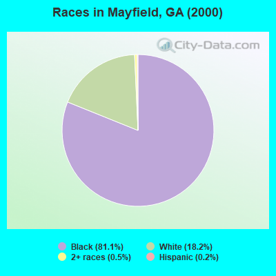
Races in Mayfield detailed stats: ancestries, foreign born residents, place of birth
 Recent articles from our blog. Our writers, many of them Ph.D. graduates or candidates, create easy-to-read articles on a wide variety of topics.
Current Local Time: EST time zone
Elevation: 410 feet
Land area: 100.8 square miles.
Population density: 9.8 people per square mile (very low).

| Mayfield CCD: | 0.8% ($420) |
| Georgia: | 0.9% ($919) |
Nearest city with pop. 50,000+: Augusta-Richmond County, GA  (48.0 miles , pop. 195,182).
Nearest city with pop. 200,000+: Atlanta, GA (94.4 miles , pop. 416,474).
Nearest city with pop. 1,000,000+: Philadelphia, PA (627.8 miles , pop. 1,517,550).
Nearest cities:
), )Latitude: 33.34 N, Longitude: 82.85 W
Area code commonly used in this area: 706

| Here: | 5.4% |
| Georgia: | 2.9% |
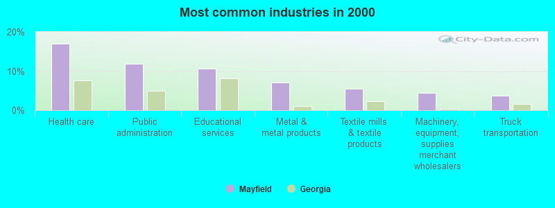
- Health care (17.1%)
- Public administration (11.9%)
- Educational services (10.6%)
- Metal & metal products (7.2%)
- Textile mills & textile products (5.5%)
- Machinery, equipment, supplies merchant wholesalers (4.4%)
- Truck transportation (3.8%)
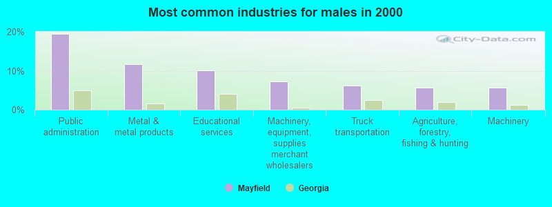
- Public administration (19.6%)
- Metal & metal products (11.7%)
- Educational services (10.1%)
- Machinery, equipment, supplies merchant wholesalers (7.3%)
- Truck transportation (6.1%)
- Agriculture, forestry, fishing & hunting (5.6%)
- Machinery (5.6%)
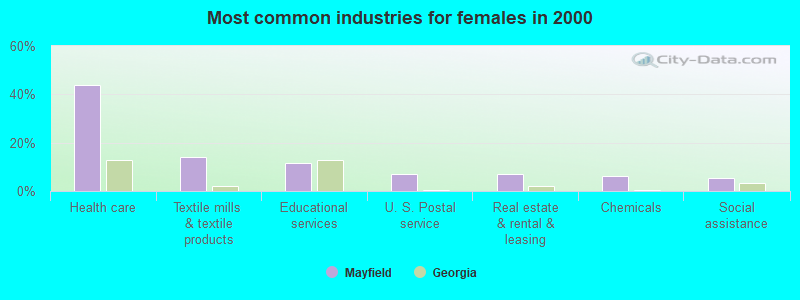
- Health care (43.9%)
- Textile mills & textile products (14.0%)
- Educational services (11.4%)
- U. S. Postal service (7.0%)
- Real estate & rental & leasing (7.0%)
- Chemicals (6.1%)
- Social assistance (5.3%)
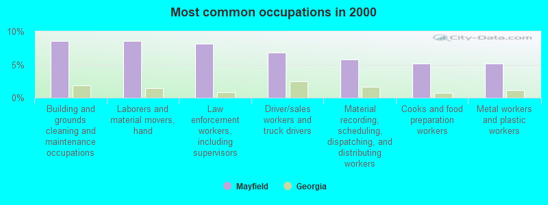
- Building and grounds cleaning and maintenance occupations (8.5%)
- Laborers and material movers, hand (8.5%)
- Law enforcement workers, including supervisors (8.2%)
- Driver/sales workers and truck drivers (6.8%)
- Material recording, scheduling, dispatching, and distributing workers (5.8%)
- Cooks and food preparation workers (5.1%)
- Metal workers and plastic workers (5.1%)

- Law enforcement workers, including supervisors (13.4%)
- Driver/sales workers and truck drivers (11.2%)
- Building and grounds cleaning and maintenance occupations (10.1%)
- Metal workers and plastic workers (8.4%)
- Vehicle and mobile equipment mechanics, installers, and repairers (7.3%)
- Other office and administrative support workers, including supervisors (6.1%)
- Other sales and related occupations, including supervisors (5.6%)

- Laborers and material movers, hand (14.0%)
- Food and beverage serving workers, except waiters and waitresses (11.4%)
- Registered nurses (9.6%)
- Other healthcare support occupations (8.8%)
- Counselors, social workers, and other community and social service specialists (7.9%)
- Other management occupations, except farmers and farm managers (7.0%)
- Material recording, scheduling, dispatching, and distributing workers (7.0%)
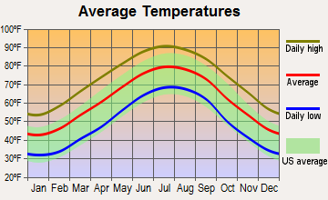
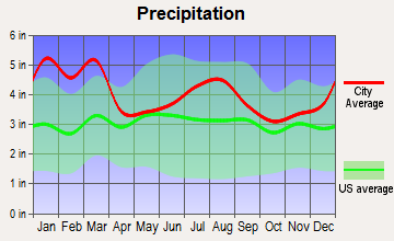
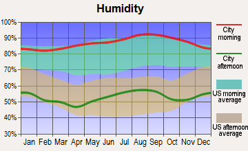
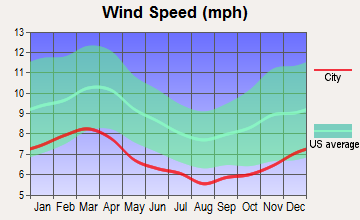
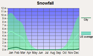
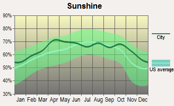
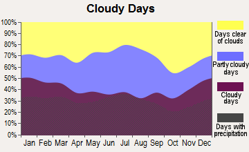
Average climate in Mayfield, Georgia
Based on data reported by over 4,000 weather stations
Tornado activity:
Mayfield-area historical tornado activity is slightly below Georgia state average. It is 5% smaller than the overall U.S. average.
On 11/22/1992, a category F4 (max. wind speeds 207-260 mph) tornado 14.1 miles away from the Mayfield place center killed 5 people and injured 86 people and caused between $5,000,000 and $50,000,000 in damages.
On 11/22/1992, a category F3 (max. wind speeds 158-206 mph) tornado 31.8 miles away from the place center killed one person and injured 9 people and caused between $500,000 and $5,000,000 in damages.
Earthquake activity:
Mayfield-area historical earthquake activity is significantly above Georgia state average. It is 2% greater than the overall U.S. average.On 8/2/1974 at 08:52:09, a magnitude 4.9 (4.3 MB, 4.9 LG, Class: Light, Intensity: IV - V) earthquake occurred 42.4 miles away from the city center
On 4/29/2003 at 08:59:39, a magnitude 4.9 (4.4 MB, 4.6 MW, 4.9 LG) earthquake occurred 178.7 miles away from the city center
On 11/22/1974 at 05:25:55, a magnitude 4.7 (4.7 MB) earthquake occurred 159.3 miles away from the city center
On 8/9/2020 at 12:07:37, a magnitude 5.1 (5.1 MW, Depth: 4.7 mi, Class: Moderate, Intensity: VI - VII) earthquake occurred 238.8 miles away from the city center
On 2/15/2014 at 03:23:38, a magnitude 4.1 (4.1 MW, Depth: 3.2 mi) earthquake occurred 54.7 miles away from Mayfield center
On 11/30/1973 at 07:48:41, a magnitude 4.7 (4.7 MB, 4.6 ML) earthquake occurred 181.8 miles away from the city center
Magnitude types: regional Lg-wave magnitude (LG), body-wave magnitude (MB), local magnitude (ML), moment magnitude (MW)
Natural disasters:
The number of natural disasters in Hancock County (7) is smaller than the US average (15).Major Disasters (Presidential) Declared: 3
Emergencies Declared: 3
Causes of natural disasters: Hurricanes: 2, Winter Storms: 2, Drought: 1, Storm: 1, Tornado: 1, Other: 1 (Note: some incidents may be assigned to more than one category).
Colleges/universities with over 2000 students nearest to Mayfield:
- Georgia Military College-Distance Learning Campuses (about 29 miles; Milledgeville, GA; Full-time enrollment: 6,438)
- Georgia College and State University (about 29 miles; Milledgeville, GA; FT enrollment: 6,271)
- Augusta Technical College (about 47 miles; Augusta, GA; FT enrollment: 3,494)
- Georgia Regents University (about 51 miles; Augusta, GA; FT enrollment: 6,862)
- University of Georgia (about 53 miles; Athens, GA; FT enrollment: 32,679)
- Athens Technical College (about 54 miles; Athens, GA; FT enrollment: 3,204)
- Mercer University (about 59 miles; Macon, GA; FT enrollment: 6,297)
Points of interest:
Notable location: Fish Hatchery (A). Display/hide its location on the map
Churches in Mayfield include: Culverton Church (A), Horeb Church (B), New Hope Church (C), Hickory Grove Church (D), Saint Louis Church (E), Thankful Church (F), Jewell Baptist Church (G), Powelton Baptist Church (H), Powelton Methodist Church (I). Display/hide their locations on the map
Cemeteries: Battle-Cato Cemetery (1), Burnley Cemetery (2), Culverton Cemetery (3), Dunns Cemetery (4), Hickory Grove Cemetery (5), Horeb Cemetery (6), Jewell Cemetery (7). Display/hide their locations on the map
Reservoirs: Aiken Pond (A), Hale Lake (B), Browns Lake (C), Reservoir Lake (D), Dixon Pond (E). Display/hide their locations on the map
Streams, rivers, and creeks: Turkey Creek (A), Hunnon Branch (B), Beaverdam Creek (C), Battle Branch (D), Long Creek (E). Display/hide their locations on the map
Parks in Mayfield include: Jewel Historic District (1), William Rabun Monument (2). Display/hide their locations on the map
| This place: | 2.5 people |
| Georgia: | 2.6 people |
| This place: | 69.3% |
| Whole state: | 68.5% |
| This place: | 4.0% |
| Whole state: | 5.9% |
No gay or lesbian households reported
| This place: | 31.9% |
| Whole state: | 13.0% |
| This place: | 19.4% |
| Whole state: | 6.1% |
For population 15 years and over in Mayfield:
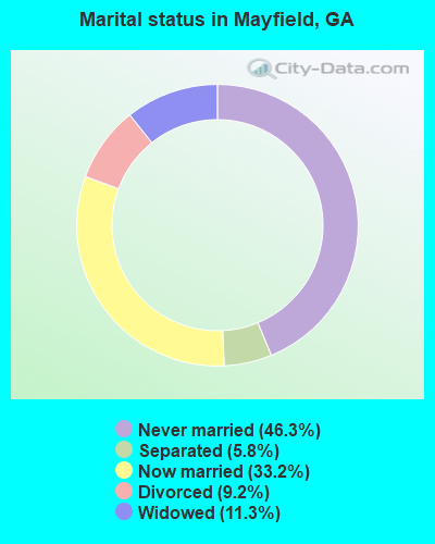
- Never married: 46.3%
- Now married: 33.2%
- Separated: 5.8%
- Widowed: 11.3%
- Divorced: 9.2%
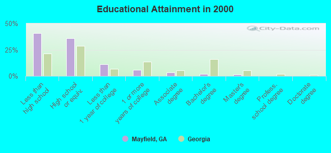
For population 25 years and over in Mayfield:
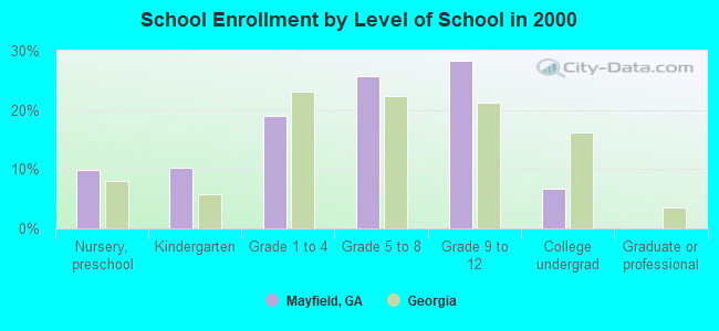
- High school or higher: 59.2%
- Bachelor's degree or higher: 3.1%
- Graduate or professional degree: 1.3%
- Unemployed: 18.8%
- Mean travel time to work (commute): 42.3 minutes
| Here: | 17.6 |
| Georgia average: | 13.3 |
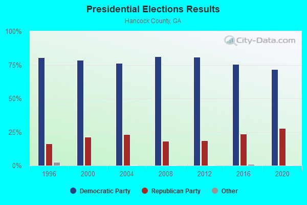
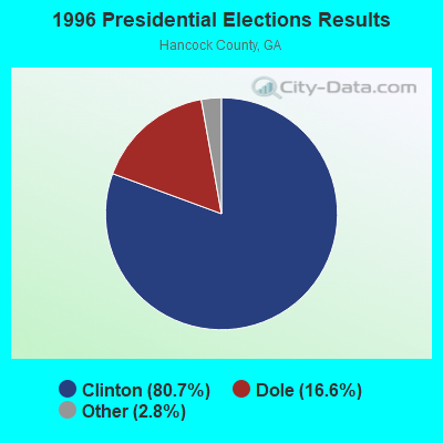


Graphs represent county-level data. Detailed 2008 Election Results
Religion statistics for Mayfield, GA (based on Hancock County data)
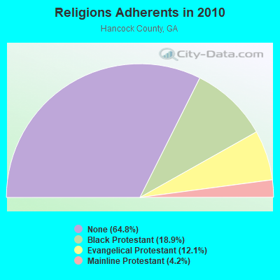
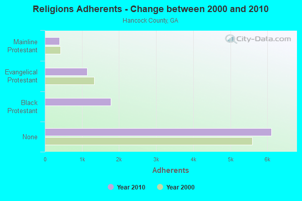
| Religion | Adherents | Congregations |
|---|---|---|
| Black Protestant | 1,779 | 12 |
| Evangelical Protestant | 1,139 | 13 |
| Mainline Protestant | 397 | 6 |
| Other | 6 | 1 |
| None | 6,108 | - |
Food Environment Statistics:
| Hancock County: | 1.05 / 10,000 pop. |
| Georgia: | 1.91 / 10,000 pop. |
| Hancock County: | 1.05 / 10,000 pop. |
| State: | 0.86 / 10,000 pop. |
| Hancock County: | 7.32 / 10,000 pop. |
| Georgia: | 5.12 / 10,000 pop. |
| Here: | 13.9% |
| Georgia: | 10.4% |
| Hancock County: | 34.7% |
| Georgia: | 27.8% |
| Hancock County: | 13.1% |
| Georgia: | 14.6% |
Strongest AM radio stations in Mayfield:
- WMAC (940 AM; 50 kW; MACON, GA; Owner: CUMULUS LICENSING CORP.)
- WSB (750 AM; 50 kW; ATLANTA, GA; Owner: CXR HOLDINGS, INC.)
- WCNN (680 AM; 50 kW; NORTH ATLANTA, GA; Owner: DICKEY BROADCASTING COMPANY)
- WGST (640 AM; 50 kW; ATLANTA, GA; Owner: CITICASTERS LICENSES, L.P.)
- WGUN (1010 AM; 50 kW; ATLANTA, GA; Owner: WGUN, INC.)
- WLFJ (660 AM; daytime; 50 kW; GREENVILLE, SC; Owner: CLEAR CHANNEL BROADCASTING LICENSES, INC.)
- WBAJ (890 AM; daytime; 50 kW; BLYTHEWOOD, SC; Owner: FAMILY FIRST)
- WQXI (790 AM; 28 kW; ATLANTA, GA; Owner: JEFFERSON-PILOT COMMUNICATIONS COMPANY OF GEORGIA)
- WGAC (580 AM; 5 kW; AUGUSTA, GA; Owner: WGAC LICENSE, LLC)
- WAOK (1380 AM; 50 kW; ATLANTA, GA; Owner: INFINITY BROADCASTING OPERATIONS, INC.)
- WMLB (1160 AM; 50 kW; EAST POINT, GA; Owner: ATLANTA AREA BROADCASTING, INC.)
- WCSZ (1070 AM; 50 kW; SANS SOUCI, SC; Owner: WHYZ RADIO, L.P.)
- WXJO (1120 AM; daytime; 10 kW; GORDON, GA; Owner: ROBERTS COMMUNICATIONS, INC.)
Strongest FM radio stations in Mayfield:
- WAKB (96.9 FM; WRENS, GA; Owner: RADIO ONE OF AUGUSTA, LLC)
- WLRR (100.7 FM; MILLEDGEVILLE, GA; Owner: PRESTON W. SMALL)
- WRFN (93.1 FM; WARRENTON, GA; Owner: WCHZ LICENSE, LLC)
- WMGZ (97.7 FM; EATONTON, GA; Owner: MIDDLE GEORGIA COMMUNICATIONS, INC.)
- WJDS (88.7 FM; SPARTA, GA; Owner: AUGUSTA RADIO FELLOWSHIP INSTITUTE INC)
- WCHZ (95.1 FM; HARLEM, GA; Owner: WCHZ LICENSE,LLC)
- WPMA (102.7 FM; BUCKHEAD, GA; Owner: BARINOWSKI INVESTMENT COMPANY, L.P.)
- WTHO-FM (101.7 FM; THOMSON, GA; Owner: CAMELLIA CITY COMMUNICATIONS, INC.)
- WDDK (103.9 FM; GREENSBORO, GA; Owner: BRIARPATCH RADIO INC.)
TV broadcast stations around Mayfield:
- WCES-TV (Channel 20; WRENS, GA; Owner: GEORGIA PUBLIC TELECOMMUNICATIONS COMMISSION)
- National Bridge Inventory (NBI) Statistics
- 1Number of bridges
- 59ft / 18.3mTotal length
- $3,516,000Total costs
- 2,390Total average daily traffic
- 23Total average daily truck traffic
- 3,585Total future (year 2031) average daily traffic
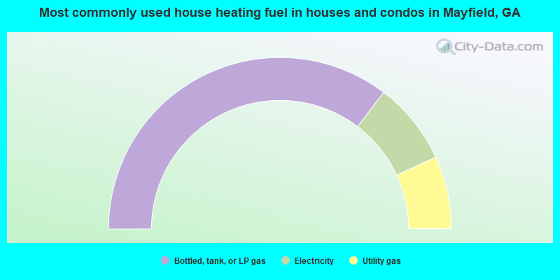
- 70.6%Bottled, tank, or LP gas
- 15.6%Electricity
- 13.7%Utility gas
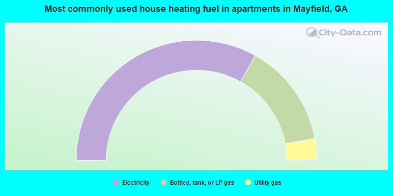
- 66.2%Electricity
- 27.9%Bottled, tank, or LP gas
- 5.8%Utility gas
Mayfield compared to Georgia state average:
- Median household income significantly below state average.
- Median house value significantly below state average.
- Black race population percentage above state average.
- Hispanic race population percentage significantly below state average.
- Foreign-born population percentage significantly below state average.
- Length of stay since moving in significantly above state average.
- Number of rooms per house significantly below state average.
- House age significantly below state average.
- Number of college students below state average.
- Percentage of population with a bachelor's degree or higher significantly below state average.