Warthen, Georgia
Submit your own pictures of this place and show them to the world
- OSM Map
- General Map
- Google Map
- MSN Map

| Males: 526 | |
| Females: 554 |
| Median resident age: | 36.9 years |
| Georgia median age: | 33.4 years |
Zip code: 31094
| Warthen: | $41,650 |
| GA: | $72,837 |
Estimated per capita income in 2022: $23,355 (it was $15,130 in 2000)
Warthen CCD income, earnings, and wages data
Estimated median house or condo value in 2022: $120,539 (it was $49,000 in 2000)
| Warthen: | $120,539 |
| GA: | $297,400 |
Mean prices in 2022: all housing units: $200,075; detached houses: $223,964; townhouses or other attached units: $295,404; mobile homes: $126,828
Detailed information about poverty and poor residents in Warthen, GA


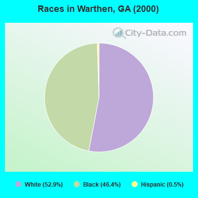
- 58052.9%White alone
- 50846.4%Black alone
- 60.5%Hispanic
- 10.09%American Indian alone
- 10.09%Other race alone
Races in Warthen detailed stats: ancestries, foreign born residents, place of birth
According to our research of Georgia and other state lists, there was 1 registered sex offender living in Warthen, Georgia as of April 26, 2024.
The ratio of all residents to sex offenders in Warthen is 1,080 to 1.
The ratio of registered sex offenders to all residents in this city is much lower than the state average.
 Recent articles from our blog. Our writers, many of them Ph.D. graduates or candidates, create easy-to-read articles on a wide variety of topics.
Current Local Time: EST time zone
Elevation: 475 feet
Land area: 108.4 square miles.
Population density: 10.0 people per square mile (very low).

| Warthen CCD: | 0.9% ($450) |
| Georgia: | 0.9% ($919) |
Nearest city with pop. 50,000+: Augusta-Richmond County, GA  (49.1 miles , pop. 195,182).
Nearest city with pop. 200,000+: Atlanta, GA (103.0 miles , pop. 416,474).
Nearest city with pop. 1,000,000+: Philadelphia, PA (636.8 miles , pop. 1,517,550).
Nearest cities:
), ), ), ), )Latitude: 33.13 N, Longitude: 82.79 W
Area code commonly used in this area: 478

| Here: | 4.0% |
| Georgia: | 2.9% |
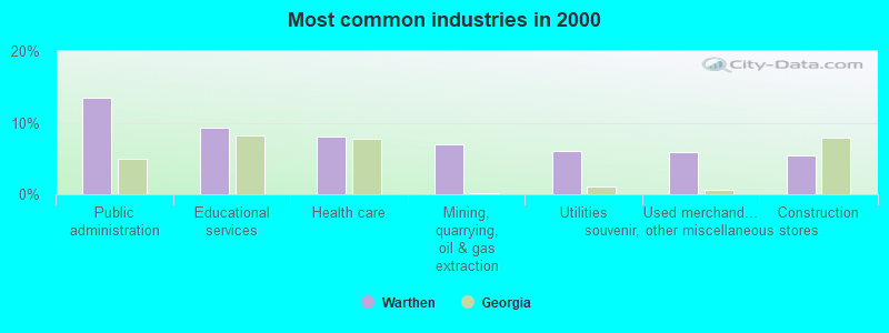
- Public administration (13.5%)
- Educational services (9.2%)
- Health care (8.1%)
- Mining, quarrying, oil & gas extraction (7.0%)
- Utilities (6.1%)
- Used merchandise, gift, novelty, souvenir, other miscellaneous stores (5.9%)
- Construction (5.4%)
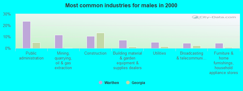
- Public administration (23.7%)
- Mining, quarrying, oil & gas extraction (11.6%)
- Construction (10.7%)
- Building material & garden equipment & supplies dealers (7.1%)
- Utilities (5.4%)
- Broadcasting & telecommunications (4.5%)
- Furniture & home furnishings, household appliance stores (4.5%)
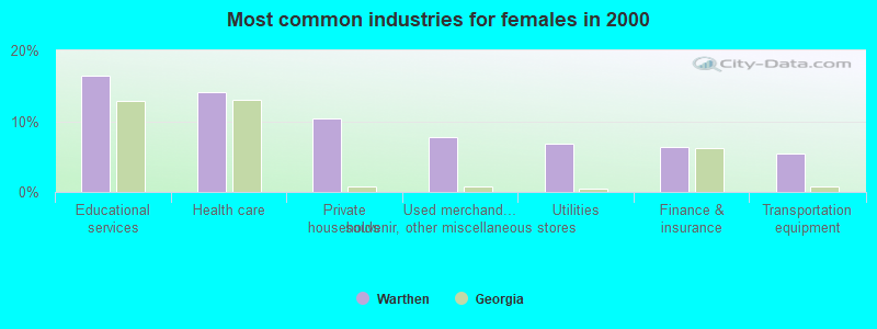
- Educational services (16.4%)
- Health care (14.1%)
- Private households (10.5%)
- Used merchandise, gift, novelty, souvenir, other miscellaneous stores (7.7%)
- Utilities (6.8%)
- Finance & insurance (6.4%)
- Transportation equipment (5.5%)
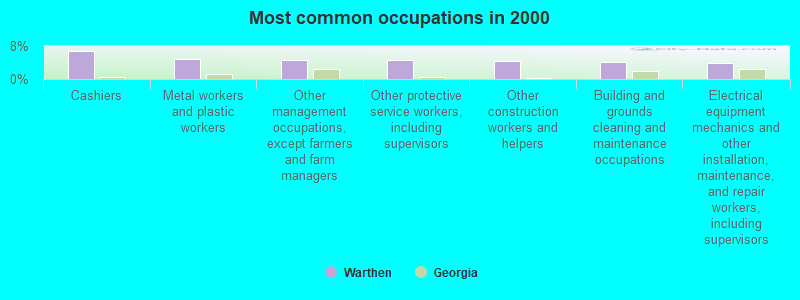
- Cashiers (6.8%)
- Metal workers and plastic workers (4.7%)
- Other management occupations, except farmers and farm managers (4.5%)
- Other protective service workers, including supervisors (4.5%)
- Other construction workers and helpers (4.3%)
- Building and grounds cleaning and maintenance occupations (4.1%)
- Electrical equipment mechanics and other installation, maintenance, and repair workers, including supervisors (3.8%)
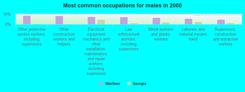
- Other protective service workers, including supervisors (8.9%)
- Other construction workers and helpers (8.5%)
- Electrical equipment mechanics and other installation, maintenance, and repair workers, including supervisors (7.6%)
- Law enforcement workers, including supervisors (7.1%)
- Metal workers and plastic workers (6.7%)
- Laborers and material movers, hand (5.8%)
- Supervisors, construction and extraction workers (4.9%)
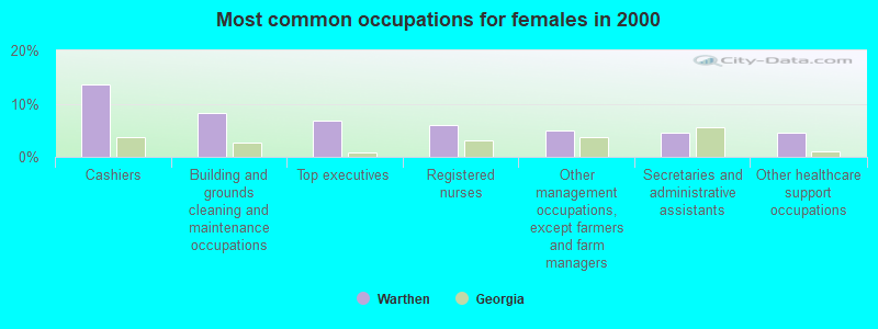
- Cashiers (13.6%)
- Building and grounds cleaning and maintenance occupations (8.2%)
- Top executives (6.8%)
- Registered nurses (5.9%)
- Other management occupations, except farmers and farm managers (5.0%)
- Secretaries and administrative assistants (4.5%)
- Other healthcare support occupations (4.5%)
Average climate in Warthen, Georgia
Based on data reported by over 4,000 weather stations


(lower is better)
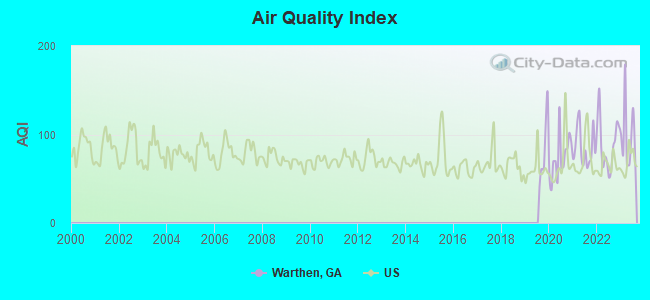
Air Quality Index (AQI) level in 2023 was 98.1. This is worse than average.
| City: | 98.1 |
| U.S.: | 72.6 |
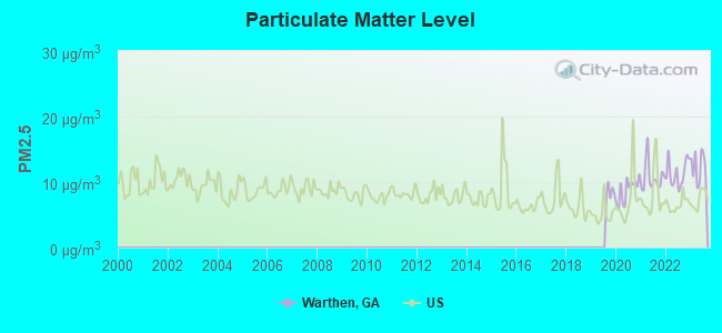
Particulate Matter (PM2.5) [µg/m3] level in 2023 was 12.2. This is significantly worse than average. Closest monitor was 11.1 miles away from the city center.
| City: | 12.2 |
| U.S.: | 8.1 |
Tornado activity:
Warthen-area historical tornado activity is slightly below Georgia state average. It is 8% smaller than the overall U.S. average.
On 11/22/1992, a category F4 (max. wind speeds 207-260 mph) tornado 27.6 miles away from the Warthen place center killed 5 people and injured 86 people and caused between $5,000,000 and $50,000,000 in damages.
On 1/13/1972, a category F3 (max. wind speeds 158-206 mph) tornado 29.5 miles away from the place center injured 21 people and caused between $500,000 and $5,000,000 in damages.
Earthquake activity:
Warthen-area historical earthquake activity is significantly above Georgia state average. It is 3% smaller than the overall U.S. average.On 8/2/1974 at 08:52:09, a magnitude 4.9 (4.3 MB, 4.9 LG, Class: Light, Intensity: IV - V) earthquake occurred 54.4 miles away from the city center
On 4/29/2003 at 08:59:39, a magnitude 4.9 (4.4 MB, 4.6 MW, 4.9 LG) earthquake occurred 188.7 miles away from Warthen center
On 11/22/1974 at 05:25:55, a magnitude 4.7 (4.7 MB) earthquake occurred 154.0 miles away from Warthen center
On 8/9/2020 at 12:07:37, a magnitude 5.1 (5.1 MW, Depth: 4.7 mi, Class: Moderate, Intensity: VI - VII) earthquake occurred 250.8 miles away from Warthen center
On 2/15/2014 at 03:23:38, a magnitude 4.1 (4.1 MW, Depth: 3.2 mi) earthquake occurred 62.3 miles away from the city center
On 11/30/1973 at 07:48:41, a magnitude 4.7 (4.7 MB, 4.6 ML) earthquake occurred 196.6 miles away from the city center
Magnitude types: regional Lg-wave magnitude (LG), body-wave magnitude (MB), local magnitude (ML), moment magnitude (MW)
Natural disasters:
The number of natural disasters in Washington County (9) is smaller than the US average (15).Major Disasters (Presidential) Declared: 4
Emergencies Declared: 4
Causes of natural disasters: Winter Storms: 3, Hurricanes: 2, Drought: 1, Flood: 1, Snowfall: 1, Tropical Storm: 1, Other: 1 (Note: some incidents may be assigned to more than one category).
Hospitals and medical centers near Warthen:
- HERITAGE INN OF SANDERSVILLE HEALTH AND REHAB (Nursing Home, about 10 miles away; SANDERSVILLE, GA)
- WASHINGTON COUNTY REGIONAL MEDICAL CENTER Acute Care Hospitals (about 10 miles away; SANDERSVILLE, GA)
- WASHINGTON CO ECF (Nursing Home, about 10 miles away; SANDERSVILLE, GA)
- WASHINGTON CO EXTENDED CARE FA (Nursing Home, about 10 miles away; SANDERSVILLE, GA)
- COMFORT CARE (Hospital, about 10 miles away; SANDERSVILLE, GA)
- SMITH MEDICAL NURSING CARE CTR (Nursing Home, about 10 miles away; SANDERSVILLE, GA)
- RAWLINGS NH (Nursing Home, about 11 miles away; SANDERSVILLE, GA)
Colleges/universities with over 2000 students nearest to Warthen:
- Georgia Military College-Distance Learning Campuses (about 26 miles; Milledgeville, GA; Full-time enrollment: 6,438)
- Georgia College and State University (about 26 miles; Milledgeville, GA; FT enrollment: 6,271)
- East Georgia State College (about 47 miles; Swainsboro, GA; FT enrollment: 2,345)
- Augusta Technical College (about 48 miles; Augusta, GA; FT enrollment: 3,494)
- Georgia Regents University (about 52 miles; Augusta, GA; FT enrollment: 6,862)
- Mercer University (about 55 miles; Macon, GA; FT enrollment: 6,297)
- Middle Georgia State College (about 60 miles; Macon, GA; FT enrollment: 7,091)
Points of interest:
Notable location: Warthen Volunteer Fire Department (A). Display/hide its location on the map
Churches in Warthen include: Chapel Church (A), Warthen United Methodist Church (B), Holly Spring Church (C), Mineral Springs Church (D), Mount Olive Church (E), New Hope Church (F), Pine Hill Church (G), Saint James Church (H), Bethlehem Church (I). Display/hide their locations on the map
Cemeteries: Amerson Cemetery (1), Antioch Cemetery (2), Bethlehem Cemetery (3), Burgamy Cemetery (4), John Sparks Cemetery (5), Mineral Springs Cemetery (6), Union Cemetery (7). Display/hide their locations on the map
Reservoirs: Burgamy Millpond (A), Hamburg Millpond (B), Brown Lake (C), Archers Lakes (D), Chalker Lake (E), Mays Millpond (F), Shephard Lake (G), Hamburg Mill Pond (H). Display/hide their locations on the map
Streams, rivers, and creeks: Stephens Creek (A), Stabley Branch (B), Cowpen Creek (C), Floyd Creek (D), Reynolds Branch (E), Paul Creek (F), Patterson Creek (G), Parker Branch (H), Alligator Branch (I). Display/hide their locations on the map
Park in Warthen: Hamburg State Park (1). Display/hide its location on the map
Birthplace of: Josh Gordy - Football player.
| This place: | 2.4 people |
| Georgia: | 2.6 people |
| This place: | 67.8% |
| Whole state: | 68.5% |
| This place: | 4.0% |
| Whole state: | 5.9% |
Likely homosexual households (counted as self-reported same-sex unmarried-partner households)
- Lesbian couples: 0.3% of all households
- Gay men: 0.0% of all households
| This place: | 21.5% |
| Whole state: | 13.0% |
| This place: | 10.9% |
| Whole state: | 6.1% |
For population 15 years and over in Warthen:
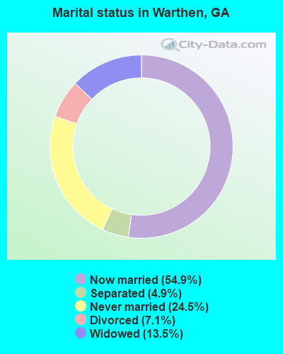
- Never married: 24.5%
- Now married: 54.9%
- Separated: 4.9%
- Widowed: 13.5%
- Divorced: 7.1%
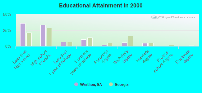
For population 25 years and over in Warthen:
- High school or higher: 64.3%
- Bachelor's degree or higher: 10.4%
- Graduate or professional degree: 4.6%
- Unemployed: 3.1%
- Mean travel time to work (commute): 38.4 minutes
| Here: | 14.6 |
| Georgia average: | 13.3 |
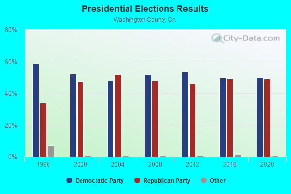


Graphs represent county-level data. Detailed 2008 Election Results
Religion statistics for Warthen, GA (based on Washington County data)
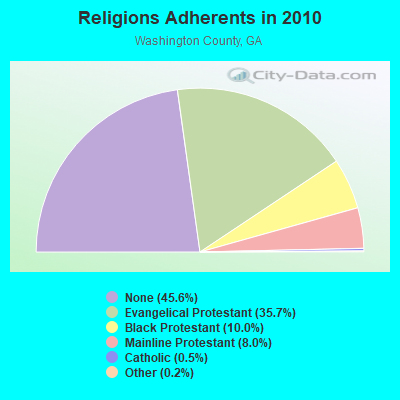
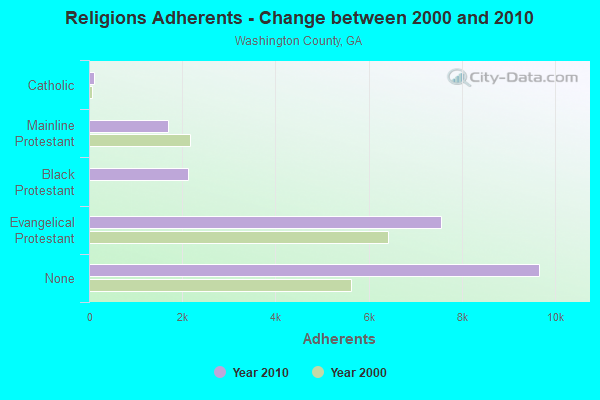
| Religion | Adherents | Congregations |
|---|---|---|
| Evangelical Protestant | 7,562 | 45 |
| Black Protestant | 2,128 | 15 |
| Mainline Protestant | 1,690 | 13 |
| Catholic | 98 | 1 |
| Other | 42 | 2 |
| None | 9,667 | - |
Food Environment Statistics:
| This county: | 1.43 / 10,000 pop. |
| State: | 1.91 / 10,000 pop. |
| Washington County: | 9.55 / 10,000 pop. |
| Georgia: | 5.12 / 10,000 pop. |
| Washington County: | 6.68 / 10,000 pop. |
| Georgia: | 7.41 / 10,000 pop. |
| Washington County: | 12.9% |
| Georgia: | 10.4% |
| Here: | 31.9% |
| Georgia: | 27.8% |
| This county: | 16.4% |
| State: | 14.6% |
Strongest AM radio stations in Warthen:
- WMAC (940 AM; 50 kW; MACON, GA; Owner: CUMULUS LICENSING CORP.)
- WSB (750 AM; 50 kW; ATLANTA, GA; Owner: CXR HOLDINGS, INC.)
- WCNN (680 AM; 50 kW; NORTH ATLANTA, GA; Owner: DICKEY BROADCASTING COMPANY)
- WGST (640 AM; 50 kW; ATLANTA, GA; Owner: CITICASTERS LICENSES, L.P.)
- WSNT (1490 AM; 1 kW; SANDERSVILLE, GA; Owner: RADIO WNST, INC.)
- WGUN (1010 AM; 50 kW; ATLANTA, GA; Owner: WGUN, INC.)
- WLFJ (660 AM; daytime; 50 kW; GREENVILLE, SC; Owner: CLEAR CHANNEL BROADCASTING LICENSES, INC.)
- WXJO (1120 AM; daytime; 10 kW; GORDON, GA; Owner: ROBERTS COMMUNICATIONS, INC.)
- WBAJ (890 AM; daytime; 50 kW; BLYTHEWOOD, SC; Owner: FAMILY FIRST)
- WGAC (580 AM; 5 kW; AUGUSTA, GA; Owner: WGAC LICENSE, LLC)
- WQXI (790 AM; 28 kW; ATLANTA, GA; Owner: JEFFERSON-PILOT COMMUNICATIONS COMPANY OF GEORGIA)
- WMLB (1160 AM; 50 kW; EAST POINT, GA; Owner: ATLANTA AREA BROADCASTING, INC.)
- WAOK (1380 AM; 50 kW; ATLANTA, GA; Owner: INFINITY BROADCASTING OPERATIONS, INC.)
Strongest FM radio stations in Warthen:
- WAKB (96.9 FM; WRENS, GA; Owner: RADIO ONE OF AUGUSTA, LLC)
- WLRR (100.7 FM; MILLEDGEVILLE, GA; Owner: PRESTON W. SMALL)
- WQZY (95.9 FM; DUBLIN, GA; Owner: STATE BROADCASTING CORPORATION)
- WJFL (101.9 FM; TENNILLE, GA; Owner: FALL LINE MEDIA, INC.)
- WSNT-FM (99.9 FM; SANDERSVILLE, GA; Owner: RADIO STATION WSNT, INC.)
- WMGZ (97.7 FM; EATONTON, GA; Owner: MIDDLE GEORGIA COMMUNICATIONS, INC.)
- WCHZ (95.1 FM; HARLEM, GA; Owner: WCHZ LICENSE,LLC)
- WRFN (93.1 FM; WARRENTON, GA; Owner: WCHZ LICENSE, LLC)
- WPEH-FM (92.1 FM; LOUISVILLE, GA; Owner: PEACH BROADCASTING CO., INC.)
- W201BN (88.1 FM; MILLEDGEVILLE, GA; Owner: CALVARY CHAPEL OF TWIN FALLS, INC.)
TV broadcast stations around Warthen:
- WCES-TV (Channel 20; WRENS, GA; Owner: GEORGIA PUBLIC TELECOMMUNICATIONS COMMISSION)
Warthen fatal accident list:
Jun 24, 1984 05:10 PM, 15, Vehicles: 1, Persons: 1, Fatalities: 1, Drunk persons involved: 1
Dec 31, 1976 09:20 PM, Vehicles: 1, Persons: 2, Fatalities: 2
Dec 31, 1975 09:20 PM, Vehicles: 1, Persons: 2, Fatalities: 2
FCC Registered Cell Phone Towers:
1 (See the full list of FCC Registered Cell Phone Towers in Warthen)FCC Registered Antenna Towers:
46 (See the full list of FCC Registered Antenna Towers)FCC Registered Microwave Towers:
4- STATION, On Rd .6 Mi N Of Ga St Hwy 102 4 Mi Ne Of (Lat: 33.152361 Lon: -82.773444), Overall height: 80.8 m, Call Sign: WNEP322,
Assigned Frequencies: 1975.00 MHz, Grant Date: 04/09/1998, Expiration Date: 10/17/2001, Cancellation Date: 04/23/2001, Registrant: Southern Natural Gas Company, 1900 5th Avenue N, Birmingham, AL 35203, Phone: (205) 325-7328, Fax: (205) 325-3730, Email:
- On Road .6 Mi N Of Georgia St Hwy 102 4 Mi Ne (Lat: 33.152361 Lon: -82.773444), Overall height: 80.8 m, Call Sign: WPNM464,
Assigned Frequencies: 1945.00 MHz, Grant Date: 04/09/1998, Expiration Date: 04/09/2008, Cancellation Date: 11/19/2001, Phone: (202) 223-9222
- GE WARTHEN, 16427 N. Sparta Davisboro Road (Lat: 33.127139 Lon: -82.802722), Type: Gtower, Structure height: 97.5 m, Overall height: 100.6 m, Call Sign: WQPZ553,
Assigned Frequencies: 11405.0 MHz, Grant Date: 09/27/2012, Expiration Date: 09/27/2022, Cancellation Date: 12/03/2022, Certifier: Chris Harris, Registrant: Conterra Ultra Broadband, LLC, 2101 Rexford Rd, Ste 200e, Charlotte, NC 28211, Phone: (704) 936-1801, Fax: (704) 936-1801, Email:
- WARTHEN, 16427 North Davidson Road (Lat: 33.126556 Lon: -82.804333), Type: Gtower, Structure height: 121.9 m, Overall height: 124.3 m, Call Sign: WRCB868,
Assigned Frequencies: 11265.0 MHz, 11305.0 MHz, 11265.0 MHz, 11305.0 MHz, 11265.0 MHz, 11305.0 MHz, 11265.0 MHz, 11305.0 MHz, 11265.0 MHz, 11305.0 MHz... (+6 more), Grant Date: 08/21/2018, Expiration Date: 08/21/2028, Certifier: Larry F Butts, Registrant: Southern Company Services, 600 N. 18th St / Bin 5n-5409, Birmingham, AL 35203, Phone: (205) 257-7600, Fax: (205) 257-2134, Email:
FCC Registered Amateur Radio Licenses:
4- Call Sign: KD4SRT, Grant Date: 09/08/1992, Expiration Date: 09/08/2002, Cancellation Date: 09/09/2004, Registrant: David G Brisebois, Rt 1 Box 170, Warthen, GA 31094
- Call Sign: KE4WAV, Grant Date: 02/24/1995, Expiration Date: 02/24/2005, Cancellation Date: 02/27/2007, Registrant: Janet F Gray, Warthen, GA 31094
- Call Sign: KE4WAW, Grant Date: 02/24/1995, Expiration Date: 02/24/2005, Cancellation Date: 02/27/2007, Registrant: Robert C Sullivan, Warthen, GA 31094
- Call Sign: KE4WAX, Grant Date: 02/24/1995, Expiration Date: 02/24/2005, Cancellation Date: 02/27/2007, Registrant: Carolyn C Sullivan, Warthen, GA 31094
FAA Registered Aircraft:
2- Aircraft: WILLIAM LOREN NOGGLE JA30 SUPERSTOL (Category: Land, Seats: 2, Weight: Up to 12,499 Pounds), Engine: ROTAX 912ULS SERIES (100 HP) (Reciprocating)
N-Number: 719LN, N719LN, N-719LN, Serial Number: JA 472-11-15, Year manufactured: 2018, Airworthiness Date: 08/12/2018, Certificate Issue Date: 07/09/2018
Registrant (Individual): William L Noggle, 648 Webster Rd, Warthen, GA 31094 - Aircraft: DAVIS CHARLES JR RV-6A (Category: Land, Seats: 2, Weight: Up to 12,499 Pounds), Engine: LYCOMING I0360 SER A&C (200 HP) (Reciprocating)
N-Number: 771CD, N771CD, N-771CD, Serial Number: 60313, Year manufactured: 2000, Airworthiness Date: 09/12/2000, Certificate Issue Date: 01/23/2015
Registrant (LLC): A B Helton Enterprises LLC, 887 Stephens Creek Rd, Warthen, GA 31094
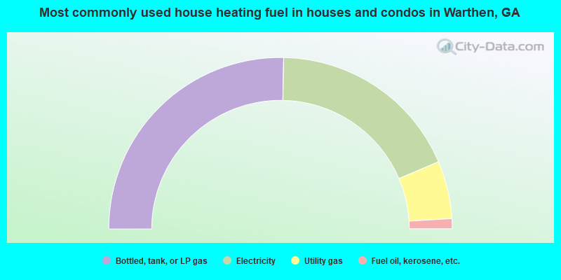
- 50.6%Bottled, tank, or LP gas
- 36.6%Electricity
- 10.9%Utility gas
- 1.9%Fuel oil, kerosene, etc.
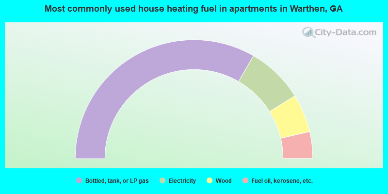
- 66.7%Bottled, tank, or LP gas
- 15.6%Electricity
- 10.4%Wood
- 7.3%Fuel oil, kerosene, etc.
Warthen compared to Georgia state average:
- Median household income below state average.
- Median house value significantly below state average.
- Unemployed percentage significantly below state average.
- Hispanic race population percentage significantly below state average.
- Foreign-born population percentage significantly below state average.
- Renting percentage below state average.
- Length of stay since moving in significantly above state average.
- Number of rooms per house significantly below state average.
- House age significantly below state average.
- Percentage of population with a bachelor's degree or higher below state average.
Warthen on our top lists:
- #82 on the list of "Top 101 cities with the most cars per house, population 500+"