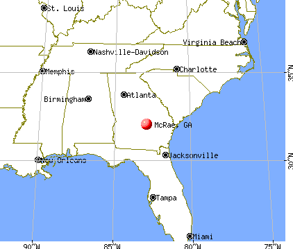
McRae, Georgia

McRae: Little ocmulgee state park
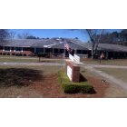
McRae: Friendliest home in McRae !

McRae: Little ocmulgee state park
- add
your
Submit your own pictures of this city and show them to the world
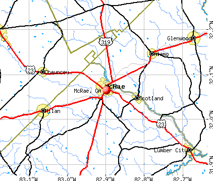
- OSM Map
- General Map
- Google Map
- MSN Map
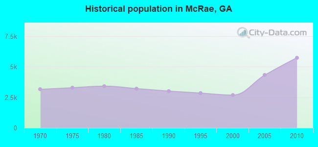
Population change since 2000: +122.7%
| Males: 2,719 | |
| Females: 3,253 |
| Median resident age: | 41.0 years |
| Georgia median age: | 37.6 years |
Zip codes: 31055.
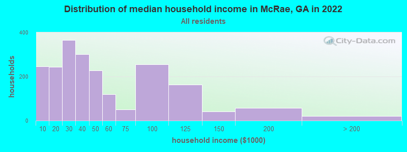
| McRae: | $44,531 |
| GA: | $72,837 |
Estimated per capita income in 2022: $19,509 (it was $15,911 in 2000)
McRae city income, earnings, and wages data
Estimated median house or condo value in 2022: $129,855 (it was $47,600 in 2000)
| McRae: | $129,855 |
| GA: | $297,400 |
Mean prices in 2022: all housing units: $184,314; detached houses: $190,156; mobile homes: $65,325
Median gross rent in 2022: $775.
(14.7% for White Non-Hispanic residents, 47.4% for Black residents)
Detailed information about poverty and poor residents in McRae, GA

Compare current foreclosures near McRae, GA:
| Photo | Address | Area | Beds / Baths | Price | Details |
|---|---|---|---|---|---|

|
#1
Long Bridge Rd
Helena, GA 31037
|
1,818 sq. feet
|
2 baths 3 beds |
show details | |

|
#2
N Broad St
Alamo, GA 30411
|
1,600 sq. feet
|
1 baths - beds |
show details | |

|
#3
Bay St
Mc Rae, GA 31055
|
910 sq. feet
|
1 baths - beds |
show details | |

|
#4
Evergreen Church Rd
Eastman, GA 31023
|
924 sq. feet
|
2 baths - beds |
show details | |

|
#5
Jay Bird Springs Rd
Chauncey, GA 31011
|
1,350 sq. feet
|
1 baths - beds |
show details | |

|
#6
Tom Haley Rd
Lumber City, GA 31549
|
1,660 sq. feet
|
2 baths - beds |
show details | |

|
#7
Lakeview Dr
Alamo, GA 30411
|
1,056 sq. feet
|
1 baths - beds |
show details | |

|
#8
Cravey Store Rd
Milan, GA 31060
|
1,686 sq. feet
|
- baths - beds |
show details | |

|
#9
Highway 441
Mc Rae, GA 31055
|
- sq. feet
|
- baths - beds |
show details | |

|
#10
Landfill Rd
Mc Rae, GA 31055
|
- sq. feet
|
- baths - beds |
show details |
| Photo | Address | Area | Beds / Baths | Price | Details |
|---|---|---|---|---|---|

|
#11
Patrick Rd
Milan, GA 31060
|
- sq. feet
|
- baths - beds |
show details | |

|
#12
S Third Ave, Apt B
Mc Rae, GA 31055
|
- sq. feet
|
- baths - beds |
show details | |

|
#13
Marigold Dr
Chauncey, GA 31011
|
- sq. feet
|
- baths - beds |
show details | |

|
#14
Jim Jake Rd
Jacksonville, GA 31544
|
- sq. feet
|
- baths - beds |
show details | |

|
#15
Opossum Rd
Lumber City, GA 31549
|
- sq. feet
|
- baths - beds |
show details | |

|
#16
SW Third Street
Glenwood, GA 30428
|
- sq. feet
|
- baths - beds |
show details | |

|
#17
Ga-19 S
Glenwood, GA 30428
|
- sq. feet
|
- baths - beds |
show details | |

|
#18
S Martin Luther King Jr St
Lumber City, GA 31549
|
- sq. feet
|
- baths - beds |
show details | |

|
#19
Horne Rd
Eastman, GA 31023
|
- sq. feet
|
- baths - beds |
show details | |

|
#20
Lee St
Milan, GA 31060
|
- sq. feet
|
- baths - beds |
show details |
| Photo | Address | Area | Beds / Baths | Price | Details |
|---|---|---|---|---|---|

|
#21
Towns Rd
Mc Rae, GA 31055
|
- sq. feet
|
- baths - beds |
show details | |

|
#22
Kinnett Rd
Mc Rae, GA 31055
|
- sq. feet
|
- baths - beds |
show details | |

|
#23
Spring Ave
Mc Rae, GA 31055
|
- sq. feet
|
- baths - beds |
show details | |

|
#24
Nellie St
Alamo, GA 30411
|
- sq. feet
|
- baths - beds |
show details | |

|
#25
Old Prison Camp Rd
Mc Rae, GA 31055
|
- sq. feet
|
- baths - beds |
show details | |

|
#26
Main St
Mc Rae, GA 31055
|
- sq. feet
|
- baths - beds |
show details | |

|
#27
Whatley Farm Rd
Helena, GA 31037
|
- sq. feet
|
- baths - beds |
show details | |

|
#28
Blankenship Rd
Mc Rae, GA 31055
|
- sq. feet
|
- baths - beds |
show details | |

|
#29
King St
Helena, GA 31037
|
980 sq. feet
|
- baths - beds |
show details | |

|
#30
Second St
Helena, GA 31037
|
- sq. feet
|
- baths - beds |
show details |
| Photo | Address | Area | Beds / Baths | Price | Details |
|---|---|---|---|---|---|

|
#31
E Ninth St
Helena, GA 31037
|
- sq. feet
|
- baths - beds |
show details | |

|
#32
Bush St
Mc Rae, GA 31055
|
- sq. feet
|
- baths - beds |
show details | |

|
#33
Spaulding Dr
Mc Rae, GA 31055
|
- sq. feet
|
- baths - beds |
show details | |

|
#34
Sawmill Ave
Mc Rae, GA 31055
|
- sq. feet
|
- baths - beds |
show details | |

|
#35
Ag Best Rd
Eastman, GA 31023
|
- sq. feet
|
- baths - beds |
show details | |

|
#36
Batten Ave
Mc Rae, GA 31055
|
- sq. feet
|
- baths - beds |
show details | |

|
Check over 1 million property listings on Foreclosure.com!
|
browse all offers | |||

- 3,22950.8%White alone
- 2,79043.9%Black alone
- 1292.0%Hispanic
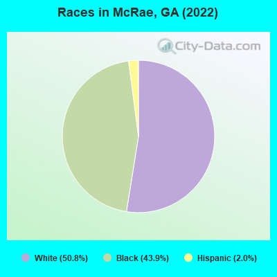
Races in McRae detailed stats: ancestries, foreign born residents, place of birth
According to our research of Georgia and other state lists, there were 33 registered sex offenders living in McRae, Georgia as of April 27, 2024.
The ratio of all residents to sex offenders in McRae is 182 to 1.
Type |
2009 |
2010 |
2011 |
2012 |
2013 |
2014 |
2015 |
2016 |
2017 |
2020 |
2021 |
2022 |
|---|---|---|---|---|---|---|---|---|---|---|---|---|
| Murders (per 100,000) | 0 (0.0) | 0 (0.0) | 0 (0.0) | 0 (0.0) | 0 (0.0) | 0 (0.0) | 0 (0.0) | 0 (0.0) | 0 (0.0) | 0 (0.0) | 0 (0.0) | 0 (0.0) |
| Rapes (per 100,000) | 0 (0.0) | 0 (0.0) | 0 (0.0) | 0 (0.0) | 0 (0.0) | 0 (0.0) | 0 (0.0) | 0 (0.0) | 0 (0.0) | 0 (0.0) | 0 (0.0) | 0 (0.0) |
| Robberies (per 100,000) | 1 (21.5) | 1 (17.4) | 1 (17.2) | 1 (17.6) | 1 (17.9) | 2 (32.6) | 0 (0.0) | 4 (45.5) | 3 (36.2) | 2 (24.3) | 2 (24.2) | 0 (0.0) |
| Assaults (per 100,000) | 28 (602.5) | 18 (313.6) | 11 (189.1) | 22 (387.9) | 16 (286.3) | 22 (358.2) | 5 (82.5) | 9 (102.4) | 8 (96.4) | 9 (109.1) | 9 (109.1) | 18 (306.5) |
| Burglaries (per 100,000) | 39 (839.3) | 19 (331.0) | 22 (378.3) | 14 (246.8) | 25 (447.4) | 29 (472.2) | 53 (874.6) | 35 (398.4) | 35 (421.9) | 21 (254.7) | 14 (169.7) | 18 (306.5) |
| Thefts (per 100,000) | 69 (1,485) | 66 (1,150) | 64 (1,100) | 42 (740.5) | 44 (787.4) | 49 (797.9) | 75 (1,238) | 125 (1,423) | 106 (1,278) | 32 (388.1) | 23 (278.8) | 14 (238.4) |
| Auto thefts (per 100,000) | 7 (150.6) | 5 (87.1) | 2 (34.4) | 2 (35.3) | 2 (35.8) | 4 (65.1) | 3 (49.5) | 1 (11.4) | 2 (24.1) | 6 (72.8) | 6 (72.7) | 1 (17.0) |
| Arson (per 100,000) | 0 (0.0) | 0 (0.0) | 0 (0.0) | 0 (0.0) | 0 (0.0) | 0 (0.0) | 0 (0.0) | 0 (0.0) | 0 (0.0) | 0 (0.0) | 1 (12.1) | 0 (0.0) |
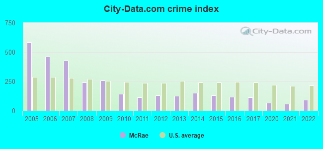
| City-Data.com crime index | 257.2 | 144.1 | 116.2 | 132.6 | 128.3 | 151.6 | 131.2 | 119.8 | 112.7 | 68.3 | 57.9 | 93.6 |
The City-Data.com crime index weighs serious crimes and violent crimes more heavily. Higher means more crime, U.S. average is 246.1. It adjusts for the number of visitors and daily workers commuting into cities.
Crime rate in McRae detailed stats: murders, rapes, robberies, assaults, burglaries, thefts, arson
Full-time law enforcement employees in 2021, including police officers: 11 (10 officers - 10 male; 0 female).
| Officers per 1,000 residents here: | 1.21 |
| Georgia average: | 2.45 |
 Recent articles from our blog. Our writers, many of them Ph.D. graduates or candidates, create easy-to-read articles on a wide variety of topics.


Latest news from McRae, GA collected exclusively by city-data.com from local newspapers, TV, and radio stations
Ancestries: English (29.3%), American (15.9%), Irish (2.6%), German (2.1%), European (1.6%), African (1.2%).
Current Local Time: EST time zone
Elevation: 258 feet
Land area: 3.37 square miles.
Population density: 1,774 people per square mile (low).
11 residents are foreign born
| This city: | 0.2% |
| Georgia: | 100.0% |
Median real estate property taxes paid for housing units with mortgages in 2022: $1,313 (1.0%)
Median real estate property taxes paid for housing units with no mortgage in 2022: $1,215 (0.9%)
Nearest city with pop. 50,000+: Macon, GA  (68.7 miles , pop. 97,255).
Nearest city with pop. 200,000+: Jacksonville, FL (141.2 miles , pop. 735,617).
Nearest city with pop. 1,000,000+: Philadelphia, PA (698.8 miles , pop. 1,517,550).
Nearest cities:
)Latitude: 32.06 N, Longitude: 82.90 W
Area code: 229
McRae, Georgia accommodation & food services, waste management - Economy and Business Data
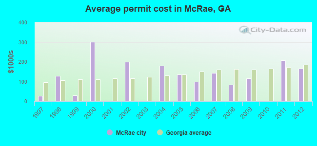
Single-family new house construction building permits:
- 2012: 1 building, cost: $165,000
- 2011: 1 building, cost: $207,600
- 2009: 3 buildings, average cost: $115,500
- 2008: 1 building, cost: $85,000
- 2007: 2 buildings, average cost: $142,000
- 2006: 1 building, cost: $100,000
- 2005: 3 buildings, average cost: $135,000
- 2004: 2 buildings, average cost: $180,000
- 2002: 2 buildings, average cost: $199,300
- 2000: 1 building, cost: $300,000
- 1999: 2 buildings, average cost: $30,000
- 1998: 1 building, cost: $128,000
- 1997: 3 buildings, average cost: $26,700

| Here: | 5.3% |
| Georgia: | 2.9% |
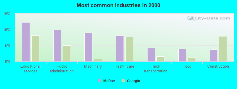
- Educational services (12.3%)
- Public administration (10.0%)
- Machinery (9.0%)
- Health care (8.2%)
- Truck transportation (4.2%)
- Food (4.0%)
- Construction (3.7%)
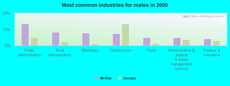
- Public administration (13.5%)
- Truck transportation (8.4%)
- Machinery (7.8%)
- Construction (7.4%)
- Food (4.9%)
- Administrative & support & waste management services (4.9%)
- Finance & insurance (4.2%)
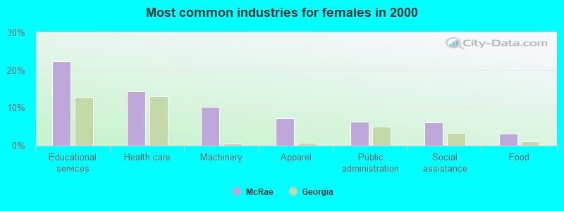
- Educational services (22.3%)
- Health care (14.3%)
- Machinery (10.3%)
- Apparel (7.4%)
- Public administration (6.4%)
- Social assistance (6.2%)
- Food (3.1%)
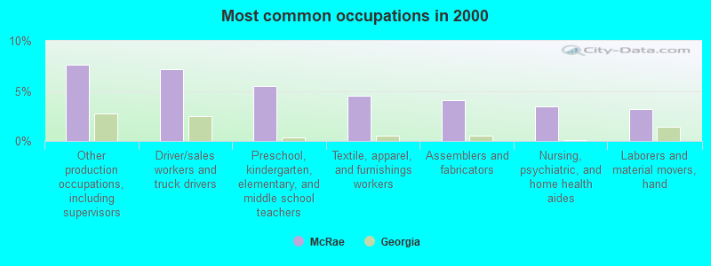
- Other production occupations, including supervisors (7.6%)
- Driver/sales workers and truck drivers (7.2%)
- Preschool, kindergarten, elementary, and middle school teachers (5.5%)
- Textile, apparel, and furnishings workers (4.5%)
- Assemblers and fabricators (4.0%)
- Nursing, psychiatric, and home health aides (3.5%)
- Laborers and material movers, hand (3.2%)
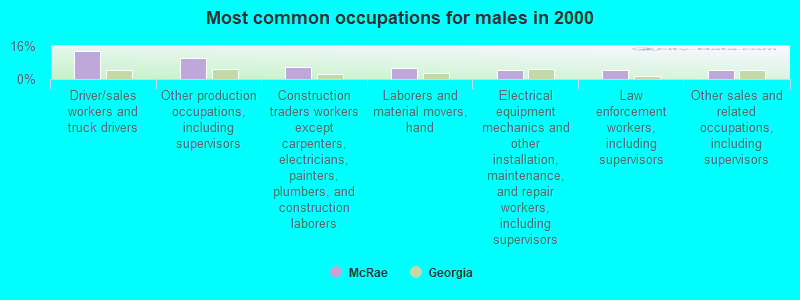
- Driver/sales workers and truck drivers (13.5%)
- Other production occupations, including supervisors (10.3%)
- Construction traders workers except carpenters, electricians, painters, plumbers, and construction laborers (5.7%)
- Laborers and material movers, hand (5.1%)
- Electrical equipment mechanics and other installation, maintenance, and repair workers, including supervisors (4.6%)
- Law enforcement workers, including supervisors (4.4%)
- Other sales and related occupations, including supervisors (4.4%)
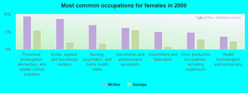
- Preschool, kindergarten, elementary, and middle school teachers (9.5%)
- Textile, apparel, and furnishings workers (8.7%)
- Nursing, psychiatric, and home health aides (7.0%)
- Secretaries and administrative assistants (6.2%)
- Assemblers and fabricators (5.0%)
- Other production occupations, including supervisors (4.8%)
- Health technologists and technicians (3.7%)
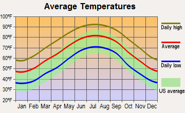
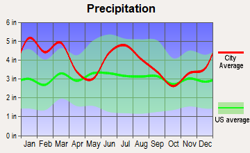
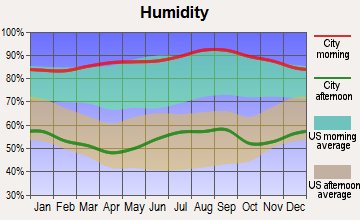
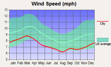
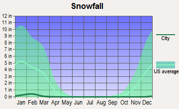
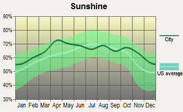
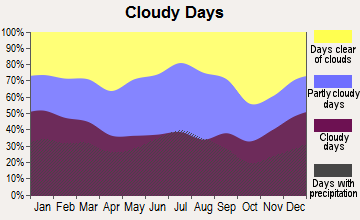
Average climate in McRae, Georgia
Based on data reported by over 4,000 weather stations
Tornado activity:
McRae-area historical tornado activity is near Georgia state average. It is 13% greater than the overall U.S. average.
On 4/8/1957, a category F3 (max. wind speeds 158-206 mph) tornado 15.4 miles away from the McRae city center killed one person and injured 3 people and caused between $5000 and $50,000 in damages.
On 5/11/2008, a category F3 tornado 26.6 miles away from the city center .
Earthquake activity:
McRae-area historical earthquake activity is significantly above Georgia state average. It is 22% smaller than the overall U.S. average.On 8/2/1974 at 08:52:09, a magnitude 4.9 (4.3 MB, 4.9 LG, Class: Light, Intensity: IV - V) earthquake occurred 127.3 miles away from the city center
On 11/22/1974 at 05:25:55, a magnitude 4.7 (4.7 MB) earthquake occurred 170.7 miles away from the city center
On 4/29/2003 at 08:59:39, a magnitude 4.9 (4.4 MB, 4.6 MW, 4.9 LG) earthquake occurred 230.6 miles away from the city center
On 10/24/1997 at 08:35:17, a magnitude 4.9 (4.8 MB, 4.2 MS, 4.9 LG, Depth: 6.2 mi) earthquake occurred 265.8 miles away from the city center
On 8/21/1992 at 16:31:55, a magnitude 4.4 (4.1 MB, 4.1 LG, 4.4 LG, Depth: 6.2 mi) earthquake occurred 175.9 miles away from McRae center
On 2/15/2014 at 03:23:38, a magnitude 4.1 (4.1 MW, Depth: 3.2 mi) earthquake occurred 129.9 miles away from the city center
Magnitude types: regional Lg-wave magnitude (LG), body-wave magnitude (MB), surface-wave magnitude (MS), moment magnitude (MW)
Natural disasters:
The number of natural disasters in Telfair County (9) is smaller than the US average (15).Major Disasters (Presidential) Declared: 5
Emergencies Declared: 3
Causes of natural disasters: Floods: 3, Tornadoes: 3, Hurricanes: 2, Storms: 2, Tropical Storms: 2, Drought: 1, Heavy Rain: 1, Snowfall: 1, Wind: 1, Winter Storm: 1, Other: 1 (Note: some incidents may be assigned to more than one category).

Hospitals and medical centers in McRae:
Colleges/universities with over 2000 students nearest to McRae:
- South Georgia State College (about 40 miles; Douglas, GA; Full-time enrollment: 2,507)
- East Georgia State College (about 51 miles; Swainsboro, GA; FT enrollment: 2,345)
- Abraham Baldwin Agricultural College (about 55 miles; Tifton, GA; FT enrollment: 2,564)
- Central Georgia Technical College (about 56 miles; Warner Robins, GA; FT enrollment: 6,829)
- Fort Valley State University (about 67 miles; Fort Valley, GA; FT enrollment: 3,200)
- Mercer University (about 69 miles; Macon, GA; FT enrollment: 6,297)
- Georgia Southern University (about 70 miles; Statesboro, GA; FT enrollment: 18,824)
Public high school in McRae:
- TELFAIR COUNTY HIGH SCHOOL (Students: 403, Location: 458 S THIRD AVE, Grades: 9-12)
Public elementary/middle schools in McRae:
- TELFAIR COUNTY ELEMENTARY (Students: 963, Location: 532 E OAK ST, Grades: PK-5)
- TELFAIR COUNTY MIDDLE SCHOOL (Students: 385, Location: 3 W HIGHWAY 280, Grades: 6-8)
Points of interest:
Notable locations in McRae: Telfair County Fire Department (A), McRae - Helena Fire Department (B), Telfair County Library (C), Telfair County Jail (D), Telfair County Courthouse (E), Telfair Community Center (F), McRae Senior Center (G), McRae City Hall (H). Display/hide their locations on the map
Churches in McRae include: McRae United Methodist Church (A), McRae Presbyterian Church (B), First Baptist Church (C), Corinth Christian Methodist Episcopal Church (D), Central Valley Baptist Church (E), Central Baptist Church (F). Display/hide their locations on the map
Cemetery: Oak Grove Cemetery (1). Display/hide its location on the map
Reservoir: Smith Lake (A). Display/hide its location on the map
Birthplace of: Herman Talmadge - Politician, Kim Batten - Athletics competitor.
| This city: | 2.4 people |
| Georgia: | 2.6 people |
| This city: | 62.4% |
| Whole state: | 68.5% |
| This city: | 6.8% |
| Whole state: | 5.9% |
Likely homosexual households (counted as self-reported same-sex unmarried-partner households)
- Lesbian couples: 0.4% of all households
- Gay men: 0.3% of all households
People in group quarters in McRae in 2010:
- 1,744 people in federal prisons
- 131 people in nursing facilities/skilled-nursing facilities
- 27 people in local jails and other municipal confinement facilities
8 people in local jails and other confinement facilities (including police lockups) in 2000
For population 15 years and over in McRae:
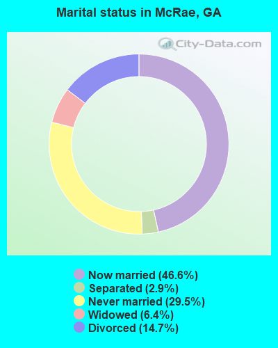
- Never married: 29.5%
- Now married: 46.6%
- Separated: 2.9%
- Widowed: 6.4%
- Divorced: 14.7%
For population 25 years and over in McRae:
- High school or higher: 78.8%
- Bachelor's degree or higher: 20.6%
- Graduate or professional degree: 13.3%
- Unemployed: 8.3%
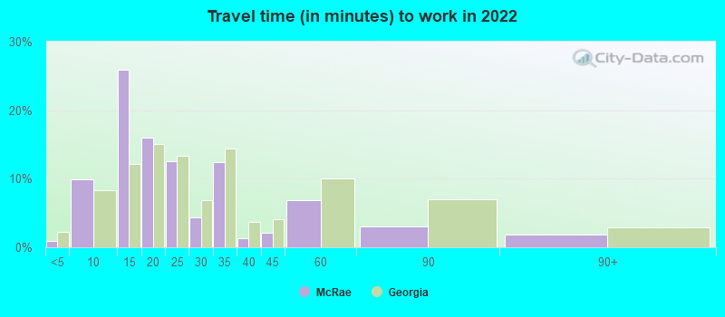
- Mean travel time to work (commute): 21.0 minutes
| Here: | 14.8 |
| Georgia average: | 12.2 |

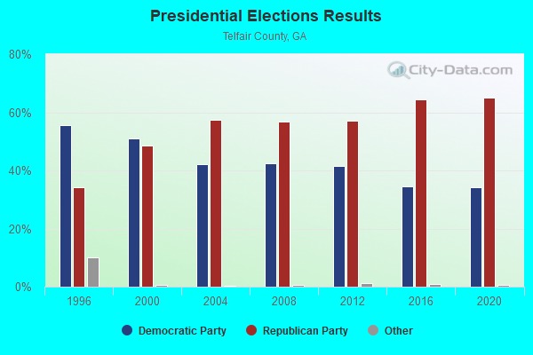
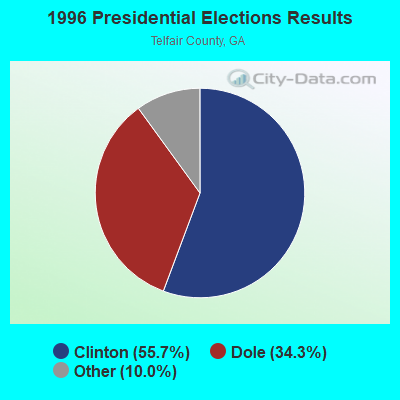
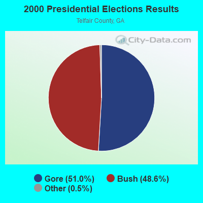

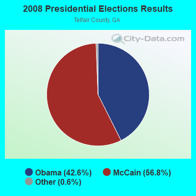
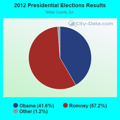


Graphs represent county-level data. Detailed 2008 Election Results
Religion statistics for McRae, GA (based on Telfair County data)
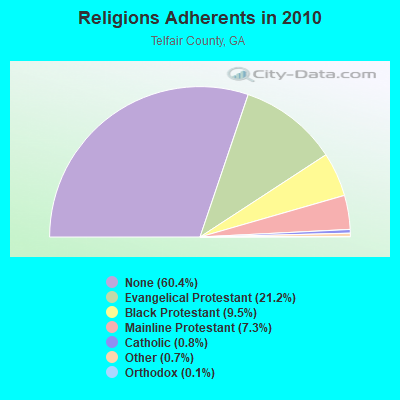
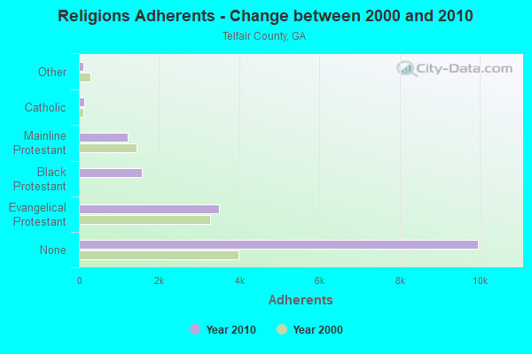
| Religion | Adherents | Congregations |
|---|---|---|
| Evangelical Protestant | 3,493 | 25 |
| Black Protestant | 1,568 | 13 |
| Mainline Protestant | 1,209 | 18 |
| Catholic | 127 | 1 |
| Other | 118 | 3 |
| Orthodox | 20 | 1 |
| None | 9,965 | - |
Food Environment Statistics:
| Telfair County: | 2.99 / 10,000 pop. |
| Georgia: | 1.91 / 10,000 pop. |
| Telfair County: | 0.75 / 10,000 pop. |
| Georgia: | 0.86 / 10,000 pop. |
| Here: | 4.49 / 10,000 pop. |
| Georgia: | 5.12 / 10,000 pop. |
| This county: | 4.49 / 10,000 pop. |
| Georgia: | 7.41 / 10,000 pop. |
| Here: | 11.3% |
| Georgia: | 10.4% |
| This county: | 29.5% |
| Georgia: | 27.8% |
| Telfair County: | 16.3% |
| Georgia: | 14.6% |
| Local government employment and payroll (March 2012) | |||||
| Function | Full-time employees | Monthly full-time payroll | Average yearly full-time wage | Part-time employees | Monthly part-time payroll |
|---|---|---|---|---|---|
| Police Protection - Officers | 8 | $34,835 | $52,253 | 0 | $0 |
| Solid Waste Management | 7 | $13,755 | $23,580 | 1 | $1,054 |
| Firefighters | 4 | $13,100 | $39,300 | 0 | $0 |
| Water Supply | 3 | $7,285 | $29,140 | 1 | $2,299 |
| Other Government Administration | 2 | $9,447 | $56,682 | 7 | $3,162 |
| Financial Administration | 2 | $6,142 | $36,852 | 0 | $0 |
| Streets and Highways | 2 | $7,750 | $46,500 | 0 | $0 |
| Sewerage | 1 | $4,747 | $56,964 | 0 | $0 |
| Police - Other | 1 | $2,994 | $35,928 | 0 | $0 |
| Other and Unallocable | 0 | $0 | 1 | $399 | |
| Totals for Government | 30 | $100,055 | $40,022 | 10 | $6,914 |
McRae government finances - Expenditure in 2017 (per resident):
- Current Operations - Police Protection: $875,000 ($146.52)
Water Utilities: $582,000 ($97.45)
Regular Highways: $543,000 ($90.92)
Solid Waste Management: $485,000 ($81.21)
Sewerage: $455,000 ($76.19)
Local Fire Protection: $345,000 ($57.77)
Central Staff Services: $235,000 ($39.35)
Financial Administration: $96,000 ($16.08)
General - Other: $42,000 ($7.03)
Judicial and Legal Services: $41,000 ($6.87)
Parks and Recreation: $41,000 ($6.87)
General Public Buildings: $25,000 ($4.19)
Health - Other: $6,000 ($1.00)
Libraries: $6,000 ($1.00)
Protective Inspection and Regulation - Other: $6,000 ($1.00)
- Other Capital Outlay - Solid Waste Management: $101,000 ($16.91)
Regular Highways: $23,000 ($3.85)
- Total Salaries and Wages: $1,229,000 ($205.79)
- Water Utilities - Interest on Debt: $118,000 ($19.76)
McRae government finances - Revenue in 2002 (per resident):
- Charges - Sewerage: $675,000 ($113.03)
Solid Waste Management: $421,000 ($70.50)
- Federal Intergovernmental - Other: $14,000 ($2.34)
General Local Government Support: $14,000 ($2.34)
- Local Intergovernmental - General Local Government Support: $268,000 ($44.88)
Other: $223,000 ($37.34)
- Miscellaneous - Fines and Forfeits: $262,000 ($43.87)
General Revenue - Other: $78,000 ($13.06)
Interest Earnings: $16,000 ($2.68)
Royalties: $15,000 ($2.51)
- Revenue - Water Utilities: $666,000 ($111.52)
- State Intergovernmental - Housing and Community Development: $2,000 ($0.33)
- Tax - Property: $1,009,000 ($168.96)
Public Utilities Sales: $303,000 ($50.74)
Occupation and Business License - Other: $128,000 ($21.43)
Alcoholic Beverage Sales: $85,000 ($14.23)
Alcoholic Beverage License: $24,000 ($4.02)
Other Selective Sales: $13,000 ($2.18)
Other License: $7,000 ($1.17)
McRae government finances - Debt in 2017 (per resident):
- Long Term Debt - Beginning Outstanding - Unspecified Public Purpose: $2,697,000 ($451.61)
Outstanding Unspecified Public Purpose: $2,490,000 ($416.95)
Retired Unspecified Public Purpose: $207,000 ($34.66)
McRae government finances - Cash and Securities in 2017 (per resident):
- Other Funds - Cash and Securities: $2,724,000 ($456.13)
Businesses in McRae, GA
- McDonald's: 1
- Subway: 1
Strongest AM radio stations in McRae:
- WYIS (1410 AM; 1 kW; MCRAE, GA; Owner: CINECOM BROASCASTING SYSTEM, INC.)
- WMAC (940 AM; 50 kW; MACON, GA; Owner: CUMULUS LICENSING CORP.)
- WUFF (710 AM; daytime; 2 kW; EASTMAN, GA; Owner: FARNELL O'QUINN)
- WVOP (970 AM; 5 kW; VIDALIA, GA; Owner: VIDALIA COMMUNICATIONS CORPORATION)
- WOKV (690 AM; 50 kW; JACKSONVILLE, FL; Owner: COX RADIO, INC.)
- WDMG (860 AM; 5 kW; DOUGLAS, GA; Owner: RTG RADIO, LLC)
- WFVR (910 AM; 50 kW; VALDOSTA, GA; Owner: RAMA COMMUNICATIONS, INC.)
- WUFE (1260 AM; daytime; 5 kW; BAXLEY, GA; Owner: SOUTH GEORGIA BROADCASTERS, INC.)
- WGST (640 AM; 50 kW; ATLANTA, GA; Owner: CITICASTERS LICENSES, L.P.)
- WNNG (1350 AM; 15 kW; WARNER ROBINS, GA; Owner: CHASE BROADCASTING, INC.)
- WMLT (1330 AM; 5 kW; DUBLIN, GA; Owner: STATE BROADCASTING CORPORATION)
- WSB (750 AM; 50 kW; ATLANTA, GA; Owner: CXR HOLDINGS, INC.)
- WCNN (680 AM; 50 kW; NORTH ATLANTA, GA; Owner: DICKEY BROADCASTING COMPANY)
Strongest FM radio stations in McRae:
- WYSC (102.7 FM; MCRAE, GA; Owner: CINECOM BROASCASTING SYSTEM, INC.)
- WOKA-FM (106.7 FM; DOUGLAS, GA; Owner: COFFEE COUNTY BROADCASTERS, INC.)
- WBYZ (94.5 FM; BAXLEY, GA; Owner: SOUTH GEORGIA BROADCASTERS, INC.)
- WDCO-FM (89.7 FM; COCHRAN, GA; Owner: GEORGIA PUBLIC TELECOMMUNICATIONS COMMISSION)
- WMCG (104.9 FM; MILAN, GA; Owner: TEL-DODGE BROADCASTING CO.)
- WQIL (101.3 FM; CHAUNCEY, GA; Owner: GSW, INC.)
- WUFF-FM (97.5 FM; EASTMAN, GA; Owner: FARNELL O'QUINN)
- WGPH (91.5 FM; VIDALIA, GA; Owner: AUGUSTA RADIO FELLOWSHIP INSTITUTE,)
- WMOC (88.7 FM; LUMBER CITY, GA; Owner: FULL GOSPEL CHURCH OF GOD WRITTEN)
- WYUM (101.7 FM; MOUNT VERNON, GA; Owner: VIDALIA COMMUNICATIONS CORPORATION)
- WVOH-FM (93.5 FM; HAZLEHURST, GA; Owner: JEFF DAVIS BROADCASTERS, INC.)
TV broadcast stations around McRae:
- WDCO-TV (Channel 29; COCHRAN, GA; Owner: GEORGIA PUBLIC TELECOMMUNICATIONS COMMISSION)
- WPHJ-CA (Channel 46; VIDALIA, GA; Owner: BARINOWSKI INVESTMENT COMPANY, L.P.)
- National Bridge Inventory (NBI) Statistics
- 5Number of bridges
- 66ft / 20.1mTotal length
- $3,924,000Total costs
- 23,660Total average daily traffic
- 729Total average daily truck traffic
- 35,490Total future (year 2031) average daily traffic
FCC Registered Antenna Towers:
67 (See the full list of FCC Registered Antenna Towers in McRae)FCC Registered Broadcast Land Mobile Towers:
18 (See the full list of FCC Registered Broadcast Land Mobile Towers in McRae, GA)FCC Registered Microwave Towers:
3- Mc Rae, Route 1, State Route 149 Conn (Lat: 32.024278 Lon: -82.895528), Type: Tower, Structure height: 141.7 m, Overall height: 148.1 m, Call Sign: WQOY988,
Assigned Frequencies: 928.468 MHz, 952.468 MHz, Grant Date: 03/08/2012, Expiration Date: 09/04/2012, Cancellation Date: 11/10/2012, Certifier: Larry F Butts, Registrant: Fish & Richardson P.C., 1425 K Street, N.W., 11th Floor, Washington, DC 20005, Phone: (202) 626-7761, Fax: (202) 783-2331, Email:
- MCRAE, Route 1, State Route 149 Conn (Lat: 32.024278 Lon: -82.895528), Type: Gtower, Structure height: 141.7 m, Overall height: 148.1 m, Call Sign: WQZB451,
Assigned Frequencies: 11305.0 MHz, 11345.0 MHz, 11465.0 MHz, 11505.0 MHz, 11305.0 MHz, 11345.0 MHz, 11465.0 MHz, 11505.0 MHz, 11305.0 MHz, 11345.0 MHz... (+22 more), Grant Date: 03/28/2017, Expiration Date: 03/28/2027, Certifier: Larry F Butts, Registrant: Southern Company Services, 600 N. 18th St / Bin 5n-5409, Birmingham, AL 35203, Phone: (205) 257-7600, Fax: (205) 257-2134, Email:
- STATION, Intersect Of Us Hwy 441 & 341 (Lat: 32.063222 Lon: -82.882083), Overall height: 61.9 m, Call Sign: WEF915,
Assigned Frequencies: 2146.00 MHz, Grant Date: 03/08/2000, Expiration Date: 05/16/2010, Cancellation Date: 05/02/2003, Registrant: Mcdermott, Will & Emery, 600 13th Street, Nw, Washington, DC 20005-3096, Phone: (202) 756-8283, Fax: (202) 756-8087, Email:
FCC Registered Maritime Coast & Aviation Ground Towers:
1- Telfair-Wheeler Airport (Lat: 32.095028 Lon: -82.882222), Type: Pipe, Structure height: 3.6 m, Overall height: 4.5 m, Call Sign: WRJH431,
Assigned Frequencies: 120.000 MHz, Grant Date: 08/31/2020, Expiration Date: 08/31/2030, Certifier: Jimmy Ray, Registrant: Dbt Transportation Services, LLC, 2655 Crescent Drive; Suite A1, Lafayette, CO 80026, Phone: (612) 805-5558, Email:
FCC Registered Amateur Radio Licenses:
2- Call Sign: KN4AAT, Licensee ID: L02073919, Grant Date: 01/06/2017, Expiration Date: 01/06/2027, Cancellation Date: 10/12/2018, Certifier: Billy W Walker Jr, Registrant: Billy W Walker Jr, 36 Humingbird Lane, Mcrae, GA 31055
- Call Sign: N4BWW, Previous Call Sign: KN4AAT, Licensee ID: L02073919, Grant Date: 10/12/2018, Expiration Date: 10/12/2028, Certifier: Billy W Walker Jr, Registrant: Billy W Walker Jr, 36 Humingbird Lane, Mcrae, GA 31055
2002 - 2018 National Fire Incident Reporting System (NFIRS) incidents
- Fire incident types reported to NFIRS in McRae, GA
- 33142.7%Structure Fires
- 32541.9%Outside Fires
- 10213.1%Mobile Property/Vehicle Fires
- 182.3%Other
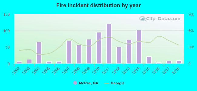 Based on the data from the years 2002 - 2018 the average number of fires per year is 46. The highest number of reported fires - 121 took place in 2011, and the least - 3 in 2016. The data has an increasing trend.
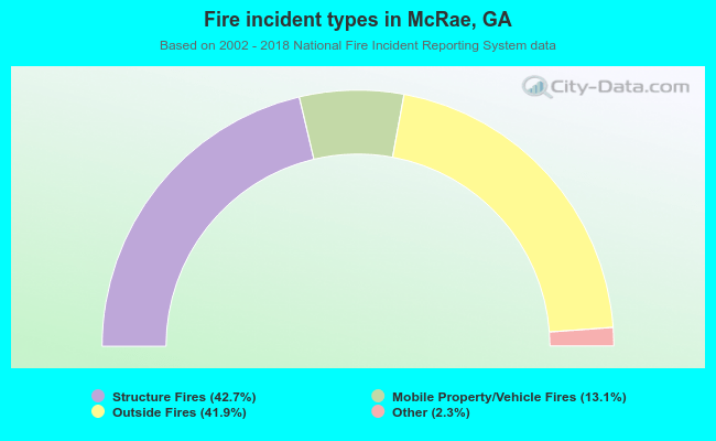 When looking into fire subcategories, the most reports belonged to: Structure Fires (42.7%), and Outside Fires (41.9%).
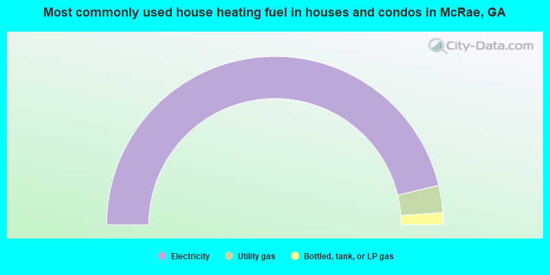
- 92.5%Electricity
- 5.2%Utility gas
- 2.3%Bottled, tank, or LP gas
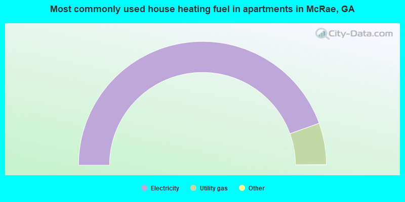
- 89.1%Electricity
- 10.9%Utility gas
McRae compared to Georgia state average:
- Median household income below state average.
- Median house value significantly below state average.
- Unemployed percentage below state average.
- Black race population percentage significantly above state average.
- Hispanic race population percentage below state average.
- Foreign-born population percentage significantly below state average.
- Length of stay since moving in significantly above state average.
- House age above state average.
- Institutionalized population percentage significantly above state average.
McRae on our top lists:
- #23 on the list of "Top 101 cities with largest percentage of males in occupations: law enforcement workers including supervisors (population 5,000+)"
- #26 on the list of "Top 101 cities with largest percentage of males in occupations: food preparation and serving related occupations (population 5,000+)"
- #49 on the list of "Top 101 cities with the highest number of assaults per 100,000 residents, excludes tourist destinations and others with a lot of outsiders visiting based on city industries data (population 5,000+)"
- #67 on the list of "Top 100 cities with the largest percentage of males (pop. 5,000+)"
- #70 on the list of "Top 101 cities with the lowest percentage of workers working at home, population 5,000+"
- #71 on the list of "Top 101 cities with largest percentage of females in occupations: education, training, and library occupations (population 5,000+)"
- #71 on the list of "Top 101 cities with the largest city-data.com crime index per police officer (population 5,000+)"
- #71 on the list of "Top 101 cities with the largest percentage population increase from 2000 (population 5,000+)"
- #76 on the list of "Top 101 cities with largest percentage of females in occupations: law enforcement workers including supervisors (population 5,000+)"
- #90 on the list of "Top 101 cities with largest percentage of males in industries: accommodation and food services (population 5,000+)"
- #93 on the list of "Top 101 cities with the most people below the poverty level, excluding cities with 15% or more of residents in college and with the median age below 28 (population 5,000+)"
- #79 (31055) on the list of "Top 101 zip codes with the largest percentage of English first ancestries"
- #83 on the list of "Top 101 counties with the smallest number of children under 18 without health insurance coverage in 2000"