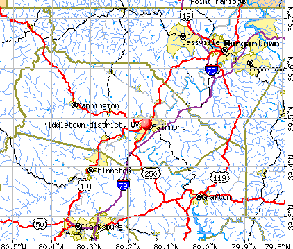
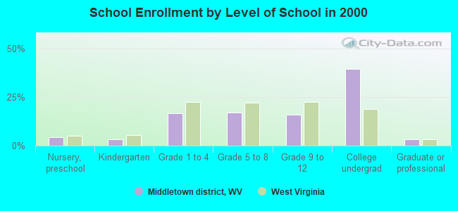
Middletown district, West Virginia
Submit your own pictures of this city and show them to the world
- OSM Map
- General Map
- Google Map
- MSN Map
| Males: 8,387 | |
| Females: 9,619 |
| Median resident age: | 38.9 years |
| West Virginia median age: | 38.9 years |
Zip code: 26554
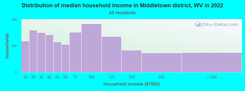
| Middletown district: | $52,658 |
| WV: | $54,329 |
Estimated per capita income in 2022: $31,972 (it was $16,129 in 2000)
Middletown district income, earnings, and wages data
Estimated median house or condo value in 2022: $157,015 (it was $60,400 in 2000)
| Middletown district: | $157,015 |
| WV: | $155,100 |
Mean prices in 2022: all housing units: $200,248; detached houses: $209,631; townhouses or other attached units: $182,439; in 2-unit structures: $119,249; in 3-to-4-unit structures: $230,203; mobile homes: $70,526
Middletown district, WV residents, houses, and apartments details
Detailed information about poverty and poor residents in Middletown district, WV
Compare current foreclosures near Middletown district, WV:
| Photo | Address | Area | Beds / Baths | Price | Details |
|---|---|---|---|---|---|

|
#1
Walnut St
Grafton, WV 26354
|
1,956 sq. feet
|
1 baths 3 beds |
$62,500
|
show details |

|
#2
Lambert Ave
Fairmont, WV 26554
|
1,406 sq. feet
|
1 baths 2 beds |
$44,500
|
show details |

|
#3
W Main St
Grafton, WV 26354
|
960 sq. feet
|
1 baths 3 beds |
$51,900
|
show details |

|
#4
Wadestown Road
Hundred, WV 26575
|
- sq. feet
|
2 baths 3 beds |
show details | |

|
#5
Eastwood Dr
Fairmont, WV 26554
|
1,220 sq. feet
|
1 baths 2 beds |
show details | |

|
#6
Anderson Hollow Rd
Mannington, WV 26582
|
1,832 sq. feet
|
1 baths 2 beds |
show details | |

|
#7
Herman Ave
Morgantown, WV 26505
|
1,248 sq. feet
|
2 baths 4 beds |
show details | |

|
#8
Briercliff Rd
Bridgeport, WV 26330
|
1,362 sq. feet
|
1 baths 3 beds |
show details | |

|
#9
Festus Ridge Rd
Worthington, WV 26591
|
960 sq. feet
|
1 baths 2 beds |
show details | |

|
#10
Pleasant Valley Rd
Fairmont, WV 26554
|
1,162 sq. feet
|
1 baths 2 beds |
show details |
| Photo | Address | Area | Beds / Baths | Price | Details |
|---|---|---|---|---|---|

|
#11
High St
Shinnston, WV 26431
|
1,165 sq. feet
|
1 baths 3 beds |
show details | |

|
#12
Marcus Dr
Morgantown, WV 26501
|
1,120 sq. feet
|
1 baths 2 beds |
show details | |

|
#13
1/2 School St
Barrackville, WV 26559
|
1 sq. feet
|
3 baths 2 beds |
show details | |

|
#14
Edgeway Dr
Fairmont, WV 26554
|
1,858 sq. feet
|
1 baths 2 beds |
show details | |

|
#15
Bolyard Rd
Grafton, WV 26354
|
- sq. feet
|
- baths - beds |
$27,900
|
show details |

|
#16
A-B Richmond St
Morgantown, WV 26501
|
1,433 sq. feet
|
2 baths 7 beds |
show details | |

|
#17
Goshen Rd
Morgantown, WV 26508
|
1,920 sq. feet
|
1 baths 3 beds |
show details | |

|
#18
Friend Dr
Morgantown, WV 26508
|
1,840 sq. feet
|
2 baths 3 beds |
show details | |

|
#19
3rd Street
Carolina, WV 26563
|
- sq. feet
|
2 baths 2 beds |
show details | |

|
#20
Marcus Dr
Morgantown, WV 26501
|
1,080 sq. feet
|
1 baths 3 beds |
show details |
| Photo | Address | Area | Beds / Baths | Price | Details |
|---|---|---|---|---|---|

|
#21
College Park
Fairmont, WV 26554
|
1,466 sq. feet
|
1 baths 4 beds |
show details | |

|
#22
Wisconsin Ave
Morgantown, WV 26501
|
984 sq. feet
|
1 baths 3 beds |
show details | |

|
#23
Laurel St
Morgantown, WV 26505
|
908 sq. feet
|
1 baths 2 beds |
show details | |

|
#24
W 1st St
Morgantown, WV 26501
|
828 sq. feet
|
1 baths 2 beds |
show details | |

|
#25
Peaceful Rd
Morgantown, WV 26501
|
1,440 sq. feet
|
2 baths 3 beds |
show details | |

|
#26
Maple St
Worthington, WV 26591
|
- sq. feet
|
2 baths 3 beds |
show details | |

|
#27
Drexel Pl
Fairmont, WV 26554
|
1,650 sq. feet
|
2 baths 3 beds |
show details | |

|
#28
Spruce St
Fairmont, WV 26554
|
1,818 sq. feet
|
1 baths 3 beds |
show details | |

|
#29
Cadet Ct
Morgantown, WV 26508
|
2,147 sq. feet
|
2 baths 2 beds |
show details | |

|
#30
Hampton Rd
Fairmont, WV 26554
|
1,344 sq. feet
|
1 baths 5 beds |
show details |
| Photo | Address | Area | Beds / Baths | Price | Details |
|---|---|---|---|---|---|

|
#31
Tyrone Rd
Morgantown, WV 26508
|
1,368 sq. feet
|
3 baths 4 beds |
show details | |

|
#32
Tygart St
Fairmont, WV 26554
|
864 sq. feet
|
1 baths 3 beds |
show details | |

|
#33
Bellview Ave
Fairmont, WV 26554
|
1,940 sq. feet
|
2 baths 3 beds |
show details | |

|
#34
Brytes Way
Morgantown, WV 26508
|
1,188 sq. feet
|
2 baths 3 beds |
show details | |

|
#35
Maryland Ave
Fairmont, WV 26554
|
1,456 sq. feet
|
2 baths 4 beds |
show details | |

|
#36
Clifton Rd
Fairmont, WV 26554
|
1,000 sq. feet
|
2 baths 3 beds |
show details | |

|
#37
Russell Ct
Fairmont, WV 26554
|
960 sq. feet
|
1 baths 2 beds |
show details | |

|
#38
Cherry Ln
Morgantown, WV 26505
|
1,744 sq. feet
|
2 baths 4 beds |
show details | |

|
#39
Bethel Rd
Morgantown, WV 26501
|
1,000 sq. feet
|
1 baths 3 beds |
show details | |

|
#40
Summers School Rd
Morgantown, WV 26508
|
1,620 sq. feet
|
1 baths 3 beds |
show details |
| Photo | Address | Area | Beds / Baths | Price | Details |
|---|---|---|---|---|---|

|
#41
Turnstone Dr
Morgantown, WV 26505
|
- sq. feet
|
- baths - beds |
show details | |

|
#42
Buckeye Rd
Maidsville, WV 26541
|
- sq. feet
|
- baths - beds |
show details | |

|
#43
Mccartney Ave Apt B
Morgantown, WV 26505
|
- sq. feet
|
- baths - beds |
show details | |

|
#44
W 5th St
Morgantown, WV 26501
|
- sq. feet
|
- baths - beds |
show details | |

|
#45
Broadway St
Flemington, WV 26347
|
- sq. feet
|
- baths - beds |
show details | |

|
#46
Jones Run Rd
Lumberport, WV 26386
|
- sq. feet
|
- baths - beds |
show details | |

|
#47
Duvall Ln
Morgantown, WV 26501
|
- sq. feet
|
- baths - beds |
show details | |

|
#48
Legend Dr
Bridgeport, WV 26330
|
- sq. feet
|
- baths - beds |
show details | |

|
#49
Whites Carver Rd
Grafton, WV 26354
|
- sq. feet
|
- baths - beds |
show details | |

|
Check over 1 million property listings on Foreclosure.com!
|
browse all offers | |||

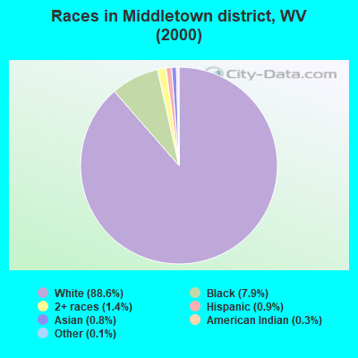
- 15,88588.6%White alone
- 1,4087.9%Black alone
- 2581.4%Two or more races
- 1590.9%Hispanic
- 1520.8%Asian alone
- 480.3%American Indian alone
- 200.1%Other race alone
- 40.02%Native Hawaiian and Other
Pacific Islander alone
Races in Middletown district detailed stats: ancestries, foreign born residents, place of birth
 Recent articles from our blog. Our writers, many of them Ph.D. graduates or candidates, create easy-to-read articles on a wide variety of topics.
Current Local Time: EST time zone
Land area: 21.0 square miles.
Population density: 859 people per square mile (low).

| Middletown district: | 0.6% ($392) |
| West Virginia: | 0.6% ($378) |
Nearest city with pop. 50,000+: Pittsburgh, PA  (66.7 miles , pop. 334,563).
Nearest city with pop. 1,000,000+: Philadelphia, PA (268.7 miles , pop. 1,517,550).
Nearest cities:
), ), ), Latitude: 39.49 N, Longitude: 80.15 W
Area code commonly used in this area: 304

| Here: | 4.0% |
| West Virginia: | 4.0% |
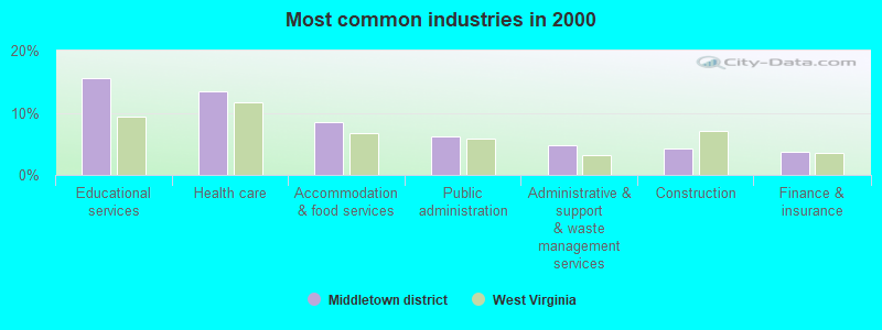
- Educational services (15.7%)
- Health care (13.5%)
- Accommodation & food services (8.5%)
- Public administration (6.2%)
- Administrative & support & waste management services (4.7%)
- Construction (4.3%)
- Finance & insurance (3.8%)
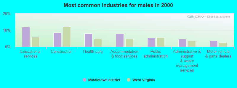
- Educational services (11.8%)
- Construction (8.6%)
- Health care (8.0%)
- Accommodation & food services (7.8%)
- Public administration (5.3%)
- Administrative & support & waste management services (4.5%)
- Motor vehicle & parts dealers (3.6%)
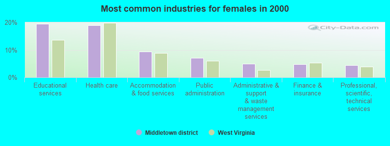
- Educational services (19.4%)
- Health care (19.0%)
- Accommodation & food services (9.3%)
- Public administration (7.0%)
- Administrative & support & waste management services (4.9%)
- Finance & insurance (4.8%)
- Professional, scientific, technical services (4.4%)
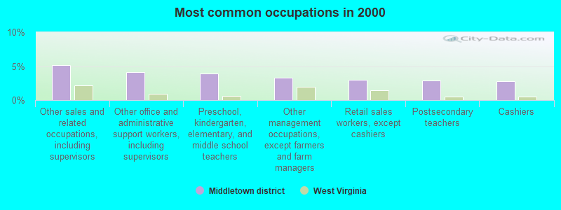
- Other sales and related occupations, including supervisors (5.2%)
- Other office and administrative support workers, including supervisors (4.1%)
- Preschool, kindergarten, elementary, and middle school teachers (3.9%)
- Other management occupations, except farmers and farm managers (3.3%)
- Retail sales workers, except cashiers (3.0%)
- Postsecondary teachers (2.9%)
- Cashiers (2.8%)
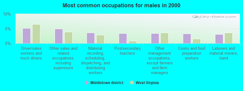
- Driver/sales workers and truck drivers (5.2%)
- Other sales and related occupations, including supervisors (4.9%)
- Material recording, scheduling, dispatching, and distributing workers (3.6%)
- Postsecondary teachers (3.4%)
- Other management occupations, except farmers and farm managers (3.4%)
- Cooks and food preparation workers (3.3%)
- Laborers and material movers, hand (3.1%)
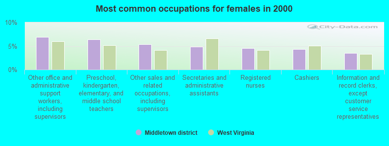
- Other office and administrative support workers, including supervisors (6.9%)
- Preschool, kindergarten, elementary, and middle school teachers (6.4%)
- Other sales and related occupations, including supervisors (5.4%)
- Secretaries and administrative assistants (4.8%)
- Registered nurses (4.5%)
- Cashiers (4.3%)
- Information and record clerks, except customer service representatives (3.5%)
Average climate in Middletown district, West Virginia
Based on data reported by over 4,000 weather stations


(lower is better)
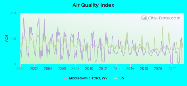
Air Quality Index (AQI) level in 2022 was 40.2. This is significantly better than average.
| City: | 40.2 |
| U.S.: | 72.6 |
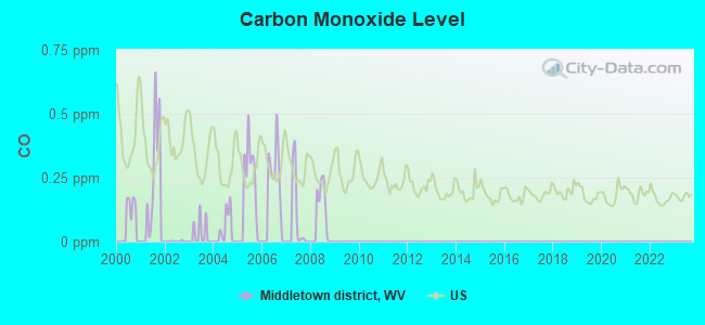
Carbon Monoxide (CO) [ppm] level in 2008 was 0.148. This is significantly better than average. Closest monitor was 23.1 miles away from the city center.
| City: | 0.148 |
| U.S.: | 0.251 |
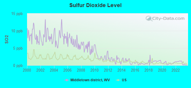
Sulfur Dioxide (SO2) [ppb] level in 2022 was 1.14. This is better than average. Closest monitor was 1.4 miles away from the city center.
| City: | 1.14 |
| U.S.: | 1.51 |
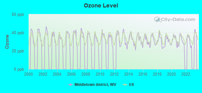
Ozone [ppb] level in 2022 was 31.4. This is about average. Closest monitor was 16.8 miles away from the city center.
| City: | 31.4 |
| U.S.: | 33.3 |
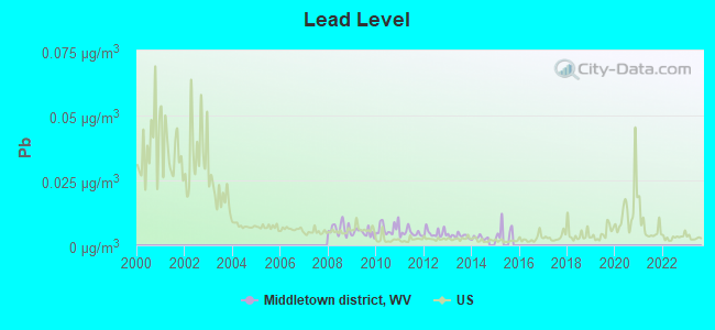
Lead (Pb) [µg/m3] level in 2014 was 0.00291. This is significantly better than average. Closest monitor was 1.4 miles away from the city center.
| City: | 0.00291 |
| U.S.: | 0.00931 |
Tornado activity:
Middletown district-area historical tornado activity is slightly above West Virginia state average. It is 60% smaller than the overall U.S. average.
On 6/3/1980, a category F3 (max. wind speeds 158-206 mph) tornado 13.9 miles away from the Middletown district city center injured 19 people and caused between $500,000 and $5,000,000 in damages.
On 10/1/1986, a category F3 tornado 35.9 miles away from the city center injured one person and caused between $50,000 and $500,000 in damages.
Earthquake activity:
Middletown district-area historical earthquake activity is significantly above West Virginia state average. It is 40% smaller than the overall U.S. average.On 8/23/2011 at 17:51:04, a magnitude 5.8 (5.8 MW, Depth: 3.7 mi, Class: Moderate, Intensity: VI - VII) earthquake occurred 161.9 miles away from the city center
On 9/25/1998 at 19:52:52, a magnitude 5.2 (4.8 MB, 4.3 MS, 5.2 LG, 4.5 MW, Depth: 3.1 mi) earthquake occurred 139.2 miles away from Middletown district center
On 1/31/1986 at 16:46:43, a magnitude 5.0 (5.0 MB) earthquake occurred 155.6 miles away from the city center
On 7/27/1980 at 18:52:21, a magnitude 5.2 (5.1 MB, 4.7 MS, 5.0 UK, 5.2 UK) earthquake occurred 222.5 miles away from the city center
On 8/9/2020 at 12:07:37, a magnitude 5.1 (5.1 MW, Depth: 4.7 mi) earthquake occurred 214.5 miles away from Middletown district center
On 8/25/2011 at 05:07:52, a magnitude 4.5 (4.5 ML, Depth: 4.2 mi, Class: Light, Intensity: IV - V) earthquake occurred 158.9 miles away from the city center
Magnitude types: regional Lg-wave magnitude (LG), body-wave magnitude (MB), local magnitude (ML), surface-wave magnitude (MS), moment magnitude (MW)
Natural disasters:
The number of natural disasters in Marion County (18) is near the US average (15).Major Disasters (Presidential) Declared: 13
Emergencies Declared: 4
Causes of natural disasters: Floods: 10, Storms: 10, Landslides: 5, Mudslides: 3, Tornadoes: 3, Winter Storms: 3, Hurricanes: 2, Blizzard: 1, Snowfall: 1, Snowstorm: 1, Other: 1 (Note: some incidents may be assigned to more than one category).
Hospitals and medical centers near Middletown district:
- FAIRMONT GENERAL HOSPITAL Acute Care Hospitals (about 1 miles away; FAIRMONT, WV)
- FAIRMONT GROUP HOME (Hospital, about 2 miles away; FAIRMONT, WV)
- PIERPONT CENTER AT FAIRMONT CAMPUS (Nursing Home, about 2 miles away; FAIRMONT, WV)
- ARBORS AT FAIRMONT (Nursing Home, about 2 miles away; FAIRMONT, WV)
- FAIRMONT GENERAL HOSPITAL HOME HEALTH (Home Health Center, about 2 miles away; FAIRMONT, WV)
- GRAFTON TAYLOR CO HEALTH DEPARTMENT HOME HEALTH (Home Health Center, about 12 miles away; GRAFTON, WV)
- GRAFTON CITY HOSPITAL (Nursing Home, about 13 miles away; GRAFTON, WV)
Colleges/universities with over 2000 students nearest to Middletown district:
- Fairmont State University (about 1 miles; Fairmont, WV; Full-time enrollment: 3,714)
- West Virginia University (about 15 miles; Morgantown, WV; FT enrollment: 27,429)
- Waynesburg University (about 29 miles; Waynesburg, PA; FT enrollment: 2,080)
- California University of Pennsylvania (about 43 miles; California, PA; FT enrollment: 7,773)
- West Liberty University (about 53 miles; West Liberty, WV; FT enrollment: 2,728)
- Westmoreland County Community College (about 61 miles; Youngwood, PA; FT enrollment: 4,669)
- Pittsburgh Technical Institute (about 65 miles; Oakdale, PA; FT enrollment: 2,805)
Points of interest:
Notable locations in Middletown district: Fairmont Field Club (A), Fairmont Field Club Golf Course (B), Marion County Rescue Squad Incorporated Station 20 (C), Jan - Care Ambulance Service Incorporated Fairmont (D), HealthSouth Mountainview Regional Rehabilitation Hospital (E), Marion County Public Library (F), J Harper Meredith Building (G), Fire Station Number 3 (H), Fairmont Fire Department Station 1 Central (I), Fairmont Fire Department Station 4 Bellview (J), North Hall (K), Morrow Hall (L), West Virginia Division of Forestry Marion County Field Office (M), Barrackville Volunteer Fire Department (N). Display/hide their locations on the map
Churches in Middletown district include: Katy Church (A), Union Mission of Fairmont (B), Trinity Methodist Church (C), The Baptist Temple (D), The Apostics of God Church (E), Saint Peters Roman Catholic Church (F), Saint Josephs Roman Catholic Church (G), Mount Zion Baptist Church (H), Morningstar Baptist Church (I). Display/hide their locations on the map
Cemeteries: Freeland Cemetery (1), Holy Cross Cemetery (2), Evergreen Cemetery (3), Maple Grove Cemetery (4), Memorial Presbyterian Church Cemetery (5), Fairmont City Cemetery (6), Snoderly Cemetery (7). Display/hide their locations on the map
Reservoir: Barrackville Number 41 Lake (A). Display/hide its location on the map
Streams, rivers, and creeks: Moody Run (A), Little Mill Fall Run (B), Johnson Run (C), Goose Run (D), Finchs Run (E), Fairmont Run (F), Davy Run (G), Coal Run (H), Buffalo Creek (I). Display/hide their locations on the map
Parks in Middletown district include: Windmill Park (1), Twelfth Street Municipal Swimming Pool (2), Fairmont East-West Stadium (3). Display/hide their locations on the map
| This city: | 2.2 people |
| West Virginia: | 2.4 people |
| This city: | 55.3% |
| Whole state: | 65.8% |
| This city: | 7.5% |
| Whole state: | 6.6% |
Likely homosexual households (counted as self-reported same-sex unmarried-partner households)
- Lesbian couples: 0.3% of all households
- Gay men: 0.4% of all households
| This city: | 21.2% |
| Whole state: | 17.9% |
| This city: | 9.8% |
| Whole state: | 7.6% |
People in group quarters in Middletown district in 2010:
- 789 people in college/university student housing
- 108 people in nursing facilities/skilled-nursing facilities
- 79 people in other noninstitutional facilities
- 67 people in emergency and transitional shelters (with sleeping facilities) for people experiencing homelessness
- 38 people in group homes intended for adults
- 4 people in workers' group living quarters and job corps centers
People in group quarters in Middletown district in 2000:
- 392 people in college dormitories (includes college quarters off campus)
- 333 people in nursing homes
- 112 people in local jails and other confinement facilities (including police lockups)
- 75 people in other noninstitutional group quarters
- 26 people in orthopedic wards and institutions for the physically handicapped
- 20 people in hospitals/wards and hospices for chronically ill
- 20 people in other hospitals or wards for chronically ill
- 20 people in mental (psychiatric) hospitals or wards
- 9 people in homes or halfway houses for drug/alcohol abuse
For population 15 years and over in Middletown district:
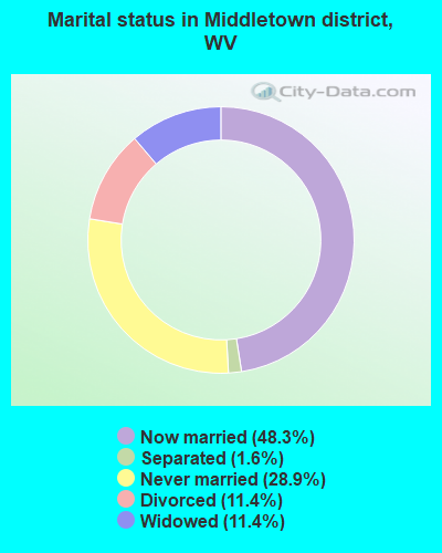
- Never married: 28.9%
- Now married: 48.3%
- Separated: 1.6%
- Widowed: 11.4%
- Divorced: 11.4%
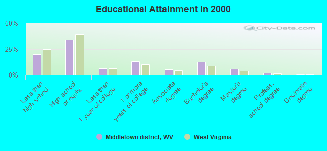
For population 25 years and over in Middletown district:
- High school or higher: 79.9%
- Bachelor's degree or higher: 21.3%
- Graduate or professional degree: 8.7%
- Unemployed: 9.4%
- Mean travel time to work (commute): 19.2 minutes
| Here: | 12.5 |
| West Virginia average: | 12.7 |
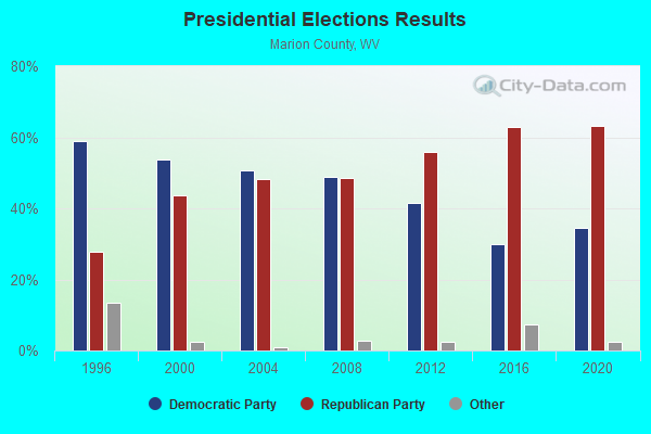
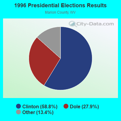
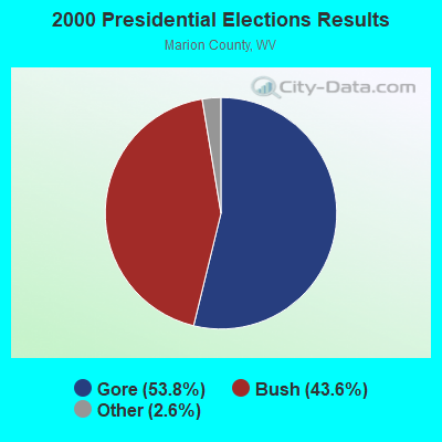
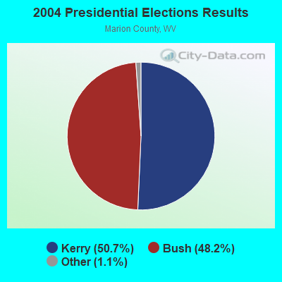
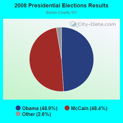
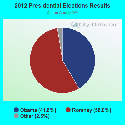
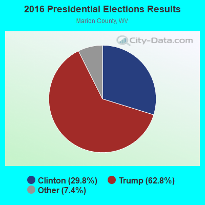
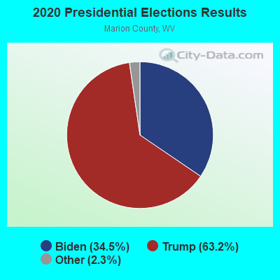
Graphs represent county-level data. Detailed 2008 Election Results
Religion statistics for Middletown district, WV (based on Marion County data)
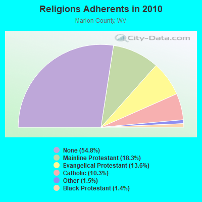
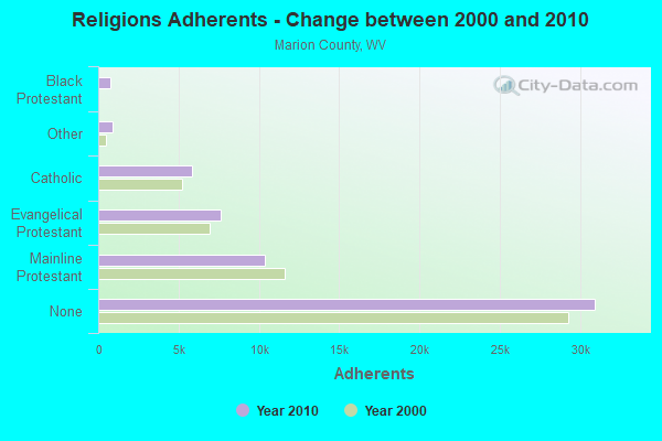
| Religion | Adherents | Congregations |
|---|---|---|
| Mainline Protestant | 10,344 | 73 |
| Evangelical Protestant | 7,649 | 55 |
| Catholic | 5,819 | 7 |
| Other | 873 | 3 |
| Black Protestant | 768 | 2 |
| Orthodox | 25 | 1 |
| None | 30,940 | - |
Food Environment Statistics:
| Marion County: | 1.77 / 10,000 pop. |
| West Virginia: | 2.41 / 10,000 pop. |
| Here: | 1.06 / 10,000 pop. |
| State: | 1.09 / 10,000 pop. |
| This county: | 5.82 / 10,000 pop. |
| West Virginia: | 5.38 / 10,000 pop. |
| Here: | 5.12 / 10,000 pop. |
| West Virginia: | 6.22 / 10,000 pop. |
| Here: | 10.0% |
| State: | 12.2% |
| This county: | 31.1% |
| State: | 31.1% |
| Marion County: | 11.6% |
| State: | 13.1% |
Strongest AM radio stations in Middletown district:
- WMMN (920 AM; 5 kW; FAIRMONT, WV; Owner: FANTASIA BROADCASTING, INC.)
- WTCS (1490 AM; 1 kW; FAIRMONT, WV; Owner: FAIRMONT BROADCASTING COMPANY)
- WAJR (1440 AM; 5 kW; MORGANTOWN, WV; Owner: WEST VIRGINIA RADIO CORPORATION)
- WWVA (1170 AM; 53 kW; WHEELING, WV; Owner: CAPSTAR TX LIMITED PARTNERSHIP)
- WCLG (1300 AM; 2 kW; MORGANTOWN, WV; Owner: BOWERS BROADCASTING CORP.)
- KDKA (1020 AM; 50 kW; PITTSBURGH, PA; Owner: INFINITY BROADCASTING OPERATIONS, INC.)
- WTVN (610 AM; 50 kW; COLUMBUS, OH; Owner: CITICASTERS LICENSES, L.P.)
- WTBZ (1260 AM; 0 kW; GRAFTON, WV; Owner: APPALACHIAN RADIO LLC)
- WBUC (1460 AM; 5 kW; BUCKHANNON, WV; Owner: CAT RADIO, INC.)
- WOBG (1400 AM; 1 kW; CLARKSBURG, WV; Owner: BURBACH OF DE, LLC)
- WPDX (750 AM; daytime; 1 kW; CLARKSBURG, WV; Owner: TSCHUDY BROADCASTING CORP.)
- WXKX (1340 AM; 1 kW; CLARKSBURG, WV; Owner: BURBACH OF DE, LLC)
- WWCS (540 AM; 5 kW; CANONSBURG, PA; Owner: BIRACH BROADCASTING CORPORATION)
Strongest FM radio stations in Middletown district:
- WGYE (102.7 FM; MANNINGTON, WV; Owner: BURBACH OF DE, LLC)
- WBVQ (93.1 FM; BARRACKVILLE, WV; Owner: CAT RADIO, INC.)
- WRLF (94.3 FM; FAIRMONT, WV; Owner: FAIRMONT BROADCASTING COMPANY)
- WKKW (97.9 FM; FAIRMONT, WV; Owner: DESCENDANTS TRUST, LAUREN M.KELLEY, TRUSTEE)
- WVPM (90.9 FM; MORGANTOWN, WV; Owner: WEST VIRGINIA EDUCATIONAL BROADCASTING AUTHORITY)
- WGIE (92.7 FM; CLARKSBURG, WV; Owner: BURBACH OF DE, LLC)
- WZWA (90.1 FM; CLARKSBURG, WV; Owner: MARANATHA BROADCASTING, INC.)
- WVAQ (101.9 FM; MORGANTOWN, WV; Owner: WEST VIRGINIA RADIO CORPORATION)
- WKJL (88.1 FM; CLARKSBURG, WV; Owner: HE'S ALIVE, INC.)
- WDCI (104.1 FM; BRIDGEPORT, WV; Owner: WDCI RADIO, INC)
- WAJR-FM (103.3 FM; SALEM, WV; Owner: WEST VIRGINIA RADIO CORPORATION OF SALEM)
- W220BZ (91.9 FM; CLARKSBURG, WV; Owner: EDUCATIONAL MEDIA FOUNDATION)
- WDKL (95.9 FM; GRAFTON, WV; Owner: EDUCATIONAL MEDIA FOUNDATION)
- WOBG-FM (105.7 FM; SALEM, WV; Owner: BURBACH OF DE, LLC)
- WRIJ (106.9 FM; MASONTOWN, PA; Owner: HE'S ALIVE INC.)
- WPDX-FM (104.9 FM; CLARKSBURG, WV; Owner: TSCHUDY BROADCASTING CORP.)
- WWLW (106.5 FM; CLARKSBURG, WV; Owner: WEST VIRGINIA RADIO CORPORATION OF CLARKSBURG)
- WOGG (94.9 FM; OLIVER, PA; Owner: KEYMARKET LICENSES, LLC)
- WDBS (97.1 FM; SUTTON, WV; Owner: SUMMIT MEDIA BROADCASTING, L.L.C.)
- WZST (100.9 FM; WESTOVER, WV; Owner: TSCHUDY BROADCASTING CORP.)
TV broadcast stations around Middletown district:
- WVFX (Channel 46; CLARKSBURG, WV; Owner: DAVIS TELEVISION CLARKSBURG, LLC)
- WBOY-TV (Channel 12; CLARKSBURG, WV; Owner: WEST VIRGINIA MEDIA HOLDINGS, LLC)
- WNPB-TV (Channel 24; MORGANTOWN, WV; Owner: WEST VIRGINIA EDUCATIONAL BROADCASTING AUTHORITY)
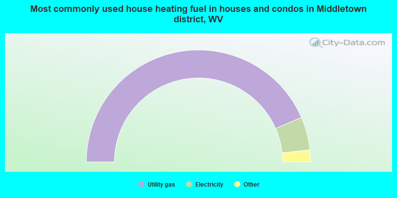
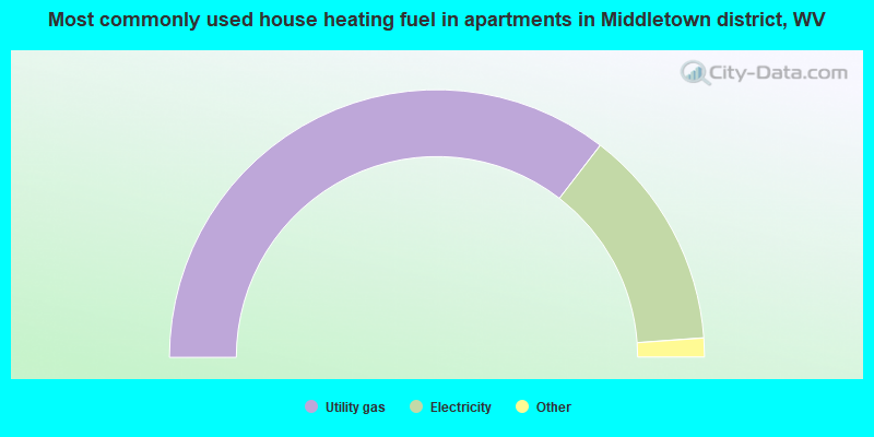
- 87.1%Utility gas
- 9.6%Electricity
- 1.4%Bottled, tank, or LP gas
- 1.2%Wood
- 0.5%Fuel oil, kerosene, etc.
- 0.1%Other fuel
- 70.9%Utility gas
- 26.8%Electricity
- 0.9%Bottled, tank, or LP gas
- 0.6%Wood
- 0.5%Other fuel
- 0.4%Fuel oil, kerosene, etc.
Middletown district compared to West Virginia state average:
- Black race population percentage above state average.
- Hispanic race population percentage below state average.
- Foreign-born population percentage significantly below state average.
- Length of stay since moving in significantly above state average.
- Number of rooms per house significantly below state average.
- House age significantly below state average.
- Number of college students above state average.
Middletown district on our top lists:
- #20 on the list of "Top 101 cities with largest percentage of males in occupations: extraction workers (population 5,000+)"
- #35 on the list of "Top 101 cities with largest percentage of males in occupations: postsecondary teachers (population 5,000+)"
- #50 on the list of "Top 101 cities with largest percentage of males in industries: alcoholic beverages merchant wholesalers (population 5,000+)"
- #51 on the list of "Top 101 cities with largest percentage of females in industries: recyclable material merchant wholesalers (population 5,000+)"
- #53 on the list of "Top 101 cities with largest percentage of males in occupations: other protective service workers including supervisors (population 5,000+)"
- #54 on the list of "Top 101 cities with largest percentage of males in occupations: entertainers and performers, sports, and related workers (population 5,000+)"
- #55 on the list of "Top 101 cities with largest percentage of females in occupations: postsecondary teachers (population 5,000+)"
- #62 on the list of "Top 101 cities with largest percentage of males in occupations: other food preparation and serving workers including supervisors (population 5,000+)"
- #67 on the list of "Top 101 cities with largest percentage of males in industries: health care (population 5,000+)"
- #72 on the list of "Top 101 cities with largest percentage of females in industries: farm supplies merchant wholesalers (population 5,000+)"
- #81 on the list of "Top 101 cities with largest percentage of males in industries: health and personal care, except drug, stores (population 5,000+)"
- #92 on the list of "Top 101 cities with the largest percentage of people in orthopedic wards and institutions for the physically handicapped (population 1,000+)"
- #29 on the list of "Top 101 counties with the lowest ground withdrawal of fresh water for public supply (pop. 50,000+)"
- #69 on the list of "Top 101 counties with the highest number of deaths per 1000 residents 2007-2013 (pop. 50,000+)"
- #85 on the list of "Top 101 counties with the largest decrease in the number of deaths per 1000 residents 2000-2006 to 2007-2013 (pop. 50,000+)"
- #96 on the list of "Top 101 counties with highest percentage of residents voting for 3rd party candidates in the 2012 Presidential Election (pop. 50,000+)"