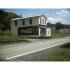
Monongah, West Virginia
Submit your own pictures of this town and show them to the world
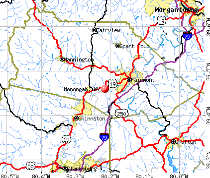
- OSM Map
- General Map
- Google Map
- MSN Map
Population change since 2000: +8.2%
 |
| Males: 493 | |
| Females: 523 |
| Median resident age: | 43.9 years |
| West Virginia median age: | 42.9 years |
Zip codes: 26554.
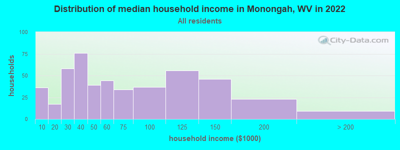
| Monongah: | $54,399 |
| WV: | $54,329 |
Estimated per capita income in 2022: $30,616 (it was $14,079 in 2000)
Monongah town income, earnings, and wages data
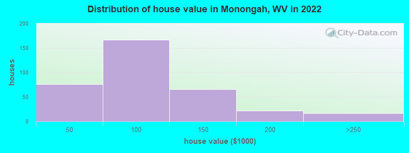
Estimated median house or condo value in 2022: $92,230 (it was $42,100 in 2000)
| Monongah: | $92,230 |
| WV: | $155,100 |
Mean prices in 2022: all housing units: $92,179; detached houses: $98,534; mobile homes: $15,133
Median gross rent in 2022: $850.
(11.0% for White Non-Hispanic residents, 80.0% for Black residents, 100.0% for Hispanic or Latino residents, 100.0% for other race residents, 17.5% for two or more races residents)
Detailed information about poverty and poor residents in Monongah, WV
Compare current foreclosures near Monongah, WV:
| Photo | Address | Area | Beds / Baths | Price | Details |
|---|---|---|---|---|---|

|
#1
Walnut St
Grafton, WV 26354
|
1,956 sq. feet
|
1 baths 3 beds |
$62,500
|
show details |

|
#2
Lambert Ave
Fairmont, WV 26554
|
1,406 sq. feet
|
1 baths 2 beds |
$44,500
|
show details |

|
#3
W Main St
Grafton, WV 26354
|
960 sq. feet
|
1 baths 3 beds |
$51,900
|
show details |

|
#4
George Washington Hwy
Bridgeport, WV 26330
|
2,392 sq. feet
|
1 baths 4 beds |
show details | |

|
#5
Wadestown Road
Hundred, WV 26575
|
- sq. feet
|
2 baths 3 beds |
show details | |

|
#6
Eastwood Dr
Fairmont, WV 26554
|
1,220 sq. feet
|
1 baths 2 beds |
show details | |

|
#7
Ogden Avenue Ext
Fairmont, WV 26554
|
1,432 sq. feet
|
2 baths 3 beds |
show details | |

|
#8
Bolyard Rd
Grafton, WV 26354
|
- sq. feet
|
- baths - beds |
$27,900
|
show details |

|
#9
Anderson Hollow Rd
Mannington, WV 26582
|
1,832 sq. feet
|
1 baths 2 beds |
show details | |

|
#10
High St
Shinnston, WV 26431
|
1,165 sq. feet
|
1 baths 3 beds |
show details |
| Photo | Address | Area | Beds / Baths | Price | Details |
|---|---|---|---|---|---|

|
#11
Pleasant Valley Rd
Fairmont, WV 26554
|
1,162 sq. feet
|
1 baths 2 beds |
show details | |

|
#12
1/2 School St
Barrackville, WV 26559
|
1 sq. feet
|
3 baths 2 beds |
show details | |

|
#13
Briercliff Rd
Bridgeport, WV 26330
|
1,362 sq. feet
|
1 baths 3 beds |
show details | |

|
#14
Goshen Rd
Morgantown, WV 26508
|
1,920 sq. feet
|
1 baths 3 beds |
show details | |

|
#15
Lang Ave
Clarksburg, WV 26301
|
956 sq. feet
|
1 baths 4 beds |
show details | |

|
#16
Bellview Ave
Fairmont, WV 26554
|
1,940 sq. feet
|
2 baths 3 beds |
show details | |

|
#17
Maryland Ave
Fairmont, WV 26554
|
1,456 sq. feet
|
2 baths 4 beds |
show details | |

|
#18
Brytes Way
Morgantown, WV 26508
|
1,188 sq. feet
|
2 baths 3 beds |
show details | |

|
#19
Clifton Rd
Fairmont, WV 26554
|
1,000 sq. feet
|
2 baths 3 beds |
show details | |

|
#20
3rd Street
Carolina, WV 26563
|
- sq. feet
|
2 baths 2 beds |
show details |
| Photo | Address | Area | Beds / Baths | Price | Details |
|---|---|---|---|---|---|

|
#21
Hampton Rd
Fairmont, WV 26554
|
1,344 sq. feet
|
1 baths 5 beds |
show details | |

|
#22
Drexel Pl
Fairmont, WV 26554
|
1,650 sq. feet
|
2 baths 3 beds |
show details | |

|
#23
Tygart St
Fairmont, WV 26554
|
864 sq. feet
|
1 baths 3 beds |
show details | |

|
#24
Tuna St
Clarksburg, WV 26301
|
- sq. feet
|
1 baths 2 beds |
show details | |

|
#25
College Park
Fairmont, WV 26554
|
1,466 sq. feet
|
1 baths 4 beds |
show details | |

|
#26
Russell Ct
Fairmont, WV 26554
|
960 sq. feet
|
1 baths 2 beds |
show details | |

|
#27
Spruce St
Fairmont, WV 26554
|
1,818 sq. feet
|
1 baths 3 beds |
show details | |

|
#28
Jones Run Rd
Lumberport, WV 26386
|
- sq. feet
|
- baths - beds |
show details | |

|
#29
Wickwire Rd
Grafton, WV 26354
|
- sq. feet
|
- baths - beds |
show details | |

|
#30
Howard St Apt 103
Grafton, WV 26354
|
- sq. feet
|
- baths - beds |
show details |
| Photo | Address | Area | Beds / Baths | Price | Details |
|---|---|---|---|---|---|

|
#31
Main Ave, Apt 1
Fairmont, WV 26554
|
- sq. feet
|
- baths - beds |
show details | |

|
#32
Locust Ave Apt 2
Clarksburg, WV 26301
|
- sq. feet
|
- baths - beds |
show details | |

|
#33
Buckhannon Ave
Clarksburg, WV 26301
|
- sq. feet
|
- baths - beds |
show details | |

|
#34
Pratt Ave
Clarksburg, WV 26301
|
- sq. feet
|
- baths - beds |
show details | |

|
#35
Broadway St
Flemington, WV 26347
|
- sq. feet
|
- baths - beds |
show details | |

|
#36
Stonecrest Dr
Grafton, WV 26354
|
- sq. feet
|
- baths - beds |
show details | |

|
#37
Beryl Ln
Morgantown, WV 26508
|
- sq. feet
|
- baths - beds |
show details | |

|
#38
Wilsonburg Rd
Clarksburg, WV 26301
|
- sq. feet
|
- baths - beds |
show details | |

|
#39
Buddys Hollow Rd
Wallace, WV 26448
|
- sq. feet
|
- baths - beds |
show details | |

|
#40
S 5th St
Clarksburg, WV 26301
|
- sq. feet
|
- baths - beds |
show details |
| Photo | Address | Area | Beds / Baths | Price | Details |
|---|---|---|---|---|---|

|
#41
Union Camp Rd
Shinnston, WV 26431
|
- sq. feet
|
- baths - beds |
show details | |

|
#42
Legend Dr
Bridgeport, WV 26330
|
- sq. feet
|
- baths - beds |
show details | |

|
#43
Linn Hollow Rd
Shinnston, WV 26431
|
- sq. feet
|
- baths - beds |
show details | |

|
#44
Old Monongah Rd
Fairmont, WV 26554
|
- sq. feet
|
- baths - beds |
show details | |

|
#45
Gaston Ave Apt B
Fairmont, WV 26554
|
- sq. feet
|
- baths - beds |
show details | |

|
#46
Hill View Ter
Enterprise, WV 26568
|
- sq. feet
|
- baths - beds |
show details | |

|
#47
Front St
Fairmont, WV 26554
|
- sq. feet
|
- baths - beds |
show details | |

|
#48
Watercrest Ln
Fairmont, WV 26554
|
- sq. feet
|
- baths - beds |
show details | |

|
#49
Lehman Ave
Fairmont, WV 26554
|
- sq. feet
|
- baths - beds |
show details | |

|
Check over 1 million property listings on Foreclosure.com!
|
browse all offers | |||


- 94290.5%White alone
- 545.2%Two or more races
- 444.2%Black alone
- 10.10%Hispanic
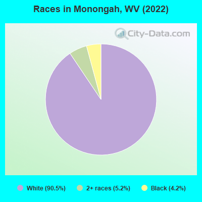
Races in Monongah detailed stats: ancestries, foreign born residents, place of birth
According to our research of West Virginia and other state lists, there were 4 registered sex offenders living in Monongah, West Virginia as of April 29, 2024.
The ratio of all residents to sex offenders in Monongah is 269 to 1.
Type |
2009 |
2011 |
2012 |
2016 |
2017 |
2018 |
|---|---|---|---|---|---|---|
| Murders (per 100,000) | 0 (0.0) | 0 (0.0) | 0 (0.0) | 0 (0.0) | 0 (0.0) | 0 (0.0) |
| Rapes (per 100,000) | 0 (0.0) | 0 (0.0) | 0 (0.0) | 0 (0.0) | 0 (0.0) | 0 (0.0) |
| Robberies (per 100,000) | 0 (0.0) | 0 (0.0) | 0 (0.0) | 0 (0.0) | 0 (0.0) | 0 (0.0) |
| Assaults (per 100,000) | 0 (0.0) | 0 (0.0) | 0 (0.0) | 2 (181.8) | 2 (179.2) | 3 (264.3) |
| Burglaries (per 100,000) | 0 (0.0) | 0 (0.0) | 0 (0.0) | 0 (0.0) | 0 (0.0) | 0 (0.0) |
| Thefts (per 100,000) | 6 (660.8) | 2 (191.4) | 1 (95.2) | 0 (0.0) | 5 (448.0) | 3 (264.3) |
| Auto thefts (per 100,000) | 0 (0.0) | 0 (0.0) | 0 (0.0) | 0 (0.0) | 1 (89.6) | 0 (0.0) |
| Arson (per 100,000) | 0 (0.0) | 0 (0.0) | 0 (0.0) | 0 (0.0) | 0 (0.0) | 0 (0.0) |
| City-Data.com crime index | 26.4 | 7.7 | 3.8 | 36.4 | 60.9 | 63.4 |
The City-Data.com crime index weighs serious crimes and violent crimes more heavily. Higher means more crime, U.S. average is 246.1. It adjusts for the number of visitors and daily workers commuting into cities.
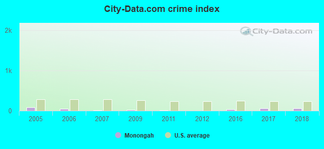
Crime rate in Monongah detailed stats: murders, rapes, robberies, assaults, burglaries, thefts, arson
Full-time law enforcement employees in 2021, including police officers: 1 (1 officers - 1 male; 0 female).
| Officers per 1,000 residents here: | 0.85 |
| West Virginia average: | 1.95 |
 Recent articles from our blog. Our writers, many of them Ph.D. graduates or candidates, create easy-to-read articles on a wide variety of topics.

 | House - 103 mm I-79, Weston, WV? (14 replies) |
| Tech Park seeing big improvements, big plans! (81 replies) |
| West Virginia on "Aerial America" (14 replies) |
| Morgantown, Fairmont, Bridgeport - Compare and contrast please (13 replies) |
| WV celebs (53 replies) |
| Federal #2 Mine *Rental Property* (3 replies) |
Latest news from Monongah, WV collected exclusively by city-data.com from local newspapers, TV, and radio stations
Ancestries: American (15.4%), Italian (14.7%), English (13.2%), Irish (11.2%), German (9.4%), Scotch-Irish (9.4%).
Current Local Time: EST time zone
Incorporated in 1891
Elevation: 900 feet
Land area: 0.47 square miles.
Population density: 2,139 people per square mile (low).
5 residents are foreign born
| This town: | 0.5% |
| West Virginia: | 1.6% |
Median real estate property taxes paid for housing units with mortgages in 2022: $682 (0.7%)
Median real estate property taxes paid for housing units with no mortgage in 2022: $741 (0.9%)
Nearest city with pop. 50,000+: Pittsburgh, PA  (69.1 miles , pop. 334,563).
Nearest city with pop. 1,000,000+: Philadelphia, PA (272.3 miles , pop. 1,517,550).
Nearest cities:
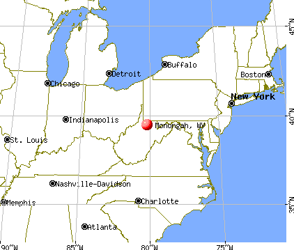
), ), ), ), ), Latitude: 39.46 N, Longitude: 80.22 W
Area code commonly used in this area: 304
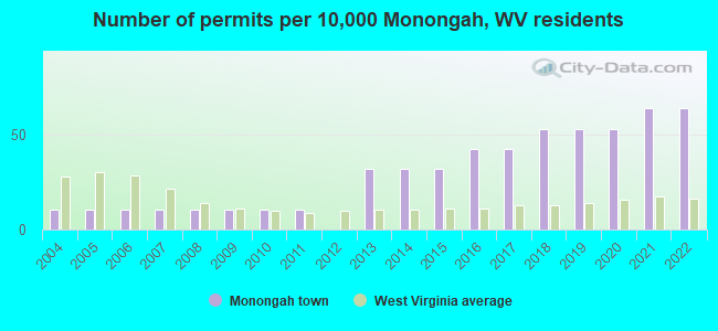
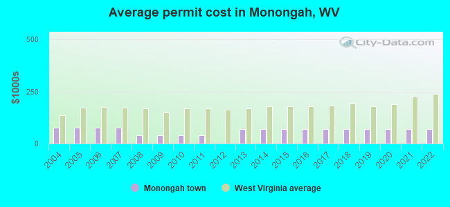
Single-family new house construction building permits:
- 2022: 6 buildings, average cost: $70,700
- 2021: 6 buildings, average cost: $70,700
- 2020: 5 buildings, average cost: $70,700
- 2019: 5 buildings, average cost: $70,700
- 2018: 5 buildings, average cost: $70,700
- 2017: 4 buildings, average cost: $70,700
- 2016: 4 buildings, average cost: $70,700
- 2015: 3 buildings, average cost: $70,700
- 2014: 3 buildings, average cost: $70,700
- 2013: 3 buildings, average cost: $70,700
- 2011: 1 building, cost: $40,000
- 2010: 1 building, cost: $40,000
- 2009: 1 building, cost: $40,000
- 2008: 1 building, cost: $40,000
- 2007: 1 building, cost: $77,000
- 2006: 1 building, cost: $77,000
- 2005: 1 building, cost: $77,000
- 2004: 1 building, cost: $77,000
| Here: | 4.0% |
| West Virginia: | 4.0% |
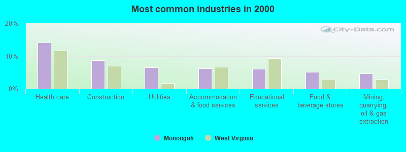
- Health care (14.1%)
- Construction (8.7%)
- Utilities (6.5%)
- Accommodation & food services (6.2%)
- Educational services (6.0%)
- Food & beverage stores (5.2%)
- Mining, quarrying, oil & gas extraction (4.6%)
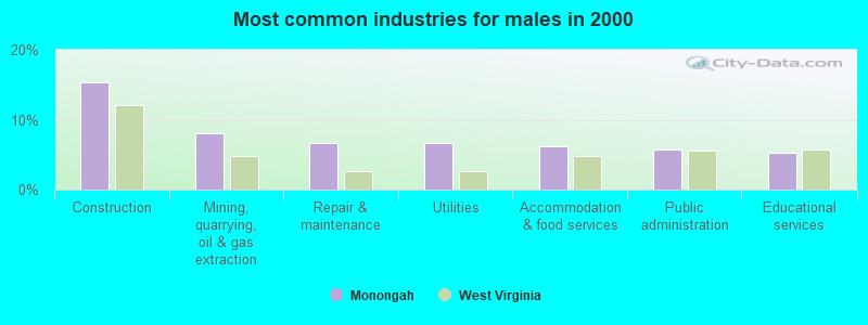
- Construction (15.3%)
- Mining, quarrying, oil & gas extraction (8.1%)
- Repair & maintenance (6.7%)
- Utilities (6.7%)
- Accommodation & food services (6.2%)
- Public administration (5.7%)
- Educational services (5.3%)
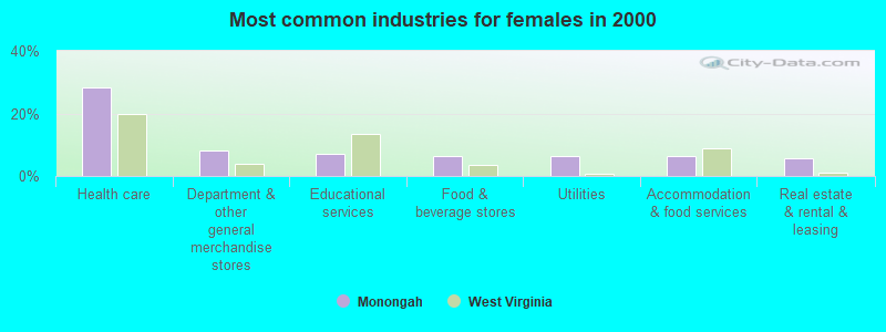
- Health care (28.3%)
- Department & other general merchandise stores (8.2%)
- Educational services (6.9%)
- Food & beverage stores (6.3%)
- Utilities (6.3%)
- Accommodation & food services (6.3%)
- Real estate & rental & leasing (5.7%)
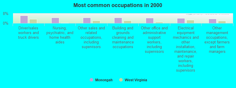
- Driver/sales workers and truck drivers (6.2%)
- Nursing, psychiatric, and home health aides (4.6%)
- Other sales and related occupations, including supervisors (4.6%)
- Building and grounds cleaning and maintenance occupations (4.6%)
- Other office and administrative support workers, including supervisors (4.3%)
- Electrical equipment mechanics and other installation, maintenance, and repair workers, including supervisors (4.1%)
- Other management occupations, except farmers and farm managers (3.5%)
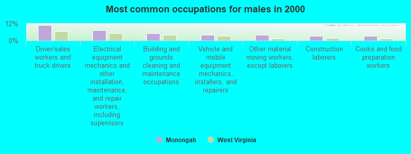
- Driver/sales workers and truck drivers (11.0%)
- Electrical equipment mechanics and other installation, maintenance, and repair workers, including supervisors (7.2%)
- Building and grounds cleaning and maintenance occupations (5.3%)
- Vehicle and mobile equipment mechanics, installers, and repairers (3.8%)
- Other material moving workers, except laborers (3.8%)
- Construction laborers (3.3%)
- Cooks and food preparation workers (3.3%)
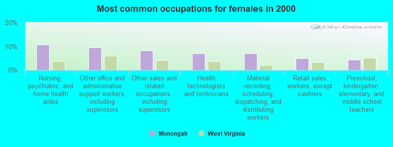
- Nursing, psychiatric, and home health aides (10.7%)
- Other office and administrative support workers, including supervisors (9.4%)
- Other sales and related occupations, including supervisors (8.2%)
- Health technologists and technicians (6.9%)
- Material recording, scheduling, dispatching, and distributing workers (6.9%)
- Retail sales workers, except cashiers (5.0%)
- Preschool, kindergarten, elementary, and middle school teachers (4.4%)
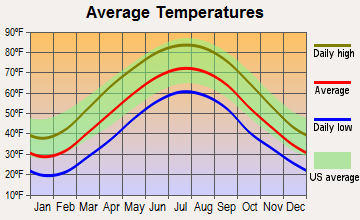
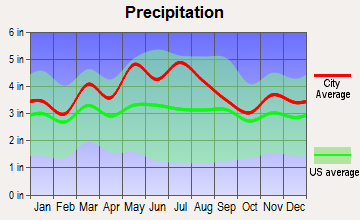
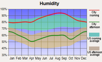
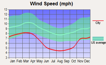
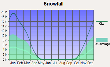
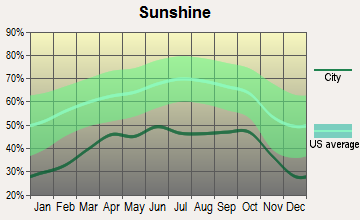
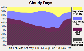
Average climate in Monongah, West Virginia
Based on data reported by over 4,000 weather stations
(lower is better)
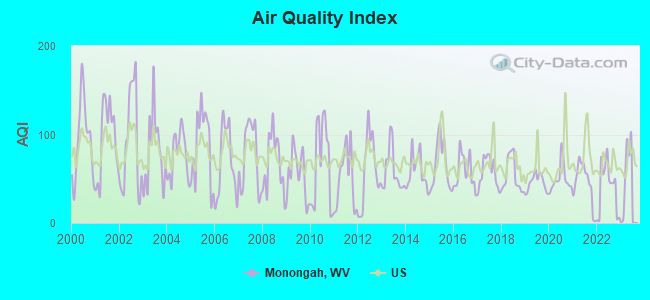
Air Quality Index (AQI) level in 2022 was 40.2. This is significantly better than average.
| City: | 40.2 |
| U.S.: | 72.6 |
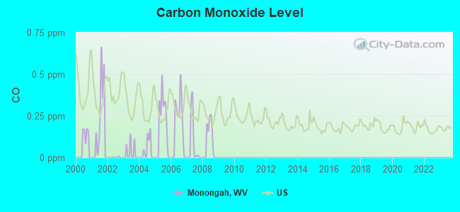
Carbon Monoxide (CO) [ppm] level in 2008 was 0.148. This is significantly better than average. Closest monitor was 24.3 miles away from the city center.
| City: | 0.148 |
| U.S.: | 0.251 |
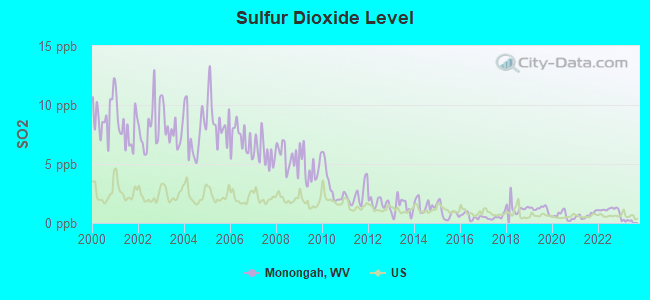
Sulfur Dioxide (SO2) [ppb] level in 2022 was 1.14. This is better than average. Closest monitor was 5.1 miles away from the city center.
| City: | 1.14 |
| U.S.: | 1.51 |
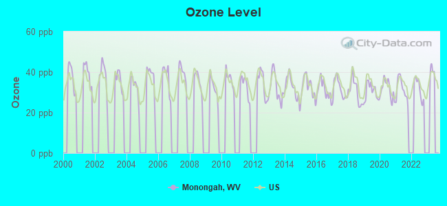
Ozone [ppb] level in 2022 was 31.8. This is about average. Closest monitor was 20.5 miles away from the city center.
| City: | 31.8 |
| U.S.: | 33.3 |
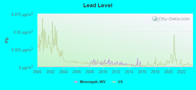
Lead (Pb) [µg/m3] level in 2014 was 0.00291. This is significantly better than average. Closest monitor was 5.1 miles away from the city center.
| City: | 0.00291 |
| U.S.: | 0.00931 |
Tornado activity:
Monongah-area historical tornado activity is slightly above West Virginia state average. It is 62% smaller than the overall U.S. average.
On 6/3/1980, a category F3 (max. wind speeds 158-206 mph) tornado 17.5 miles away from the Monongah town center injured 19 people and caused between $500,000 and $5,000,000 in damages.
On 10/1/1986, a category F3 tornado 32.1 miles away from the town center injured one person and caused between $50,000 and $500,000 in damages.
Earthquake activity:
Monongah-area historical earthquake activity is significantly above West Virginia state average. It is 39% smaller than the overall U.S. average.On 8/23/2011 at 17:51:04, a magnitude 5.8 (5.8 MW, Depth: 3.7 mi, Class: Moderate, Intensity: VI - VII) earthquake occurred 163.2 miles away from the city center
On 9/25/1998 at 19:52:52, a magnitude 5.2 (4.8 MB, 4.3 MS, 5.2 LG, 4.5 MW, Depth: 3.1 mi) earthquake occurred 140.8 miles away from Monongah center
On 1/31/1986 at 16:46:43, a magnitude 5.0 (5.0 MB) earthquake occurred 156.3 miles away from Monongah center
On 7/27/1980 at 18:52:21, a magnitude 5.2 (5.1 MB, 4.7 MS, 5.0 UK, 5.2 UK) earthquake occurred 218.7 miles away from Monongah center
On 8/9/2020 at 12:07:37, a magnitude 5.1 (5.1 MW, Depth: 4.7 mi) earthquake occurred 211.9 miles away from Monongah center
On 8/25/2011 at 05:07:52, a magnitude 4.5 (4.5 ML, Depth: 4.2 mi, Class: Light, Intensity: IV - V) earthquake occurred 160.2 miles away from Monongah center
Magnitude types: regional Lg-wave magnitude (LG), body-wave magnitude (MB), local magnitude (ML), surface-wave magnitude (MS), moment magnitude (MW)
Natural disasters:
The number of natural disasters in Marion County (18) is near the US average (15).Major Disasters (Presidential) Declared: 13
Emergencies Declared: 4
Causes of natural disasters: Floods: 10, Storms: 10, Landslides: 5, Mudslides: 3, Tornadoes: 3, Winter Storms: 3, Hurricanes: 2, Blizzard: 1, Snowfall: 1, Snowstorm: 1, Other: 1 (Note: some incidents may be assigned to more than one category).

Hospitals and medical centers near Monongah:
- PIERPONT CENTER AT FAIRMONT CAMPUS (Nursing Home, about 3 miles away; FAIRMONT, WV)
- ARBORS AT FAIRMONT (Nursing Home, about 3 miles away; FAIRMONT, WV)
- FAIRMONT GROUP HOME (Hospital, about 3 miles away; FAIRMONT, WV)
- FAIRMONT GENERAL HOSPITAL Acute Care Hospitals (about 4 miles away; FAIRMONT, WV)
- FAIRMONT GENERAL HOSPITAL HOME HEALTH (Home Health Center, about 6 miles away; FAIRMONT, WV)
- MEADOWVIEW MANOR HEALTH CARE (Nursing Home, about 12 miles away; BRIDGEPORT, WV)
- GRAFTON TAYLOR CO HEALTH DEPARTMENT HOME HEALTH (Home Health Center, about 13 miles away; GRAFTON, WV)
Colleges/universities with over 2000 students nearest to Monongah:
- Fairmont State University (about 4 miles; Fairmont, WV; Full-time enrollment: 3,714)
- West Virginia University (about 19 miles; Morgantown, WV; FT enrollment: 27,429)
- Waynesburg University (about 31 miles; Waynesburg, PA; FT enrollment: 2,080)
- California University of Pennsylvania (about 46 miles; California, PA; FT enrollment: 7,773)
- West Liberty University (about 53 miles; West Liberty, WV; FT enrollment: 2,728)
- Westmoreland County Community College (about 64 miles; Youngwood, PA; FT enrollment: 4,669)
- Pittsburgh Technical Institute (about 67 miles; Oakdale, PA; FT enrollment: 2,805)
Public elementary/middle schools in Monongah:
- MONONGAH ELEMENTARY SCHOOL (Students: 347, Location: 628 WALNUT STREET, Grades: PK-4)
- MONONGAH MIDDLE SCHOOL (Students: 184, Location: 550 CAMDEN AVENUE, Grades: 5-8)
User-submitted facts and corrections:
- The worst mining disaster in American History occurred in the community of Monongah, West Virginia on December 6, 1907. A total of 362 men and boys lost there lives leaving 250 widows and over 1000 children without support. http://www.msha.gov/DISASTER/MONONGAH/MONON1.asp
Points of interest:
Notable location: Monongah Volunteer Fire Department (A). Display/hide its location on the map
Churches in Monongah include: Trinity United Methodist Church (A), New Testament Fellowship Church (B), Holy Spirit Catholic Church (C), Monongah Baptist Church (D). Display/hide their locations on the map
Cemetery: Mount Calvary Cemetery (1). Display/hide its location on the map
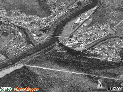
Streams, rivers, and creeks: Mill Fall Run (A), Booths Creek (B). Display/hide their locations on the map
Drinking water stations with addresses in Monongah and their reported violations in the past:
MONONGAH TOWN OF (Address: 271 HOLBERT ROAD , Population served: 3,171, Surface water):Past health violations:
- MCL, Average - Between JAN-2006 and MAR-2006, Contaminant: Total Haloacetic Acids (HAA5). Follow-up actions: St Compliance achieved (APR-24-2006), St Public Notif requested (MAY-27-2006), St Formal NOV issued (MAY-27-2006), St Public Notif received (AUG-17-2006)
- MCL, Average - Between OCT-2005 and DEC-2005, Contaminant: Total Haloacetic Acids (HAA5). Follow-up actions: St Compliance achieved (APR-24-2006), St Public Notif requested (JUN-20-2006), St Formal NOV issued (JUN-20-2006), St Public Notif received (JUL-21-2006)
- MCL, Average - Between JUL-2005 and SEP-2005, Contaminant: TTHM. Follow-up actions: St Compliance achieved (DEC-07-2005), St Public Notif requested (FEB-14-2006), St Formal NOV issued (FEB-14-2006), St Public Notif received (APR-14-2006)
| This town: | 2.3 people |
| West Virginia: | 2.4 people |
| This town: | 65.9% |
| Whole state: | 65.8% |
| This town: | 6.8% |
| Whole state: | 6.6% |
No gay or lesbian households reported
For population 15 years and over in Monongah:
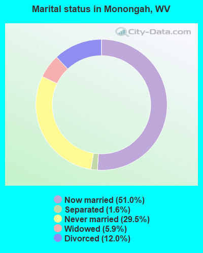
- Never married: 29.5%
- Now married: 51.0%
- Separated: 1.6%
- Widowed: 5.9%
- Divorced: 12.0%
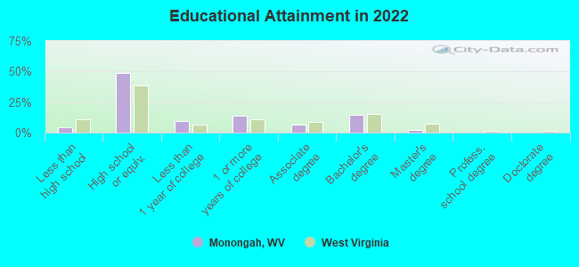
For population 25 years and over in Monongah:
- High school or higher: 95.2%
- Bachelor's degree or higher: 15.2%
- Graduate or professional degree: 2.1%
- Unemployed: 4.7%
- Mean travel time to work (commute): 23.2 minutes
| Here: | 8.3 |
| West Virginia average: | 11.1 |
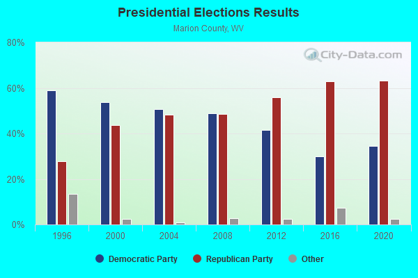
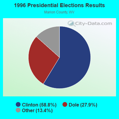
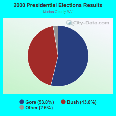
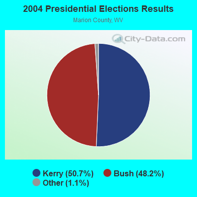
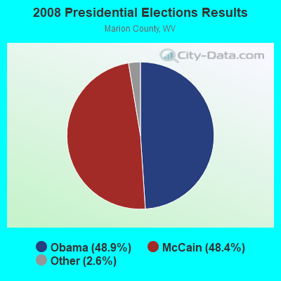
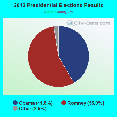
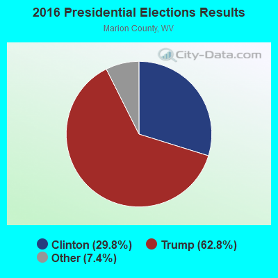
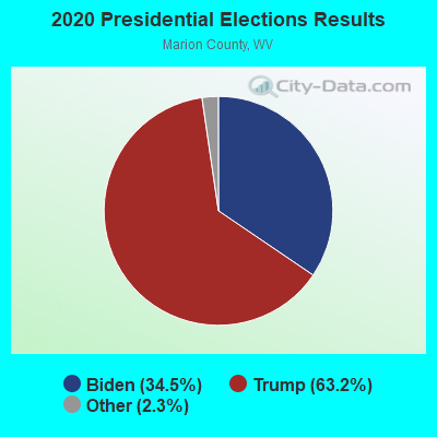
Graphs represent county-level data. Detailed 2008 Election Results
Religion statistics for Monongah, WV (based on Marion County data)
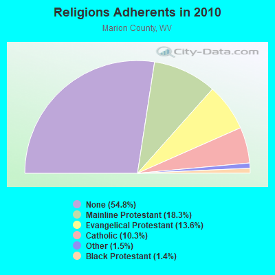
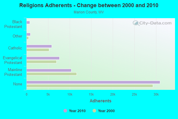
| Religion | Adherents | Congregations |
|---|---|---|
| Mainline Protestant | 10,344 | 73 |
| Evangelical Protestant | 7,649 | 55 |
| Catholic | 5,819 | 7 |
| Other | 873 | 3 |
| Black Protestant | 768 | 2 |
| Orthodox | 25 | 1 |
| None | 30,940 | - |
Food Environment Statistics:
| This county: | 1.77 / 10,000 pop. |
| West Virginia: | 2.41 / 10,000 pop. |
| Here: | 1.06 / 10,000 pop. |
| State: | 1.09 / 10,000 pop. |
| Marion County: | 5.82 / 10,000 pop. |
| West Virginia: | 5.38 / 10,000 pop. |
| Marion County: | 5.12 / 10,000 pop. |
| State: | 6.22 / 10,000 pop. |
| Marion County: | 10.0% |
| West Virginia: | 12.2% |
| Here: | 31.1% |
| State: | 31.1% |
| Marion County: | 11.6% |
| State: | 13.1% |
Health and Nutrition:
| Here: | 54.1% |
| West Virginia: | 51.8% |
| Monongah: | 52.7% |
| West Virginia: | 49.7% |
| This city: | 28.8 |
| West Virginia: | 28.6 |
| This city: | 21.3% |
| West Virginia: | 20.4% |
| Monongah: | 15.5% |
| West Virginia: | 9.7% |
| Monongah: | 7.0 |
| West Virginia: | 6.9 |
| Monongah: | 38.5% |
| State: | 34.8% |
| Monongah: | 58.1% |
| State: | 58.4% |
| This city: | 80.1% |
| West Virginia: | 78.6% |
More about Health and Nutrition of Monongah, WV Residents
| Local government employment and payroll (March 2022) | |||||
| Function | Full-time employees | Monthly full-time payroll | Average yearly full-time wage | Part-time employees | Monthly part-time payroll |
|---|---|---|---|---|---|
| Sewerage | 6 | $16,732 | $33,464 | 0 | $0 |
| Water Supply | 3 | $12,154 | $48,616 | 0 | $0 |
| Other Government Administration | 2 | $6,272 | $37,632 | 12 | $2,859 |
| Police Protection - Officers | 1 | $4,671 | $56,052 | 1 | $1,386 |
| Firefighters | 0 | $0 | 1 | $276 | |
| Totals for Government | 12 | $39,829 | $39,829 | 14 | $4,521 |
Monongah government finances - Expenditure in 2017 (per resident):
- Current Operations - Water Utilities: $694,000 ($683.07)
Sewerage: $173,000 ($170.28)
Police Protection: $115,000 ($113.19)
Health - Other: $97,000 ($95.47)
Regular Highways: $92,000 ($90.55)
Financial Administration: $35,000 ($34.45)
Judicial and Legal Services: $35,000 ($34.45)
Central Staff Services: $35,000 ($34.45)
General Public Buildings: $35,000 ($34.45)
- General - Interest on Debt: $1,000 ($0.98)
- Other Capital Outlay - Water Utilities: $376,000 ($370.08)
- Total Salaries and Wages: $334,000 ($328.74)
- Water Utilities - Interest on Debt: $164,000 ($161.42)
Monongah government finances - Revenue in 2017 (per resident):
- Charges - Sewerage: $227,000 ($223.43)
Other: $103,000 ($101.38)
- Miscellaneous - General Revenue - Other: $45,000 ($44.29)
Fines and Forfeits: $13,000 ($12.80)
Rents: $7,000 ($6.89)
Interest Earnings: $1,000 ($0.98)
- Revenue - Water Utilities: $745,000 ($733.27)
- State Intergovernmental - Other: $3,000 ($2.95)
General Local Government Support: $2,000 ($1.97)
Water Utilities: $2,000 ($1.97)
- Tax - Property: $171,000 ($168.31)
Other License: $16,000 ($15.75)
Monongah government finances - Debt in 2017 (per resident):
- Long Term Debt - Beginning Outstanding - Unspecified Public Purpose: $5,438,000 ($5352.36)
Outstanding Unspecified Public Purpose: $5,365,000 ($5280.51)
Retired Unspecified Public Purpose: $73,000 ($71.85)
Monongah government finances - Cash and Securities in 2017 (per resident):
- Other Funds - Cash and Securities: $88,000 ($86.61)
Businesses in Monongah, WV
- Circle K: 1
Strongest AM radio stations in Monongah:
- WMMN (920 AM; 5 kW; FAIRMONT, WV; Owner: FANTASIA BROADCASTING, INC.)
- WTCS (1490 AM; 1 kW; FAIRMONT, WV; Owner: FAIRMONT BROADCASTING COMPANY)
- WWVA (1170 AM; 53 kW; WHEELING, WV; Owner: CAPSTAR TX LIMITED PARTNERSHIP)
- WAJR (1440 AM; 5 kW; MORGANTOWN, WV; Owner: WEST VIRGINIA RADIO CORPORATION)
- KDKA (1020 AM; 50 kW; PITTSBURGH, PA; Owner: INFINITY BROADCASTING OPERATIONS, INC.)
- WCLG (1300 AM; 2 kW; MORGANTOWN, WV; Owner: BOWERS BROADCASTING CORP.)
- WOBG (1400 AM; 1 kW; CLARKSBURG, WV; Owner: BURBACH OF DE, LLC)
- WXKX (1340 AM; 1 kW; CLARKSBURG, WV; Owner: BURBACH OF DE, LLC)
- WPDX (750 AM; daytime; 1 kW; CLARKSBURG, WV; Owner: TSCHUDY BROADCASTING CORP.)
- WTVN (610 AM; 50 kW; COLUMBUS, OH; Owner: CITICASTERS LICENSES, L.P.)
- WBUC (1460 AM; 5 kW; BUCKHANNON, WV; Owner: CAT RADIO, INC.)
- WTBZ (1260 AM; 0 kW; GRAFTON, WV; Owner: APPALACHIAN RADIO LLC)
- WWCS (540 AM; 5 kW; CANONSBURG, PA; Owner: BIRACH BROADCASTING CORPORATION)
Strongest FM radio stations in Monongah:
- WGYE (102.7 FM; MANNINGTON, WV; Owner: BURBACH OF DE, LLC)
- WRLF (94.3 FM; FAIRMONT, WV; Owner: FAIRMONT BROADCASTING COMPANY)
- WBVQ (93.1 FM; BARRACKVILLE, WV; Owner: CAT RADIO, INC.)
- WKKW (97.9 FM; FAIRMONT, WV; Owner: DESCENDANTS TRUST, LAUREN M.KELLEY, TRUSTEE)
- WGIE (92.7 FM; CLARKSBURG, WV; Owner: BURBACH OF DE, LLC)
- WZWA (90.1 FM; CLARKSBURG, WV; Owner: MARANATHA BROADCASTING, INC.)
- WKJL (88.1 FM; CLARKSBURG, WV; Owner: HE'S ALIVE, INC.)
- WDCI (104.1 FM; BRIDGEPORT, WV; Owner: WDCI RADIO, INC)
- WAJR-FM (103.3 FM; SALEM, WV; Owner: WEST VIRGINIA RADIO CORPORATION OF SALEM)
- W220BZ (91.9 FM; CLARKSBURG, WV; Owner: EDUCATIONAL MEDIA FOUNDATION)
- WVPM (90.9 FM; MORGANTOWN, WV; Owner: WEST VIRGINIA EDUCATIONAL BROADCASTING AUTHORITY)
- WOBG-FM (105.7 FM; SALEM, WV; Owner: BURBACH OF DE, LLC)
- WPDX-FM (104.9 FM; CLARKSBURG, WV; Owner: TSCHUDY BROADCASTING CORP.)
- WWLW (106.5 FM; CLARKSBURG, WV; Owner: WEST VIRGINIA RADIO CORPORATION OF CLARKSBURG)
- WVAQ (101.9 FM; MORGANTOWN, WV; Owner: WEST VIRGINIA RADIO CORPORATION)
- WDKL (95.9 FM; GRAFTON, WV; Owner: EDUCATIONAL MEDIA FOUNDATION)
- WDBS (97.1 FM; SUTTON, WV; Owner: SUMMIT MEDIA BROADCASTING, L.L.C.)
- WRIJ (106.9 FM; MASONTOWN, PA; Owner: HE'S ALIVE INC.)
- WOGG (94.9 FM; OLIVER, PA; Owner: KEYMARKET LICENSES, LLC)
- WVPW (88.9 FM; BUCKHANNON, WV; Owner: WEST VIRGINIA EDUCATIONAL BROADCASTING AUTHORITY)
TV broadcast stations around Monongah:
- WVFX (Channel 46; CLARKSBURG, WV; Owner: DAVIS TELEVISION CLARKSBURG, LLC)
- WBOY-TV (Channel 12; CLARKSBURG, WV; Owner: WEST VIRGINIA MEDIA HOLDINGS, LLC)
- WDTV (Channel 5; WESTON, WV; Owner: WITHERS BROADCASTING COMPANY)
- WNPB-TV (Channel 24; MORGANTOWN, WV; Owner: WEST VIRGINIA EDUCATIONAL BROADCASTING AUTHORITY)
Monongah fatal accident list:
Sep 24, 1987 12:48 AM, 19, Vehicles: 2, Persons: 2, Fatalities: 1
- National Bridge Inventory (NBI) Statistics
- 9Number of bridges
- 82ft / 24.8mTotal length
- $4,787,000Total costs
- 10,550Total average daily traffic
- 784Total average daily truck traffic
- 14,035Total future (year 2037) average daily traffic
FCC Registered Broadcast Land Mobile Towers:
4- Hill 1200 Ft Corporate Limits (Lat: 39.464806 Lon: -80.208139), Call Sign: WGM939, Licensee ID: L00005237,
Assigned Frequencies: 456.950 MHz, Grant Date: 02/24/2000, Expiration Date: 05/14/2005, Cancellation Date: 04/11/2002, Registrant: Consolidation Coal Company, State Route 7 And State Route 19, Osage, WV 26543, Phone: (304) 296-3461
- Hill 1200 Ft Ne Corporate Limits (Lat: 39.464806 Lon: -80.208139), Call Sign: WGM942, Licensee ID: L00005237,
Assigned Frequencies: 456.925 MHz, Grant Date: 02/24/2000, Expiration Date: 05/15/2005, Cancellation Date: 04/11/2002, Registrant: Consolidation Coal Company, State Route 7 And Us Route 19, Osage, WV 26543, Phone: (304) 296-3461
- Hill 1200 Ft Ne Of Corporate Limit (Lat: 39.464806 Lon: -80.208139), Call Sign: WGM946, Licensee ID: L00005237,
Assigned Frequencies: 456.975 MHz, Grant Date: 02/24/2000, Expiration Date: 05/15/2005, Cancellation Date: 04/11/2002, Registrant: Consolidation Coal Company, State Route 7 And Us Route 19, Osage, WV 26543, Phone: (304) 296-3461
- CAROLINA TANK RTU-3, 0.2 Km West Of 8th St., ,0.4 Km West Of The 8th St./Co Route 52/1 Main St Inters (Lat: 39.482389 Lon: -80.281389), Type: Tank, Structure height: 9.1 m, Call Sign: WQMD964,
Assigned Frequencies: 154.456 MHz, Grant Date: 04/25/2020, Expiration Date: 07/12/2030, Certifier: Roger Huffman, Registrant: Siemens Water Technologies Corp, 1239 Willow Lake Blvd, Vadnais Heights, MN 55110, Phone: (651) 766-2700, Fax: (651) 766-2701, Email:
FCC Registered Paging Towers:
1- Tower Hill (Lat: 39.464806 Lon: -80.207833), Call Sign: KNKJ681, Licensee ID: L00000776,
Assigned Frequencies: 152.570 MHz, Expiration Date: 04/01/1999, Cancellation Date: 06/05/1999, Registrant: Shroyer M. Wayne Dba: Two-Way System Service, Route 2, Box 1500, Fairmont, WV 26554
FCC Registered Amateur Radio Licenses:
3- Call Sign: KD8VN, Previous Call Sign: KA8CQW, Licensee ID: L00214257, Grant Date: 03/03/2000, Expiration Date: 05/29/2010, Cancellation Date: 05/30/2012, Registrant: Robert N Morrison, Fleming Hill, Monongah, WV 26555
- Call Sign: W8YS, Previous Call Sign: KI8CC, Licensee ID: L00139687, Grant Date: 05/24/2017, Expiration Date: 08/21/2027, Certifier: Dennis J Bombardiere, Registrant: Dennis J Bombardiere, 721 Thomas Ave, Monongah, WV 26554
- Call Sign: KI8JB, Previous Call Sign: KC8JKX, Licensee ID: L00145027, Grant Date: 12/07/2017, Expiration Date: 03/04/2028, Certifier: Pamela S Bombardiere, Registrant: Pamela S Bombardiere, 721 Thomas Ave, Monongah, WV 26554
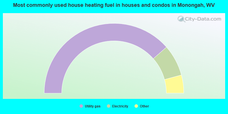
- 77.4%Utility gas
- 14.6%Electricity
- 3.6%Bottled, tank, or LP gas
- 3.3%Wood
- 1.2%No fuel used
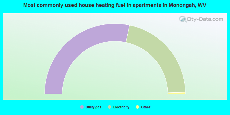
- 57.1%Utility gas
- 42.9%Electricity
Monongah compared to West Virginia state average:
- Median house value below state average.
- Unemployed percentage significantly below state average.
- Hispanic race population percentage significantly below state average.
- Foreign-born population percentage significantly below state average.
- Length of stay since moving in above state average.
- House age above state average.

|
Total of 1 patent application in 2008-2024.