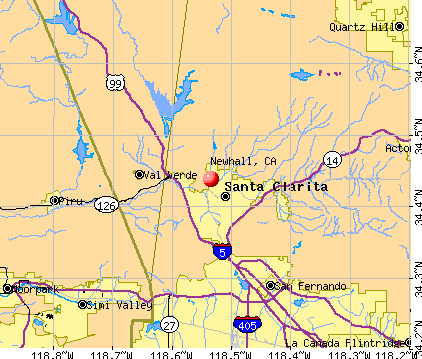
Newhall, California
Submit your own pictures of this place and show them to the world
- OSM Map
- General Map
- Google Map
- MSN Map
| Males: 99,627 | |
| Females: 93,353 |
| Median resident age: | 32.8 years |
| California median age: | 33.3 years |
Zip code: 91354
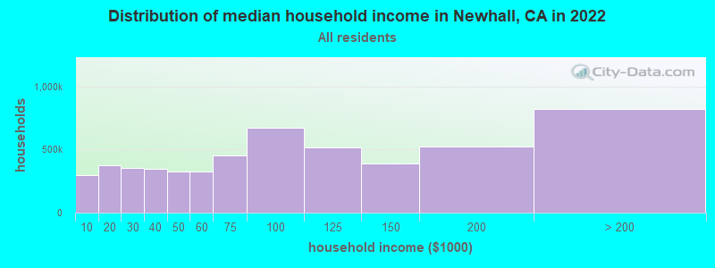
| Newhall: | $130,730 |
| CA: | $91,551 |
Estimated per capita income in 2022: $56,365 (it was $27,004 in 2000)
Newhall CCD income, earnings, and wages data
Estimated median house or condo value in 2022: $886,000 (it was $221,500 in 2000)
| Newhall: | $886,000 |
| CA: | $715,900 |
Mean prices in 2022: all housing units: over $1,000,000; detached houses: over $1,000,000; townhouses or other attached units: $750,854; in 2-unit structures: over $1,000,000; in 3-to-4-unit structures: $791,642; in 5-or-more-unit structures: $738,503; mobile homes: $205,184; occupied boats, rvs, vans, etc.: $276,239
Detailed information about poverty and poor residents in Newhall, CA


Compare current foreclosures near Newhall, CA:
| Photo | Address | Area | Beds / Baths | Price | Details |
|---|---|---|---|---|---|

|
#1
Friendly Valley Pkwy
Newhall, CA 91321
|
1,844 sq. feet
|
3 baths 4 beds |
show details | |

|
#2
Cherry Ridge Drive
Newhall, CA 91321
|
2,547 sq. feet
|
3 baths 4 beds |
show details | |

|
#3
Cherry St
Newhall, CA 91321
|
2,352 sq. feet
|
3 baths 4 beds |
show details | |

|
#4
Oakleaf Canyon Dr
Newhall, CA 91321
|
2,960 sq. feet
|
3 baths 5 beds |
show details | |

|
#5
Ebelden Ave
Newhall, CA 91321
|
2,913 sq. feet
|
3 baths 5 beds |
show details | |

|
#6
Dalton St
Newhall, CA 91321
|
1,811 sq. feet
|
2 baths 4 beds |
show details | |

|
#7
Oak Garden Ct
Newhall, CA 91321
|
1,077 sq. feet
|
2 baths 1 beds |
show details | |

|
#8
Santa Maria Dr
Newhall, CA 91321
|
1,812 sq. feet
|
3 baths 3 beds |
show details | |

|
#9
Placerita Canyon Rd
Newhall, CA 91321
|
2,378 sq. feet
|
3 baths 4 beds |
show details | |

|
#10
Hilse Ln
Newhall, CA 91321
|
1,536 sq. feet
|
2 baths 3 beds |
show details |
| Photo | Address | Area | Beds / Baths | Price | Details |
|---|---|---|---|---|---|

|
#11
Azure Field Dr
Newhall, CA 91321
|
1,708 sq. feet
|
3 baths 3 beds |
show details | |

|
#12
Apple St Unit F
Newhall, CA 91321
|
- sq. feet
|
- baths - beds |
show details | |

|
#13
Cleardale St
Newhall, CA 91321
|
- sq. feet
|
- baths - beds |
show details | |

|
#14
Valley St Apt 1003a
Newhall, CA 91321
|
- sq. feet
|
- baths - beds |
show details | |

|
#15
Hawkbryn Ave Spc 87
Newhall, CA 91321
|
- sq. feet
|
- baths - beds |
show details | |

|
#16
Newhall Ave Apt 46
Newhall, CA 91321
|
- sq. feet
|
- baths - beds |
show details | |

|
#17
Piazza Di Sarro
Newhall, CA 91321
|
- sq. feet
|
- baths - beds |
show details | |

|
#18
Wildwood Canyon Rd
Newhall, CA 91321
|
- sq. feet
|
- baths - beds |
show details | |

|
#19
Walnut St Apt 9
Newhall, CA 91321
|
- sq. feet
|
- baths - beds |
show details | |

|
#20
Vista Del Canon Unit C
Newhall, CA 91321
|
- sq. feet
|
- baths - beds |
show details |
| Photo | Address | Area | Beds / Baths | Price | Details |
|---|---|---|---|---|---|

|
#21
Calahan St
Panorama City, CA 91402
|
1,652 sq. feet
|
2 baths 3 beds |
$660,400
|
show details |

|
#22
Correnti St
Pacoima, CA 91331
|
1,206 sq. feet
|
2 baths 3 beds |
$595,000
|
show details |

|
#23
Hayvenhurst Ave
North Hills, CA 91343
|
2,110 sq. feet
|
4 baths 4 beds |
show details | |

|
#24
Bergstrom Pl
Sylmar, CA 91342
|
2,269 sq. feet
|
3 baths 4 beds |
show details | |

|
#25
Foothill Blvd Unit 28
Sylmar, CA 91342
|
1,233 sq. feet
|
3 baths 3 beds |
show details | |

|
#26
Birchwood Ct
Sylmar, CA 91342
|
2,277 sq. feet
|
3 baths 4 beds |
show details | |

|
#27
Sylmar Ave Unit 3
Panorama City, CA 91402
|
1,813 sq. feet
|
3 baths 3 beds |
show details | |

|
#28
Wilbur Ave
Northridge, CA 91324
|
2,259 sq. feet
|
2 baths 4 beds |
show details | |

|
#29
Doss Ct
Granada Hills, CA 91344
|
2,493 sq. feet
|
3 baths 5 beds |
show details | |

|
#30
Correnti St
Pacoima, CA 91331
|
1,780 sq. feet
|
2 baths 4 beds |
show details |
| Photo | Address | Area | Beds / Baths | Price | Details |
|---|---|---|---|---|---|

|
#31
Pocahantas Dr
Castaic, CA 91384
|
1,590 sq. feet
|
2 baths 3 beds |
show details | |

|
#32
Kilfinan St
Northridge, CA 91326
|
2,814 sq. feet
|
3 baths 4 beds |
show details | |

|
#33
Wolfe Cir
Stevenson Ranch, CA 91381
|
2,363 sq. feet
|
3 baths 4 beds |
show details | |

|
#34
Cherry Laurel Pl
Canyon Country, CA 91387
|
3,876 sq. feet
|
4 baths 5 beds |
show details | |

|
#35
Bryce Dr
Castaic, CA 91384
|
1,897 sq. feet
|
3 baths 4 beds |
show details | |

|
#36
Schoenborn St
Winnetka, CA 91306
|
1,330 sq. feet
|
2 baths 3 beds |
show details | |

|
#37
Bryant St
Canoga Park, CA 91304
|
3,193 sq. feet
|
3 baths 3 beds |
show details | |

|
#38
Bridlewood Dr
Castaic, CA 91384
|
2,230 sq. feet
|
3 baths 4 beds |
show details | |

|
#39
Muledeer Ln
Castaic, CA 91384
|
1,736 sq. feet
|
3 baths 4 beds |
show details | |

|
#40
Horse Creek Ave
Sunland, CA 91040
|
3,880 sq. feet
|
3 baths 4 beds |
show details |
| Photo | Address | Area | Beds / Baths | Price | Details |
|---|---|---|---|---|---|

|
#41
Sundowner Way
Canyon Country, CA 91387
|
844 sq. feet
|
2 baths 3 beds |
show details | |

|
#42
Wentworth St
Pacoima, CA 91331
|
1,622 sq. feet
|
1 baths 3 beds |
show details | |

|
#43
Creekview Rd
Granada Hills, CA 91344
|
4,231 sq. feet
|
5 baths 5 beds |
show details | |

|
#44
Amestoy Ave
Van Nuys, CA 91406
|
1,100 sq. feet
|
2 baths 3 beds |
show details | |

|
#45
Santa Catarina Rd
Santa Clarita, CA 91350
|
2,169 sq. feet
|
3 baths 3 beds |
show details | |

|
#46
White Wing Way
Santa Clarita, CA 91350
|
2,328 sq. feet
|
3 baths 5 beds |
show details | |

|
#47
Rex St
Sylmar, CA 91342
|
2,405 sq. feet
|
4 baths 5 beds |
show details | |

|
#48
Pinney St
Pacoima, CA 91331
|
1,743 sq. feet
|
2 baths 3 beds |
show details | |

|
#49
Mountain Ranch Rd
Granada Hills, CA 91344
|
3,277 sq. feet
|
4 baths 4 beds |
show details | |

|
Check over 1 million property listings on Foreclosure.com!
|
browse all offers | |||

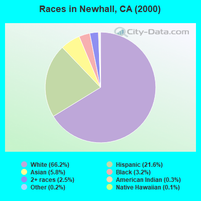
- 125,26466.2%White alone
- 40,83521.6%Hispanic
- 10,9335.8%Asian alone
- 6,1043.2%Black alone
- 4,7102.5%Two or more races
- 6420.3%American Indian alone
- 4530.2%Other race alone
- 2310.1%Native Hawaiian and Other
Pacific Islander alone
According to our research of California and other state lists, there were 21 registered sex offenders living in Newhall, California as of April 27, 2024.
The ratio of all residents to sex offenders in Newhall is 9,190 to 1.
The ratio of registered sex offenders to all residents in this city is much lower than the state average.
 Recent articles from our blog. Our writers, many of them Ph.D. graduates or candidates, create easy-to-read articles on a wide variety of topics.
Current Local Time: PST time zone
Elevation: 1272 feet
Land area: 496.7 square miles.
Population density: 389 people per square mile (very low).
| Newhall CCD: | 1.1% ($2,409) |
| California: | 0.8% ($1,564) |
Nearest city with pop. 200,000+: Los Angeles, CA  (26.0 miles , pop. 3,694,820).
Nearest cities:
), ), ), ), ), )Latitude: 34.44 N, Longitude: 118.53 W

Newhall tourist attractions:
| Here: | 5.0% |
| California: | 5.1% |
- Educational services (9.7%)
- Professional, scientific, technical services (7.1%)
- Health care (6.6%)
- Construction (6.1%)
- Finance & insurance (5.8%)
- Public administration (5.0%)
- Publishing, motion picture & sound recording industries (4.9%)
- Construction (9.4%)
- Professional, scientific, technical services (6.6%)
- Publishing, motion picture & sound recording industries (6.4%)
- Public administration (6.3%)
- Educational services (5.5%)
- Finance & insurance (4.4%)
- Accommodation & food services (4.3%)
- Educational services (14.8%)
- Health care (11.1%)
- Professional, scientific, technical services (7.6%)
- Finance & insurance (7.6%)
- Accommodation & food services (5.3%)
- Administrative & support & waste management services (3.8%)
- Public administration (3.5%)
- Other management occupations, except farmers and farm managers (5.3%)
- Other sales and related occupations, including supervisors (4.5%)
- Other office and administrative support workers, including supervisors (3.8%)
- Preschool, kindergarten, elementary, and middle school teachers (3.3%)
- Sales representatives, services, wholesale and manufacturing (3.1%)
- Secretaries and administrative assistants (3.1%)
- Top executives (2.8%)
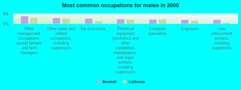
- Other management occupations, except farmers and farm managers (6.3%)
- Other sales and related occupations, including supervisors (4.9%)
- Top executives (4.3%)
- Electrical equipment mechanics and other installation, maintenance, and repair workers, including supervisors (4.0%)
- Computer specialists (3.7%)
- Engineers (3.4%)
- Law enforcement workers, including supervisors (3.4%)
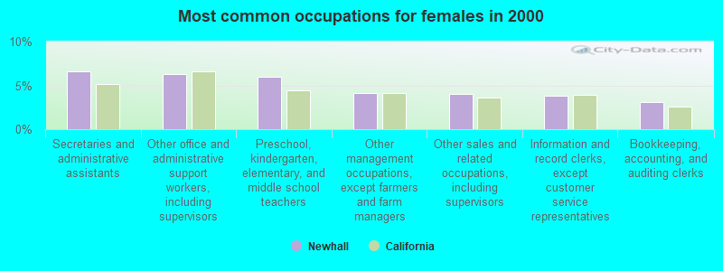
- Secretaries and administrative assistants (6.6%)
- Other office and administrative support workers, including supervisors (6.3%)
- Preschool, kindergarten, elementary, and middle school teachers (6.0%)
- Other management occupations, except farmers and farm managers (4.2%)
- Other sales and related occupations, including supervisors (4.0%)
- Information and record clerks, except customer service representatives (3.8%)
- Bookkeeping, accounting, and auditing clerks (3.1%)
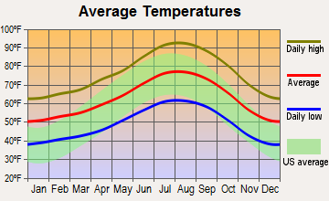
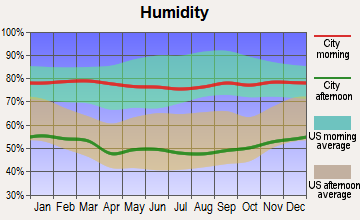
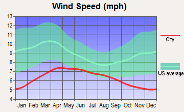
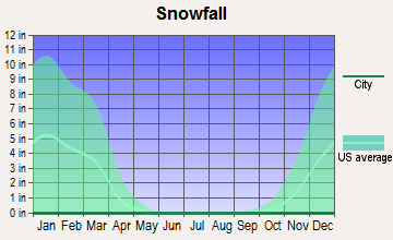
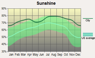
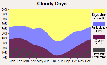
Average climate in Newhall, California
Based on data reported by over 4,000 weather stations
(lower is better)
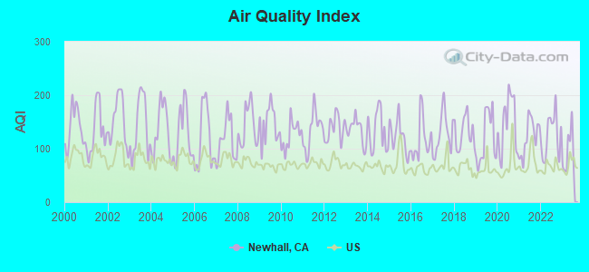
Air Quality Index (AQI) level in 2023 was 93.9. This is worse than average.
| City: | 93.9 |
| U.S.: | 72.6 |
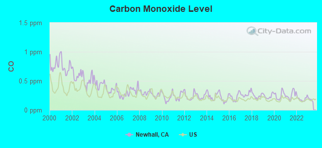
Carbon Monoxide (CO) [ppm] level in 2022 was 0.192. This is better than average. Closest monitor was 2.3 miles away from the city center.
| City: | 0.192 |
| U.S.: | 0.251 |
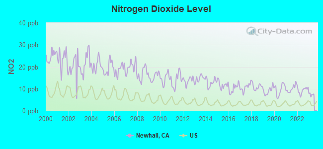
Nitrogen Dioxide (NO2) [ppb] level in 2022 was 9.29. This is significantly worse than average. Closest monitor was 2.3 miles away from the city center.
| City: | 9.29 |
| U.S.: | 5.11 |
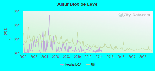
Sulfur Dioxide (SO2) [ppb] level in 2013 was 0.336. This is significantly better than average. Closest monitor was 2.3 miles away from the city center.
| City: | 0.336 |
| U.S.: | 1.515 |
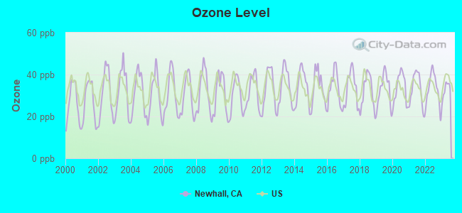
Ozone [ppb] level in 2023 was 32.5. This is about average. Closest monitor was 2.3 miles away from the city center.
| City: | 32.5 |
| U.S.: | 33.3 |
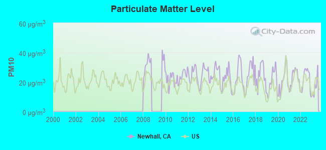
Particulate Matter (PM10) [µg/m3] level in 2023 was 16.7. This is about average. Closest monitor was 2.3 miles away from the city center.
| City: | 16.7 |
| U.S.: | 19.2 |
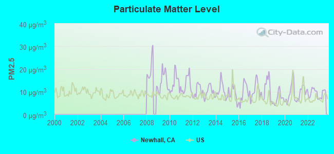
Particulate Matter (PM2.5) [µg/m3] level in 2023 was 9.09. This is about average. Closest monitor was 14.1 miles away from the city center.
| City: | 9.09 |
| U.S.: | 8.11 |
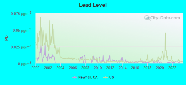
Lead (Pb) [µg/m3] level in 2023 was 0.00179. This is significantly better than average. Closest monitor was 14.0 miles away from the city center.
| City: | 0.00179 |
| U.S.: | 0.00931 |
Earthquake activity:
Newhall-area historical earthquake activity is significantly above California state average. It is 7254% greater than the overall U.S. average.On 7/21/1952 at 11:52:14, a magnitude 7.7 (7.7 UK, Class: Major, Intensity: VIII - XII) earthquake occurred 47.0 miles away from Newhall center, causing $50,000,000 total damage
On 6/28/1992 at 11:57:34, a magnitude 7.6 (6.2 MB, 7.6 MS, 7.3 MW, Depth: 0.7 mi) earthquake occurred 115.7 miles away from the city center, causing 3 deaths (1 shaking deaths, 2 other deaths) and 400 injuries, causing $100,000,000 total damage and $40,000,000 insured losses
On 10/16/1999 at 09:46:44, a magnitude 7.4 (6.3 MB, 7.4 MS, 7.2 MW, 7.3 ML) earthquake occurred 119.8 miles away from Newhall center
On 11/4/1927 at 13:51:53, a magnitude 7.5 (7.5 UK) earthquake occurred 145.8 miles away from the city center
On 1/17/1994 at 12:30:55, a magnitude 6.8 (6.4 MB, 6.8 MS, 6.7 MW, Depth: 11.4 mi, Class: Strong, Intensity: VII - IX) earthquake occurred 19.6 miles away from the city center, causing 60 deaths (60 shaking deaths) and 7000 injuries
On 6/28/1992 at 15:05:30, a magnitude 6.9 (6.3 MB, 6.7 MS, 6.5 MW, 6.9 ME, Depth: 3.1 mi) earthquake occurred 98.6 miles away from the city center
Magnitude types: body-wave magnitude (MB), energy magnitude (ME), local magnitude (ML), surface-wave magnitude (MS), moment magnitude (MW)
Natural disasters:
The number of natural disasters in Los Angeles County (57) is a lot greater than the US average (15).Major Disasters (Presidential) Declared: 27
Emergencies Declared: 3
Causes of natural disasters: Fires: 37, Floods: 16, Storms: 9, Winter Storms: 6, Landslides: 5, Mudslides: 5, Earthquakes: 3, Freeze: 1, Heavy Rain: 1, Hurricane: 1, Snow: 1, Tornado: 1, Wind: 1, Other: 1 (Note: some incidents may be assigned to more than one category).
Hospitals and medical centers in Newhall:
Other hospitals and medical centers near Newhall:
- HENRY MAYO NEWHALL MEMORIAL HOSPITAL Acute Care Hospitals (about 4 miles away; VALENCIA, CA)
- HENRY MAYO NEWHALL MEM HOSP DP (Nursing Home, about 4 miles away; VALENCIA, CA)
- SANTA CLARITA KIDNEY CENTER (Dialysis Facility, about 4 miles away; VALENCIA, CA)
- SANTA CLARITA HOME HEALTH (Home Health Center, about 5 miles away; SANTA CLARITA, CA)
- ABLE HOME HEALTH, INC (Home Health Center, about 6 miles away; SANTA CLARITA, CA)
- LAC/OLIVE VIEW-UCLA MEDICAL CENTER Acute Care Hospitals (about 10 miles away; SYLMAR, CA)
- ASTORIA NURSING AND REHAB CENT (Nursing Home, about 11 miles away; SYLMAR, CA)
Heliports located in Newhall:
Amtrak stations near Newhall:
- 6 miles: SANTA CLARITA (25259 THE OLD RD.) - Bus Station . Services: fully wheelchair accessible, enclosed waiting area, public restrooms, public payphones, full-service food facilities, free short-term parking, call for taxi service.
- 14 miles: CHATSWORTH (21510 DEVONSHIRE ST.) . Services: public payphones, free short-term parking, free long-term parking, taxi stand, public transit connection.
- 15 miles: SIMI VALLEY (5000 E. LOS ANGELES AVE.) . Services: public payphones, free short-term parking, call for taxi service, public transit connection.
Colleges/universities with over 2000 students nearest to Newhall:
- College of the Canyons (about 4 miles; Santa Clarita, CA; Full-time enrollment: 11,307)
- Los Angeles Mission College (about 11 miles; Sylmar, CA; FT enrollment: 4,825)
- California State University-Northridge (about 14 miles; Northridge, CA; FT enrollment: 28,060)
- Los Angeles Pierce College (about 18 miles; Woodland Hills, CA; FT enrollment: 10,996)
- Los Angeles Valley College (about 20 miles; Valley Glen, CA; FT enrollment: 9,459)
- Moorpark College (about 20 miles; Moorpark, CA; FT enrollment: 9,338)
- New York Film Academy (about 24 miles; Universal City, CA; FT enrollment: 4,714)
Public high school in Newhall:
- WILLIAM S. HART HIGH (Students: 1,516, Location: 24825 N. NEWHALL AVE., Grades: 9-12)
Public elementary/middle schools in Newhall:
- PLACERITA JUNIOR HIGH (Students: 986, Location: 25015 N. NEWHALL AVE., Grades: 7-8)
- WILEY CANYON ELEMENTARY (Students: 536, Location: 24240 LA GLORITA CIR., Grades: KG-6)
- NEWHALL ELEMENTARY (Students: 445, Location: 24607 N. WALNUT ST., Grades: KG-6)
- VALLEY VIEW ELEMENTARY (Students: 413, Location: 19414 SIERRA ESTATES DR., Grades: KG-6)
- DR. J. MICHAEL MCGRATH ELEMENTARY (Students: 410, Location: 21501 DEPUTY JAKE WAY, Grades: KG-6)
- PEACHLAND AVENUE ELEMENTARY (Students: 403, Location: 24800 PEACHLAND AVE., Grades: KG-6)
Private elementary/middle school in Newhall:
Points of interest:
Notable locations in Newhall: Texas Target Shooting Area (A), Texas Canyon Engineering Work Center (B), Savgus District Ranger Office (C), Las Cantilles Picnic Area (D), Zuni Campground (E), Bouquet Campground (F), Big Oaks Campground (G), Streamside Campground (H), Bouquet Campground Number Three (I), Dry Target Shooting Area (J), Tule Target Shooting Area (K), Kelly Ranch (L), Hathaway Ranch (M), Saugus Water Reclamation Plant (N), Valencia Water Reclamation Plant (O), Iverson Ranch (P), Elizabeth Lake Canyon Campground (Q), Elizabeth Lake Guard Station (R), Joe Scott Boys Camp (S), Kenyon Scudder Boys Camp (T). Display/hide their locations on the map
Shopping Centers: Valencia Mart Shopping Center (1), Valencia Mall Shopping Center (2), The Knoll Shopping Center (3), Sierra Plaza Shopping Center (4), Sierra Canyon Plaza Shopping Center (5), River Oaks Shopping Center (6), Old Orchard Shopping Center (7), Lyons Station Shopping Center (8), Granary Square Shopping Center (9). Display/hide their locations on the map
Churches in Newhall include: Hope Vineyard Church (A), Iglesia Hermano Unidos (B), First Christian Church (C), Santa Clarita Baptist Church (D), Bethlehem Lutheran Church (E), Saint Clare Catholic Church (F), Calvary Evangelical Lutheran Church (G), Church of Jesus Christ of Latter Day Saints (H), Saint Stephen's Episcopal Church (I). Display/hide their locations on the map
Reservoirs: Elderberry Lake (A), Drinkwater Reservoir (B), Dry Canyon Reservoir (C), Bouquet Reservoir (D), Castaic Lagoon (E), Elderberry Forebay (F), Castaic Lake (G). Display/hide their locations on the map
Rivers and creeks: Fish Creek (A), Newhall Creek (B), Castaic Creek (C), South Fork Santa Clara River (D), Salt Creek (E), Placerita Creek (F). Display/hide their locations on the map
Parks in Newhall include: Val Verde Park (1), H M Newhall Memorial Park (2), Castaic Lake State Recreation Area (3), Almendra Park (4), Bouquet Canyon Park (5), Camino Del Valle Park (6), Canyon Country Park (7), Emmaus Park (8), Hasley Canyon Park (9). Display/hide their locations on the map
Birthplace of: Greg Pursley - Racing driver.
| This place: | 3.0 people |
| California: | 2.9 people |
| This place: | 76.0% |
| Whole state: | 68.7% |
| This place: | 6.1% |
| Whole state: | 7.2% |
Likely homosexual households (counted as self-reported same-sex unmarried-partner households)
- Lesbian couples: 0.4% of all households
- Gay men: 0.4% of all households
| This place: | 6.3% |
| Whole state: | 14.2% |
| This place: | 2.9% |
| Whole state: | 6.3% |
People in group quarters in Newhall in 2010:
- 6,920 people in local jails and other municipal confinement facilities
- 1,061 people in college/university student housing
- 229 people in group homes intended for adults
- 168 people in residential treatment centers for adults
- 155 people in workers' group living quarters and job corps centers
- 152 people in correctional facilities intended for juveniles
- 113 people in nursing facilities/skilled-nursing facilities
- 74 people in state prisons
- 11 people in in-patient hospice facilities
- 7 people in group homes for juveniles (non-correctional)
- 7 people in other noninstitutional facilities
- 4 people in residential treatment centers for juveniles (non-correctional)
People in group quarters in Newhall in 2000:
- 7,113 people in local jails and other confinement facilities (including police lockups)
- 787 people in college dormitories (includes college quarters off campus)
- 370 people in nursing homes
- 161 people in other noninstitutional group quarters
- 146 people in training schools for juvenile delinquents
- 100 people in homes or halfway houses for drug/alcohol abuse
- 89 people in state prisons
- 85 people in homes for abused, dependent, and neglected children
- 48 people in homes for the mentally retarded
- 39 people in mental (psychiatric) hospitals or wards
- 39 people in institutions for the blind
- 38 people in hospitals or wards for drug/alcohol abuse
- 37 people in hospitals/wards and hospices for chronically ill
- 37 people in other hospitals or wards for chronically ill
- 33 people in institutions for the deaf
- 11 people in other nonhousehold living situations
- 9 people in other group homes
- 6 people in religious group quarters
Banks with branches in Newhall (2011 data):
- Wells Fargo Bank, National Association: Newhall Plaza at 24180 Lyons Avenue, branch established on 2006/12/11. Info updated 2011/04/05: Bank assets: $1,161,490.0 mil, Deposits: $905,653.0 mil, headquarters in Sioux Falls, SD, positive income, 6395 total offices, Holding Company: Wells Fargo & Company
- JPMorgan Chase Bank, National Association: 23402 W Lyons Ave Branch at 23402 W Lyons Ave, branch established on 1976/05/18. Info updated 2011/11/10: Bank assets: $1,811,678.0 mil, Deposits: $1,190,738.0 mil, headquarters in Columbus, OH, positive income, International Specialization, 5577 total offices, Holding Company: Jpmorgan Chase & Co.
- U.S. Bank National Association: Santa Clarita Branch at 26425 Sierra Hwy, branch established on 1986/06/30. Info updated 2012/01/30: Bank assets: $330,470.8 mil, Deposits: $236,091.5 mil, headquarters in Cincinnati, OH, positive income, 3121 total offices, Holding Company: U.S. Bancorp
- Bank of America, National Association: Newhall Branch at 24740 Valley Street, branch established on 1925/03/26. Info updated 2009/11/18: Bank assets: $1,451,969.3 mil, Deposits: $1,077,176.8 mil, headquarters in Charlotte, NC, positive income, 5782 total offices, Holding Company: Bank Of America Corporation
For population 15 years and over in Newhall:
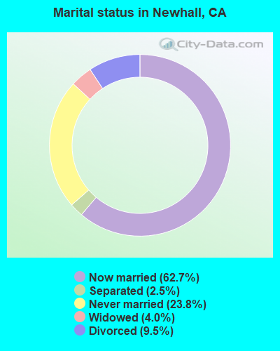
- Never married: 23.8%
- Now married: 62.7%
- Separated: 2.5%
- Widowed: 4.0%
- Divorced: 9.5%
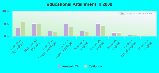
For population 25 years and over in Newhall:
- High school or higher: 86.8%
- Bachelor's degree or higher: 29.1%
- Graduate or professional degree: 8.7%
- Unemployed: 4.7%
- Mean travel time to work (commute): 32.3 minutes
| Here: | 11.2 |
| California average: | 16.1 |
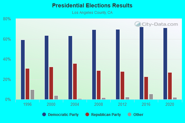
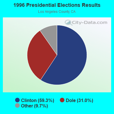
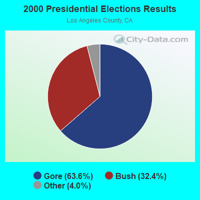
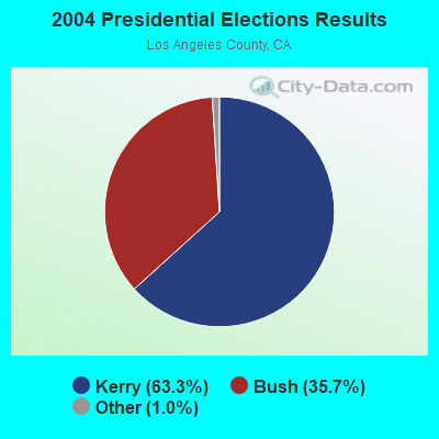
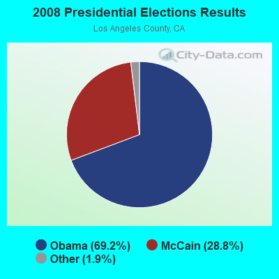

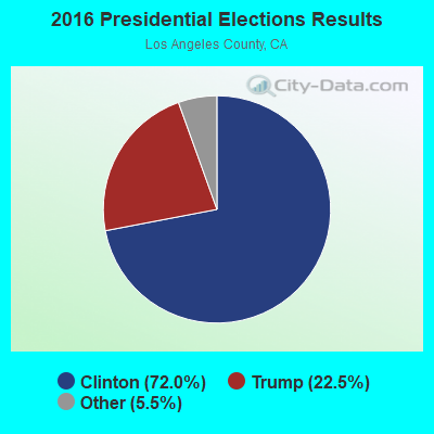
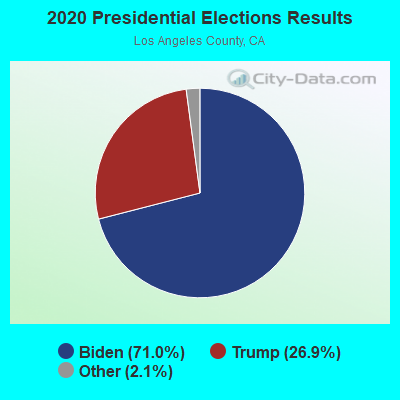
Graphs represent county-level data. Detailed 2008 Election Results
Religion statistics for Newhall, CA (based on Los Angeles County data)
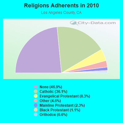
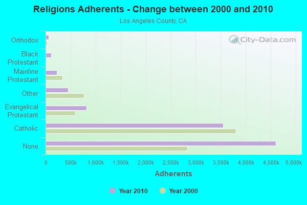
| Religion | Adherents | Congregations |
|---|---|---|
| Catholic | 3,542,994 | 275 |
| Evangelical Protestant | 814,611 | 3,249 |
| Other | 451,594 | 1,023 |
| Mainline Protestant | 229,056 | 860 |
| Black Protestant | 112,338 | 290 |
| Orthodox | 63,517 | 76 |
| None | 4,604,495 | - |
Food Environment Statistics:
| Los Angeles County: | 2.12 / 10,000 pop. |
| State: | 2.14 / 10,000 pop. |
| Los Angeles County: | 0.03 / 10,000 pop. |
| State: | 0.04 / 10,000 pop. |
| Los Angeles County: | 0.58 / 10,000 pop. |
| California: | 0.62 / 10,000 pop. |
| Here: | 1.23 / 10,000 pop. |
| California: | 1.49 / 10,000 pop. |
| Los Angeles County: | 7.15 / 10,000 pop. |
| California: | 7.42 / 10,000 pop. |
| Los Angeles County: | 7.5% |
| California: | 7.3% |
| Los Angeles County: | 20.4% |
| California: | 21.3% |
| Los Angeles County: | 18.6% |
| State: | 17.9% |
2.98% of this county's 2021 resident taxpayers lived in other counties in 2020 ($81,235 average adjusted gross income)
| Here: | 2.98% |
| California average: | 5.19% |
0.01% of residents moved from foreign countries ($155 average AGI)
Los Angeles County: 0.01% California average: 0.03%
Top counties from which taxpayers relocated into this county between 2020 and 2021:
| from Orange County, CA | |
| from San Bernardino County, CA | |
| from Riverside County, CA |
4.68% of this county's 2020 resident taxpayers moved to other counties in 2021 ($97,324 average adjusted gross income)
| Here: | 4.68% |
| California average: | 6.14% |
0.01% of residents moved to foreign countries ($196 average AGI)
Los Angeles County: 0.01% California average: 0.02%
Top counties to which taxpayers relocated from this county between 2020 and 2021:
| to Orange County, CA | |
| to San Bernardino County, CA | |
| to Riverside County, CA |
| Businesses in Newhall, CA | ||||
| Name | Count | Name | Count | |
|---|---|---|---|---|
| 7-Eleven | 2 | McDonald's | 1 | |
| 99 Cents Only Stores | 1 | Nike | 1 | |
| Baskin-Robbins | 1 | Outback | 1 | |
| Burger King | 1 | Outback Steakhouse | 1 | |
| Carl\s Jr. | 2 | Popeyes | 1 | |
| Circle K | 1 | RadioShack | 1 | |
| Curves | 1 | Safeway | 1 | |
| Dennys | 1 | T-Mobile | 1 | |
| Domino's Pizza | 1 | Taco Bell | 1 | |
| El Pollo Loco | 1 | The Room Place | 1 | |
| FedEx | 3 | Toys"R"Us | 1 | |
| Firestone Complete Auto Care | 1 | UPS | 4 | |
| Kincaid | 2 | Vans | 1 | |
| Little Caesars Pizza | 1 | Vons | 1 | |
Strongest AM radio stations in Newhall:
- KSPN (710 AM; 50 kW; LOS ANGELES, CA; Owner: KABC-AM RADIO, INC.)
- KSUR (1260 AM; 25 kW; BEVERLY HILLS, CA)
- KIRN (670 AM; 35 kW; SIMI VALLEY, CA; Owner: LOTUS OXNARD CORP.)
- KLAC (570 AM; 50 kW; LOS ANGELES, CA; Owner: AMFM RADIO LICENSES, L.L.C.)
- KACD (850 AM; 25 kW; THOUSAND OAKS, CA; Owner: CITICASTERS LICENSES, L.P.)
- KFWB (980 AM; 50 kW; LOS ANGELES, CA; Owner: INFINITY BROADCASTING OPERATIONS, INC.)
- KBLA (1580 AM; 50 kW; SANTA MONICA, CA)
- KMPC (1540 AM; 50 kW; LOS ANGELES, CA; Owner: ROSE CITY RADIO CORPORATION)
- KDIS (1110 AM; 50 kW; PASADENA, CA; Owner: ABC,INC.)
- KFI (640 AM; 50 kW; LOS ANGELES, CA; Owner: CAPSTAR TX LIMITED PARTNERSHIP)
- KRLA (870 AM; 20 kW; GLENDALE, CA; Owner: NEW INSPIRATION BROADCASTING COMPANY)
- KTNQ (1020 AM; 50 kW; LOS ANGELES, CA; Owner: KTNQ-AM LICENSE CORP.)
- KNX (1070 AM; 50 kW; LOS ANGELES, CA; Owner: INFINITY BROADCASTING OPERATIONS, INC.)
Strongest FM radio stations in Newhall:
- KCSN (88.5 FM; NORTHRIDGE, CA; Owner: CALIFORNIA STATE UNIVERSITY, NORTHRIDGE)
- K220FR (91.9 FM; SIMI VALLEY, CA; Owner: LIFE ON THE WAY COMMUNICATIONS, INC.)
- K261AB (100.1 FM; NEWHALL, ETC., CA; Owner: RADIO ONE LICENSES, LLC)
- KRTH-FM (101.1 FM; LOS ANGELES, CA; Owner: INFINITY BROADCASTING OPERATIONS, INC.)
- KKBT (100.3 FM; LOS ANGELES, CA; Owner: RADIO ONE LICENSES, LLC)
- KZLA-FM (93.9 FM; LOS ANGELES, CA; Owner: EMMIS RADIO LICENSE CORPORATION)
- KCBS-FM (93.1 FM; LOS ANGELES, CA; Owner: INFINITY BROADCASTING OPERATIONS, INC.)
- KPWR (105.9 FM; LOS ANGELES, CA; Owner: EMMIS RADIO LICENSE CORPORATION)
- KLSX (97.1 FM; LOS ANGELES, CA; Owner: INFINITY BROADCASTING OPERATIONS, INC.)
- KUSC (91.5 FM; LOS ANGELES, CA; Owner: UNIVERSITY OF SOUTHERN CALIFORNIA)
- KKLA-FM (99.5 FM; LOS ANGELES, CA; Owner: NEW INSPIRATION BROADCASTING CO., INC.)
- K202DJ (88.3 FM; PALMDALE, CA; Owner: SANTA MONICA COMMUNITY COLLEGE DIST.)
- KSCA (101.9 FM; GLENDALE, CA; Owner: HBC LICENSE CORPORATION)
- K212FA (90.3 FM; TEMPLE CITY, CA; Owner: EDUCATIONAL MEDIA FOUNDATION)
- KLOS (95.5 FM; LOS ANGELES, CA; Owner: KLOS-FM RADIO, INC.)
- KOST (103.5 FM; LOS ANGELES, CA; Owner: CAPSTAR TX LIMITED PARTNERSHIP)
- KLVE (107.5 FM; LOS ANGELES, CA; Owner: KLVE-FM LICENSE CORP.)
- KIIS-FM (102.7 FM; LOS ANGELES, CA; Owner: CITICASTERS LICENSES, L.P.)
- KPCC (89.3 FM; PASADENA, CA; Owner: PASADENA AREA COMMUNITY COLLEGE DISTRICT)
- KHHT (92.3 FM; LOS ANGELES, CA; Owner: AMFM RADIO LICENSES, L.L.C.)
TV broadcast stations around Newhall:
- KTRO-LP (Channel 50; LANCASTER, CA; Owner: ROBERT D. ADELMAN)
- KSMV-LP (Channel 33; LOS ANGELES, CA; Owner: KJLA, LLC)
- KCBS-TV (Channel 2; LOS ANGELES, CA; Owner: CBS BROADCASTING INC.)
- KSCI1 (Channel 18; SIMI VALLEY/NEWHALL, CA; Owner: KSLS, INC.)
- KNBC (Channel 4; LOS ANGELES, CA; Owner: NBC SUBSIDIARY (KNBC-TV), INC.)
- K38CY (Channel 38; VAN NUYS, CA; Owner: CAPITAL BROADCASTING CORPORATION)
Newhall fatal accident list:
May 3, 2007 06:42 PM, I-5, Templin Hwy, Lat: 34.569647, Lon: -118.687969, Vehicles: 1, Persons: 2, Fatalities: 1
FCC Registered Private Land Mobile Towers: 3 (See the full list of FCC Registered Private Land Mobile Towers in Newhall, CA)
FCC Registered Broadcast Land Mobile Towers: 25 (See the full list of FCC Registered Broadcast Land Mobile Towers)
FCC Registered Microwave Towers: 55 (See the full list of FCC Registered Microwave Towers in this town)
FCC Registered Paging Towers: 9 (See the full list of FCC Registered Paging Towers)
FCC Registered Maritime Coast & Aviation Ground Towers: 4 (See the full list of FCC Registered Maritime Coast & Aviation Ground Towers)
FCC Registered Amateur Radio Licenses: 163 (See the full list of FCC Registered Amateur Radio Licenses in Newhall)
FAA Registered Aircraft: 20 (See the full list of FAA Registered Aircraft in Newhall)
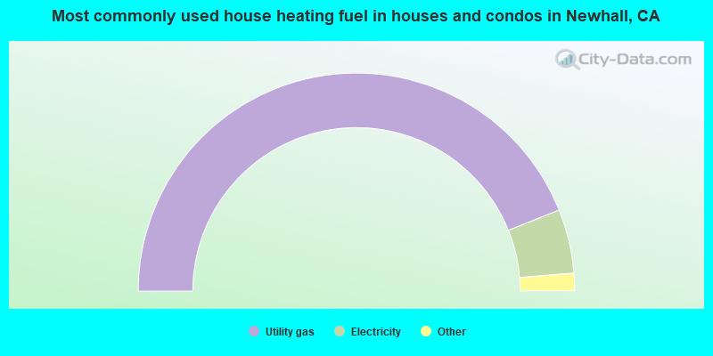
- 87.9%Utility gas
- 9.5%Electricity
- 1.9%Bottled, tank, or LP gas
- 0.4%Wood
- 0.2%No fuel used
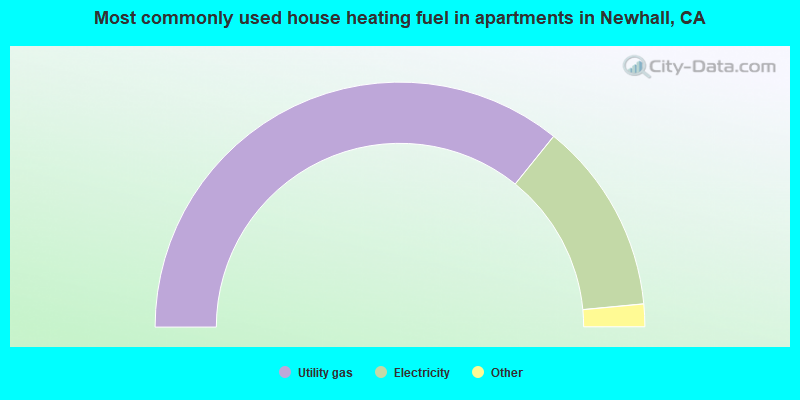
- 71.6%Utility gas
- 25.4%Electricity
- 1.8%Bottled, tank, or LP gas
- 0.8%No fuel used
- 0.2%Other fuel
- 0.1%Wood
Newhall compared to California state average:
- Unemployed percentage significantly below state average.
- Hispanic race population percentage below state average.
- Foreign-born population percentage significantly below state average.
- Renting percentage below state average.
- Length of stay since moving in significantly above state average.
- Number of rooms per house significantly below state average.
- House age significantly below state average.
- Institutionalized population percentage above state average.
Newhall, CA compared to other similar cities:
Newhall on our top lists:
- #1 on the list of "Top 101 cities with largest percentage of males in industries: publishing, and motion picture and sound recording industries (population 50,000+)"
- #3 on the list of "Top 101 cities with largest percentage of males in occupations: media and communication equipment workers (population 50,000+)"
- #5 on the list of "Top 101 cities with largest percentage of females in occupations: construction trades workers except carpenters, electricians, painters, plumbers, and construction laborers (population 50,000+)"
- #6 on the list of "Top 101 cities with largest percentage of females in industries: publishing, and motion picture and sound recording industries (population 50,000+)"
- #6 on the list of "Top 101 cities with largest percentage of males in occupations: art and design workers (population 50,000+)"
- #10 on the list of "Top 101 cities with largest percentage of males in occupations: entertainers and performers, sports, and related workers (population 50,000+)"
- #10 on the list of "Top 101 cities with largest percentage of males in occupations: therapists (population 50,000+)"
- #10 on the list of "Top 101 cities with largest percentage of females in industries: health and personal care, except drug, stores (population 50,000+)"
- #12 on the list of "Top 101 cities with largest percentage of males in industries: beverage and tobacco products (population 50,000+)"
- #12 on the list of "Top 101 cities with largest percentage of females in industries: drugs, sundries, and chemical and allied products merchant wholesalers (population 50,000+)"
- #12 on the list of "Top 101 cities with largest percentage of females in industries: metal and metal products (population 50,000+)"
- #15 on the list of "Top 101 cities with largest percentage of females in industries: motor vehicle and parts dealers (population 50,000+)"
- #15 on the list of "Top 101 cities with largest percentage of females in occupations: entertainers and performers, sports, and related workers (population 50,000+)"
- #15 on the list of "Top 100 cities with largest land areas (pop. 50,000+)"
- #16 on the list of "Top 101 cities with largest percentage of males in industries: sewing, needlework, and piece goods stores (population 50,000+)"
- #19 on the list of "Top 101 cities with largest percentage of males in industries: printing and related support activities (population 50,000+)"
- #19 on the list of "Top 101 cities with largest percentage of females in industries: beverage and tobacco products (population 50,000+)"
- #19 on the list of "Top 101 cities with largest percentage of females in industries: electrical and electronic goods merchant wholesalers (population 50,000+)"
- #20 on the list of "Top 101 cities with largest percentage of males in industries: miscellaneous manufacturing (population 50,000+)"
- #21 on the list of "Top 101 cities with largest percentage of females in industries: music stores (population 50,000+)"
- #1 on the list of "Top 101 counties with the most Evangelical Protestant congregations"
- #1 on the list of "Top 101 counties with the most Mainline Protestant congregations"
- #1 on the list of "Top 101 counties with the most Orthodox adherents"
- #1 on the list of "Top 101 counties with the highest ground withdrawal of fresh water for public supply (pop. 50,000+)"
- #1 on the list of "Top 101 counties with the most Catholic adherents (pop. 50,000+)"

|
|
Total of 165 patent applications in 2008-2024.