Porter, Indiana

Porter: View of porter at the dunes

Porter: Beverly Shores

Porter: Indiana Dunes at sunset

Porter: View of porter dunes
- add
your
Submit your own pictures of this town and show them to the world
- OSM Map
- General Map
- Google Map
- MSN Map
Population change since 2000: +4.8%
 |
| Males: 2,376 | |
| Females: 2,837 |
| Median resident age: | 44.9 years |
| Indiana median age: | 38.2 years |
Zip codes: 46304.
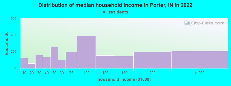
| Porter: | $77,669 |
| IN: | $66,785 |
Estimated per capita income in 2022: $37,637 (it was $24,615 in 2000)
Porter town income, earnings, and wages data
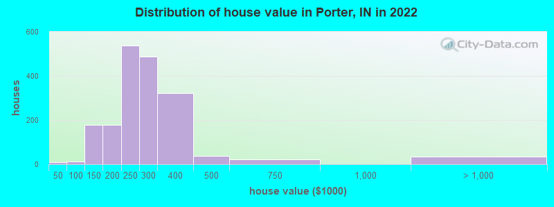
Estimated median house or condo value in 2022: $261,172 (it was $125,500 in 2000)
| Porter: | $261,172 |
| IN: | $208,700 |
Mean prices in 2022: all housing units: $310,414; detached houses: $323,400; townhouses or other attached units: $358,026; in 2-unit structures: $188,631; in 3-to-4-unit structures: $181,186; in 5-or-more-unit structures: $139,453; mobile homes: $20,095
Median gross rent in 2022: $1,102.
(5.7% for White Non-Hispanic residents, 6.8% for Hispanic or Latino residents, 2.0% for two or more races residents)
Detailed information about poverty and poor residents in Porter, IN
Compare current foreclosures near Porter, IN:
| Photo | Address | Area | Beds / Baths | Price | Details |
|---|---|---|---|---|---|

|
#1
W 53rd Ln
Merrillville, IN 46410
|
1,194 sq. feet
|
1 baths 3 beds |
$235,000
|
show details |

|
#2
W Coolspring Ave
Michigan City, IN 46360
|
720 sq. feet
|
1 baths 2 beds |
$144,500
|
show details |

|
#3
Ellsworth Pl
Gary, IN 46408
|
1,248 sq. feet
|
1 baths 2 beds |
$79,900
|
show details |

|
#4
Main St
Hobart, IN 46342
|
1,280 sq. feet
|
2 baths 3 beds |
show details | |

|
#5
Chase St
Gary, IN 46404
|
2,604 sq. feet
|
2 baths 3 beds |
show details | |

|
#6
Lahonda Dr
Valparaiso, IN 46385
|
1,176 sq. feet
|
1 baths 3 beds |
show details | |

|
#7
W 24th Pl
Gary, IN 46404
|
1,680 sq. feet
|
1 baths 3 beds |
show details | |

|
#8
Paw Paw Creek Ct
Valparaiso, IN 46385
|
952 sq. feet
|
1 baths 1 beds |
show details | |

|
#9
Newton St
Lake Station, IN 46405
|
772 sq. feet
|
1 baths 2 beds |
show details | |

|
#10
Poplar Ln
Hobart, IN 46342
|
2,020 sq. feet
|
2 baths 3 beds |
show details |
| Photo | Address | Area | Beds / Baths | Price | Details |
|---|---|---|---|---|---|

|
#11
Dearborn St
Lake Station, IN 46405
|
912 sq. feet
|
1 baths 3 beds |
show details | |

|
#12
W 16th Ave
Gary, IN 46404
|
1,044 sq. feet
|
1 baths 2 beds |
show details | |

|
#13
Stone Ave
Portage, IN 46368
|
1,244 sq. feet
|
2 baths 3 beds |
show details | |

|
#14
Meadow Lark Ln
Laporte, IN 46350
|
2,000 sq. feet
|
2 baths 3 beds |
show details | |

|
#15
Swanson Rd
Portage, IN 46368
|
1,284 sq. feet
|
2 baths 2 beds |
show details | |

|
#16
Glen Dr
Merrillville, IN 46410
|
1,499 sq. feet
|
2 baths 4 beds |
show details | |

|
#17
Nicklaus St
Crown Point, IN 46307
|
3,128 sq. feet
|
4 baths 4 beds |
show details | |

|
#18
N Union St
Hobart, IN 46342
|
2,275 sq. feet
|
2 baths 4 beds |
show details | |

|
#19
Fillmore St
Gary, IN 46402
|
1,635 sq. feet
|
1 baths 3 beds |
show details | |

|
#20
Woodview Dr
Valparaiso, IN 46383
|
1,484 sq. feet
|
2 baths 3 beds |
show details |
| Photo | Address | Area | Beds / Baths | Price | Details |
|---|---|---|---|---|---|

|
#21
6th St
Wheeler, IN 46393
|
1,166 sq. feet
|
1 baths 4 beds |
show details | |

|
#22
W 63rd Ave
Merrillville, IN 46410
|
1,782 sq. feet
|
2 baths 3 beds |
show details | |

|
#23
Minnesota St
Hobart, IN 46342
|
1,728 sq. feet
|
2 baths 4 beds |
show details | |

|
#24
Evergreen Ave
Portage, IN 46368
|
1,378 sq. feet
|
1 baths 3 beds |
show details | |

|
#25
Harrison St
Merrillville, IN 46410
|
1,229 sq. feet
|
1 baths 3 beds |
show details | |

|
#26
Dorothy Ct
Wanatah, IN 46390
|
1,470 sq. feet
|
2 baths 4 beds |
show details | |

|
#27
Jefferson Pl
Gary, IN 46408
|
1,210 sq. feet
|
1 baths 3 beds |
show details | |

|
#28
Floyd St
Lake Station, IN 46405
|
1,068 sq. feet
|
2 baths 6 beds |
show details | |

|
#29
Bies St
Michigan City, IN 46360
|
512 sq. feet
|
1 baths 2 beds |
show details | |

|
#30
Tyler St
Gary, IN 46402
|
1,637 sq. feet
|
2 baths 6 beds |
show details |
| Photo | Address | Area | Beds / Baths | Price | Details |
|---|---|---|---|---|---|

|
#31
Vigo St
Lake Station, IN 46405
|
1,224 sq. feet
|
1 baths 3 beds |
show details | |

|
#32
Saint Joseph Ct
Lake Station, IN 46405
|
780 sq. feet
|
1 baths 2 beds |
show details | |

|
#33
Fillmore St
Gary, IN 46408
|
1,824 sq. feet
|
1 baths 2 beds |
show details | |

|
#34
Mississippi St
Gary, IN 46402
|
750 sq. feet
|
1 baths 2 beds |
show details | |

|
#35
S Carroll Ave
Michigan City, IN 46360
|
910 sq. feet
|
1 baths 2 beds |
show details | |

|
#36
Lakewood Ave
Gary, IN 46403
|
1,248 sq. feet
|
2 baths 3 beds |
show details | |

|
#37
Heritage Rd
Valparaiso, IN 46385
|
1,064 sq. feet
|
1 baths 3 beds |
show details | |

|
#38
Rushmore Dr
Valparaiso, IN 46385
|
1,479 sq. feet
|
1 baths 3 beds |
show details | |

|
#39
Southwood Dr
Michigan City, IN 46360
|
1,025 sq. feet
|
1 baths 3 beds |
show details | |

|
#40
Quail Dr
Hobart, IN 46342
|
2,293 sq. feet
|
2 baths 3 beds |
show details |
| Photo | Address | Area | Beds / Baths | Price | Details |
|---|---|---|---|---|---|

|
#41
Woodbridge Ave
Portage, IN 46368
|
1,040 sq. feet
|
1 baths 3 beds |
show details | |

|
#42
W Ridge Rd
Gary, IN 46408
|
1,698 sq. feet
|
1 baths 3 beds |
show details | |

|
#43
High St
Hobart, IN 46342
|
2,640 sq. feet
|
1 baths 3 beds |
show details | |

|
#44
Laporte St
Hobart, IN 46342
|
1,900 sq. feet
|
2 baths 5 beds |
show details | |

|
#45
N Liberty St
Hobart, IN 46342
|
1,920 sq. feet
|
1 baths 3 beds |
show details | |

|
#46
Veronica St
Valparaiso, IN 46385
|
1,868 sq. feet
|
2 baths 3 beds |
show details | |

|
#47
Meagher St
Valparaiso, IN 46385
|
1,073 sq. feet
|
1 baths 3 beds |
show details | |

|
#48
Monroe St
Gary, IN 46408
|
1,910 sq. feet
|
1 baths 3 beds |
show details | |

|
#49
Glen Park Ave
Gary, IN 46408
|
6,362 sq. feet
|
3 baths 4 beds |
show details | |

|
Check over 1 million property listings on Foreclosure.com!
|
browse all offers | |||


- 4,22280.5%White alone
- 65612.5%Hispanic
- 2434.6%Two or more races
- 681.3%Asian alone
- 300.6%Black alone
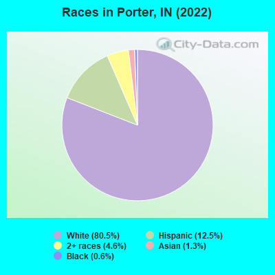
Races in Porter detailed stats: ancestries, foreign born residents, place of birth
Type |
2010 |
2011 |
2012 |
2013 |
2014 |
2015 |
2016 |
2017 |
2018 |
2019 |
2020 |
2021 |
2022 |
|---|---|---|---|---|---|---|---|---|---|---|---|---|---|
| Murders (per 100,000) | 0 (0.0) | 1 (20.5) | 0 (0.0) | 0 (0.0) | 0 (0.0) | 0 (0.0) | 0 (0.0) | 0 (0.0) | 0 (0.0) | 0 (0.0) | 0 (0.0) | 0 (0.0) | 0 (0.0) |
| Rapes (per 100,000) | 0 (0.0) | 2 (41.0) | 2 (40.7) | 0 (0.0) | 0 (0.0) | 0 (0.0) | 1 (20.5) | 3 (61.9) | 0 (0.0) | 1 (20.7) | 0 (0.0) | 0 (0.0) | 0 (0.0) |
| Robberies (per 100,000) | 0 (0.0) | 0 (0.0) | 0 (0.0) | 0 (0.0) | 0 (0.0) | 0 (0.0) | 0 (0.0) | 1 (20.6) | 0 (0.0) | 0 (0.0) | 0 (0.0) | 0 (0.0) | 4 (76.1) |
| Assaults (per 100,000) | 4 (82.3) | 3 (61.4) | 7 (142.6) | 1 (20.5) | 4 (81.6) | 3 (61.4) | 3 (61.5) | 5 (103.2) | 1 (20.8) | 7 (145.2) | 0 (0.0) | 3 (62.0) | 6 (114.1) |
| Burglaries (per 100,000) | 11 (226.4) | 31 (634.9) | 15 (305.5) | 9 (184.3) | 8 (163.3) | 4 (81.9) | 8 (163.9) | 6 (123.9) | 2 (41.6) | 3 (62.2) | 4 (82.8) | 1 (20.7) | 1 (19.0) |
| Thefts (per 100,000) | 67 (1,379) | 58 (1,188) | 52 (1,059) | 71 (1,454) | 58 (1,184) | 44 (900.5) | 38 (778.4) | 30 (619.5) | 19 (394.8) | 19 (394.1) | 26 (538.1) | 14 (289.3) | 14 (266.3) |
| Auto thefts (per 100,000) | 4 (82.3) | 10 (204.8) | 13 (264.8) | 6 (122.9) | 4 (81.6) | 2 (40.9) | 1 (20.5) | 3 (61.9) | 7 (145.5) | 1 (20.7) | 7 (144.9) | 8 (165.3) | 2 (38.0) |
| Arson (per 100,000) | 1 (20.6) | 1 (20.5) | 1 (20.4) | 0 (0.0) | 0 (0.0) | 0 (0.0) | 0 (0.0) | 0 (0.0) | 0 (0.0) | 0 (0.0) | 1 (20.7) | 0 (0.0) | 1 (19.0) |
| City-Data.com crime index | 94.1 | 194.3 | 146.0 | 85.0 | 81.6 | 57.3 | 72.9 | 114.8 | 34.5 | 67.4 | 38.9 | 38.6 | 60.7 |
The City-Data.com crime index weighs serious crimes and violent crimes more heavily. Higher means more crime, U.S. average is 246.1. It adjusts for the number of visitors and daily workers commuting into cities.
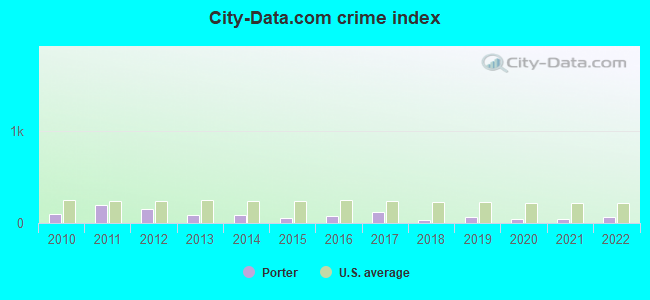
Crime rate in Porter detailed stats: murders, rapes, robberies, assaults, burglaries, thefts, arson
Full-time law enforcement employees in 2020, including police officers: 14 (11 officers - 10 male; 1 female).
| Officers per 1,000 residents here: | 2.28 |
| Indiana average: | 2.12 |
 Recent articles from our blog. Our writers, many of them Ph.D. graduates or candidates, create easy-to-read articles on a wide variety of topics.

 | The rise of Northwest Indiana in the Chicagoland area (87 replies) |
| NWI vs. Indy (35 replies) |
| Chicago family looking for some land, space, and chickens in NWI (6 replies) |
| Charter School Growth in Porter County (5 replies) |
| Porter County Growth (8 replies) |
| Portage Homes for Sale? (9 replies) |
Latest news from Porter, IN collected exclusively by city-data.com from local newspapers, TV, and radio stations
Ancestries: German (22.9%), Irish (10.6%), English (10.1%), Polish (6.7%), Dutch (5.0%), Italian (3.7%).
Current Local Time: CST time zone
Incorporated in 1908
Elevation: 640 feet
Land area: 6.30 square miles.
Population density: 827 people per square mile (low).
116 residents are foreign born (0.8% Latin America, 0.7% Asia, 0.6% Europe).
| This town: | 2.2% |
| Indiana: | 5.6% |
Median real estate property taxes paid for housing units with mortgages in 2022: $1,827 (0.7%)
Median real estate property taxes paid for housing units with no mortgage in 2022: $2,301 (0.9%)
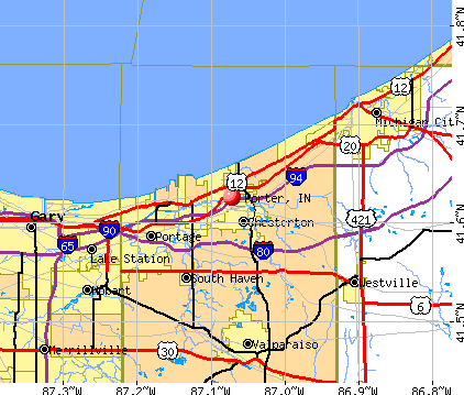
Nearest city with pop. 50,000+: Gary, IN  (14.5 miles , pop. 102,746).
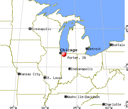
Nearest city with pop. 200,000+: Chicago, IL (34.7 miles , pop. 2,896,016).
Nearest cities:
), ), )Latitude: 41.63 N, Longitude: 87.07 W
Area code commonly used in this area: 219
Porter tourist attractions:
Porter, Indiana accommodation & food services, waste management - Economy and Business Data
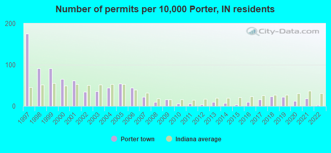
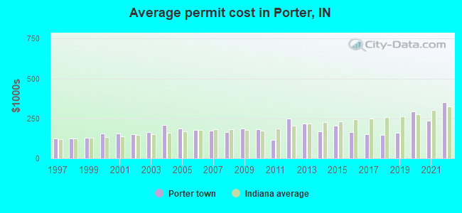
Single-family new house construction building permits:
- 2022: 1 building, cost: $350,000
- 2021: 9 buildings, average cost: $238,300
- 2020: 6 buildings, average cost: $294,200
- 2019: 11 buildings, average cost: $158,200
- 2018: 12 buildings, average cost: $147,100
- 2017: 8 buildings, average cost: $153,400
- 2016: 5 buildings, average cost: $164,100
- 2015: 2 buildings, average cost: $205,000
- 2014: 4 buildings, average cost: $167,100
- 2013: 5 buildings, average cost: $217,700
- 2012: 2 buildings, average cost: $250,000
- 2011: 3 buildings, average cost: $113,700
- 2010: 3 buildings, average cost: $182,600
- 2009: 8 buildings, average cost: $189,400
- 2008: 5 buildings, average cost: $165,000
- 2007: 11 buildings, average cost: $172,400
- 2006: 22 buildings, average cost: $179,800
- 2005: 27 buildings, average cost: $185,500
- 2004: 22 buildings, average cost: $211,200
- 2003: 18 buildings, average cost: $163,700
- 2002: 17 buildings, average cost: $152,100
- 2001: 31 buildings, average cost: $157,300
- 2000: 33 buildings, average cost: $157,400
- 1999: 45 buildings, average cost: $127,300
- 1998: 45 buildings, average cost: $123,100
- 1997: 87 buildings, average cost: $122,500
| Here: | 3.2% |
| Indiana: | 2.8% |
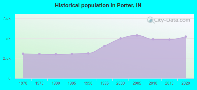
Population change in the 1990s: +1,719 (+52.8%).
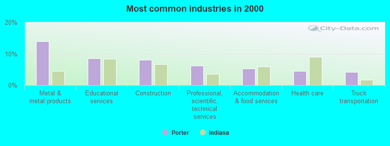
- Metal & metal products (13.9%)
- Educational services (8.5%)
- Construction (8.1%)
- Professional, scientific, technical services (6.3%)
- Accommodation & food services (5.2%)
- Health care (4.5%)
- Truck transportation (4.2%)
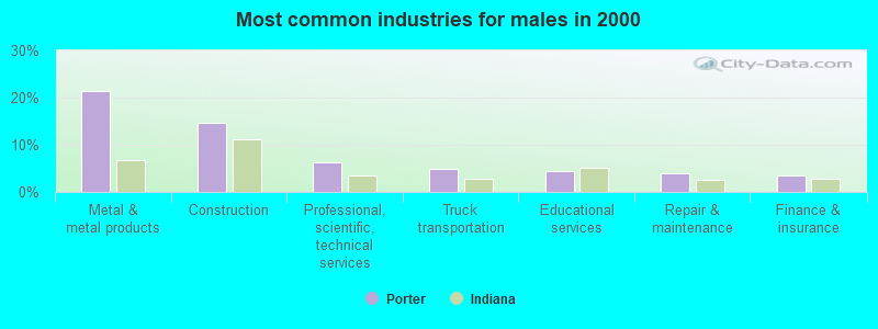
- Metal & metal products (21.4%)
- Construction (14.6%)
- Professional, scientific, technical services (6.2%)
- Truck transportation (4.8%)
- Educational services (4.5%)
- Repair & maintenance (3.9%)
- Finance & insurance (3.5%)
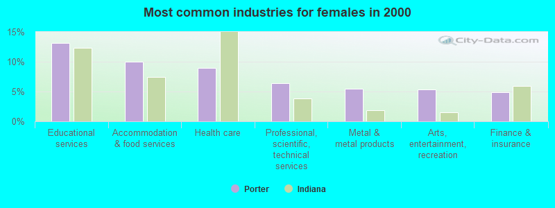
- Educational services (13.1%)
- Accommodation & food services (10.0%)
- Health care (8.9%)
- Professional, scientific, technical services (6.4%)
- Metal & metal products (5.4%)
- Arts, entertainment, recreation (5.3%)
- Finance & insurance (4.9%)
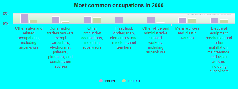
- Other sales and related occupations, including supervisors (5.9%)
- Construction traders workers except carpenters, electricians, painters, plumbers, and construction laborers (4.4%)
- Other production occupations, including supervisors (4.3%)
- Preschool, kindergarten, elementary, and middle school teachers (4.2%)
- Other office and administrative support workers, including supervisors (4.2%)
- Metal workers and plastic workers (3.9%)
- Electrical equipment mechanics and other installation, maintenance, and repair workers, including supervisors (3.5%)
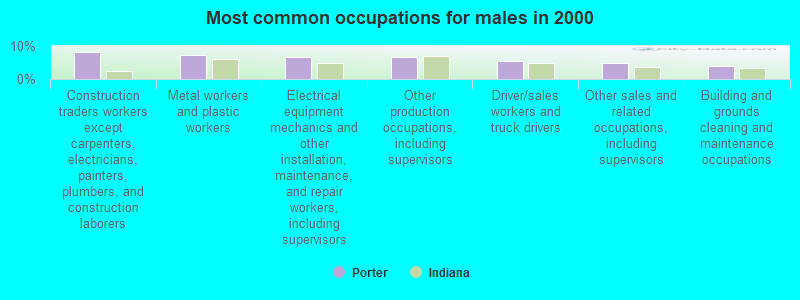
- Construction traders workers except carpenters, electricians, painters, plumbers, and construction laborers (8.2%)
- Metal workers and plastic workers (7.3%)
- Electrical equipment mechanics and other installation, maintenance, and repair workers, including supervisors (6.5%)
- Other production occupations, including supervisors (6.5%)
- Driver/sales workers and truck drivers (5.4%)
- Other sales and related occupations, including supervisors (4.9%)
- Building and grounds cleaning and maintenance occupations (4.1%)

- Preschool, kindergarten, elementary, and middle school teachers (7.9%)
- Other office and administrative support workers, including supervisors (7.7%)
- Other sales and related occupations, including supervisors (7.1%)
- Retail sales workers, except cashiers (4.8%)
- Other management occupations, except farmers and farm managers (4.1%)
- Cooks and food preparation workers (3.9%)
- Secretaries and administrative assistants (3.8%)
Average climate in Porter, Indiana
Based on data reported by over 4,000 weather stations


(lower is better)
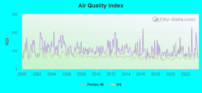
Air Quality Index (AQI) level in 2023 was 106. This is significantly worse than average.
| City: | 106 |
| U.S.: | 73 |
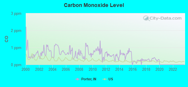
Carbon Monoxide (CO) [ppm] level in 2019 was 0.313. This is worse than average. Closest monitor was 13.7 miles away from the city center.
| City: | 0.313 |
| U.S.: | 0.251 |
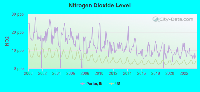
Nitrogen Dioxide (NO2) [ppb] level in 2023 was 6.64. This is worse than average. Closest monitor was 0.6 miles away from the city center.
| City: | 6.64 |
| U.S.: | 5.11 |
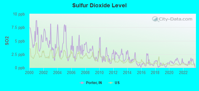
Sulfur Dioxide (SO2) [ppb] level in 2023 was 1.23. This is better than average. Closest monitor was 0.6 miles away from the city center.
| City: | 1.23 |
| U.S.: | 1.51 |
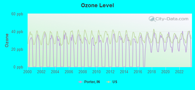
Ozone [ppb] level in 2023 was 33.0. This is about average. Closest monitor was 0.9 miles away from the city center.
| City: | 33.0 |
| U.S.: | 33.3 |

Particulate Matter (PM10) [µg/m3] level in 2023 was 24.3. This is worse than average. Closest monitor was 1.7 miles away from the city center.
| City: | 24.3 |
| U.S.: | 19.2 |
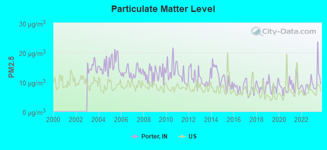
Particulate Matter (PM2.5) [µg/m3] level in 2023 was 11.1. This is worse than average. Closest monitor was 0.9 miles away from the city center.
| City: | 11.1 |
| U.S.: | 8.1 |
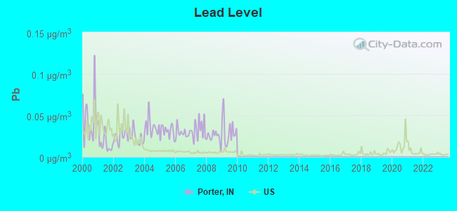
Lead (Pb) [µg/m3] level in 2009 was 0.0317. This is significantly worse than average. Closest monitor was 1.7 miles away from the city center.
| City: | 0.0317 |
| U.S.: | 0.0093 |
Tornado activity:
Porter-area historical tornado activity is slightly below Indiana state average. It is 57% greater than the overall U.S. average.
On 4/21/1967, a category F4 (max. wind speeds 207-260 mph) tornado 25.7 miles away from the Porter town center killed 33 people and injured 500 people and caused between $5,000,000 and $50,000,000 in damages.
On 3/12/1976, a category F3 (max. wind speeds 158-206 mph) tornado 7.3 miles away from the town center injured 7 people and caused between $50,000 and $500,000 in damages.
Earthquake activity:
Porter-area historical earthquake activity is significantly above Indiana state average. It is 29% greater than the overall U.S. average.On 4/18/2008 at 09:36:59, a magnitude 5.4 (5.1 MB, 4.8 MS, 5.4 MW, 5.2 MW, Class: Moderate, Intensity: VI - VII) earthquake occurred 223.7 miles away from the city center
On 6/10/1987 at 23:48:54, a magnitude 5.1 (4.9 MB, 4.4 MS, 4.6 MS, 5.1 LG) earthquake occurred 198.7 miles away from the city center
On 4/18/2008 at 09:36:59, a magnitude 5.2 (5.2 MW, Depth: 8.9 mi) earthquake occurred 223.8 miles away from the city center
On 5/2/2015 at 16:23:07, a magnitude 4.2 (4.2 MW, Depth: 2.8 mi, Class: Light, Intensity: IV - V) earthquake occurred 94.5 miles away from the city center
On 7/27/1980 at 18:52:21, a magnitude 5.2 (5.1 MB, 4.7 MS, 5.0 UK, 5.2 UK) earthquake occurred 289.0 miles away from the city center
On 6/28/2004 at 06:10:52, a magnitude 4.2 (4.2 MW, Depth: 6.2 mi) earthquake occurred 95.3 miles away from the city center
Magnitude types: regional Lg-wave magnitude (LG), body-wave magnitude (MB), surface-wave magnitude (MS), moment magnitude (MW)
Natural disasters:
The number of natural disasters in Porter County (12) is smaller than the US average (15).Major Disasters (Presidential) Declared: 6
Emergencies Declared: 4
Causes of natural disasters: Floods: 6, Storms: 5, Winter Storms: 4, Tornadoes: 2, Hurricane: 1, Snow: 1, Other: 1 (Note: some incidents may be assigned to more than one category).

Hospitals and medical centers in Porter:
Other hospitals and medical centers near Porter:
- OPPORTUNITY ENTERPRISES INC (Hospital, about 2 miles away; CHESTERTON, IN)
- WATERS OF DUNELAND THE (Nursing Home, about 3 miles away; CHESTERTON, IN)
- IN-PACT INC (Hospital, about 7 miles away; VALPARAISO, IN)
- ARC BRIDGES, INC (Hospital, about 7 miles away; PORTAGE, IN)
- OPPORTUNITY ENTERPRISES INC (Hospital, about 7 miles away; PORTAGE, IN)
- FOUNTAINVIEW PLACE OF PORTAGE (Nursing Home, about 8 miles away; PORTAGE, IN)
- GOLDEN LIVING CENTER-FOUNTAINVIEW PLACE (Nursing Home, about 8 miles away; PORTAGE, IN)
Colleges/universities with over 2000 students nearest to Porter:
- Purdue University-North Central Campus (about 10 miles; Westville, IN; Full-time enrollment: 3,682)
- Valparaiso University (about 12 miles; Valparaiso, IN; FT enrollment: 3,542)
- Indiana University-Northwest (about 15 miles; Gary, IN; FT enrollment: 4,390)
- Purdue University-Calumet Campus (about 21 miles; Hammond, IN; FT enrollment: 7,343)
- City Colleges of Chicago-Olive-Harvey College (about 28 miles; Chicago, IL; FT enrollment: 4,110)
- South Suburban College (about 29 miles; South Holland, IL; FT enrollment: 3,972)
- Chicago State University (about 29 miles; Chicago, IL; FT enrollment: 4,352)
Public elementary/middle schools in Porter:
- NEWTON YOST ELEMENTARY SCHOOL (Students: 420, Location: 100 W BEAM ST, Grades: KG-4)
- DISCOVERY CHARTER SCHOOL (Students: 32, Location: 800 CANONIE DR, Grades: KG-8, Charter school)
Points of interest:
Notable locations in Porter: Goodfellow Camp (A), Porter Fire Department (B), Indiana Dunes Lakeshore Fire Management (C), Mittal Steel Fire Department (D). Display/hide their locations on the map
Churches in Porter include: Augsburg Church (A), Porter Assembly of God Church (B). Display/hide their locations on the map
Cemeteries: Bailly Cemetery (1), Burstrom Cemetery (2). Display/hide their locations on the map
Lakes: Lake Florence (A), Pratt Lake (B), Lake Charles (C). Display/hide their locations on the map
Streams, rivers, and creeks: Peterson Ditch (A). Display/hide its location on the map
Parks in Porter include: Hawthorne Park (1), Indian Springs Park (2). Display/hide their locations on the map
Hotel: Spring House Inn (303 N Mineral Springs Rd).
Drinking water stations with addresses in Porter and their reported violations in the past:
SM&G INC. (Population served: 502, Groundwater):Past monitoring violations:
- 7 routine major monitoring violations
- 2 regular monitoring violations
| This town: | 2.6 people |
| Indiana: | 2.5 people |
| This town: | 71.5% |
| Whole state: | 66.9% |
| This town: | 7.9% |
| Whole state: | 6.9% |
Likely homosexual households (counted as self-reported same-sex unmarried-partner households)
- Lesbian couples: 0.3% of all households
- Gay men: 0.3% of all households
Banks with branches in Porter (2011 data):
- First State Bank of Porter: First State Bank Of Porter at 230 Lincoln Street, branch established on 1920/04/01. Info updated 2006/11/03: Bank assets: $161.3 mil, Deposits: $143.2 mil, local headquarters, positive income, 3 total offices
For population 15 years and over in Porter:
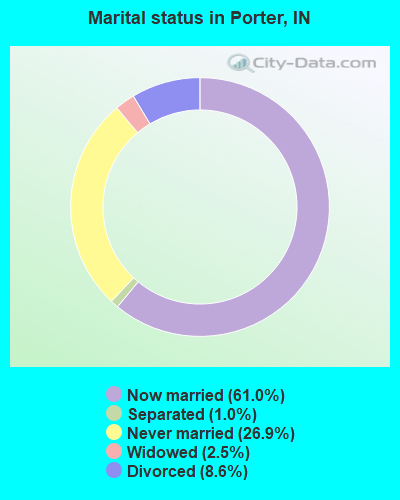
- Never married: 26.9%
- Now married: 61.0%
- Separated: 1.0%
- Widowed: 2.5%
- Divorced: 8.6%
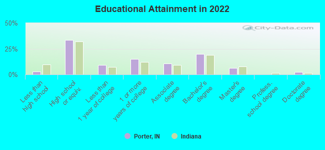
For population 25 years and over in Porter:
- High school or higher: 97.0%
- Bachelor's degree or higher: 28.1%
- Graduate or professional degree: 9.1%
- Unemployed: 5.5%
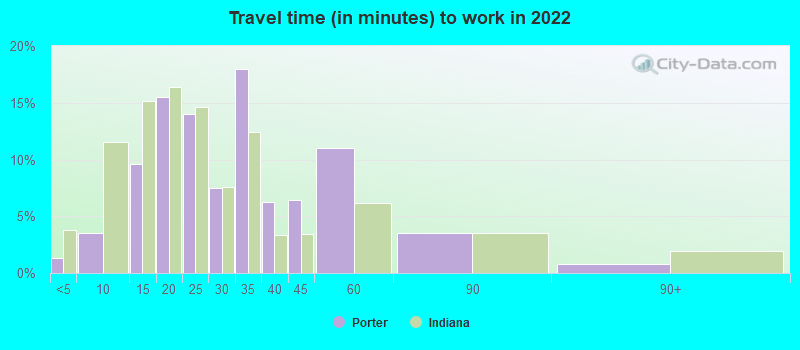
- Mean travel time to work (commute): 22.6 minutes
| Here: | 8.6 |
| Indiana average: | 11.3 |
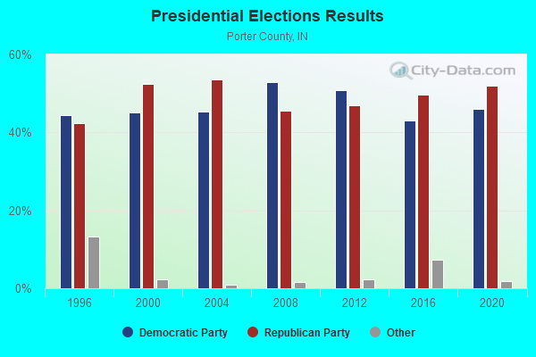
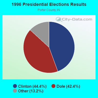
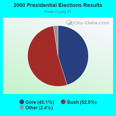
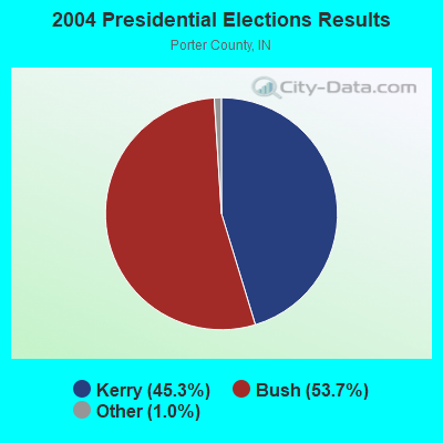
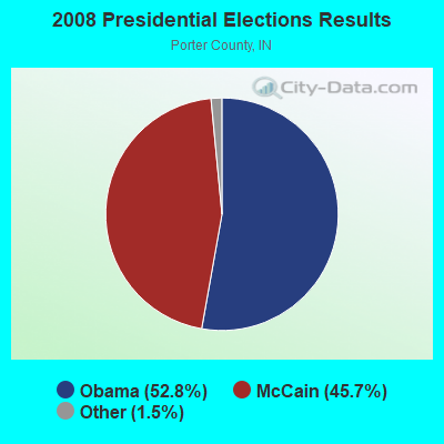
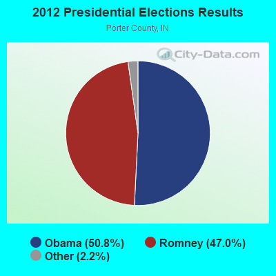
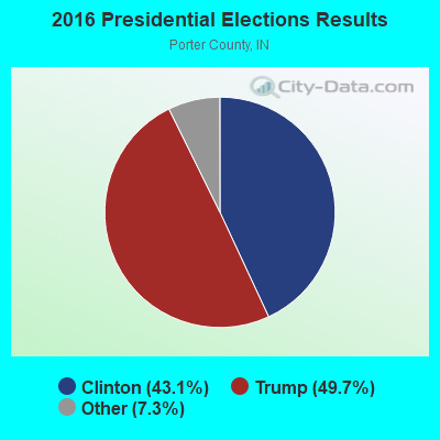
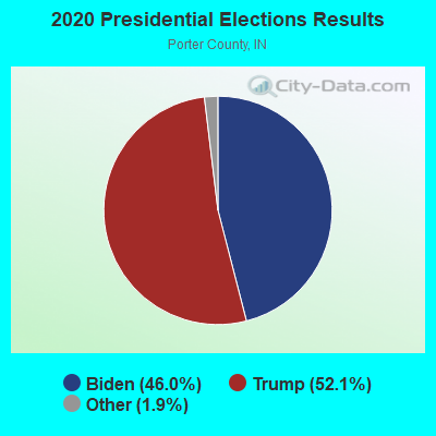
Graphs represent county-level data. Detailed 2008 Election Results
Religion statistics for Porter, IN (based on Porter County data)
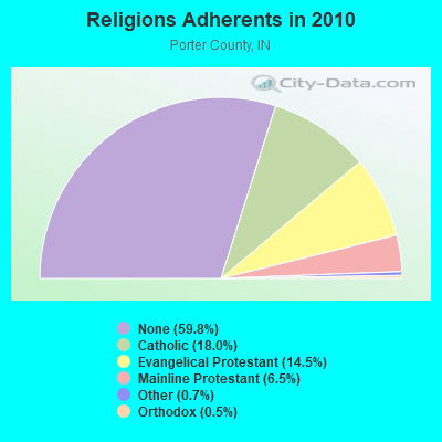
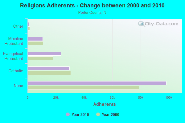
| Religion | Adherents | Congregations |
|---|---|---|
| Catholic | 29,583 | 8 |
| Evangelical Protestant | 23,857 | 91 |
| Mainline Protestant | 10,640 | 26 |
| Other | 1,136 | 7 |
| Orthodox | 860 | 2 |
| None | 98,267 | - |
Food Environment Statistics:
| Here: | 0.81 / 10,000 pop. |
| Indiana: | 1.73 / 10,000 pop. |
| Porter County: | 0.12 / 10,000 pop. |
| State: | 0.21 / 10,000 pop. |
| This county: | 0.19 / 10,000 pop. |
| Indiana: | 0.50 / 10,000 pop. |
| This county: | 3.62 / 10,000 pop. |
| State: | 3.57 / 10,000 pop. |
| Porter County: | 6.55 / 10,000 pop. |
| Indiana: | 6.78 / 10,000 pop. |
| Porter County: | 9.0% |
| Indiana: | 9.2% |
| Porter County: | 28.6% |
| Indiana: | 29.0% |
| This county: | 12.6% |
| Indiana: | 14.3% |
Health and Nutrition:
| Porter: | 51.0% |
| Indiana: | 49.3% |
| Porter: | 50.3% |
| Indiana: | 46.2% |
| Porter: | 28.7 |
| State: | 28.7 |
| Porter: | 20.8% |
| Indiana: | 21.3% |
| Porter: | 8.9% |
| State: | 10.6% |
| Porter: | 6.8 |
| Indiana: | 6.8 |
| Porter: | 34.6% |
| Indiana: | 33.9% |
| Porter: | 59.4% |
| State: | 56.1% |
| Porter: | 80.6% |
| Indiana: | 78.7% |
More about Health and Nutrition of Porter, IN Residents
| Local government employment and payroll (March 2022) | |||||
| Function | Full-time employees | Monthly full-time payroll | Average yearly full-time wage | Part-time employees | Monthly part-time payroll |
|---|---|---|---|---|---|
| Police Protection - Officers | 12 | $73,152 | $73,152 | 4 | $3,997 |
| Streets and Highways | 6 | $25,067 | $50,134 | 0 | $0 |
| Sewerage | 5 | $21,798 | $52,315 | 0 | $0 |
| Police - Other | 4 | $13,879 | $41,637 | 13 | $11,606 |
| Other Government Administration | 4 | $16,653 | $49,959 | 1 | $3,984 |
| Firefighters | 1 | $6,838 | $82,056 | 0 | $0 |
| Parks and Recreation | 1 | $6,683 | $80,196 | 3 | $7,651 |
| Housing and Community Development (Local) | 0 | $0 | 1 | $4,242 | |
| Other and Unallocable | 0 | $0 | 1 | $4,242 | |
| Totals for Government | 33 | $164,070 | $59,662 | 23 | $35,722 |
Porter government finances - Expenditure in 2021 (per resident):
- Current Operations - Police Protection: $1,685,000 ($323.23)
Sewerage: $1,248,000 ($239.40)
General - Other: $1,077,000 ($206.60)
Regular Highways: $641,000 ($122.96)
Financial Administration: $433,000 ($83.06)
Local Fire Protection: $235,000 ($45.08)
Parks and Recreation: $188,000 ($36.06)
Public Welfare - Other: $86,000 ($16.50)
- General - Interest on Debt: $285,000 ($54.67)
- Other Capital Outlay - Regular Highways: $208,000 ($39.90)
Porter government finances - Revenue in 2021 (per resident):
- Charges - Sewerage: $2,746,000 ($526.76)
Parks and Recreation: $14,000 ($2.69)
Other: $3,000 ($0.58)
- Local Intergovernmental - Highways: $103,000 ($19.76)
Other: $24,000 ($4.60)
- Miscellaneous - Fines and Forfeits: $5,000 ($0.96)
Donations From Private Sources: $3,000 ($0.58)
General Revenue - Other: $2,000 ($0.38)
- State Intergovernmental - Highways: $1,237,000 ($237.29)
General Local Government Support: $259,000 ($49.68)
Other: $23,000 ($4.41)
- Tax - Property: $2,798,000 ($536.74)
Other License: $163,000 ($31.27)
Porter government finances - Debt in 2021 (per resident):
- Long Term Debt - Outstanding Unspecified Public Purpose: $7,140,000 ($1369.65)
Beginning Outstanding - Unspecified Public Purpose: $7,140,000 ($1369.65)
Porter government finances - Cash and Securities in 2021 (per resident):
- Bond Funds - Cash and Securities: $980,000 ($187.99)
- Other Funds - Cash and Securities: $11,963,000 ($2294.84)
- Sinking Funds - Cash and Securities: $24,000 ($4.60)
| Businesses in Porter, IN | ||||
| Name | Count | Name | Count | |
|---|---|---|---|---|
| Comfort Inn | 1 | Popeyes | 1 | |
| FedEx | 1 | Subway | 1 | |
Strongest AM radio stations in Porter:
- WNDZ (750 AM; daytime; 5 kW; PORTAGE, IN; Owner: ENTRAVISION HOLDINGS, LLC)
- WIMS (1420 AM; 5 kW; MICHIGAN CITY, IN; Owner: ST. GEORGE BROADCASTING, LLC, ROBERT J. MACCINI, RECEIVER)
- WLS (890 AM; 50 kW; CHICAGO, IL; Owner: WLS, INC.)
- WIND (560 AM; 5 kW; CHICAGO, IL; Owner: TICHENOR LICENSE CORPORATION ("TLC"))
- WSCR (670 AM; 50 kW; CHICAGO, IL; Owner: INFINITY BROADCASTING OPERATIONS, INC.)
- WGN (720 AM; 50 kW; CHICAGO, IL; Owner: WGN CONTINENTAL BROADCASTING CO.)
- WMVP (1000 AM; 50 kW; CHICAGO, IL; Owner: ABC, INC.)
- WBBM (780 AM; 50 kW; CHICAGO, IL; Owner: INFINITY BROADCASTING OPERATIONS, INC.)
- WVIV (1200 AM; 20 kW; CHICAGO, IL; Owner: WLXX-AM LICENSE CORP.)
- WYLL (1160 AM; 50 kW; CHICAGO, IL; Owner: SCA LICENSE CORPORATION)
- WTMJ (620 AM; 50 kW; MILWAUKEE, WI; Owner: JOURNAL BROADCAST CORPORATION)
- WNTD (950 AM; 5 kW; CHICAGO, IL; Owner: RADIO UNICA OF CHICAGO LICENSE CORP.)
- WISN (1130 AM; 50 kW; MILWAUKEE, WI; Owner: CAPSTAR TX LIMITED PARTNERSHIP)
Strongest FM radio stations in Porter:
- WDSO (88.3 FM; CHESTERTON, IN; Owner: DUNELAND SCHOOL CORP.)
- WLJE (105.5 FM; VALPARAISO, IN; Owner: PORTER COUNTY BROADCASTING CORP.)
- WBEW (89.5 FM; CHESTERTON, IN; Owner: THE WBEZ ALLIANCE, INC.)
- WCKG (105.9 FM; ELMWOOD PARK, IL; Owner: INFINITY HOLDINGS CORPORATION OF ORLANDO)
- WLIT-FM (93.9 FM; CHICAGO, IL; Owner: AMFM RADIO LICENSES, L.L.C.)
- WJMK (104.3 FM; CHICAGO, IL; Owner: INFINITY BROADCASTING CORP. OF ILLINOIS)
- WNUA (95.5 FM; CHICAGO, IL; Owner: AMFM RADIO LICENSES, L.L.C.)
- WTMX (101.9 FM; SKOKIE, IL; Owner: BONNEVILLE HOLDING COMPANY)
- WBBM-FM (96.3 FM; CHICAGO, IL; Owner: INFINITY BROADCASTING OPERATIONS, INC.)
- WKSC-FM (103.5 FM; CHICAGO, IL; Owner: AMFM RADIO LICENSES, L.L.C.)
- WFMT (98.7 FM; CHICAGO, IL; Owner: WINDOW TO THE WORLD COMMUNICATIONS)
- WGCI-FM (107.5 FM; CHICAGO, IL; Owner: AMFM RADIO LICENSES, L.L.C.)
- WZZN (94.7 FM; CHICAGO, IL; Owner: ABC CHICAGO FM RADIO,INC.)
- WBEZ (91.5 FM; CHICAGO, IL; Owner: THE WBEZ ALLIANCE, INC.)
- WKQX (101.1 FM; CHICAGO, IL; Owner: EMMIS RADIO LICENSE CORPORATION)
- WLUP-FM (97.9 FM; CHICAGO, IL; Owner: BONNEVILLE HOLDING COMPANY)
- WNND (100.3 FM; CHICAGO, IL; Owner: BONNEVILLE HOLDING COMPANY)
- WOJO (105.1 FM; EVANSTON, IL; Owner: TICHENOR LICENSE CORPORATION ("TLC"))
- WUSN (99.5 FM; CHICAGO, IL; Owner: INFINITY BROADCASTING CORPORATION OF CHICAGO)
- WVAZ (102.7 FM; OAK PARK, IL; Owner: AMFM RADIO LICENSES, L.L.C.)
TV broadcast stations around Porter:
- W04CQ (Channel 4; CHESTERTON, IN; Owner: AQUA-LAND COMMUNICATIONS, INC.)
- W24AW (Channel 24; VALPARAISO, IN; Owner: LESEA BROADCASTING CORPORATION)
- W54BK (Channel 54; CHESTERTON, IN; Owner: LESEA BROADCASTING CORPORATION)
- WYIN (Channel 56; GARY, IN; Owner: NORTHWEST INDIANA PUBLIC BROADCASTING, INC.)
- WLS-TV (Channel 7; CHICAGO, IL; Owner: WLS TELEVISION, INC.)
- WMAQ-TV (Channel 5; CHICAGO, IL; Owner: NBC SUBSIDIARY (WMAQ-TV), INC.)
- WTTW (Channel 11; CHICAGO, IL; Owner: WINDOW TO THE WORLD COMMUNICATIONS, INC.)
- WGN-TV (Channel 9; CHICAGO, IL; Owner: WGN CONTINENTAL BROADCASTING COMPANY)
- WGBO-TV (Channel 66; JOLIET, IL; Owner: WGBO LICENSE PARTNERSHIP, G.P.)
- WBBM-TV (Channel 2; CHICAGO, IL; Owner: CBS BROADCASTING INC.)
- WPWR-TV (Channel 50; GARY, IN; Owner: FOX TELEVISION STATIONS, INC.)
- WXFT (Channel 60; AURORA, IL; Owner: TELEFUTURA CHICAGO LLC)
- WCPX (Channel 38; CHICAGO, IL; Owner: PAXSON CHICAGO LICENSE, INC.)
- WCIU-TV (Channel 26; CHICAGO, IL; Owner: WCIU-TV LIMITED PARTNERSHIP)
- WFLD (Channel 32; CHICAGO, IL; Owner: FOX TELEVISION STATIONS, INC.)
- W68DO (Channel 68; PALATINE, IL; Owner: TRINITY BROADCASTING NETWORK)
- WFBT-CA (Channel 23; CHICAGO, IL; Owner: CHANNEL 23 LIMITED PARTNERSHIP)
- WSNS-TV (Channel 44; CHICAGO, IL; Owner: TELEMUNDO OF CHICAGO, INC.)
- WJYS (Channel 62; HAMMOND, IN; Owner: JOVON BROADCASTING CORPORATION)
- WOCH-LP (Channel 28; CHICAGO, IL; Owner: KM LPTV OF CHICAGO-28, L.L.C.)
- WYCC (Channel 20; CHICAGO, IL; Owner: COLLEGE DIST. #508, COUNTY OF COOK)
- WOCK-CA (Channel 13; CHICAGO, IL; Owner: KM LPTV OF CHICAGO-13, L.L.C.)
- W18CF (Channel 18; ELKHART, IN; Owner: TRINITY BROADCASTING NETWORK)
- W13BQ (Channel 13; PORTAGE, IN; Owner: STUDIO 5, INC.)
- WBND-LP (Channel 57; SOUTH BEND, IN; Owner: WBND-TV LIMITED PARTNERSHIP)
- National Bridge Inventory (NBI) Statistics
- 28Number of bridges
- 276ft / 83.7mTotal length
- $1,461,000Total costs
- 355,586Total average daily traffic
- 44,666Total average daily truck traffic
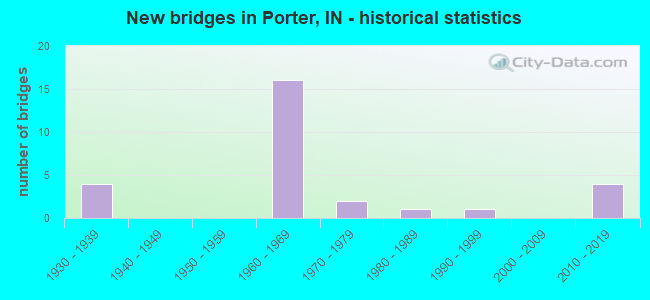
- New bridges - historical statistics
- 41930-1939
- 161960-1969
- 21970-1979
- 11980-1989
- 11990-1999
- 42010-2019
FCC Registered Cell Phone Towers:
1 (See the full list of FCC Registered Cell Phone Towers in Porter)FCC Registered Antenna Towers:
14 (See the full list of FCC Registered Antenna Towers)FCC Registered Broadcast Land Mobile Towers:
5- Cr Rofw At N 16th & Wood St (Lat: 41.613917 Lon: -87.075028), Type: Pole, Structure height: 15 m, Overall height: 18 m, Call Sign: WPMT702,
Assigned Frequencies: 160.230 MHz, Grant Date: 09/29/2023, Expiration Date: 12/16/2033, Certifier: Rae A Greene, Registrant: Csx Transportation, 6735 Southpoint Dr. S, Suite 400, Jacksonville, FL 32216, Phone: (904) 279-6938, Fax: (904) 332-6048, Email:
- Lat: 41.585889 Lon: -87.035083, Structure height: 0 m, Call Sign: WPXF895,
Assigned Frequencies: 451.762 MHz, Grant Date: 03/26/2003, Expiration Date: 03/26/2013, Cancellation Date: 06/01/2013, Certifier: Bernard Hasten, Registrant: Utc Spectrum Services, 200 North Glebe Rd. #1000, Arlingtin, VA 22203, Phone: (703) 558-2214, Fax: (703) 558-0523, Email:
- Lat: 41.616111 Lon: -87.067778, Call Sign: WQAZ429,
Assigned Frequencies: 451.312 MHz, 451.362 MHz, 451.387 MHz, 451.437 MHz, Grant Date: 06/12/2014, Expiration Date: 08/31/2024, Certifier: Tim Short, Registrant: Miner Electronics Corporation, 500 45th Ave., Munster, IN 46321, Phone: (219) 924-1765, Fax: (219) 924-1768, Email:
- 800 Canonie Dr (Lat: 41.638778 Lon: -87.052194), Type: Bant, Structure height: 9 m, Overall height: 12 m, Call Sign: WQMI432,
Assigned Frequencies: 157.740 MHz, Grant Date: 08/16/2010, Expiration Date: 08/16/2020, Cancellation Date: 10/17/2020, Certifier: Vito Bianco, Registrant: Visiplex, Inc., 100 N Fairway Drive, Suite 120, Vernon Hills, IL 60061, Phone: (847) 918-0250, Fax: (847) 918-0259, Email:
- L- 6 MOBILES, Lat: 41.614639 Lon: -87.086917, Call Sign: WQZF864,
Assigned Frequencies: 161.565 MHz, Grant Date: 05/04/2017, Expiration Date: 05/04/2027, Certifier: Jerry R Celio, Registrant: Norfolk Southern Railway Company, 1200 Peachtree St Ne, Box 123, Atlanta, GA 30309, Phone: (404) 582-6224, Fax: (404) 582-6209, Email:
FCC Registered Microwave Towers:
7- CHESTERTON, Us Highway 20 At N. County Road 100 East (Lat: 41.634917 Lon: -87.049806), Type: Gtower, Structure height: 181.9 m, Overall height: 182.9 m, Call Sign: WQOX548,
Assigned Frequencies: 11285.0 MHz, 6815.00 MHz, 11215.0 MHz, 11365.0 MHz, 6755.00 MHz, 6404.79 MHz, Grant Date: 02/24/2012, Expiration Date: 02/24/2022, Cancellation Date: 04/30/2022, Certifier: Chris A Barczyk, Registrant: Fletcher, Heald & Hildreth, P.L.C., 1300 North Seventeenth Street, Eleventh Floor, Arlington, VA 22209, Phone: (703) 812-0400, Fax: (703) 812-0486, Email:
- AF28, Us Highway 20 At N. County Road 100 East (Lat: 41.634917 Lon: -87.049806), Type: Tower, Structure height: 181.9 m, Overall height: 182.9 m, Call Sign: WQPI713,
Assigned Frequencies: 6197.24 MHz, 6226.89 MHz, Grant Date: 05/30/2012, Expiration Date: 05/30/2022, Cancellation Date: 09/16/2015, Certifier: Melvin L Van Cleave, Registrant: Cavell Mertz & Associates, Inc., 7724 Donegan Drive, Manassas, VA 20109, Phone: (703) 392-9090, Fax: (703) 392-9559, Email:
- CH73XC023, 476 Us 20 & Sr 49 A (Lat: 41.633667 Lon: -87.058361), Type: Tower, Structure height: 54.9 m, Call Sign: WQPU251,
Assigned Frequencies: 23025.0 MHz, Grant Date: 08/15/2012, Expiration Date: 08/15/2022, Cancellation Date: 08/11/2022, Certifier: Kyle B Entz, Registrant: T-Mobile Usa, Inc., 12920 Se 38th Street, Bellevue, WA 98006, Phone: (425) 383-8402, Fax: (425) 383-4840, Email:
- PORTER, Route 20 And Route 49 (Lat: 41.633722 Lon: -87.059806), Type: Ltower, Structure height: 46 m, Overall height: 47.2 m, Call Sign: WQQE241,
Assigned Frequencies: 11175.0 MHz, 10935.0 MHz, Grant Date: 10/12/2022, Expiration Date: 11/15/2032, Certifier: John Monday, Registrant: At&t Services, Inc., 208 S Akard St, 20f, Dallas, TX 75202, Phone: (855) 699-7073, Email:
- ASR1264863, Us Highway 20 At N. County Road 100 East (Lat: 41.634917 Lon: -87.049806), Type: Gtower, Structure height: 181.9 m, Overall height: 182.9 m, Call Sign: WQUA986,
Assigned Frequencies: 11245.0 MHz, 19555.0 MHz, 19375.0 MHz, 19375.0 MHz, 19375.0 MHz, 19375.0 MHz, Grant Date: 05/23/2014, Expiration Date: 05/23/2024, Certifier: Jason Vopni, Registrant: Standard Backhaul Communications, LLC, 333 South Highland Ave, Briarcliff Manor, NY 10510, Phone: (914) 488-5851, Email:
- CROCKER, Old Porter Road (Lat: 41.605889 Lon: -87.101722), Type: Mtower, Structure height: 41.1 m, Call Sign: WRPE543, Licensee ID: L00004803,
Assigned Frequencies: 17935.0 MHz, 17935.0 MHz, 17935.0 MHz, 17935.0 MHz, 17935.0 MHz, 17935.0 MHz, 17935.0 MHz, 17935.0 MHz, 17935.0 MHz, 17935.0 MHz... (+12 more), Grant Date: 01/25/2022, Expiration Date: 01/25/2032, Certifier: Clifford Burns, Registrant: Northern Indiana Public Service Company, 801 East 86th Ave, Merrillville, IN 46410, Phone: (219) 781-7261, Fax: (219) 886-5844, Email:
- CHESTERTON, Jct Of Us 20 And Sr 49 (Lat: 41.635028 Lon: -87.056417), Type: Gtower, Structure height: 121.9 m, Overall height: 128.3 m, Call Sign: KSK99,
Assigned Frequencies: 6345.49 MHz, 6256.54 MHz, 6345.49 MHz, 6256.54 MHz, 6345.49 MHz, 6256.54 MHz, 6345.49 MHz, 6256.54 MHz, 6345.49 MHz, 6256.54 MHz... (+8 more), Grant Date: 08/22/2018, Expiration Date: 11/18/2028, Registrant: State Of (Ipsc) Indiana, 100 North Senate Avenue, Indianapolis, IN 46204, Phone: (317) 234-4205, Fax: (317) 234-6514, Email:
FCC Registered Amateur Radio Licenses:
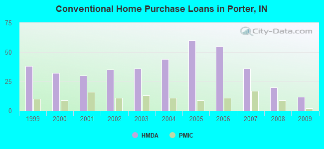
30 (See the full list of FCC Registered Amateur Radio Licenses in Porter)| Home Mortgage Disclosure Act Aggregated Statistics For Year 2009 (Based on 1 partial tract) | ||||||||||||
| A) FHA, FSA/RHS & VA Home Purchase Loans | B) Conventional Home Purchase Loans | C) Refinancings | D) Home Improvement Loans | F) Non-occupant Loans on < 5 Family Dwellings (A B C & D) | G) Loans On Manufactured Home Dwelling (A B C & D) | |||||||
|---|---|---|---|---|---|---|---|---|---|---|---|---|
| Number | Average Value | Number | Average Value | Number | Average Value | Number | Average Value | Number | Average Value | Number | Average Value | |
| LOANS ORIGINATED | 11 | $150,953 | 12 | $177,102 | 88 | $170,716 | 4 | $125,035 | 8 | $225,121 | 0 | $0 |
| APPLICATIONS APPROVED, NOT ACCEPTED | 0 | $0 | 2 | $120,740 | 9 | $158,201 | 0 | $0 | 0 | $0 | 0 | $0 |
| APPLICATIONS DENIED | 1 | $118,160 | 3 | $362,507 | 26 | $216,881 | 2 | $136,540 | 3 | $495,097 | 1 | $19,920 |
| APPLICATIONS WITHDRAWN | 0 | $0 | 0 | $0 | 15 | $168,498 | 0 | $0 | 0 | $0 | 0 | $0 |
| FILES CLOSED FOR INCOMPLETENESS | 0 | $0 | 0 | $0 | 5 | $181,918 | 1 | $138,770 | 0 | $0 | 0 | $0 |
Detailed HMDA statistics for the following Tracts: 0503.00
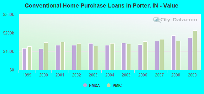
| Private Mortgage Insurance Companies Aggregated Statistics For Year 2009 (Based on 1 partial tract) | ||||
| A) Conventional Home Purchase Loans | B) Refinancings | |||
|---|---|---|---|---|
| Number | Average Value | Number | Average Value | |
| LOANS ORIGINATED | 2 | $212,970 | 3 | $215,603 |
| APPLICATIONS APPROVED, NOT ACCEPTED | 0 | $0 | 3 | $166,827 |
| APPLICATIONS DENIED | 1 | $133,620 | 2 | $207,475 |
| APPLICATIONS WITHDRAWN | 0 | $0 | 0 | $0 |
| FILES CLOSED FOR INCOMPLETENESS | 0 | $0 | 0 | $0 |
Detailed PMIC statistics for the following Tracts: 0503.00
2002 - 2017 National Fire Incident Reporting System (NFIRS) incidents
- Fire incident types reported to NFIRS in Porter, IN
- 10446.8%Structure Fires
- 5625.2%Mobile Property/Vehicle Fires
- 4721.2%Outside Fires
- 156.8%Other
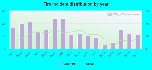 According to the data from the years 2002 - 2017 the average number of fires per year is 14. The highest number of reported fire incidents - 24 took place in 2007, and the least - 3 in 2013. The data has a dropping trend.
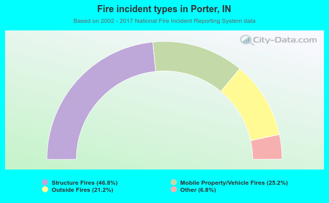 When looking into fire subcategories, the most incidents belonged to: Structure Fires (46.8%), and Mobile Property/Vehicle Fires (25.2%).
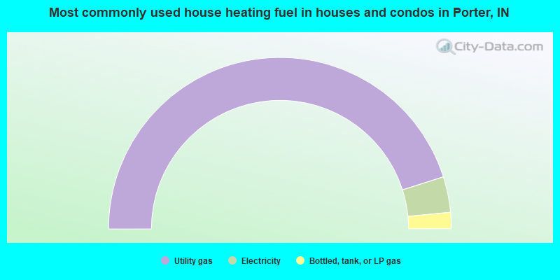
- 90.2%Utility gas
- 6.7%Electricity
- 3.1%Bottled, tank, or LP gas
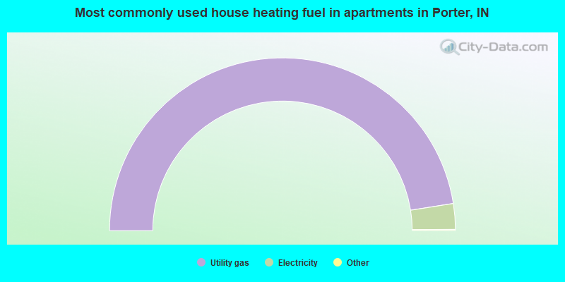
- 95.2%Utility gas
- 4.8%Electricity
Porter compared to Indiana state average:
- Unemployed percentage below state average.
- Black race population percentage significantly below state average.
- Foreign-born population percentage significantly below state average.
- Length of stay since moving in above state average.

|
|
Total of 16 patent applications in 2008-2024.