Powell, Tennessee
Submit your own pictures of this place and show them to the world
- OSM Map
- General Map
- Google Map
- MSN Map

| Males: 7,266 | |
| Females: 7,812 |
| Median resident age: | 37.0 years |
| Tennessee median age: | 35.9 years |
Zip code: 37849
| Powell: | $80,506 |
| TN: | $65,254 |
Estimated per capita income in 2022: $37,176 (it was $20,171 in 2000)
Powell CCD income, earnings, and wages data
Estimated median house or condo value in 2022: $299,018 (it was $93,700 in 2000)
| Powell: | $299,018 |
| TN: | $284,800 |
Mean prices in 2022: all housing units: $359,911; detached houses: $378,570; townhouses or other attached units: $302,801; in 2-unit structures: $187,496; in 3-to-4-unit structures: $174,348; in 5-or-more-unit structures: $303,260; mobile homes: $93,622; occupied boats, rvs, vans, etc.: $148,834
Detailed information about poverty and poor residents in Powell, TN
Compare current foreclosures in Powell, TN:
| Photo | Address | Area | Beds / Baths | Price | Details |
|---|---|---|---|---|---|

|
#1
Edgewood Dr
Powell, TN 37849
|
1,344 sq. feet
|
2 baths 3 beds |
show details | |

|
#2
Castlehill Ct
Powell, TN 37849
|
1,236 sq. feet
|
2 baths 3 beds |
show details | |

|
#3
Farmstead Ln
Powell, TN 37849
|
2,160 sq. feet
|
2 baths 3 beds |
show details | |

|
#4
Helen Ln
Powell, TN 37849
|
1,500 sq. feet
|
2 baths 3 beds |
show details | |

|
#5
Calla Ln
Powell, TN 37849
|
1,232 sq. feet
|
2 baths 3 beds |
show details | |

|
#6
Whitcomb Rd
Powell, TN 37849
|
2,312 sq. feet
|
3 baths 3 beds |
show details | |

|
#7
W Copeland Dr
Powell, TN 37849
|
1,128 sq. feet
|
1 baths 2 beds |
show details | |

|
#8
Brushy Valley Rd
Powell, TN 37849
|
1,488 sq. feet
|
1 baths 2 beds |
show details | |

|
#9
Pitch Pine Dr
Powell, TN 37849
|
1,678 sq. feet
|
2 baths 3 beds |
show details | |

|
#10
Shropshire Blvd
Powell, TN 37849
|
1,559 sq. feet
|
2 baths 3 beds |
show details |
| Photo | Address | Area | Beds / Baths | Price | Details |
|---|---|---|---|---|---|

|
#11
Brickyard Rd
Powell, TN 37849
|
1,280 sq. feet
|
1 baths 3 beds |
show details | |

|
#12
Bainbridge Way
Powell, TN 37849
|
1,754 sq. feet
|
3 baths 3 beds |
show details | |

|
#13
Macmont Cir
Powell, TN 37849
|
2,582 sq. feet
|
2 baths 3 beds |
show details | |

|
#14
Beckett Ridge Ct
Powell, TN 37849
|
1,803 sq. feet
|
2 baths 3 beds |
show details | |

|
#15
Powell Heights Rd
Powell, TN 37849
|
1,248 sq. feet
|
1 baths 3 beds |
show details | |

|
#16
Shropshire Blvd
Powell, TN 37849
|
1,874 sq. feet
|
2 baths 3 beds |
show details | |

|
#17
Windstone Blvd
Powell, TN 37849
|
1,796 sq. feet
|
2 baths 3 beds |
show details | |

|
#18
Brickyard Rd
Powell, TN 37849
|
1,280 sq. feet
|
1 baths 3 beds |
show details | |

|
#19
Intervale Way
Powell, TN 37849
|
1,000 sq. feet
|
2 baths 3 beds |
show details | |

|
#20
Hugh Willis Rd
Powell, TN 37849
|
1,188 sq. feet
|
2 baths 3 beds |
show details |
| Photo | Address | Area | Beds / Baths | Price | Details |
|---|---|---|---|---|---|

|
#21
N Dogwood Rd
Powell, TN 37849
|
1,092 sq. feet
|
1 baths - beds |
show details | |

|
#22
Cedar Cir
Powell, TN 37849
|
1,944 sq. feet
|
1 baths - beds |
show details | |

|
#23
Meadowview Ln
Powell, TN 37849
|
1,200 sq. feet
|
1 baths - beds |
show details | |

|
#24
Raccoon Valley Rd
Powell, TN 37849
|
1,196 sq. feet
|
2 baths - beds |
show details | |

|
#25
Cedar Cir
Powell, TN 37849
|
1,847 sq. feet
|
2 baths - beds |
show details | |

|
#26
Shipe Rd
Powell, TN 37849
|
1,680 sq. feet
|
1 baths - beds |
show details | |

|
#27
Foust Carney Rd
Powell, TN 37849
|
1,024 sq. feet
|
1 baths - beds |
show details | |

|
#28
Mill Park Ln
Powell, TN 37849
|
- sq. feet
|
- baths - beds |
show details | |

|
#29
Stonebridge Dr
Powell, TN 37849
|
- sq. feet
|
- baths - beds |
show details | |

|
#30
Tammy Dr # K-4
Powell, TN 37849
|
- sq. feet
|
- baths - beds |
show details |
| Photo | Address | Area | Beds / Baths | Price | Details |
|---|---|---|---|---|---|

|
#31
Greenwell Rd
Powell, TN 37849
|
1,368 sq. feet
|
- baths - beds |
show details | |

|
#32
Heiskell Rd
Powell, TN 37849
|
- sq. feet
|
- baths - beds |
show details | |

|
#33
Chrysler Ln
Powell, TN 37849
|
- sq. feet
|
- baths - beds |
show details | |

|
#34
Stanley Rd Lot 10
Powell, TN 37849
|
- sq. feet
|
- baths - beds |
show details | |

|
#35
Isaiah Ln
Powell, TN 37849
|
- sq. feet
|
- baths - beds |
show details | |

|
#36
W Brushy Valley Rd
Powell, TN 37849
|
2,016 sq. feet
|
- baths - beds |
show details | |

|
#37
Gumstand Dr
Powell, TN 37849
|
- sq. feet
|
- baths - beds |
show details | |

|
#38
Stanley Rd
Powell, TN 37849
|
- sq. feet
|
- baths - beds |
show details | |

|
#39
Sky Top Ln
Powell, TN 37849
|
- sq. feet
|
- baths - beds |
show details | |

|
#40
W Beaver Creek Dr
Powell, TN 37849
|
- sq. feet
|
- baths - beds |
show details |
| Photo | Address | Area | Beds / Baths | Price | Details |
|---|---|---|---|---|---|

|
Check over 1 million property listings on Foreclosure.com!
|
browse all offers | |||
| Photo | Address | Area | Beds / Baths | Price | Details |
|---|

- 13,09496.3%White alone
- 1741.3%Black alone
- 1290.9%Two or more races
- 910.7%Hispanic
- 760.6%Asian alone
- 260.2%American Indian alone
- 60.04%Native Hawaiian and Other
Pacific Islander alone - 40.03%Other race alone
Races in Powell detailed stats: ancestries, foreign born residents, place of birth
According to our research of Tennessee and other state lists, there were 42 registered sex offenders living in Powell, Tennessee as of April 27, 2024.
The ratio of all residents to sex offenders in Powell is 359 to 1.
The ratio of registered sex offenders to all residents in this city is near the state average.
 Recent articles from our blog. Our writers, many of them Ph.D. graduates or candidates, create easy-to-read articles on a wide variety of topics.
Current Local Time: EST time zone
Elevation: 994 feet
Land area: 22.5 square miles.
Population density: 671 people per square mile (low).

| Powell CCD: | 0.7% ($694) |
| Tennessee: | 0.8% ($715) |
Nearest city with pop. 50,000+: Knoxville, TN  (7.4 miles , pop. 173,890).
Nearest city with pop. 200,000+: Fayette, KY (139.4 miles , pop. 260,512).
Nearest city with pop. 1,000,000+: Chicago, IL (445.9 miles , pop. 2,896,016).
Nearest cities:
), ), ), ), )Latitude: 36.05 N, Longitude: 84.04 W
Area code: 865

| Here: | 2.6% |
| Tennessee: | 3.0% |
- Health care (11.5%)
- Educational services (8.3%)
- Professional, scientific, technical services (7.2%)
- Accommodation & food services (5.5%)
- Construction (5.3%)
- Public administration (4.8%)
- Administrative & support & waste management services (3.7%)
- Construction (9.4%)
- Professional, scientific, technical services (8.7%)
- Accommodation & food services (5.7%)
- Public administration (4.6%)
- Other transportation, support activities, couriers (4.0%)
- Health care (4.0%)
- Administrative & support & waste management services (4.0%)
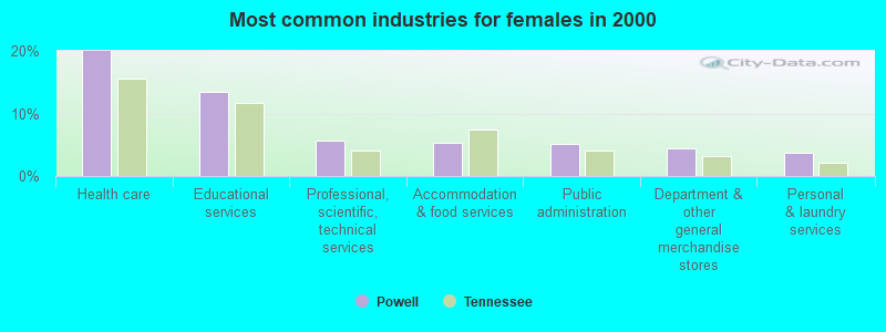
- Health care (20.0%)
- Educational services (13.5%)
- Professional, scientific, technical services (5.6%)
- Accommodation & food services (5.2%)
- Public administration (5.1%)
- Department & other general merchandise stores (4.5%)
- Personal & laundry services (3.6%)
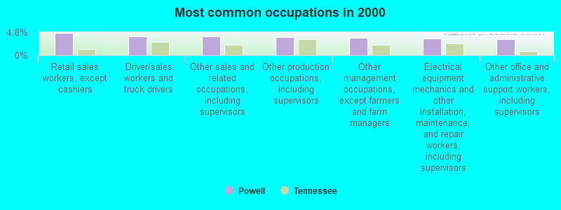
- Retail sales workers, except cashiers (4.7%)
- Driver/sales workers and truck drivers (4.0%)
- Other sales and related occupations, including supervisors (4.0%)
- Other production occupations, including supervisors (3.7%)
- Other management occupations, except farmers and farm managers (3.6%)
- Electrical equipment mechanics and other installation, maintenance, and repair workers, including supervisors (3.5%)
- Other office and administrative support workers, including supervisors (3.3%)
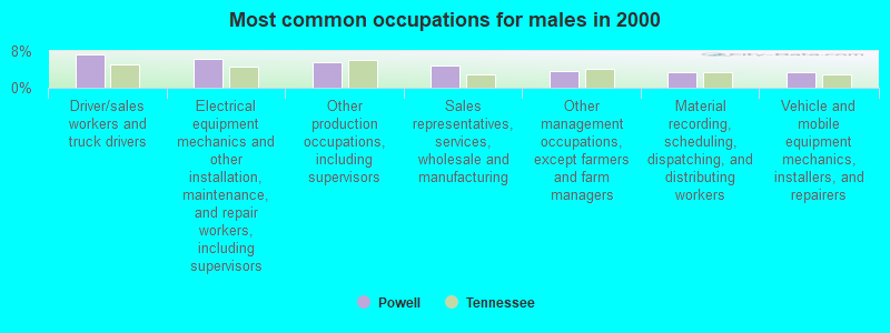
- Driver/sales workers and truck drivers (7.4%)
- Electrical equipment mechanics and other installation, maintenance, and repair workers, including supervisors (6.3%)
- Other production occupations, including supervisors (5.6%)
- Sales representatives, services, wholesale and manufacturing (5.0%)
- Other management occupations, except farmers and farm managers (3.7%)
- Material recording, scheduling, dispatching, and distributing workers (3.5%)
- Vehicle and mobile equipment mechanics, installers, and repairers (3.4%)
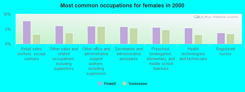
- Retail sales workers, except cashiers (7.7%)
- Other sales and related occupations, including supervisors (6.1%)
- Other office and administrative support workers, including supervisors (6.0%)
- Secretaries and administrative assistants (5.8%)
- Preschool, kindergarten, elementary, and middle school teachers (5.6%)
- Health technologists and technicians (5.4%)
- Registered nurses (3.7%)
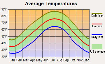
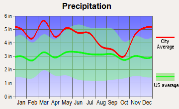
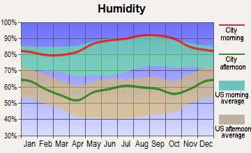
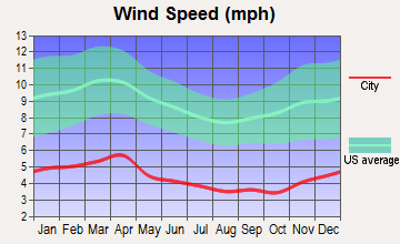
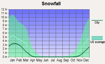
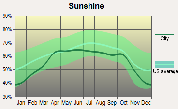
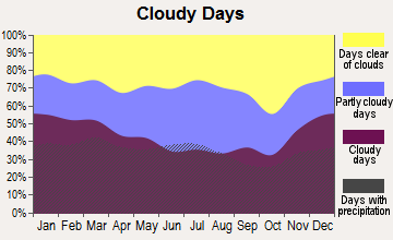
Average climate in Powell, Tennessee
Based on data reported by over 4,000 weather stations
(lower is better)
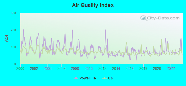
Air Quality Index (AQI) level in 2023 was 89.4. This is worse than average.
| City: | 89.4 |
| U.S.: | 72.6 |
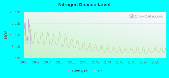
Nitrogen Dioxide (NO2) [ppb] level in 2000 was 11.8. This is significantly worse than average. Closest monitor was 1.9 miles away from the city center.
| City: | 11.8 |
| U.S.: | 5.1 |
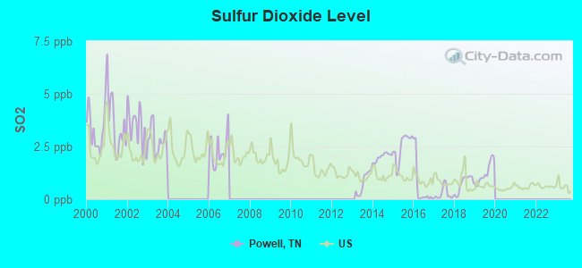
Sulfur Dioxide (SO2) [ppb] level in 2019 was 1.24. This is better than average. Closest monitor was 1.9 miles away from the city center.
| City: | 1.24 |
| U.S.: | 1.51 |
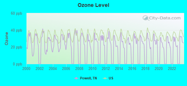
Ozone [ppb] level in 2023 was 29.4. This is about average. Closest monitor was 7.7 miles away from the city center.
| City: | 29.4 |
| U.S.: | 33.3 |
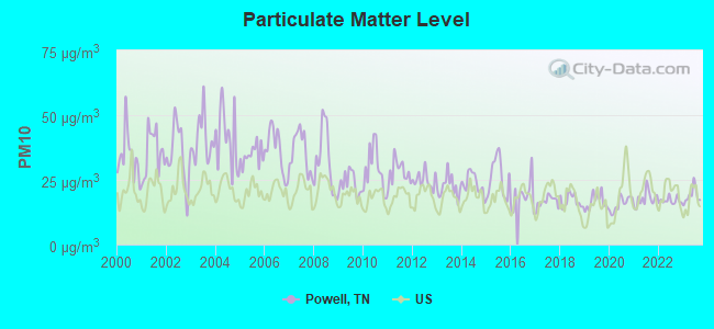
Particulate Matter (PM10) [µg/m3] level in 2023 was 18.9. This is about average. Closest monitor was 7.6 miles away from the city center.
| City: | 18.9 |
| U.S.: | 19.2 |
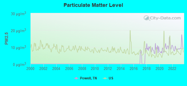
Particulate Matter (PM2.5) [µg/m3] level in 2023 was 10.6. This is worse than average. Closest monitor was 6.8 miles away from the city center.
| City: | 10.6 |
| U.S.: | 8.1 |
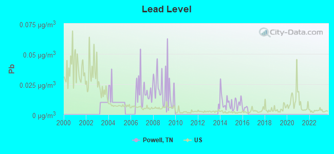
Lead (Pb) [µg/m3] level in 2015 was 0.00868. This is about average. Closest monitor was 6.5 miles away from the city center.
| City: | 0.00868 |
| U.S.: | 0.00931 |
Tornado activity:
Powell-area historical tornado activity is significantly below Tennessee state average. It is 32% smaller than the overall U.S. average.
On 2/21/1993, a category F3 (max. wind speeds 158-206 mph) tornado 5.1 miles away from the Powell place center injured 3 people and caused between $500,000 and $5,000,000 in damages.
On 2/21/1993, a category F3 tornado 20.7 miles away from the place center killed one person and injured 55 people and caused between $5000 and $50,000 in damages.
Earthquake activity:
Powell-area historical earthquake activity is significantly above Tennessee state average. It is 81% greater than the overall U.S. average.On 11/30/1973 at 07:48:41, a magnitude 4.7 (4.7 MB, 4.6 ML, Class: Light, Intensity: IV - V) earthquake occurred 17.7 miles away from the city center
On 7/27/1980 at 18:52:21, a magnitude 5.2 (5.1 MB, 4.7 MS, 5.0 UK, 5.2 UK, Class: Moderate, Intensity: VI - VII) earthquake occurred 149.3 miles away from Powell center
On 8/9/2020 at 12:07:37, a magnitude 5.1 (5.1 MW, Depth: 4.7 mi) earthquake occurred 166.7 miles away from Powell center
On 4/29/2003 at 08:59:39, a magnitude 4.9 (4.4 MB, 4.6 MW, 4.9 LG) earthquake occurred 140.2 miles away from Powell center
On 12/12/2018 at 09:14:43, a magnitude 4.4 (4.4 MW, Depth: 4.9 mi) earthquake occurred 49.4 miles away from Powell center
On 4/18/2008 at 09:36:59, a magnitude 5.4 (5.1 MB, 4.8 MS, 5.4 MW, 5.2 MW) earthquake occurred 269.4 miles away from the city center
Magnitude types: regional Lg-wave magnitude (LG), body-wave magnitude (MB), local magnitude (ML), surface-wave magnitude (MS), moment magnitude (MW)
Natural disasters:
The number of natural disasters in Knox County (13) is near the US average (15).Major Disasters (Presidential) Declared: 8
Emergencies Declared: 2
Causes of natural disasters: Floods: 9, Storms: 7, Tornadoes: 6, Winds: 3, Winter Storms: 2, Heavy Rain: 1, Hurricane: 1, Landslide: 1, Mudslide: 1, Snowfall: 1, Other: 1 (Note: some incidents may be assigned to more than one category).
Hospitals and medical centers near Powell:
- FMC POWELL (Dialysis Facility, about 3 miles away; KNOXVILLE, TN)
- OPEN ARMS CARE CORP #5 (Hospital, about 6 miles away; KNOXVILLE, TN)
- OPEN ARMS CARE CORP #4 (Hospital, about 6 miles away; KNOXVILLE, TN)
- OPEN ARMS CARE CORP #6 (Hospital, about 6 miles away; KNOXVILLE, TN)
- (CLOSED) FHC OAKWOOD (Hospital, about 6 miles away; KNOXVILLE, TN)
- PROFESSIONAL REGISTER OF NURSING SERV (Home Health Center, about 6 miles away; KNOXVILLE, TN)
- (CLOSED) HOUSECALL H H KNOXVIL (Home Health Center, about 6 miles away; KNOXVILLE, TN)
Colleges/universities with over 2000 students nearest to Powell:
- The University of Tennessee-Knoxville (about 9 miles; Knoxville, TN; Full-time enrollment: 25,483)
- Pellissippi State Community College (about 11 miles; Knoxville, TN; FT enrollment: 7,271)
- Roane State Community College (about 35 miles; Harriman, TN; FT enrollment: 4,302)
- Lincoln Memorial University (about 43 miles; Harrogate, TN; FT enrollment: 3,706)
- Walters State Community College (about 45 miles; Morristown, TN; FT enrollment: 4,359)
- University of the Cumberlands (about 49 miles; Williamsburg, KY; FT enrollment: 3,585)
- Tusculum College (about 72 miles; Greeneville, TN; FT enrollment: 2,070)
Public high school in Powell:
- POWELL HIGH SCHOOL (Students: 1,223, Location: 2136 WEST EMORY RD, Grades: 9-12)
Private high school in Powell:
Public elementary/middle schools in Powell:
- POWELL MIDDLE SCHOOL (Students: 914, Location: 3329 WEST EMORY RD, Grades: 6-8)
- POWELL ELEMENTARY (Students: 879, Location: 1711 SPRING ST, Grades: KG-5)
- COPPER RIDGE ELEMENTARY (Students: 635, Location: 2502 EAST BRUSHY VALLEY RD, Grades: KG-5)
- CLAXTON ELEMENTARY (Students: 560, Location: 2218 CLINTON HW, Grades: PK-5)
Points of interest:
Notable locations in Powell: Bell Campground (A), Jordan Siding (B), Chestnut Ridge (C), Baker Mill (D), Heiskell Volunteer Fire Department (E). Display/hide their locations on the map
Shopping Center: Powell Shopping Center (1). Display/hide its location on the map
Churches in Powell include: Sunnyview Church (A), Temple Baptist Church (B), First Baptist Church of Powell (C), Glenwood Baptist Church (D), Heiskell United Methodist Church (E), Heiskell Church (F), Bishopville Church (G), Brushy Valley Church (H), Calvary Church (I). Display/hide their locations on the map
Cemeteries: Latham Cemetery (1), Aulton Cemetery (2), Bishopville Cemetery (3), Slave Cemetery (4), Franse-Ingram Cemetery (5). Display/hide their locations on the map
Streams, rivers, and creeks: Knob Fork (A), Fowler Branch (B), Foster Branch (C), Childress Branch (D), Burnett Branch (E), Patt Branch (F), Williams Branch (G). Display/hide their locations on the map
Hotels: Comfort Inn North (323 East Emory Road) (1), Country Inn-Stes Knoxville N (7534 Conner Road) (2), Clark Motel (7130 Clinton Highway Ofc) (3), Holiday Inn Express Hotel & Suites (7520 Primetime Road) (4). Display/hide their approximate locations on the map
Birthplace of: Lee Smith (American football) - Football player.
| This place: | 2.5 people |
| Tennessee: | 2.5 people |
| This place: | 63.8% |
| Whole state: | 69.8% |
| This place: | 3.5% |
| Whole state: | 4.2% |
Likely homosexual households (counted as self-reported same-sex unmarried-partner households)
- Lesbian couples: 0.2% of all households
- Gay men: 0.4% of all households
| This place: | 6.8% |
| Whole state: | 13.5% |
| This place: | 2.2% |
| Whole state: | 5.8% |
People in group quarters in Powell in 2000:
- 394 people in college dormitories (includes college quarters off campus)
- 18 people in other noninstitutional group quarters
- 4 people in homes for the mentally retarded
Banks with branches in Powell (2011 data):
- Commercial Bank: Powell Branch at 420 East Emory Road, branch established on 1998/05/01. Info updated 2008/09/25: Bank assets: $807.9 mil, Deposits: $626.4 mil, headquarters in Harrogate, TN, positive income, Commercial Lending Specialization, 20 total offices, Holding Company: Unified Shares, Llc
- First Tennessee Bank, National Association: Powell Branch at 2121 Emory Road, branch established on 1971/12/21. Info updated 2009/09/08: Bank assets: $24,563.4 mil, Deposits: $16,402.1 mil, headquarters in Memphis, TN, positive income, Commercial Lending Specialization, 180 total offices, Holding Company: First Horizon National Corporation
- The Community Bank of East Tennessee: Powell Branch at 430 E. Emory Road, branch established on 2002/08/17. Info updated 2006/11/03: Bank assets: $58.3 mil, Deposits: $48.5 mil, headquarters in Clinton, TN, positive income, Commercial Lending Specialization, 3 total offices
- The Peoples Bank: Powell Branch at 100 West Emory Road, branch established on 2006/10/16. Info updated 2011/11/08: Bank assets: $89.9 mil, Deposits: $81.3 mil, headquarters in Ewing, VA, negative income in the last year, Commercial Lending Specialization, 5 total offices
- Home Federal Bank of Tennessee: Powell Branch at 105 East Emory Road, branch established on 1998/12/21. Info updated 2011/07/21: Bank assets: $2,047.7 mil, Deposits: $1,646.0 mil, headquarters in Knoxville, TN, positive income, 23 total offices
- Tennessee State Bank: Powell Branch at 7500 Old Clinton Pike, branch established on 2000/07/10. Info updated 2006/11/03: Bank assets: $720.6 mil, Deposits: $626.7 mil, headquarters in Pigeon Forge, TN, positive income, Commercial Lending Specialization, 16 total offices, Holding Company: Tennessee State Bancshares, Inc.
- Regions Bank: Emory Road Branch at 601 E Emory Road, branch established on 2004/10/25. Info updated 2011/02/24: Bank assets: $123,368.2 mil, Deposits: $98,301.3 mil, headquarters in Birmingham, AL, positive income, Commercial Lending Specialization, 1778 total offices, Holding Company: Regions Financial Corporation
- First Century Bank: Powell Branch at 600 East Emory, branch established on 1998/03/16. Info updated 2007/08/28: Bank assets: $255.4 mil, Deposits: $222.1 mil, headquarters in Tazewell, TN, negative income in the last year, Commercial Lending Specialization, 9 total offices, Holding Company: Claiborne Holding Company, Inc.
For population 15 years and over in Powell:
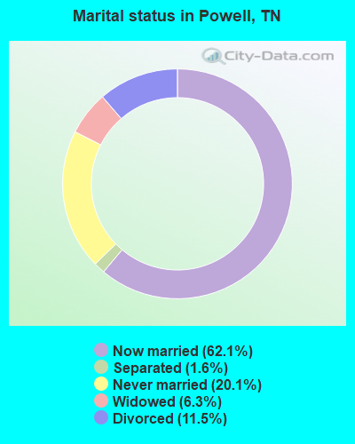
- Never married: 20.1%
- Now married: 62.1%
- Separated: 1.6%
- Widowed: 6.3%
- Divorced: 11.5%
For population 25 years and over in Powell:
- High school or higher: 80.7%
- Bachelor's degree or higher: 20.7%
- Graduate or professional degree: 7.5%
- Unemployed: 3.9%
- Mean travel time to work (commute): 22.6 minutes
| Here: | 11.9 |
| Tennessee average: | 13.3 |
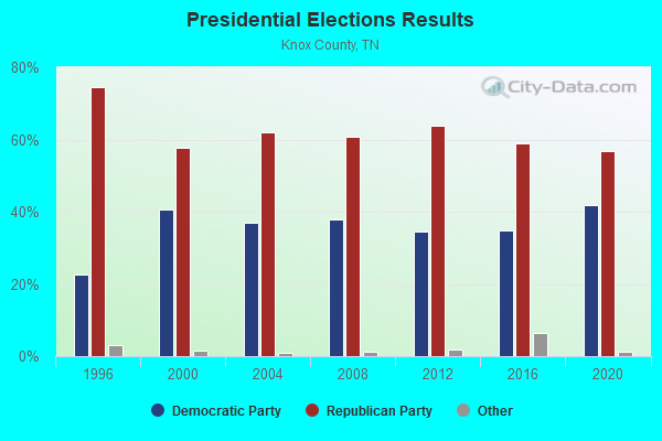
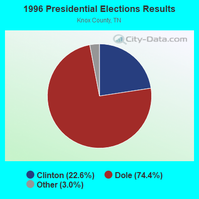
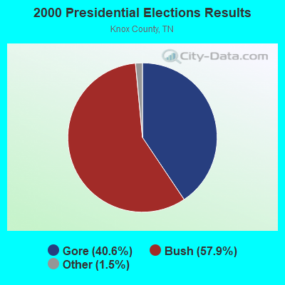
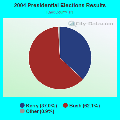
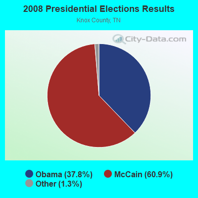
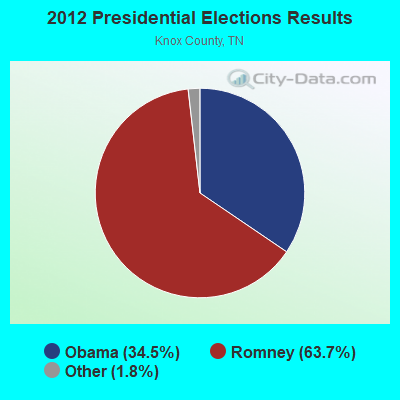
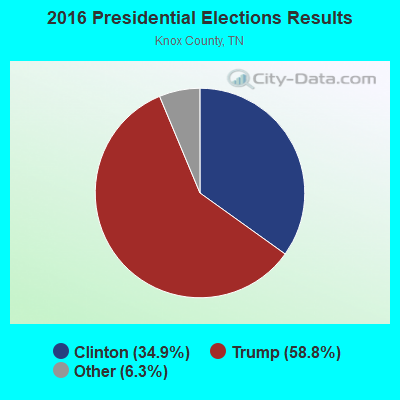
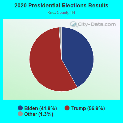
Graphs represent county-level data. Detailed 2008 Election Results
Religion statistics for Powell, TN (based on Knox County data)
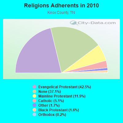
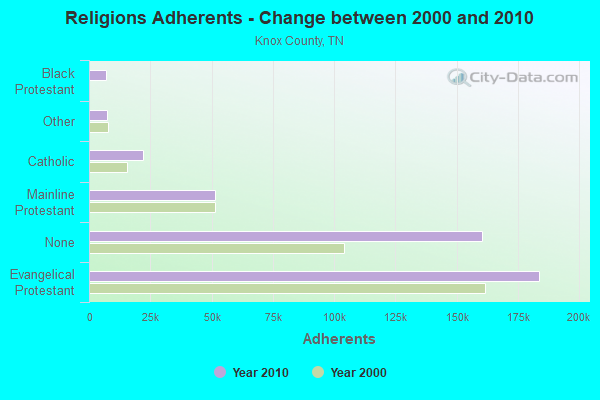
| Religion | Adherents | Congregations |
|---|---|---|
| Evangelical Protestant | 183,754 | 365 |
| Mainline Protestant | 51,345 | 116 |
| Catholic | 21,988 | 7 |
| Other | 7,178 | 34 |
| Black Protestant | 6,897 | 29 |
| Orthodox | 818 | 2 |
| None | 160,246 | - |
Food Environment Statistics:
| Knox County: | 1.75 / 10,000 pop. |
| State: | 1.99 / 10,000 pop. |
| Here: | 0.12 / 10,000 pop. |
| State: | 0.17 / 10,000 pop. |
| Knox County: | 1.37 / 10,000 pop. |
| Tennessee: | 0.65 / 10,000 pop. |
| This county: | 3.82 / 10,000 pop. |
| Tennessee: | 5.16 / 10,000 pop. |
| Knox County: | 7.39 / 10,000 pop. |
| Tennessee: | 6.56 / 10,000 pop. |
| Knox County: | 12.0% |
| Tennessee: | 11.4% |
| This county: | 27.5% |
| State: | 30.2% |
| Knox County: | 13.7% |
| Tennessee: | 13.5% |
8.03% of this county's 2021 resident taxpayers lived in other counties in 2020 ($70,106 average adjusted gross income)
| Here: | 8.03% |
| Tennessee average: | 8.49% |
0.02% of residents moved from foreign countries ($141 average AGI)
Knox County: 0.02% Tennessee average: 0.02%
Top counties from which taxpayers relocated into this county between 2020 and 2021:
| from Blount County, TN | |
| from Anderson County, TN | |
| from Sevier County, TN |
| Businesses in Powell, TN | ||||
| Name | Count | Name | Count | |
|---|---|---|---|---|
| Advance Auto Parts | 1 | Ruby Tuesday | 1 | |
| Arby's | 1 | Starbucks | 1 | |
| CVS | 1 | Steak 'n Shake | 1 | |
| Comfort Inn | 1 | Subway | 1 | |
| Dairy Queen | 1 | Super 8 | 1 | |
| Domino's Pizza | 1 | True Value | 1 | |
| FedEx | 2 | U-Haul | 2 | |
| Hardee's | 1 | UPS | 2 | |
| Holiday Inn | 1 | Waffle House | 1 | |
| Little Caesars Pizza | 1 | Walgreens | 1 | |
| McDonald's | 1 | Wendy's | 1 | |
| Pizza Hut | 1 | |||
Strongest AM radio stations in Powell:
- WQBB (1040 AM; daytime; 10 kW; POWELL, TN; Owner: JOURNAL BROADCAST CORPORATION)
- WKVL (850 AM; daytime; 50 kW; KNOXVILLE, TN; Owner: HORNE RADIO, LLC)
- WNOX (990 AM; 10 kW; KNOXVILLE, TN)
- WRJZ (620 AM; 5 kW; KNOXVILLE, TN; Owner: TENNESSEE MEDIA ASSOCIATES, INC)
- WVLZ (1180 AM; daytime; 10 kW; KNOXVILLE, TN; Owner: KIRKLAND WIRELESS BROADCASTERS, INC.)
- WATO (1290 AM; 5 kW; OAK RIDGE, TN)
- WKXV (900 AM; 1 kW; KNOXVILLE, TN; Owner: RA-TEL BROADCASTING COMPANY, INC.)
- WMEN (760 AM; daytime; 2 kW; KNOXVILLE, TN; Owner: THOMAS MOFFIT JR.)
- WITA (1490 AM; 1 kW; KNOXVILLE, TN; Owner: WITA, INC.)
- WKGN (1340 AM; 1 kW; KNOXVILLE, TN; Owner: TRIPLE S ENTERPRISES, INC.)
- WMTY (670 AM; daytime; 2 kW; FARRAGUT, TN; Owner: HORNE RADIO, LLC)
- WYSH (1380 AM; 1 kW; CLINTON, TN; Owner: CLINTON BROADCASTERS, INC.)
- WJXB (1240 AM; 1 kW; KNOXVILLE, TN; Owner: SOUTH CENTRAL COMM., CORP.)
Strongest FM radio stations in Powell:
- WYFC (95.3 FM; CLINTON, TN; Owner: BIBLE BROADCASTING NETWORK, INC.)
- WOKI-FM (100.3 FM; OAK RIDGE, TN; Owner: OAK RIDGE FM, INC.)
- WUOT (91.9 FM; KNOXVILLE, TN; Owner: UNIVERSITY OF TENNESSEE)
- WJXB-FM (97.5 FM; KNOXVILLE, TN; Owner: SOUTH CENTRAL COMMUNICATIONS CORP.)
- WYLV (89.1 FM; ALCOA, TN; Owner: FOOTHILLS BROADCASTING, INC.)
- WDVX (89.9 FM; CLINTON, TN; Owner: CUMBERLAND COMMUNITIES COMMUNI CORP.)
- WRMX-FM (106.7 FM; NORRIS, TN; Owner: SOUTH CENTRAL COMMUNICATIONS CORPORATION)
- WYIL-FM (98.7 FM; OLIVER SPRINGS, TN; Owner: CITADEL BROADCASTING COMPANY)
- WKHT (104.5 FM; KNOXVILLE, TN; Owner: JOURNAL BROADCAST CORPORATION)
- WMYU (93.1 FM; KARNS, TN; Owner: JOURNAL BROADCAST CORPORATION)
- WIMZ-FM (103.5 FM; KNOXVILLE, TN; Owner: SOUTH CENTRAL COMM., CORP.)
- WIVK-FM (107.7 FM; KNOXVILLE, TN; Owner: CITADEL BROADCASTING COMPANY)
- WWST (102.1 FM; SEVIERVILLE, TN; Owner: JOURNAL BROADCAST CORPORATION)
- WNFZ (94.3 FM; OAK RIDGE, TN; Owner: JOHN W. PIRKLE)
- WMIK-FM (92.7 FM; MIDDLESBORO, KY; Owner: GATEWAY BROADCASTING, INC.)
- WCVP-FM (95.9 FM; ROBBINSVILLE, NC; Owner: CHEROKEE BROADCASTING COMPANY, INC.)
- WSEV-FM (105.5 FM; GATLINBURG, TN; Owner: EAST TENNESSEE RADIO GROUP, L.P.)
- W237AR (95.3 FM; HAZELWOOD, ETC., NC; Owner: WESTERN NORTH CAROLINA PUBLIC RADIO)
- WTXM-FM (95.7 FM; MARYVILLE, TN; Owner: SOUTH CENTRAL COMMUNICATIONS CORP.)
- WJBZ-FM (96.3 FM; SEYMOUR, TN; Owner: SEYMOUR COMMUNICATIONS)
TV broadcast stations around Powell:
- WVLT-TV (Channel 8; KNOXVILLE, TN; Owner: WVLT LICENSEE CORP.)
- WKOP-TV (Channel 15; KNOXVILLE, TN; Owner: EAST TENNESSEE PUBLIC COMMUNICATIONS CORP.)
- WBIR-TV (Channel 10; KNOXVILLE, TN; Owner: GANNETT PACIFIC CORPORATION)
- WFEM-LP (Channel 12; HEISKELL, ETC., TN; Owner: H. EARL MARLAR)
- WATE-TV (Channel 6; KNOXVILLE, TN; Owner: WATE, G.P.)
- WTNZ (Channel 43; KNOXVILLE, TN; Owner: RAYCOM AMERICA, INC.)
- WEEE-LP (Channel 32; KNOXVILLE, TN; Owner: TIGER EYE BROADCASTING CORPORATION)
- WEZK-LP (Channel 28; KNOXVILLE, TN; Owner: SOUTH CENTRAL COMMUNICATIONS CORP.)
- W50CG (Channel 50; KNOXVILLE, TN; Owner: THREE ANGELS BROADCASTING NETWORK, INC.)
- W56CM (Channel 56; KNOXVILLE, TN; Owner: VENTANA TELEVISION, INC.)
- W46DC (Channel 46; KNOXVILLE, TN; Owner: TRINITY BROADCASTING NETWORK)
- WDTT-LP (Channel 38; LENOIR CITY, TN; Owner: WORD OF GOD FELLOWSHIP, INC.)
- W50AB (Channel 50; HIAWASSEE, GA; Owner: GEORGIA PUBLIC TELECOMMUNICATIONS COMMISSION)
- WKXE-LP (Channel 4; KNOXVILLE, TN; Owner: TIGER EYE BROADCASTING CORPORATION)
FCC Registered Cell Phone Towers:
2 (See the full list of FCC Registered Cell Phone Towers in Powell)FCC Registered Antenna Towers:
97 (See the full list of FCC Registered Antenna Towers)FCC Registered Broadcast Land Mobile Towers:
5- .8 Miles E Of Powell Tn Adj To Rr (Lat: 36.037583 Lon: -84.011583), Call Sign: WQJ888, Licensee ID: L00008014,
Assigned Frequencies: 160.950 MHz, Grant Date: 05/18/2000, Expiration Date: 07/11/2005, Cancellation Date: 06/18/2002, Registrant: Norfolk Southern Rwy Co, 99 Spring St Sw Box 123, Atlanta, GA 30303, Phone: (404) 529-1254
- 7540 Dannaher Way (Lat: 36.052194 Lon: -83.996667), Type: Mast, Structure height: 30.8 m, Overall height: 34.4 m, Call Sign: WQGH540,
Assigned Frequencies: 72.2400 MHz, Grant Date: 01/12/2017, Expiration Date: 01/18/2027, Certifier: Sonny Easley, Registrant: Primex Wireless, Inc, 965 Wells St., Lake Geneva, WI 53147, Phone: (800) 537-0464, Email:
- 7540 Dannaher Way (Lat: 36.052500 Lon: -83.998611), Type: Tower, Structure height: 37.1 m, Overall height: 45.1 m, Call Sign: WQHE460,
Assigned Frequencies: 155.340 MHz, Grant Date: 07/11/2007, Expiration Date: 01/07/2008, Cancellation Date: 03/08/2008, Certifier: Sonny Easley, Registrant: Cartwright Communication Technology, Inc., 1035 Data Lane, Knoxville, TN 37932-2570, Phone: (865) 966-1544, Fax: (865) 966-6350, Email:
- 7540 Dannaher Way (Lat: 36.052500 Lon: -83.998611), Type: Tower, Structure height: 30.5 m, Overall height: 45.1 m, Call Sign: WQHM555,
Assigned Frequencies: 155.340 MHz, Grant Date: 08/16/2017, Expiration Date: 09/10/2027, Certifier: Sonny Easley, Registrant: Cartwright Communication Technology, Inc., 1035 Data Lane, Knoxville, TN 37932-2570, Phone: (865) 966-1544, Fax: (865) 966-6350, Email:
- Lat: 36.037083 Lon: -84.028972, Call Sign: WRUE940,
Assigned Frequencies: 456.712 MHz, Grant Date: 08/19/2022, Expiration Date: 08/19/2032, Certifier: Tanna Garrett, Registrant: Two Way Radio Gear, 3245 Okeechobee Rd, Port Saint Lucie, FL 34987, Phone: (800) 984-1534, Email:
FCC Registered Microwave Towers:
19 (See the full list of FCC Registered Microwave Towers in this town)FCC Registered Amateur Radio Licenses:
235 (See the full list of FCC Registered Amateur Radio Licenses in Powell)FAA Registered Aircraft:
19 (See the full list of FAA Registered Aircraft in Powell)2002 - 2018 National Fire Incident Reporting System (NFIRS) incidents
- Fire incident types reported to NFIRS in Powell, TN
- 29541.0%Structure Fires
- 28139.1%Outside Fires
- 12517.4%Mobile Property/Vehicle Fires
- 182.5%Other
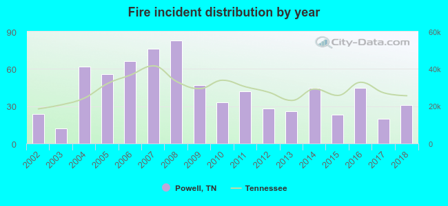 Based on the data from the years 2002 - 2018 the average number of fires per year is 42. The highest number of fires - 83 took place in 2008, and the least - 12 in 2003. The data has a rising trend.
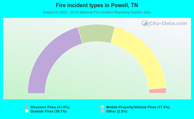 When looking into fire subcategories, the most reports belonged to: Structure Fires (41.0%), and Outside Fires (39.1%).
Fire-safe hotels and motels in Powell, Tennessee:
- Super 8 Powell, 323 E Emory Rd, Powell, Tennessee 37849 , Phone: (865) 938-5501, Fax: (865) 938-5504
- Country Inn & Suites By Carlson, 7534 Conner Rd, Powell, Tennessee 37849 , Phone: (865) 947-7500, Fax: (865) 947-5444
- Comfort Inn, 7585 Barnett Way, Powell, Tennessee 37849 , Phone: (865) 938-5500, Fax: (865) 938-5508
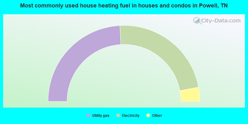
- 48.3%Utility gas
- 45.7%Electricity
- 3.9%Bottled, tank, or LP gas
- 1.2%Wood
- 0.9%Fuel oil, kerosene, etc.
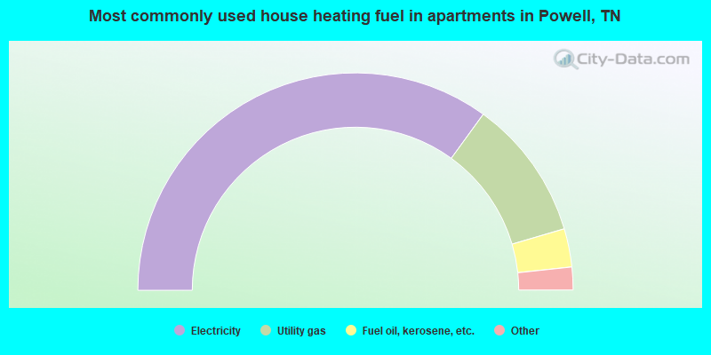
- 69.9%Electricity
- 20.9%Utility gas
- 5.7%Fuel oil, kerosene, etc.
- 2.5%Bottled, tank, or LP gas
- 0.9%Wood
Powell compared to Tennessee state average:
- Unemployed percentage significantly below state average.
- Black race population percentage significantly below state average.
- Hispanic race population percentage significantly below state average.
- Foreign-born population percentage significantly below state average.
- Renting percentage significantly below state average.
- Length of stay since moving in significantly above state average.
- Number of rooms per house significantly below state average.
- House age significantly below state average.
Powell on our top lists:
- #6 on the list of "Top 101 cities with largest percentage of males in occupations: waiters and waitresses (population 5,000+)"
- #14 on the list of "Top 101 cities with largest percentage of females in occupations: retail sales workers except cashiers (population 5,000+)"
- #23 on the list of "Top 101 cities with largest percentage of males in industries: professional and commercial equipment and supplies merchant wholesalers (population 5,000+)"
- #24 on the list of "Top 101 cities with largest percentage of females in industries: repair and maintenance (population 5,000+)"
- #29 on the list of "Top 101 cities with largest percentage of males in occupations: cashiers (population 5,000+)"
- #39 on the list of "Top 101 cities with largest percentage of females in occupations: occupational and physical therapist assistants and aides (population 5,000+)"
- #51 on the list of "Top 101 cities with largest percentage of males in industries: rail transportation (population 5,000+)"
- #52 on the list of "Top 101 cities with largest percentage of males in industries: vending machine operators (population 5,000+)"
- #53 on the list of "Top 101 cities with largest percentage of females in industries: clothing and accessories, including shoe, stores (population 5,000+)"
- #57 on the list of "Top 101 cities with largest percentage of females in occupations: therapists (population 5,000+)"
- #59 on the list of "Top 101 cities with largest percentage of females in occupations: personal appearance workers (population 5,000+)"
- #61 on the list of "Top 101 cities with largest percentage of females in industries: apparel (population 5,000+)"
- #63 on the list of "Top 101 cities with largest percentage of females in industries: office supplies and stationery stores (population 5,000+)"
- #65 on the list of "Top 101 cities with largest percentage of males in industries: other transportation, and support activities, and couriers (population 5,000+)"
- #68 on the list of "Top 101 cities with largest percentage of males in industries: apparel (population 5,000+)"
- #71 on the list of "Top 101 cities with largest percentage of males in industries: lumber and other construction materials merchant wholesalers (population 5,000+)"
- #81 on the list of "Top 101 cities with largest percentage of females in industries: vending machine operators (population 5,000+)"
- #83 on the list of "Top 101 cities with largest percentage of females in industries: motor vehicle and parts dealers (population 5,000+)"
- #91 on the list of "Top 101 cities with largest percentage of females in industries: personal and laundry services (population 5,000+)"
- #95 on the list of "Top 101 cities with largest percentage of males in industries: metals and minerals, except petroleum, merchant wholesalers (population 5,000+)"
- #46 (37849) on the list of "Top 101 zip codes with the largest percentage of Scotch-Irish first ancestries (pop 5,000+)"
- #3 on the list of "Top 101 counties with the lowest percentage of residents that drank alcohol in the past 30 days"
- #30 on the list of "Top 101 counties with the most Evangelical Protestant adherents"
- #49 on the list of "Top 101 counties with the worst general health status score of residents (1-5), 3 years of data"
- #51 on the list of "Top 101 counties with the most Evangelical Protestant congregations"
- #66 on the list of "Top 101 counties with the highest percentage of residents that keep firearms around their homes"

|
|
Total of 103 patent applications in 2008-2024.