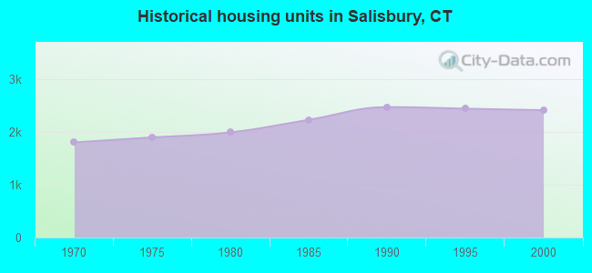
Salisbury, Connecticut

Submit your own pictures of this town and show them to the world
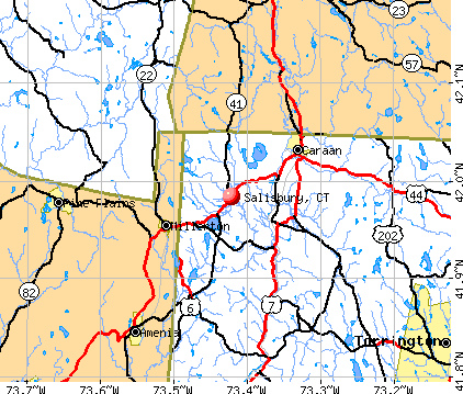
- OSM Map
- General Map
- Google Map
- MSN Map
Population change since 2000: -5.9%
 |
| Males: 1,773 | |
| Females: 1,968 |
| Median resident age: | 52.7 years |
| Connecticut median age: | 39.2 years |
Zip codes: 06068.
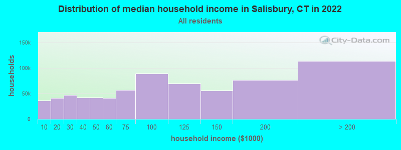
| Salisbury: | $86,980 |
| CT: | $88,429 |
Estimated per capita income in 2022: $69,487 (it was $38,752 in 2000)
Salisbury town income, earnings, and wages data
Estimated median house or condo value in 2022: $533,123 (it was $246,600 in 2000)
| Salisbury: | $533,123 |
| CT: | $347,200 |
Mean prices in 2022: all housing units: $429,743; detached houses: $455,293; townhouses or other attached units: $232,674; in 2-unit structures: $242,050; in 3-to-4-unit structures: $229,634; in 5-or-more-unit structures: $182,162; mobile homes: $243,504; occupied boats, rvs, vans, etc.: $127,144
Detailed information about poverty and poor residents in Salisbury, CT
Compare current foreclosures near Salisbury, CT:
| Photo | Address | Area | Beds / Baths | Price | Details |
|---|---|---|---|---|---|

|
#1
State Route 22
Copake Falls, NY 12517
|
1,200 sq. feet
|
1 baths 2 beds |
$459,900
|
show details |

|
#2
Litchfield Rd
Norfolk, CT 06058
|
3,678 sq. feet
|
3 baths 6 beds |
$665,500
|
show details |

|
#3
Alum Hill Road
Sheffield, MA 01257
|
1,040 sq. feet
|
2 baths 3 beds |
show details | |

|
#4
Route 22
Wassaic, NY 12592
|
1,904 sq. feet
|
2 baths 4 beds |
show details | |

|
#5
Route 23
Hillsdale, NY 12529
|
2,762 sq. feet
|
2 baths 4 beds |
show details | |

|
#6
Hillside Village Rd
Pine Plains, NY 12567
|
868 sq. feet
|
2 baths 3 beds |
show details | |

|
#7
County Rd
Great Barrington, MA 01230
|
1,576 sq. feet
|
1 baths 4 beds |
show details | |

|
#8
Route 82
Stanfordville, NY 12581
|
1,862 sq. feet
|
1 baths 3 beds |
show details | |

|
#9
County Route 7
Ancram, NY 12502
|
1,182 sq. feet
|
4 baths 7 beds |
show details | |

|
#10
Route 44
Amenia, NY 12501
|
2,016 sq. feet
|
2 baths 3 beds |
show details |
| Photo | Address | Area | Beds / Baths | Price | Details |
|---|---|---|---|---|---|

|
#11
Taft Rd
Copake, NY 12516
|
1,128 sq. feet
|
1 baths 2 beds |
show details | |

|
#12
Sheldon Dr
Pine Plains, NY 12567
|
2,688 sq. feet
|
2 baths 3 beds |
show details | |

|
#13
Main St
Sheffield, MA 01257
|
3,683 sq. feet
|
5 baths 6 beds |
show details | |

|
#14
Route 22
Amenia, NY 12501
|
1,941 sq. feet
|
2 baths 3 beds |
show details | |

|
#15
S Sandisfield Rd
Great Barrington, MA 01230
|
1,983 sq. feet
|
2 baths 2 beds |
show details | |

|
#16
S Undermountain Rd
Sheffield, MA 01257
|
1,713 sq. feet
|
2 baths 3 beds |
show details | |

|
#17
Amenia Rd
Sharon, CT 06069
|
3,126 sq. feet
|
4 baths 4 beds |
show details | |

|
#18
Layton Rd
Stanfordville, NY 12581
|
1,660 sq. feet
|
1 baths 3 beds |
show details | |

|
#19
Route 23
Hillsdale, NY 12529
|
- sq. feet
|
- baths - beds |
show details | |

|
#20
Birch Hill Rd
Craryville, NY 12521
|
- sq. feet
|
- baths - beds |
show details |
| Photo | Address | Area | Beds / Baths | Price | Details |
|---|---|---|---|---|---|

|
#21
Ironwood Ln
Wassaic, NY 12592
|
- sq. feet
|
- baths - beds |
show details | |

|
#22
Crescent Dr
Hillsdale, NY 12529
|
- sq. feet
|
- baths - beds |
show details | |

|
#23
Creamery Rd
Stanfordville, NY 12581
|
- sq. feet
|
- baths - beds |
show details | |

|
#24
Blunt Rd
Great Barrington, MA 01230
|
- sq. feet
|
- baths - beds |
show details | |

|
#25
Christian Hill Rd Apt 32
Great Barrington, MA 01230
|
- sq. feet
|
- baths - beds |
show details | |

|
#26
S Amenia Rd
Wassaic, NY 12592
|
- sq. feet
|
- baths - beds |
show details | |

|
#27
Main St
Millerton, NY 12546
|
- sq. feet
|
- baths - beds |
show details | |

|
#28
Ryan Rd
Pine Plains, NY 12567
|
- sq. feet
|
- baths - beds |
show details | |

|
#29
Viewmont Rd
Copake, NY 12516
|
- sq. feet
|
- baths - beds |
show details | |

|
#30
Amenia Union Rd # 2
Amenia, NY 12501
|
- sq. feet
|
- baths - beds |
show details |
| Photo | Address | Area | Beds / Baths | Price | Details |
|---|---|---|---|---|---|

|
#31
Old Post Rd 3, Lot 10
Millerton, NY 12546
|
- sq. feet
|
- baths - beds |
show details | |

|
#32
Church St
Pine Plains, NY 12567
|
- sq. feet
|
- baths - beds |
show details | |

|
#33
Rhoades And Bailey Rd
Mill River, MA 01244
|
- sq. feet
|
- baths - beds |
show details | |

|
#34
Route 22
Amenia, NY 12501
|
- sq. feet
|
- baths - beds |
show details | |

|
#35
Root Ln
Sheffield, MA 01257
|
- sq. feet
|
- baths - beds |
show details | |

|
#36
Route 22
Amenia, NY 12501
|
- sq. feet
|
- baths - beds |
show details | |

|
#37
Norfolk Rd
East Canaan, CT 06024
|
- sq. feet
|
- baths - beds |
show details | |

|
#38
Alum Hill Rd
Sheffield, MA 01257
|
- sq. feet
|
- baths - beds |
show details | |

|
#39
Hewins St
Ashley Falls, MA 01222
|
- sq. feet
|
- baths - beds |
show details | |

|
#40
West Rd
Southfield, MA 01259
|
- sq. feet
|
- baths - beds |
show details |
| Photo | Address | Area | Beds / Baths | Price | Details |
|---|---|---|---|---|---|

|
#41
Great Hill Rd
Litchfield, CT 06759
|
- sq. feet
|
- baths - beds |
show details | |

|
Check over 1 million property listings on Foreclosure.com!
|
browse all offers | |||

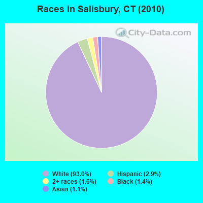
- 3,47993.0%White alone
- 1072.9%Hispanic
- 581.6%Two or more races
- 521.4%Black alone
- 411.1%Asian alone
- 30.08%Other race alone
- 10.03%American Indian alone
Races in Salisbury detailed stats: ancestries, foreign born residents, place of birth
According to our research of Connecticut and other state lists, there was 1 registered sex offender living in Salisbury, Connecticut as of April 28, 2024.
The ratio of all residents to sex offenders in Salisbury is 3,741 to 1.
The ratio of registered sex offenders to all residents in this city is much lower than the state average.
 Recent articles from our blog. Our writers, many of them Ph.D. graduates or candidates, create easy-to-read articles on a wide variety of topics.

 | 2024 Connecticut Town Tournament VI (Celebrating the 10-Year Anniversary & Dazzleman's Memorial) (746 replies) |
| Connecticut TOWN TOURNAMENT V (2022) (831 replies) |
| Connecticut TOWN TOURNAMENT IV (2020) (849 replies) |
| Moving from California to Connecticut. Where should we live? (48 replies) |
| Is CT the best fit? (16 replies) |
| Connecticut TOWN TOURNAMENT II (2016) (401 replies) |
Latest news from Salisbury, CT collected exclusively by city-data.com from local newspapers, TV, and radio stations
Salisbury, CT City Guides:
Ancestries: Irish (23.4%), English (20.2%), German (14.3%), Italian (11.5%), French (6.2%), Polish (6.2%).
Current Local Time: EST time zone
Incorporated on 10/1741
Elevation: 688 feet
Land area: 57.3 square miles.
Population density: 65 people per square mile (very low).
198 residents are foreign born (2.3% Europe, 2.0% Latin America).
| This town: | 5.0% |
| Connecticut: | 10.9% |
| Salisbury town: | 1.0% ($2,449) |
| Connecticut: | 1.8% ($2,961) |
Nearest city with pop. 50,000+: Bristol, CT  (32.5 miles , pop. 60,062).
Nearest city with pop. 200,000+: Bronx, NY (81.6 miles , pop. 1,332,650).
Nearest cities:
), ), ), ), ), Latitude: 41.98 N, Longitude: 73.42 W
Area code commonly used in this area: 860

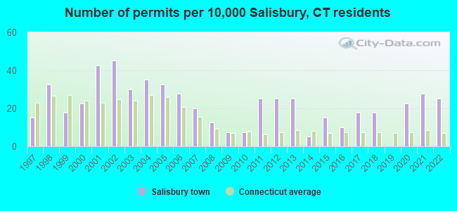
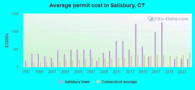
Single-family new house construction building permits:
- 2022: 10 buildings, average cost: $248,200
- 2021: 11 buildings, average cost: $248,200
- 2020: 9 buildings, average cost: $248,200
- 2018: 7 buildings, average cost: $1,259,900
- 2017: 7 buildings, average cost: $989,000
- 2016: 4 buildings, average cost: $302,000
- 2015: 6 buildings, average cost: $594,300
- 2014: 2 buildings, average cost: $1,231,700
- 2013: 10 buildings, average cost: $497,400
- 2012: 10 buildings, average cost: $741,400
- 2011: 10 buildings, average cost: $741,400
- 2010: 3 buildings, average cost: $466,700
- 2009: 3 buildings, average cost: $410,000
- 2008: 5 buildings, average cost: $181,800
- 2007: 8 buildings, average cost: $494,100
- 2006: 11 buildings, average cost: $494,100
- 2005: 13 buildings, average cost: $494,100
- 2004: 14 buildings, average cost: $494,100
- 2003: 12 buildings, average cost: $364,300
- 2002: 18 buildings, average cost: $479,500
- 2001: 17 buildings, average cost: $268,600
- 2000: 9 buildings, average cost: $325,000
- 1999: 7 buildings, average cost: $392,900
- 1998: 13 buildings, average cost: $382,400
- 1997: 6 buildings, average cost: $183,800
| Here: | 2.7% |
| Connecticut: | 3.9% |
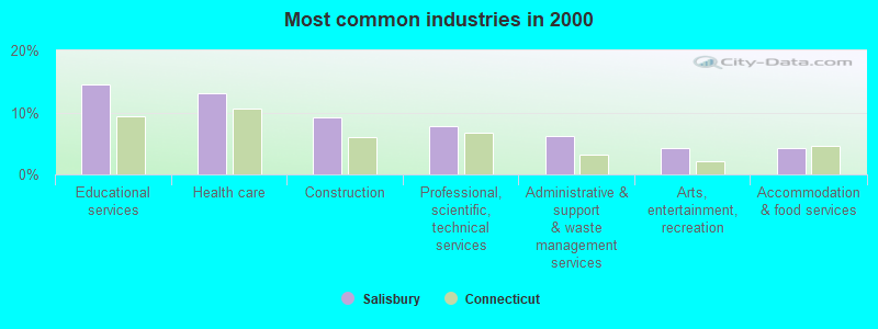
- Educational services (14.5%)
- Health care (13.0%)
- Construction (9.2%)
- Professional, scientific, technical services (7.8%)
- Administrative & support & waste management services (6.1%)
- Arts, entertainment, recreation (4.3%)
- Accommodation & food services (4.2%)
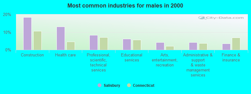
- Construction (18.4%)
- Health care (13.0%)
- Professional, scientific, technical services (8.2%)
- Educational services (6.3%)
- Arts, entertainment, recreation (4.3%)
- Administrative & support & waste management services (4.2%)
- Finance & insurance (3.5%)
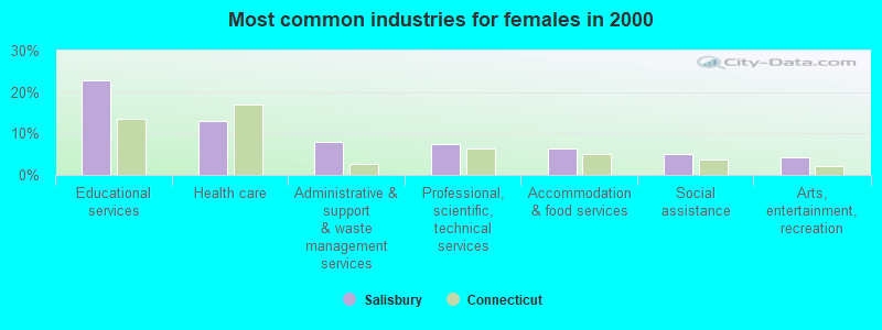
- Educational services (22.8%)
- Health care (13.0%)
- Administrative & support & waste management services (8.1%)
- Professional, scientific, technical services (7.4%)
- Accommodation & food services (6.3%)
- Social assistance (5.1%)
- Arts, entertainment, recreation (4.3%)
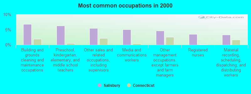
- Building and grounds cleaning and maintenance occupations (6.8%)
- Preschool, kindergarten, elementary, and middle school teachers (6.3%)
- Other sales and related occupations, including supervisors (5.5%)
- Media and communications workers (5.1%)
- Other management occupations, except farmers and farm managers (4.7%)
- Registered nurses (3.5%)
- Material recording, scheduling, dispatching, and distributing workers (3.3%)
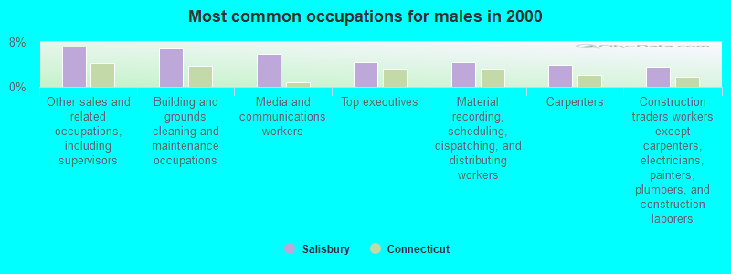
- Other sales and related occupations, including supervisors (7.2%)
- Building and grounds cleaning and maintenance occupations (6.8%)
- Media and communications workers (5.8%)
- Top executives (4.4%)
- Material recording, scheduling, dispatching, and distributing workers (4.4%)
- Carpenters (3.9%)
- Construction traders workers except carpenters, electricians, painters, plumbers, and construction laborers (3.7%)
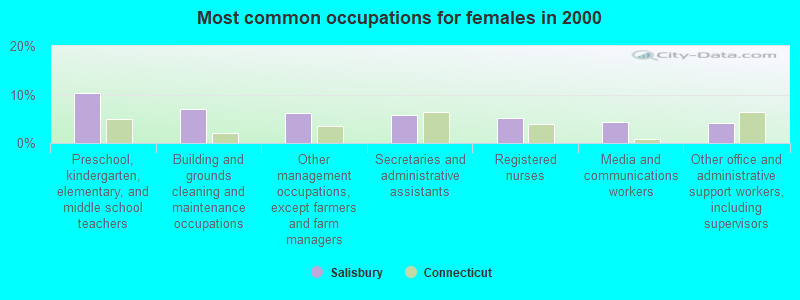
- Preschool, kindergarten, elementary, and middle school teachers (10.4%)
- Building and grounds cleaning and maintenance occupations (6.9%)
- Other management occupations, except farmers and farm managers (6.2%)
- Secretaries and administrative assistants (5.8%)
- Registered nurses (5.1%)
- Media and communications workers (4.3%)
- Other office and administrative support workers, including supervisors (4.2%)
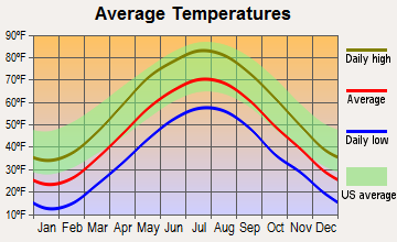
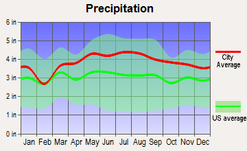
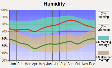
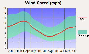
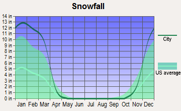
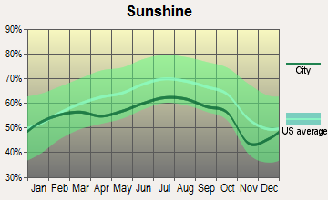
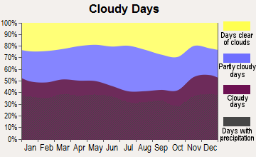
Average climate in Salisbury, Connecticut
Based on data reported by over 4,000 weather stations
(lower is better)
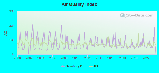
Air Quality Index (AQI) level in 2023 was 79.4. This is about average.
| City: | 79.4 |
| U.S.: | 72.6 |
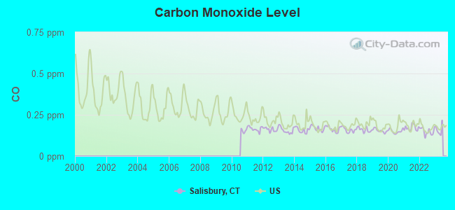
Carbon Monoxide (CO) [ppm] level in 2022 was 0.149. This is significantly better than average. Closest monitor was 10.6 miles away from the city center.
| City: | 0.149 |
| U.S.: | 0.251 |
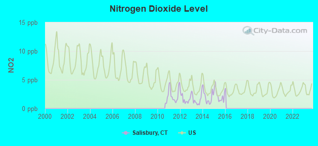
Nitrogen Dioxide (NO2) [ppb] level in 2015 was 2.27. This is significantly better than average. Closest monitor was 10.6 miles away from the city center.
| City: | 2.27 |
| U.S.: | 5.11 |
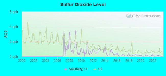
Sulfur Dioxide (SO2) [ppb] level in 2022 was 0.109. This is significantly better than average. Closest monitor was 10.6 miles away from the city center.
| City: | 0.109 |
| U.S.: | 1.515 |
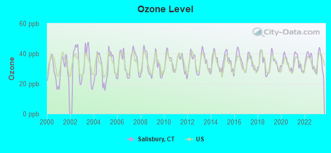
Ozone [ppb] level in 2023 was 34.6. This is about average. Closest monitor was 12.6 miles away from the city center.
| City: | 34.6 |
| U.S.: | 33.3 |
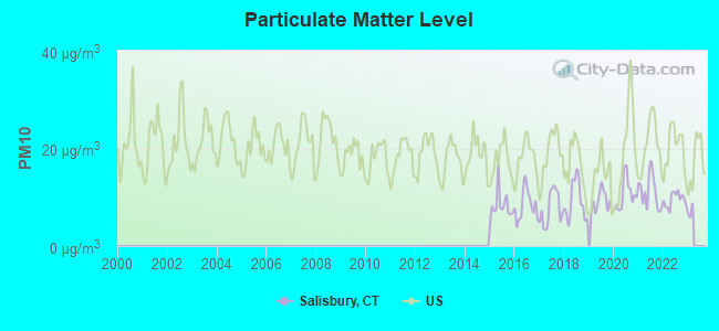
Particulate Matter (PM10) [µg/m3] level in 2022 was 9.49. This is significantly better than average. Closest monitor was 12.6 miles away from the city center.
| City: | 9.49 |
| U.S.: | 19.21 |
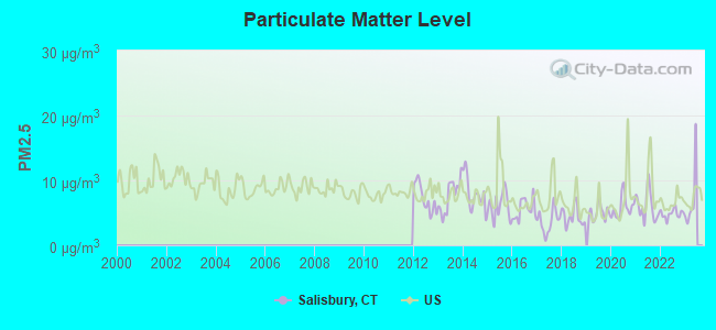
Particulate Matter (PM2.5) [µg/m3] level in 2022 was 4.86. This is significantly better than average. Closest monitor was 12.6 miles away from the city center.
| City: | 4.86 |
| U.S.: | 8.11 |
Tornado activity:
Salisbury-area historical tornado activity is slightly above Connecticut state average. It is 19% smaller than the overall U.S. average.
On 5/29/1995, a category F4 (max. wind speeds 207-260 mph) tornado 15.4 miles away from the Salisbury town center killed 3 people and injured 24 people and caused between $5,000,000 and $50,000,000 in damages.
On 8/28/1973, a category F4 tornado 20.4 miles away from the town center killed 4 people and injured 36 people and caused between $5,000,000 and $50,000,000 in damages.
Earthquake activity:
Salisbury-area historical earthquake activity is significantly above Connecticut state average. It is 69% smaller than the overall U.S. average.On 10/7/1983 at 10:18:46, a magnitude 5.3 (5.1 MB, 5.3 LG, 5.1 ML, Class: Moderate, Intensity: VI - VII) earthquake occurred 144.3 miles away from the city center
On 4/20/2002 at 10:50:47, a magnitude 5.3 (5.3 ML, Depth: 3.0 mi) earthquake occurred 175.9 miles away from the city center
On 4/20/2002 at 10:50:47, a magnitude 5.2 (5.2 MB, 4.2 MS, 5.2 MW, 5.0 MW) earthquake occurred 174.2 miles away from Salisbury center
On 1/19/1982 at 00:14:42, a magnitude 4.7 (4.5 MB, 4.7 MD, 4.5 LG, Class: Light, Intensity: IV - V) earthquake occurred 140.3 miles away from the city center
On 8/23/2011 at 17:51:04, a magnitude 5.8 (5.8 MW, Depth: 3.7 mi) earthquake occurred 369.2 miles away from the city center
On 10/16/2012 at 23:12:25, a magnitude 4.7 (4.7 ML, Depth: 10.0 mi) earthquake occurred 179.7 miles away from Salisbury center
Magnitude types: regional Lg-wave magnitude (LG), body-wave magnitude (MB), duration magnitude (MD), local magnitude (ML), surface-wave magnitude (MS), moment magnitude (MW)
Natural disasters:
The number of natural disasters in Litchfield County (23) is greater than the US average (15).Major Disasters (Presidential) Declared: 13
Emergencies Declared: 10
Causes of natural disasters: Storms: 7, Hurricanes: 5, Floods: 4, Snowstorms: 4, Blizzards: 3, Snows: 2, Tropical Storms: 2, Winter Storms: 2, Snowfall: 1, Tornado: 1, Wind: 1 (Note: some incidents may be assigned to more than one category).
Hospitals and medical centers in Salisbury:
Colleges/universities with over 2000 students nearest to Salisbury:
- Bard College (about 25 miles; Annandale-On-Hudson, NY; Full-time enrollment: 3,137)
- Dutchess Community College (about 31 miles; Poughkeepsie, NY; FT enrollment: 6,554)
- Culinary Institute of America (about 31 miles; Hyde Park, NY; FT enrollment: 3,869)
- Vassar College (about 32 miles; Poughkeepsie, NY; FT enrollment: 2,469)
- Marist College (about 32 miles; Poughkeepsie, NY; FT enrollment: 5,536)
- Tunxis Community College (about 34 miles; Farmington, CT; FT enrollment: 2,787)
- Westfield State University (about 35 miles; Westfield, MA; FT enrollment: 5,548)
Points of interest:
Notable locations in Salisbury: Camp Sloane (A), State Line (B), Camp Wangum (C), Holley Williams House Museum (D), Edsel Ford Memorial Library (E), Lime Rock Park Ambulance (F), Salisbury Volunteer Ambulance Service (G), Salisbury Fire Marshal's Office (H), Lakeville Hose Company (I). Display/hide their locations on the map
Churches in Salisbury include: Trinity Church Lime Rock (A), Congregational Church of Christ (B), Lakeview United Methodist Church (C). Display/hide their locations on the map
Cemetery: Dutcher Bridge Cemetery (1). Display/hide its location on the map
Lakes and reservoirs: Taylor Pond (A), Twin Lakes (B), Washinee Lake (C), Washining Lake (D), Wononpakook Lake (E), Wononskopomuc Lake (F), Fisher Pond (G), Ore Hill Pond (H). Display/hide their locations on the map
Streams, rivers, and creeks: McDuffee Brook (A), Monument Brook (B), Moore Brook (C), Ore Hill Brook (D), Pettee Brook (E), Spruce Swamp Creek (F), Wachocastinook Creek (G), Ball Brook (H), Beeslick Brook (I). Display/hide their locations on the map
Parks in Salisbury include: Mount Riga State Park (1), Cobble Park (2), Edith Scoville Memorial Sanctuary (3), Lime Rock Historic District (4), Lime Rock Park (5). Display/hide their locations on the map
Hotels: White Hart (15 Under Mountain Road) (1), Four Seasons Foods (349 A Main Street) (2). Display/hide their approximate locations on the map
Birthplace of: Martin W. Bates - Lawyer and politician, Nathaniel Chipman - Federal judge, Jonathan Scoville - Politician, Josiah S. Johnston - Politician.
Drinking water stations with addresses in Salisbury and their reported violations in the past:
SALISBURY SCHOOL (Population served: 520, Groundwater):Past monitoring violations:
- Monitoring and Reporting (DBP) - Between JAN-2013 and MAR-2013, Contaminant: Chlorine. Follow-up actions: St Compliance achieved (MAY-06-2013), St Violation/Reminder Notice (JUL-11-2013)
- Monitoring and Reporting (DBP) - Between APR-2012 and JUN-2012, Contaminant: Chlorine. Follow-up actions: St Compliance achieved (AUG-07-2012), St Violation/Reminder Notice (OCT-10-2012)
- Monitoring and Reporting (DBP) - Between JAN-2011 and DEC-2011, Contaminant: TTHM. Follow-up actions: St Violation/Reminder Notice (MAR-21-2012), St Compliance achieved (APR-03-2012)
- Follow-up Or Routine LCR Tap M/R - In OCT-01-2001, Contaminant: Lead and Copper Rule. Follow-up actions: St Public Notif requested (NOV-22-2000), St Violation/Reminder Notice (NOV-22-2000), St Public Notif received (DEC-12-2000), St BCA signed (DEC-14-2000), St AO (w/penalty) issued (NOV-27-2001), St Public Notif received (DEC-14-2001)
- 2 routine major monitoring violations
| This town: | 2.1 people |
| Connecticut: | 2.5 people |
| This town: | 58.2% |
| Whole state: | 66.3% |
| This town: | 7.0% |
| Whole state: | 6.6% |
Likely homosexual households (counted as self-reported same-sex unmarried-partner households)
- Lesbian couples: 0.5% of all households
- Gay men: 1.2% of all households
| This town: | 7.8% |
| Whole state: | 7.9% |
| This town: | 4.8% |
| Whole state: | 3.9% |
People in group quarters in Salisbury in 2010:
- 109 people in college/university student housing
- 102 people in nursing facilities/skilled-nursing facilities
- 5 people in group homes for juveniles (non-correctional)
- 3 people in workers' group living quarters and job corps centers
63 people in other nonhousehold living situations in 2000
Banks with branches in Salisbury (2011 data):
- Salisbury Bank and Trust Company: Salisbury Branch at 18 Main Street, branch established on 1963/04/29. Info updated 2010/09/29: Bank assets: $608.2 mil, Deposits: $480.4 mil, headquarters in Lakeville, CT, positive income, 8 total offices, Holding Company: Salisbury Bancorp, Inc.
- The National Iron Bank: at 195 Main Street, branch established on 1847/08/17. Info updated 2006/11/03: Bank assets: $101.4 mil, Deposits: $91.6 mil, local headquarters, positive income, Mortgage Lending Specialization, 4 total offices, Holding Company: Iron Bancshares, Inc.
For population 15 years and over in Salisbury:
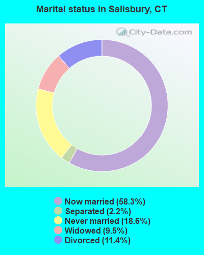
- Never married: 18.6%
- Now married: 58.3%
- Separated: 2.2%
- Widowed: 9.5%
- Divorced: 11.4%
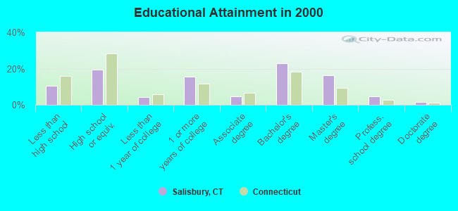
For population 25 years and over in Salisbury:
- High school or higher: 89.4%
- Bachelor's degree or higher: 45.3%
- Graduate or professional degree: 22.4%
- Unemployed: 4.9%
- Mean travel time to work (commute): 24.2 minutes
| Here: | 11.3 |
| Connecticut average: | 12.8 |
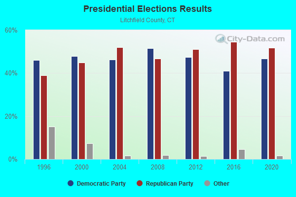
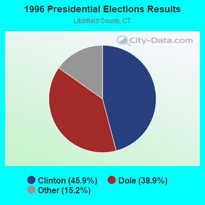
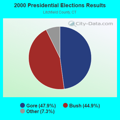
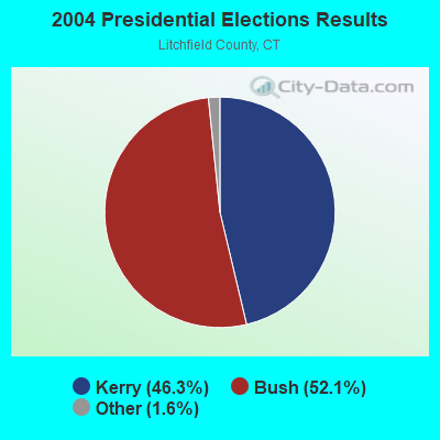
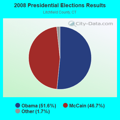
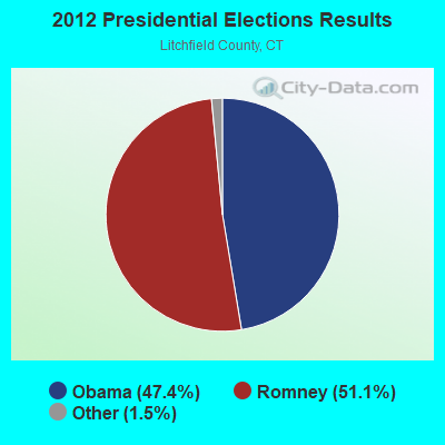
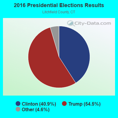
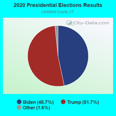
Graphs represent county-level data. Detailed 2008 Election Results
Religion statistics for Salisbury, CT (based on Litchfield County data)
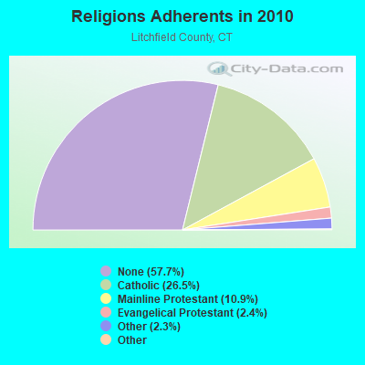
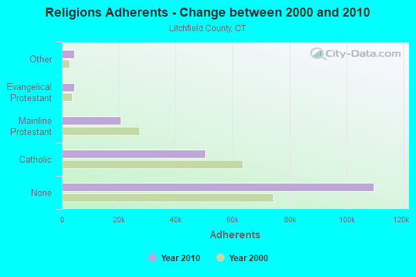
| Religion | Adherents | Congregations |
|---|---|---|
| Catholic | 50,354 | 30 |
| Mainline Protestant | 20,681 | 87 |
| Evangelical Protestant | 4,483 | 39 |
| Other | 4,420 | 16 |
| Orthodox | 175 | 2 |
| Black Protestant | 160 | 2 |
| None | 109,654 | - |
Food Environment Statistics:
| This county: | 2.29 / 10,000 pop. |
| Connecticut: | 2.21 / 10,000 pop. |
| Here: | 0.05 / 10,000 pop. |
| State: | 0.07 / 10,000 pop. |
| Litchfield County: | 0.64 / 10,000 pop. |
| State: | 1.02 / 10,000 pop. |
| Litchfield County: | 2.98 / 10,000 pop. |
| Connecticut: | 2.27 / 10,000 pop. |
| Here: | 11.07 / 10,000 pop. |
| Connecticut: | 9.19 / 10,000 pop. |
| Litchfield County: | 6.9% |
| Connecticut: | 7.3% |
| This county: | 21.1% |
| Connecticut: | 21.5% |
| This county: | 11.8% |
| State: | 15.8% |
Businesses in Salisbury, CT
- MasterBrand Cabinets: 2
Strongest AM radio stations in Salisbury:
- WKZE (1020 AM; daytime; 2 kW; SHARON, CT; Owner: JOHNSON DEVELOPMENT, INC.)
- WNNZ (640 AM; 50 kW; WESTFIELD, MA; Owner: CLEAR CHANNEL BROADCASTING LICENSES, INC.)
- WTIC (1080 AM; 50 kW; HARTFORD, CT; Owner: INFINITY RADIO OPERATIONS INC.)
- WGY (810 AM; 50 kW; SCHENECTADY, NY; Owner: CLEAR CHANNEL BROADCASTING LICENSES, INC.)
- WFAN (660 AM; 50 kW; NEW YORK, NY; Owner: INFINITY BROADCASTING OPERATIONS, INC.)
- WSBS (860 AM; 3 kW; GREAT BARRINGTON, MA; Owner: BERKSHIRE BROADCASTING CO., INC.)
- WPTR (1540 AM; 50 kW; ALBANY, NY; Owner: KIMTRON, INC.)
- WMCA (570 AM; 50 kW; NEW YORK, NY; Owner: SALEM MEDIA OF NEW YORK, LLC)
- WCRN (830 AM; 50 kW; WORCESTER, MA; Owner: CARTER BROADCASTING CORPORATION)
- WABC (770 AM; 50 kW; NEW YORK, NY; Owner: WABC-AM RADIO, INC.)
- WCBS (880 AM; 50 kW; NEW YORK, NY; Owner: INFINITY BROADCASTING OPERATIONS, INC.)
- WOR (710 AM; 50 kW; NEW YORK, NY; Owner: BUCKLEY BROADCASTING CORPORATION)
- WGHQ (920 AM; 5 kW; KINGSTON, NY; Owner: CLEVELAND RADIO LICENSES, LLC)
Strongest FM radio stations in Salisbury:
- WKZE-FM (98.1 FM; SALISBURY, CT; Owner: JOHNSON DEVELOPMENT, INC.)
- WAMQ (105.1 FM; GREAT BARRINGTON, MA; Owner: WAMC)
- WQQQ (103.3 FM; SHARON, CT; Owner: THE RIDGEFIELD BROADCASTING CORPORATION)
- WHVP (91.1 FM; HUDSON, NY; Owner: SOUND OF LIFE, INC.)
- WPDH (101.5 FM; POUGHKEEPSIE, NY; Owner: CUMULUS LICENSING CORP.)
- W206AW (89.1 FM; PAWLING, NY; Owner: SOUND OF LIFE, INC.)
- WAMK (90.9 FM; KINGSTON, NY; Owner: W A M C)
- WFGB (89.7 FM; KINGSTON, NY; Owner: SOUND OF LIFE, INC.)
- W218AV (91.5 FM; WARREN, CT; Owner: MONROE BOARD OF EDUCATION)
- WFNP (88.7 FM; ROSENDALE, NY; Owner: STATE UNIVERSITY OF NEW YORK)
- WRHV (88.7 FM; POUGHKEEPSIE, NY; Owner: WMHT EDUCATIONAL TELECOMMUNICATIONS)
- WRNQ (92.1 FM; POUGHKEEPSIE, NY; Owner: CLEAR CHANNEL BROADCASTING LICENSES, INC.)
- WAMC-FM (90.3 FM; ALBANY, NY; Owner: WAMC)
- WRCH (100.5 FM; NEW BRITAIN, CT; Owner: INFINITY RADIO OPERATIONS INC.)
- WCZX (97.7 FM; HYDE PARK, NY; Owner: CUMULUS LICENSING CORP.)
- WRRB (96.9 FM; ARLINGTON, NY; Owner: CUMULUS LICENSING CORP.)
- WFKP (99.3 FM; ELLENVILLE, NY; Owner: CLEAR CHANNEL BROADCASTING LICENSES, INC.)
- WBWZ (93.3 FM; NEW PALTZ, NY; Owner: CLEVELAND RADIO LICENSES, LLC)
- WRWD-FM (107.3 FM; HIGHLAND, NY; Owner: CLEVELAND RADIO LICENSES, LLC)
- WSPK (104.7 FM; POUGHKEEPSIE, NY; Owner: 6 JOHNSON ROAD LICENSES, INC.)
TV broadcast stations around Salisbury:
- WTIC-TV (Channel 61; HARTFORD, CT; Owner: TRIBUNE TELEVISION COMPANY)
- W11BJ (Channel 11; HARTFORD, CT; Owner: COMMUNICATIONS SITE MANAGEMENT LLC)
- WTXX (Channel 20; WATERBURY, CT; Owner: WTXX INC.)
- WUVN (Channel 18; HARTFORD, CT; Owner: ENTRAVISION HOLDINGS, LLC)
- WVIT (Channel 30; NEW BRITAIN, CT; Owner: OUTLET BROADCASTING, INC)
- WEDH (Channel 24; HARTFORD, CT; Owner: CONNECTICUT PUBLIC BROADCASTING, INC.)
Medal of Honor Recipients
Medal of Honor Recipient born in Salisbury: Elijah A. Briggs.
- National Bridge Inventory (NBI) Statistics
- 10Number of bridges
- 75ft / 22.9mTotal length
- $1,575,000Total costs
- 23,502Total average daily traffic
- 1,311Total average daily truck traffic
- 34,922Total future (year 2029) average daily traffic
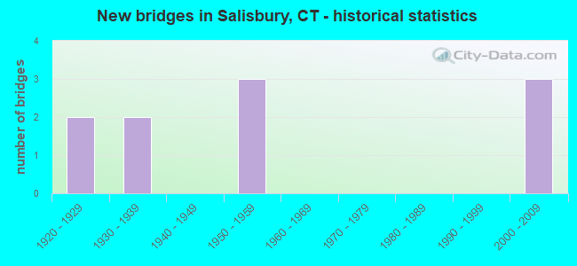
- New bridges - historical statistics
- 21920-1929
- 21930-1939
- 31950-1959
- 32000-2009
FCC Registered Broadcast Land Mobile Towers:
7- South Side Route 44 1/4 Mi W Wildcat Hollow Rd (Lat: 41.998694 Lon: -73.393167), Call Sign: KNBR249,
Assigned Frequencies: 464.450 MHz, 469.450 MHz, Grant Date: 10/04/2001, Expiration Date: 10/21/2011, Cancellation Date: 12/24/2011, Registrant: Three-Way Communications, Inc., East Windsor, CT 06088-1018, Phone: (860) 627-0571, Fax: (860) 627-0572, Email:
- 17 Cobble Road (Lat: 41.989528 Lon: -73.417889), Type: Building, Structure height: 7 m, Overall height: 8 m, Call Sign: WPNT976,
Assigned Frequencies: 462.750 MHz, Grant Date: 06/16/1999, Expiration Date: 06/16/2004, Cancellation Date: 07/20/2004, Certifier: Eileen M Mulligan, Registrant: Visiplex Inc, 1141 Lake Cook Rd Ste G, Deerfield, IL 60015-5235, Fax: (847) 405-0776
- 17 Cobble Rd (Lat: 42.025083 Lon: -73.400944), Type: Bant, Structure height: 7 m, Overall height: 8 m, Call Sign: WQBU420,
Assigned Frequencies: 462.750 MHz, Grant Date: 12/15/2004, Expiration Date: 06/13/2005, Cancellation Date: 08/13/2005, Certifier: Eileen M Mulligan, Registrant: Business Radio Licensing, 26941 Cabot Rd #134, Laguna Hills, CA 92653, Phone: (949) 348-8510
- 1 Fowler Street (Lat: 41.982806 Lon: -73.422472), Type: Bant, Structure height: 10.7 m, Overall height: 14.8 m, Call Sign: WQID974,
Assigned Frequencies: 49.3400 MHz, Grant Date: 01/15/2008, Expiration Date: 01/15/2018, Cancellation Date: 03/17/2018, Certifier: Thomas Sherwood, Registrant: Washington Radio Reports, 1588 Fairfield Road Ste 7, Gettysburg, PA 17325, Phone: (717) 334-0668, Fax: (717) 334-6440, Email:
- Lat: 42.000806 Lon: -73.393667, Call Sign: WQUI587,
Assigned Frequencies: 451.187 MHz, 456.187 MHz, 452.162 MHz, Grant Date: 07/17/2014, Expiration Date: 07/17/2024, Certifier: John Magiera, Registrant: Visiplex, Inc., 1287 North Barclay Boulevard, Buffalo Grove, IL 60089, Phone: (847) 229-0250, Fax: (847) 229-0259, Email:
- 15 Bunker Hill Road (Lat: 41.989944 Lon: -73.430944), Type: Tank, Structure height: 16 m, Overall height: 17 m, Call Sign: WRAR686,
Assigned Frequencies: 219.600 MHz, Grant Date: 02/08/2018, Expiration Date: 02/08/2028, Cancellation Date: 02/08/2018, Certifier: Peter Passeck, Registrant: National License, 12591 Brompton Road, Carmel, IN 46033, Phone: (317) 564-8018, Email:
- 15 Bunker Hill Road (Lat: 41.989944 Lon: -73.430944), Type: Tank, Structure height: 16 m, Overall height: 17 m, Call Sign: WRAR878,
Assigned Frequencies: 219.600 MHz, 218.225 MHz, Grant Date: 02/10/2018, Expiration Date: 02/10/2028, Certifier: Peter Passeck, Registrant: National License, 12591 Brompton Road, Carmel, IN 46033, Phone: (317) 564-8018, Email:
FCC Registered Amateur Radio Licenses:
7- Call Sign: K1LEE, Previous Call Sign: KB1ACN, Licensee ID: L00517332, Grant Date: 08/08/2016, Expiration Date: 11/04/2026, Certifier: K Lee Collins, Registrant: K Lee Collins, 17 Cobble Rd, Salisbury, CT 06068-1501
- Call Sign: KA1RA, Grant Date: 06/29/1995, Expiration Date: 06/29/2005, Cancellation Date: 07/01/2007, Registrant: David A Chard, Salisbury, CT 06068
- Call Sign: KA1SNB, Grant Date: 08/16/1988, Expiration Date: 08/16/1998, Cancellation Date: 08/17/2000, Registrant: James F Fox, Twin Lakes Rd Box 59a, Salisbury, CT 06068
- Call Sign: KC1ABJ, Licensee ID: L01793876, Grant Date: 06/06/2013, Expiration Date: 06/06/2023, Certifier: Charles W Carleton, Registrant: Charles W Carleton, 429 Twin Lakes Rd, Salisbury, CT 06068
- Call Sign: KC1AJX, Licensee ID: L00792167, Grant Date: 08/27/2013, Expiration Date: 08/27/2023, Cancellation Date: 09/15/2018, Certifier: Darrin E Garrison, Registrant: Darrin E Garrison, 179 Under Mountain Rd, Salisbury, CT 06068
- Call Sign: KC1EDP, Licensee ID: L01958591, Grant Date: 07/23/2015, Expiration Date: 07/23/2025, Certifier: Heather E Bartram, Registrant: Heather E Bartram, 120 Under Mt Rd, Salisbury, CT 06068
- Call Sign: KC1GLO, Licensee ID: L02058272, Grant Date: 10/19/2016, Expiration Date: 10/19/2026, Cancellation Date: 02/24/2018, Certifier: Liam Obrien, Registrant: Liam Obrien, 1 Main St, Salisbury, CT 06068
FAA Registered Aircraft:
2- Aircraft: ROBINSON HELICOPTER R44 (Category: Land, Seats: 4, Weight: Up to 12,499 Pounds), Engine: Reciprocating
N-Number: 4055K, N4055K, N-4055K, Serial Number: 2611, Certificate Issue Date: 04/20/2020
Registrant (Individual): William R Jr Harris, 30 Washinee Heights Rd, Salisbury, CT 06068
Deregistered: Cancel Date: 11/27/2006 - Aircraft: RICHMOND JIM R TOP CUB (Category: Amphibian, Seats: 3, Weight: Up to 12,499 Pounds), Engine: LYCOMING O-360-A1A (180 HP) (Reciprocating)
N-Number: 635CC, N635CC, N-635CC, Serial Number: 003, Airworthiness Date: 02/10/2016, Certificate Issue Date: 05/20/2020
Registrant (LLC): Aeroplane Services LLC, Po Box 15, Salisbury, CT 06068
Deregistered: Cancel Date: 09/06/2019
2002 - 2018 National Fire Incident Reporting System (NFIRS) incidents
- Fire incident types reported to NFIRS in Salisbury, CT
- 12873.6%Structure Fires
- 2614.9%Outside Fires
- 169.2%Mobile Property/Vehicle Fires
- 42.3%Other
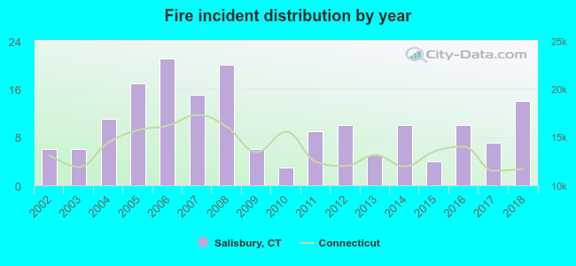 Based on the data from the years 2002 - 2018 the average number of fires per year is 10. The highest number of fire incidents - 21 took place in 2006, and the least - 3 in 2010. The data has a rising trend.
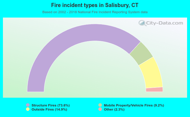 When looking into fire subcategories, the most incidents belonged to: Structure Fires (73.6%), and Outside Fires (14.9%).
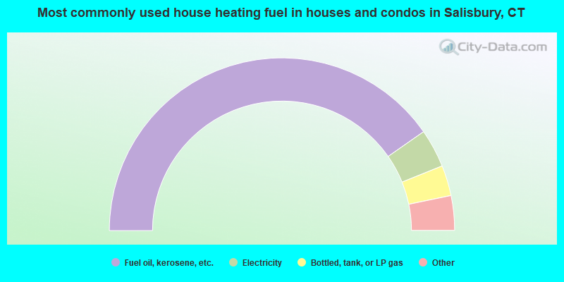
- 80.6%Fuel oil, kerosene, etc.
- 7.2%Electricity
- 5.7%Bottled, tank, or LP gas
- 3.7%Wood
- 1.9%Utility gas
- 0.8%Other fuel
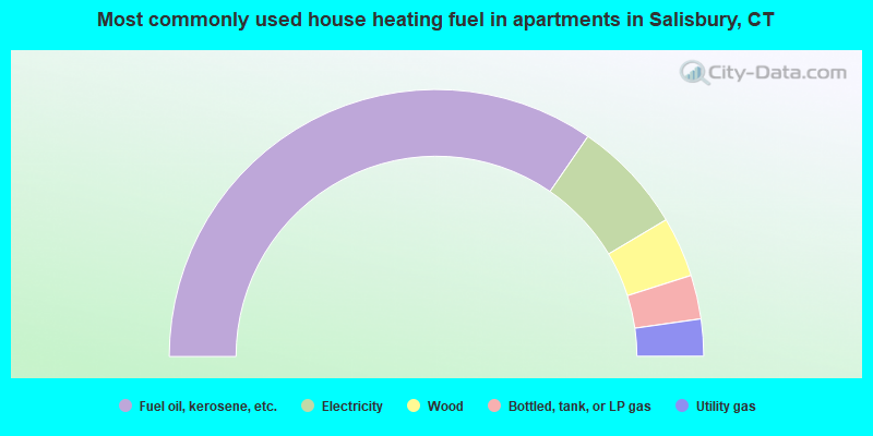
- 69.2%Fuel oil, kerosene, etc.
- 13.7%Electricity
- 7.3%Wood
- 5.3%Bottled, tank, or LP gas
- 4.5%Utility gas
Salisbury compared to Connecticut state average:
- Median house value above state average.
- Unemployed percentage significantly below state average.
- Black race population percentage significantly below state average.
- Hispanic race population percentage significantly below state average.
- Median age significantly above state average.
- Foreign-born population percentage significantly below state average.
- Length of stay since moving in significantly above state average.
- Number of rooms per house significantly below state average.
- House age significantly below state average.
- Institutionalized population percentage above state average.
- Number of college students below state average.
- Percentage of population with a bachelor's degree or higher above state average.
Salisbury on our top lists:
- #60 on the list of "Top 101 cities with the largest percentage of people in other nonhousehold living situations (population 1,000+)"
- #7 on the list of "Top 101 counties with the lowest Particulate Matter (PM10) Annual air pollution readings in 2012 (µg/m3)"
- #10 on the list of "Top 101 counties with the lowest number of births per 1000 residents 2007-2013"
- #21 on the list of "Top 101 counties with the largest decrease in the number of births per 1000 residents 2000-2006 to 2007-2013 (pop 50,000+)"
- #38 on the list of "Top 101 counties with the lowest Particulate Matter (PM2.5) Annual air pollution readings in 2012 (µg/m3)"
- #39 on the list of "Top 101 counties with the highest carbon monoxide air pollution readings in 2012 (ppm)"

|
Total of 5 patent applications in 2008-2024.