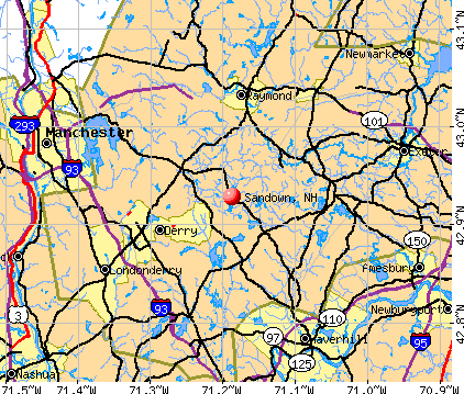
Sandown, New Hampshire
Submit your own pictures of this town and show them to the world
- OSM Map
- General Map
- Google Map
- MSN Map
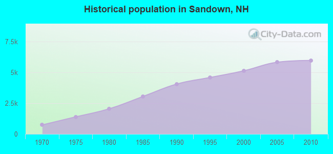
Population change since 2000: +16.4%
 |
| Males: 3,024 | |
| Females: 2,962 |
| Median resident age: | 40.4 years |
| New Hampshire median age: | 43.9 years |
Zip codes: 03873.
| Sandown: | $124,867 |
| NH: | $89,992 |
Estimated per capita income in 2022: $57,025 (it was $25,978 in 2000)
Sandown town income, earnings, and wages data
Estimated median house or condo value in 2022: $439,088 (it was $143,700 in 2000)
| Sandown: | $439,088 |
| NH: | $384,700 |
Mean prices in 2022: all housing units: $614,227; detached houses: $665,470; townhouses or other attached units: $408,866; in 2-unit structures: $730,084; in 3-to-4-unit structures: over $1,000,000; in 5-or-more-unit structures: $329,099; mobile homes: $126,160
Detailed information about poverty and poor residents in Sandown, NH
Compare current foreclosures near Sandown, NH:
| Photo | Address | Area | Beds / Baths | Price | Details |
|---|---|---|---|---|---|

|
#1
Hemlock Cir
Sandown, NH 03873
|
1,912 sq. feet
|
2 baths 4 beds |
show details | |

|
#2
Brentwood Rd
Exeter, NH 03833
|
2,756 sq. feet
|
2 baths 3 beds |
$419,900
|
show details |

|
#3
Cedar St # A
Haverhill, MA 01830
|
1,134 sq. feet
|
2 baths 2 beds |
$209,300
|
show details |

|
#4
Shore Dr
Hampstead, NH 03841
|
787 sq. feet
|
1 baths 2 beds |
$529,900
|
show details |

|
#5
Wells Village Rd
Sandown, NH 03873
|
- sq. feet
|
- baths - beds |
show details | |

|
#6
Phillipswood Rd
Sandown, NH 03873
|
- sq. feet
|
- baths - beds |
show details | |

|
#7
Reed Rd
Sandown, NH 03873
|
- sq. feet
|
- baths - beds |
show details | |

|
#8
Hale True Rd
Sandown, NH 03873
|
- sq. feet
|
- baths - beds |
show details | |

|
#9
Page St
Manchester, NH 03104
|
4,105 sq. feet
|
3 baths 5 beds |
show details | |

|
#10
Cheney Dr
Hudson, NH 03051
|
1,685 sq. feet
|
2 baths 3 beds |
show details |
| Photo | Address | Area | Beds / Baths | Price | Details |
|---|---|---|---|---|---|

|
#11
Williamine Dr
Newton, NH 03858
|
2,295 sq. feet
|
1 baths 3 beds |
show details | |

|
#12
Byron St
Haverhill, MA 01835
|
2,446 sq. feet
|
2 baths 4 beds |
show details | |

|
#13
Lincoln Ave
Newmarket, NH 03857
|
1,568 sq. feet
|
3 baths 3 beds |
show details | |

|
#14
S Mammoth Rd
Manchester, NH 03109
|
1,555 sq. feet
|
2 baths 4 beds |
show details | |

|
#15
Pine Ridge Rd
Windham, NH 03087
|
1,746 sq. feet
|
2 baths 4 beds |
show details | |

|
#16
Smoke St
Nottingham, NH 03290
|
2,681 sq. feet
|
2 baths 3 beds |
show details | |

|
#17
S Broadway
Lawrence, MA 01843
|
5,706 sq. feet
|
2 baths 6 beds |
show details | |

|
#18
Blucher St
Manchester, NH 03102
|
2,448 sq. feet
|
2 baths 3 beds |
show details | |

|
#19
Frances Street Aka 57 Francis Street
Haverhill, MA 01830
|
1,280 sq. feet
|
2 baths 3 beds |
show details | |

|
#20
High St
Derry, NH 03038
|
2,149 sq. feet
|
3 baths 4 beds |
show details |
| Photo | Address | Area | Beds / Baths | Price | Details |
|---|---|---|---|---|---|

|
#21
Oak Ridge Rd
Plaistow, NH 03865
|
3,089 sq. feet
|
3 baths 5 beds |
show details | |

|
#22
Beede Hill Rd
Fremont, NH 03044
|
1,135 sq. feet
|
1 baths 3 beds |
show details | |

|
#23
Thornton St
Lawrence, MA 01841
|
912 sq. feet
|
1 baths 2 beds |
show details | |

|
#24
Granite St
Manchester, NH 03102
|
1,905 sq. feet
|
2 baths 4 beds |
show details | |

|
#25
Brook St
Derry, NH 03038
|
1,476 sq. feet
|
2 baths 4 beds |
show details | |

|
#26
Windbrook Dr
Epping, NH 03042
|
1,680 sq. feet
|
1 baths 3 beds |
show details | |

|
#27
Glen Forest Ln
Methuen, MA 01844
|
1,904 sq. feet
|
2 baths 3 beds |
show details | |

|
#28
Tokanel Rd
Windham, NH 03087
|
- sq. feet
|
1 baths 3 beds |
show details | |

|
#29
Hobson St
Methuen, MA 01844
|
1,776 sq. feet
|
1 baths 3 beds |
show details | |

|
#30
Hobson St
Methuen, MA 01844
|
1,776 sq. feet
|
1 baths 3 beds |
show details |
| Photo | Address | Area | Beds / Baths | Price | Details |
|---|---|---|---|---|---|

|
#31
Westwood Dr
Manchester, NH 03103
|
2,086 sq. feet
|
1 baths 3 beds |
show details | |

|
#32
Gauthier Way
Pelham, NH 03076
|
2,752 sq. feet
|
2 baths 3 beds |
show details | |

|
#33
Anderson Dr
Methuen, MA 01844
|
2,592 sq. feet
|
2 baths 4 beds |
show details | |

|
#34
Christopher Dr Apt 114
Methuen, MA 01844
|
1,040 sq. feet
|
2 baths 2 beds |
show details | |

|
#35
Hallenan Ave
Lawrence, MA 01841
|
1,564 sq. feet
|
1 baths 3 beds |
show details | |

|
#36
Pimlico Ct # 91
Bedford, NH 03110
|
1,836 sq. feet
|
1 baths 2 beds |
show details | |

|
#37
Whittier Meadows Dr
Amesbury, MA 01913
|
1,344 sq. feet
|
2 baths 2 beds |
show details | |

|
#38
Lucille St
Manchester, NH 03103
|
1,425 sq. feet
|
2 baths 4 beds |
show details | |

|
#39
Kingsbury Ave
Haverhill, MA 01835
|
1,118 sq. feet
|
2 baths 3 beds |
show details | |

|
#40
Pimlico Ct
Bedford, NH 03110
|
1,836 sq. feet
|
1 baths 2 beds |
show details |
| Photo | Address | Area | Beds / Baths | Price | Details |
|---|---|---|---|---|---|

|
#41
Revere Ave
Manchester, NH 03109
|
3,240 sq. feet
|
2 baths 2 beds |
show details | |

|
#42
Marshall St
Methuen, MA 01844
|
840 sq. feet
|
1 baths 2 beds |
show details | |

|
#43
Putnam St
Manchester, NH 03102
|
1,530 sq. feet
|
1 baths 2 beds |
show details | |

|
#44
S Elm St
Haverhill, MA 01835
|
1,122 sq. feet
|
1 baths 4 beds |
show details | |

|
#45
Cluff Crossing Rd
Salem, NH 03079
|
1,120 sq. feet
|
2 baths 2 beds |
show details | |

|
#46
Whitehall Rd
Hooksett, NH 03106
|
2,740 sq. feet
|
2 baths 5 beds |
show details | |

|
#47
Washington St
Haverhill, MA 01832
|
3,162 sq. feet
|
5 baths 5 beds |
show details | |

|
#48
Harvard St
Exeter, NH 03833
|
1,509 sq. feet
|
1 baths 3 beds |
show details | |

|
#49
Baldwin St
Haverhill, MA 01832
|
2,504 sq. feet
|
2 baths 6 beds |
show details | |

|
Check over 1 million property listings on Foreclosure.com!
|
browse all offers | |||

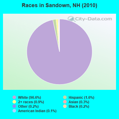
- 5,78596.6%White alone
- 941.6%Hispanic
- 560.9%Two or more races
- 170.3%Asian alone
- 120.2%Black alone
- 140.2%Other race alone
- 70.1%American Indian alone
- 10.02%Native Hawaiian and Other
Pacific Islander alone
Races in Sandown detailed stats: ancestries, foreign born residents, place of birth
According to our research of New Hampshire and other state lists, there were 3 registered sex offenders living in Sandown, New Hampshire as of April 26, 2024.
The ratio of all residents to sex offenders in Sandown is 1,995 to 1.
The ratio of registered sex offenders to all residents in this city is much lower than the state average.
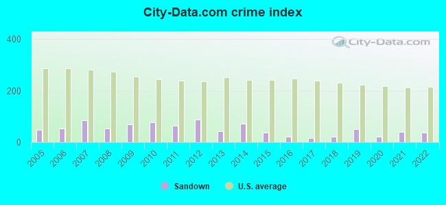
Type |
2009 |
2010 |
2011 |
2012 |
2013 |
2014 |
2015 |
2016 |
2017 |
2018 |
2019 |
2020 |
2021 |
2022 |
|---|---|---|---|---|---|---|---|---|---|---|---|---|---|---|
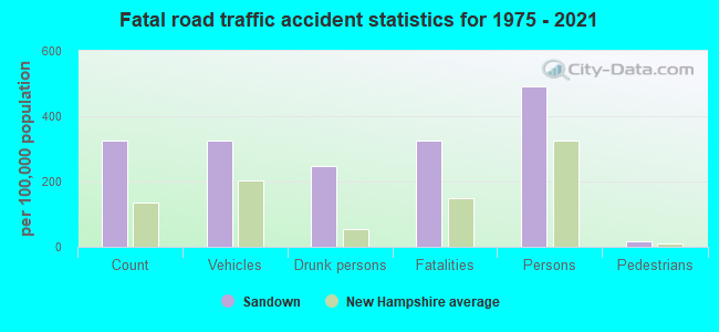
| Murders (per 100,000) | 0 (0.0) | 0 (0.0) | 0 (0.0) | 1 (16.6) | 0 (0.0) | 0 (0.0) | 0 (0.0) | 0 (0.0) | 0 (0.0) | 0 (0.0) | 1 (15.4) | 0 (0.0) | 0 (0.0) | 0 (0.0) |
| Rapes (per 100,000) | 0 (0.0) | 2 (33.4) | 1 (16.7) | 0 (0.0) | 1 (16.2) | 3 (48.1) | 0 (0.0) | 0 (0.0) | 0 (0.0) | 0 (0.0) | 0 (0.0) | 1 (15.1) | 2 (29.9) | 2 (30.4) |
| Robberies (per 100,000) | 0 (0.0) | 0 (0.0) | 0 (0.0) | 0 (0.0) | 0 (0.0) | 0 (0.0) | 0 (0.0) | 0 (0.0) | 0 (0.0) | 0 (0.0) | 0 (0.0) | 0 (0.0) | 0 (0.0) | 0 (0.0) |
| Assaults (per 100,000) | 4 (67.2) | 1 (16.7) | 1 (16.7) | 4 (66.5) | 0 (0.0) | 0 (0.0) | 4 (63.4) | 1 (15.8) | 1 (15.7) | 2 (30.8) | 1 (15.4) | 0 (0.0) | 1 (14.9) | 0 (0.0) |
| Burglaries (per 100,000) | 20 (336.2) | 18 (300.7) | 18 (300.3) | 15 (249.2) | 11 (177.9) | 6 (96.2) | 7 (110.9) | 8 (126.0) | 5 (78.5) | 1 (15.4) | 7 (107.7) | 1 (15.1) | 1 (14.9) | 2 (30.4) |
| Thefts (per 100,000) | 41 (689.3) | 32 (534.6) | 35 (583.9) | 33 (548.3) | 17 (274.9) | 30 (480.8) | 19 (301.1) | 15 (236.3) | 11 (172.7) | 18 (276.9) | 11 (169.2) | 12 (181.3) | 16 (239.1) | 17 (258.6) |
| Auto thefts (per 100,000) | 3 (50.4) | 3 (50.1) | 2 (33.4) | 2 (33.2) | 4 (64.7) | 5 (80.1) | 4 (63.4) | 0 (0.0) | 1 (15.7) | 2 (30.8) | 2 (30.8) | 1 (15.1) | 2 (29.9) | 1 (15.2) |
| Arson (per 100,000) | 1 (16.8) | 0 (0.0) | 0 (0.0) | 0 (0.0) | 2 (32.3) | 0 (0.0) | 0 (0.0) | 0 (0.0) | 0 (0.0) | 0 (0.0) | 0 (0.0) | 0 (0.0) | 0 (0.0) | 0 (0.0) |
| City-Data.com crime index | 68.6 | 76.5 | 63.7 | 88.6 | 41.6 | 70.8 | 37.6 | 21.4 | 16.8 | 20.8 | 50.6 | 21.6 | 39.9 | 38.0 |
The City-Data.com crime index weighs serious crimes and violent crimes more heavily. Higher means more crime, U.S. average is 246.1. It adjusts for the number of visitors and daily workers commuting into cities.
Crime rate in Sandown detailed stats: murders, rapes, robberies, assaults, burglaries, thefts, arson
Full-time law enforcement employees in 2021, including police officers: 9 (8 officers - 6 male; 2 female).
| Officers per 1,000 residents here: | 1.20 |
| New Hampshire average: | 2.14 |
 Recent articles from our blog. Our writers, many of them Ph.D. graduates or candidates, create easy-to-read articles on a wide variety of topics.

 | Thoughts on the Free State Project (82 replies) |
| Life in Sandown nh (4 replies) |
| Where to find period, old homes for sale? (20 replies) |
| Sandown? (3 replies) |
| Middleton N.H tax rate? (17 replies) |
| Relocation to new hampshire (28 replies) |
Latest news from Sandown, NH collected exclusively by city-data.com from local newspapers, TV, and radio stations
Ancestries: Irish (24.5%), English (18.2%), French (15.4%), Italian (14.6%), French Canadian (11.8%), German (7.0%).
Current Local Time: EST time zone
Incorporated in 1756
Elevation: 232 feet
Land area: 13.9 square miles.
Population density: 430 people per square mile (low).
161 residents are foreign born (1.8% North America, 1.0% Europe).
| This town: | 3.1% |
| New Hampshire: | 4.4% |
| Sandown town: | 2.5% ($3,572) |
| New Hampshire: | 2.3% ($2,946) |
Nearest city with pop. 50,000+: Haverhill, MA  (11.6 miles , pop. 58,969).
Nearest city with pop. 200,000+: Boston, MA (42.3 miles , pop. 589,141).
Nearest city with pop. 1,000,000+: Bronx, NY (199.8 miles , pop. 1,332,650).
Nearest cities:
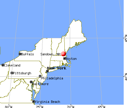
), ), ), ), )Latitude: 42.93 N, Longitude: 71.18 W
Area code commonly used in this area: 603

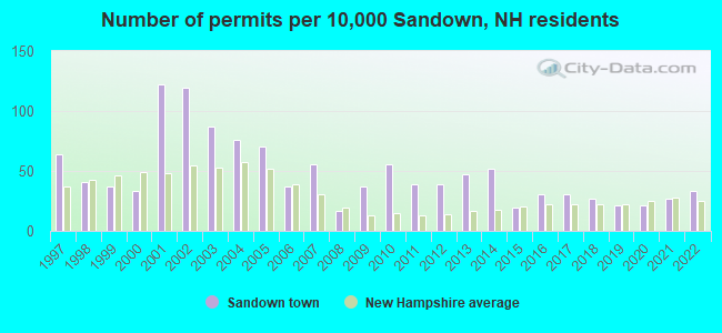
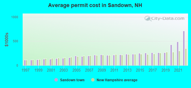
Single-family new house construction building permits:
- 2022: 17 buildings, average cost: $714,700
- 2021: 14 buildings, average cost: $492,900
- 2020: 11 buildings, average cost: $426,600
- 2019: 11 buildings, average cost: $264,100
- 2018: 14 buildings, average cost: $266,000
- 2017: 16 buildings, average cost: $266,700
- 2016: 16 buildings, average cost: $260,300
- 2015: 10 buildings, average cost: $257,200
- 2014: 27 buildings, average cost: $239,200
- 2013: 24 buildings, average cost: $233,900
- 2012: 20 buildings, average cost: $226,100
- 2011: 20 buildings, average cost: $220,300
- 2010: 29 buildings, average cost: $213,300
- 2009: 19 buildings, average cost: $225,300
- 2008: 9 buildings, average cost: $218,400
- 2007: 29 buildings, average cost: $201,700
- 2006: 19 buildings, average cost: $189,400
- 2005: 36 buildings, average cost: $201,400
- 2004: 39 buildings, average cost: $163,600
- 2003: 45 buildings, average cost: $153,100
- 2002: 61 buildings, average cost: $145,800
- 2001: 63 buildings, average cost: $136,100
- 2000: 17 buildings, average cost: $131,500
- 1999: 19 buildings, average cost: $122,600
- 1998: 21 buildings, average cost: $116,000
- 1997: 33 buildings, average cost: $112,200
| Here: | 2.6% |
| New Hampshire: | 2.5% |
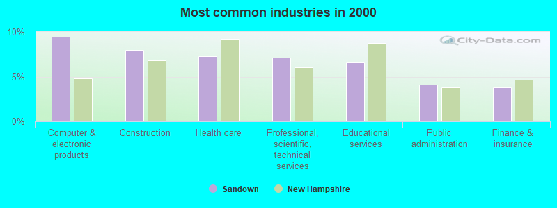
- Computer & electronic products (9.4%)
- Construction (8.0%)
- Health care (7.3%)
- Professional, scientific, technical services (7.1%)
- Educational services (6.6%)
- Public administration (4.1%)
- Finance & insurance (3.8%)
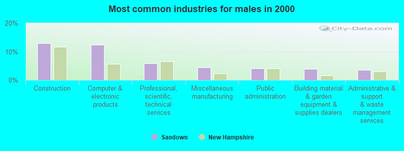
- Construction (12.9%)
- Computer & electronic products (12.4%)
- Professional, scientific, technical services (5.8%)
- Miscellaneous manufacturing (4.3%)
- Public administration (4.0%)
- Building material & garden equipment & supplies dealers (3.8%)
- Administrative & support & waste management services (3.5%)
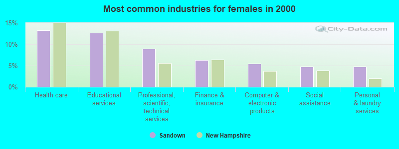
- Health care (13.2%)
- Educational services (12.7%)
- Professional, scientific, technical services (8.9%)
- Finance & insurance (6.2%)
- Computer & electronic products (5.5%)
- Social assistance (4.8%)
- Personal & laundry services (4.7%)
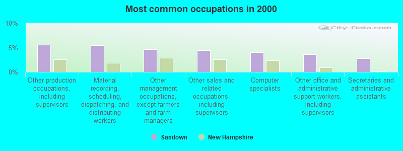
- Other production occupations, including supervisors (5.6%)
- Material recording, scheduling, dispatching, and distributing workers (5.4%)
- Other management occupations, except farmers and farm managers (4.6%)
- Other sales and related occupations, including supervisors (4.4%)
- Computer specialists (4.0%)
- Other office and administrative support workers, including supervisors (3.6%)
- Secretaries and administrative assistants (2.7%)
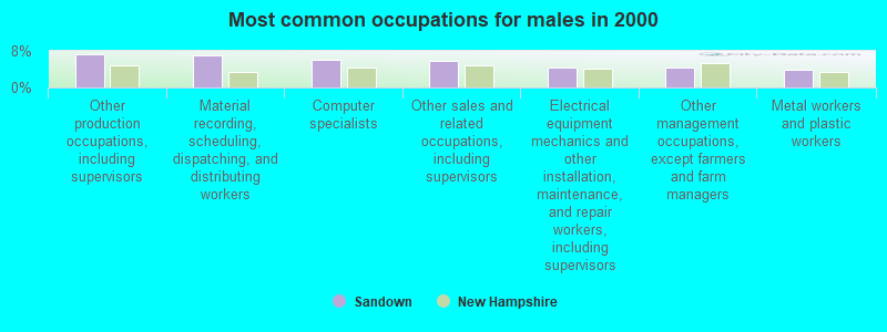
- Other production occupations, including supervisors (7.4%)
- Material recording, scheduling, dispatching, and distributing workers (7.0%)
- Computer specialists (6.2%)
- Other sales and related occupations, including supervisors (5.7%)
- Electrical equipment mechanics and other installation, maintenance, and repair workers, including supervisors (4.4%)
- Other management occupations, except farmers and farm managers (4.3%)
- Metal workers and plastic workers (3.9%)
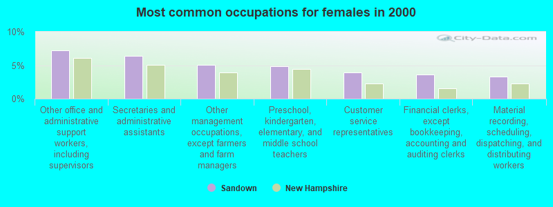
- Other office and administrative support workers, including supervisors (7.3%)
- Secretaries and administrative assistants (6.4%)
- Other management occupations, except farmers and farm managers (5.1%)
- Preschool, kindergarten, elementary, and middle school teachers (4.9%)
- Customer service representatives (3.9%)
- Financial clerks, except bookkeeping, accounting and auditing clerks (3.6%)
- Material recording, scheduling, dispatching, and distributing workers (3.3%)
Average climate in Sandown, New Hampshire
Based on data reported by over 4,000 weather stations


(lower is better)
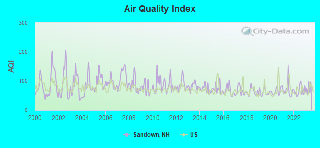
Air Quality Index (AQI) level in 2022 was 66.4. This is about average.
| City: | 66.4 |
| U.S.: | 72.6 |
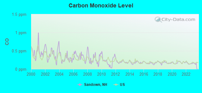
Carbon Monoxide (CO) [ppm] level in 2022 was 0.157. This is significantly better than average. Closest monitor was 10.9 miles away from the city center.
| City: | 0.157 |
| U.S.: | 0.251 |
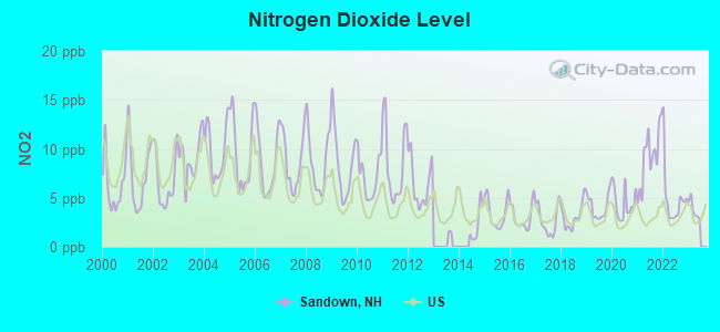
Nitrogen Dioxide (NO2) [ppb] level in 2022 was 4.90. This is about average. Closest monitor was 4.9 miles away from the city center.
| City: | 4.90 |
| U.S.: | 5.11 |
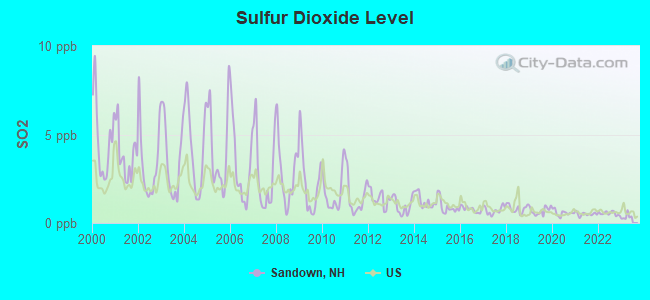
Sulfur Dioxide (SO2) [ppb] level in 2022 was 0.541. This is significantly better than average. Closest monitor was 10.9 miles away from the city center.
| City: | 0.541 |
| U.S.: | 1.515 |
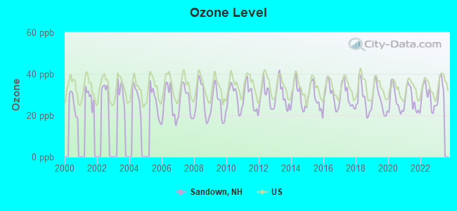
Ozone [ppb] level in 2022 was 28.8. This is about average. Closest monitor was 10.9 miles away from the city center.
| City: | 28.8 |
| U.S.: | 33.3 |
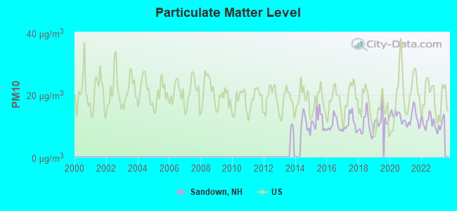
Particulate Matter (PM10) [µg/m3] level in 2022 was 11.2. This is significantly better than average. Closest monitor was 10.9 miles away from the city center.
| City: | 11.2 |
| U.S.: | 19.2 |
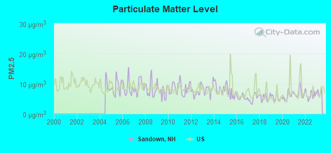
Particulate Matter (PM2.5) [µg/m3] level in 2022 was 6.26. This is better than average. Closest monitor was 10.9 miles away from the city center.
| City: | 6.26 |
| U.S.: | 8.11 |
Tornado activity:
Sandown-area historical tornado activity is slightly above New Hampshire state average. It is 43% smaller than the overall U.S. average.
On 6/9/1953, a category F3 (max. wind speeds 158-206 mph) tornado 11.2 miles away from the Sandown town center injured 5 people and caused between $5000 and $50,000 in damages.
On 9/29/1974, a category F3 tornado 21.4 miles away from the town center injured one person and caused between $50,000 and $500,000 in damages.
Earthquake activity:
Sandown-area historical earthquake activity is significantly above New Hampshire state average. It is 72% smaller than the overall U.S. average.On 4/20/2002 at 10:50:47, a magnitude 5.3 (5.3 ML, Depth: 3.0 mi, Class: Moderate, Intensity: VI - VII) earthquake occurred 166.6 miles away from the city center
On 1/19/1982 at 00:14:42, a magnitude 4.7 (4.5 MB, 4.7 MD, 4.5 LG, Class: Light, Intensity: IV - V) earthquake occurred 44.7 miles away from Sandown center
On 10/7/1983 at 10:18:46, a magnitude 5.3 (5.1 MB, 5.3 LG, 5.1 ML) earthquake occurred 173.6 miles away from Sandown center
On 10/16/2012 at 23:12:25, a magnitude 4.7 (4.7 ML, Depth: 10.0 mi) earthquake occurred 53.3 miles away from the city center
On 4/20/2002 at 10:50:47, a magnitude 5.2 (5.2 MB, 4.2 MS, 5.2 MW, 5.0 MW) earthquake occurred 166.3 miles away from Sandown center
On 8/22/1992 at 12:20:32, a magnitude 4.8 (4.8 MB, 3.8 MS, 4.7 LG, Depth: 6.2 mi) earthquake occurred 268.3 miles away from Sandown center
Magnitude types: regional Lg-wave magnitude (LG), body-wave magnitude (MB), duration magnitude (MD), local magnitude (ML), surface-wave magnitude (MS), moment magnitude (MW)
Natural disasters:
The number of natural disasters in Rockingham County (26) is a lot greater than the US average (15).Major Disasters (Presidential) Declared: 17
Emergencies Declared: 9
Causes of natural disasters: Storms: 12, Floods: 9, Winter Storms: 5, Hurricanes: 4, Snowstorms: 4, Snows: 2, Winds: 2, Blizzard: 1, Snowfall: 1, Tornado: 1 (Note: some incidents may be assigned to more than one category).
Hospitals and medical centers near Sandown:
- HAMPSTEAD HOSP (Hospital, about 5 miles away; HAMPSTEAD, NH)
- COLONIAL POPLIN NURSING HOME (Nursing Home, about 5 miles away; FREMONT, NH)
- AURORA SENIOR LIVING OF DERRY, LLC (Nursing Home, about 7 miles away; DERRY, NH)
- PLEASANT VALLEY NURSING CENTER (Nursing Home, about 8 miles away; DERRY, NH)
- PARKLAND MEDICAL CENTER Acute Care Hospitals (about 8 miles away; DERRY, NH)
- COLUMBIA HOMECARE PARKLAND MEDICAL CTR (Home Health Center, about 8 miles away; DERRY, NH)
- NUTFIELD SURGICENTER (Hospital, about 8 miles away; DERRY, NH)
Operable nuclear power plant near Sandown:
- 17 miles: Seabrook in Seabrook, NH.
Colleges/universities with over 2000 students nearest to Sandown:
- Northern Essex Community College (about 12 miles; Haverhill, MA; Full-time enrollment: 4,737)
- Mount Washington College (about 15 miles; Manchester, NH; FT enrollment: 2,187)
- Southern New Hampshire University (about 16 miles; Manchester, NH; FT enrollment: 16,552)
- Saint Anselm College (about 17 miles; Manchester, NH; FT enrollment: 2,059)
- Merrimack College (about 19 miles; North Andover, MA; FT enrollment: 2,734)
- University of New Hampshire-Main Campus (about 19 miles; Durham, NH; FT enrollment: 15,243)
- University of Massachusetts-Lowell (about 21 miles; Lowell, MA; FT enrollment: 12,341)
Public elementary/middle schools in Sandown:
- SANDOWN NORTH ELEMENTARY SCHOOL (Students: 236, Location: 23 STAGECOACH RD., Grades: PK-3)
- SANDOWN CENTRAL SCHOOL (Students: 172, Location: 295 MAIN ST., Grades: 4-5)
Private elementary/middle school in Sandown:
Points of interest:
Notable locations in Sandown: Angle Pond Campground (A), Sandown Fire and Rescue Substation (B), Sandown Fire and Rescue (C), Sandown Town Hall (D). Display/hide their locations on the map
Churches in Sandown include: Fellowship In His Love Church (A), Saint Matthews United Methodist Church (B). Display/hide their locations on the map
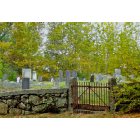
Cemeteries: North Cemetery (1), Center Cemetery (2), Wells Cemetery (3), Pine Grove Cemetery (4). Display/hide their locations on the map
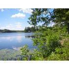
Lakes and reservoirs: Cub Pond (A), Hunt Pond (B), Lily Pond (C), Phillips Pond (D), Punch Pond (E), Showell Pond (F), Angle Pond (G). Display/hide their locations on the map
Drinking water stations with addresses in Sandown and their reported violations in the past:
ZORVINO VINEYARDS (Population served: 120, Groundwater):Past monitoring violations:MILL PINE VILLAGE (Population served: 98, Groundwater):
- 2 routine major monitoring violations
Past monitoring violations:SANDOWN TOWN HALL FIRE STATION (Population served: 30, Groundwater):
- Monitoring and Reporting (DBP) - Between JUL-01-2010 and OCT-01-2010, Contaminant: Chlorine. Follow-up actions: St Violation/Reminder Notice (OCT-29-2010), St Compliance achieved (MAR-16-2011)
Past health violations:Past monitoring violations:
- MCL, Monthly (TCR) - Between OCT-2007 and DEC-2007, Contaminant: Coliform. Follow-up actions: St Public Notif requested (JAN-02-2008), St Violation/Reminder Notice (JAN-02-2008), St Public Notif received (JAN-14-2008), St Compliance achieved (NOV-26-2008)
- MCL, Monthly (TCR) - Between JUL-2007 and SEP-2007, Contaminant: Coliform. Follow-up actions: St Public Notif requested (JUL-17-2007), St Violation/Reminder Notice (JUL-17-2007), St Formal NOV issued (JUL-20-2007), St Public Notif received (AUG-31-2007), St Compliance achieved (NOV-26-2008)
- MCL, Monthly (TCR) - Between APR-2007 and JUN-2007, Contaminant: Coliform. Follow-up actions: St Public Notif requested (JUL-02-2007), St Violation/Reminder Notice (JUL-02-2007), St Formal NOV issued (JUL-20-2007), St Public Notif received (AUG-31-2007), St Compliance achieved (NOV-26-2008)
- One routine major monitoring violation
| This town: | 2.9 people |
| New Hampshire: | 2.5 people |
| This town: | 80.9% |
| Whole state: | 66.3% |
| This town: | 8.4% |
| Whole state: | 8.3% |
Likely homosexual households (counted as self-reported same-sex unmarried-partner households)
- Lesbian couples: 0.6% of all households
- Gay men: 0.4% of all households
| This town: | 4.1% |
| Whole state: | 6.5% |
| This town: | 1.9% |
| Whole state: | 2.8% |
30 people in other noninstitutional group quarters in 2000
2 people in other group homes in 2000
For population 15 years and over in Sandown:
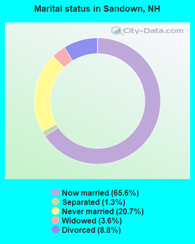
- Never married: 20.7%
- Now married: 65.6%
- Separated: 1.3%
- Widowed: 3.6%
- Divorced: 8.8%
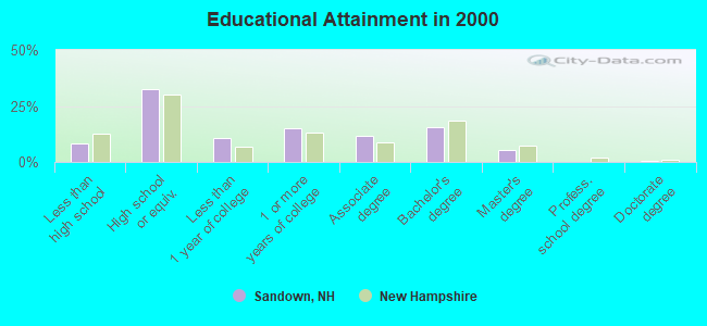
For population 25 years and over in Sandown:
- High school or higher: 91.7%
- Bachelor's degree or higher: 21.6%
- Graduate or professional degree: 6.1%
- Unemployed: 3.0%
- Mean travel time to work (commute): 34.4 minutes
| Here: | 8.7 |
| New Hampshire average: | 10.9 |


Graphs represent county-level data. Detailed 2008 Election Results
Religion statistics for Sandown, NH (based on Rockingham County data)


| Religion | Adherents | Congregations |
|---|---|---|
| Catholic | 84,697 | 24 |
| Mainline Protestant | 19,072 | 78 |
| Evangelical Protestant | 7,456 | 61 |
| Other | 3,490 | 20 |
| Orthodox | 200 | 1 |
| None | 180,308 | - |
Food Environment Statistics:
| Rockingham County: | 1.59 / 10,000 pop. |
| New Hampshire: | 2.14 / 10,000 pop. |
| Here: | 0.17 / 10,000 pop. |
| New Hampshire: | 0.15 / 10,000 pop. |
| This county: | 1.86 / 10,000 pop. |
| New Hampshire: | 1.78 / 10,000 pop. |
| Rockingham County: | 3.31 / 10,000 pop. |
| State: | 4.02 / 10,000 pop. |
| Here: | 9.56 / 10,000 pop. |
| State: | 9.70 / 10,000 pop. |
| Rockingham County: | 7.6% |
| New Hampshire: | 7.6% |
| Here: | 23.3% |
| State: | 24.4% |
| This county: | 16.8% |
| New Hampshire: | 15.9% |
7.69% of this county's 2021 resident taxpayers lived in other counties in 2020 ($114,534 average adjusted gross income)
| Here: | 7.69% |
| New Hampshire average: | 7.66% |
0.01% of residents moved from foreign countries ($203 average AGI)
Rockingham County: 0.01% New Hampshire average: 0.01%
Top counties from which taxpayers relocated into this county between 2020 and 2021:
| from Essex County, MA | |
| from Hillsborough County, NH | |
| from Middlesex County, MA |
6.82% of this county's 2020 resident taxpayers moved to other counties in 2021 ($88,778 average adjusted gross income)
| Here: | 6.82% |
| New Hampshire average: | 6.80% |
0.01% of residents moved to foreign countries ($126 average AGI)
Rockingham County: 0.01% New Hampshire average: 0.01%
Top counties to which taxpayers relocated from this county between 2020 and 2021:
| to Hillsborough County, NH | |
| to Strafford County, NH | |
| to Essex County, MA |
Strongest AM radio stations in Sandown:
- WDER (1320 AM; 10 kW; DERRY, NH; Owner: BLOUNT COMMUNICATIONS, INC. OF NH)
- WRKO (680 AM; 50 kW; BOSTON, MA; Owner: ENTERCOM BOSTON LICENSE, LLC)
- WGIR (610 AM; 5 kW; MANCHESTER, NH; Owner: CAPSTAR TX LIMITED PARTNERSHIP)
- WCEC (1110 AM; daytime; 5 kW; SALEM, NH; Owner: COSTA-EAGLE RADIO VENTURES LTD PARTNERSHIP)
- WEEI (850 AM; 50 kW; BOSTON, MA; Owner: ENTERCOM BOSTON LICENSE, LLC)
- WWZN (1510 AM; 50 kW; BOSTON, MA; Owner: ROSE CITY RADIO CORPORATION)
- WBZ (1030 AM; 50 kW; BOSTON, MA; Owner: INFINITY BROADCASTING OPERATIONS, INC.)
- WKOX (1200 AM; 50 kW; FRAMINGHAM, MA; Owner: CAPSTAR TX LIMITED PARTNERSHIP)
- WGIP (1540 AM; 5 kW; EXETER, NH; Owner: CAPSTAR TX LIMITED PARTNERSHIP)
- WFEA (1370 AM; 5 kW; MANCHESTER, NH; Owner: SAGA COMMUNICATIONS OF NEW ENGLAND, LLC)
- WBIX (1060 AM; 40 kW; NATICK, MA; Owner: LANGER BROADCASTING CORPORATION)
- WCRN (830 AM; 50 kW; WORCESTER, MA; Owner: CARTER BROADCASTING CORPORATION)
- WGIN (930 AM; 10 kW; ROCHESTER, NH; Owner: CAPSTAR TX LIMITED PARTNERSHIP)
Strongest FM radio stations in Sandown:
- WXRV (92.5 FM; HAVERHILL, MA; Owner: BEANPOT BROADCASTING CORP.)
- WGIR-FM (101.1 FM; MANCHESTER, NH; Owner: CAPSTAR TX LIMITED PARTNERSHIP)
- WQLL (96.5 FM; BEDFORD, NH; Owner: SAGA COMMUNICATIONS OF NEW ENGLAND, LLC)
- WLMW (90.7 FM; MANCHESTER, NH; Owner: KNOWLEDGE FOR LIFE)
- WZID (95.7 FM; MANCHESTER, NH; Owner: SAGA COMMUNICATIONS OF NEW ENGLAND, LLC)
- WKLB-FM (99.5 FM; LOWELL, MA; Owner: GREATER BOSTON RADIO, INC.)
- WHOB (106.3 FM; NASHUA, NH; Owner: TELE-MEDIA COMPANY OF NEW HAMPSHIRE, L.L.C.)
- WFEX (92.1 FM; PETERBOROUGH, NH; Owner: FNX BROADCASTING OF NEW HAMPSHIRE LLC)
- WNEF (91.7 FM; NEWBURYPORT, MA; Owner: UNIVERSITY OF MASSACHUSETTS)
- W227AM (93.3 FM; ANDOVER, MA; Owner: GREATER BOSTON RADIO, INC.)
- WSAK (102.1 FM; HAMPTON, NH; Owner: CITADEL BROADCASTING COMPANY)
- WSCY (106.9 FM; MOULTONBOROUGH, NH; Owner: NORTHEAST COMMUNICATIONS CORPORATION)
- WHDQ (106.1 FM; CLAREMONT, NH; Owner: GREAT NORTHERN RADIO, L.L.C.)
- WXKS-FM (107.9 FM; MEDFORD, MA; Owner: AMFM RADIO LICENSES, L.L.C.)
- WMJX (106.7 FM; BOSTON, MA; Owner: GREATER BOSTON RADIO, INC.)
- WNHI (93.3 FM; BELMONT, NH; Owner: CONCORD BROADCASTING, L.L.C.)
- WERZ (107.1 FM; EXETER, NH; Owner: CAPSTAR TX LIMITED PARTNERSHIP)
- W282AF (104.3 FM; CONCORD, NH; Owner: CONCORD BIBLE FELLOWSHIP)
- WBMX (98.5 FM; BOSTON, MA; Owner: INFINITY RADIO OPERATIONS INC.)
- WJMN (94.5 FM; BOSTON, MA; Owner: AMFM RADIO LICENSES, L.L.C.)
TV broadcast stations around Sandown:
- WFXZ-CA (Channel 24; BOSTON, MA; Owner: BOSTON BROADCASTING CORP.)
- WHDN-LP (Channel 26; BOSTON, MA; Owner: GUENTER MARKSTEINER)
- WENH-TV (Channel 11; DURHAM, NH; Owner: UNIVERSITY OF NEW HAMPSHIRE)
- WMEA-TV (Channel 26; BIDDEFORD, ME; Owner: MAINE PUBLIC BROADCASTING CORP.)
- WCVB-TV (Channel 5; BOSTON, MA; Owner: WCVB HEARST-ARGYLE TV, INC.)
- WNDS (Channel 50; DERRY, NH; Owner: CTV OF DERRY, INC)
- WGBH-TV (Channel 2; BOSTON, MA; Owner: WGBH EDUCATIONAL FOUNDATION)
- WHDH-TV (Channel 7; BOSTON, MA; Owner: WHDH-TV)
- WMFP (Channel 62; LAWRENCE, MA; Owner: WSAH LICENSE, INC.)
- WUTF (Channel 66; MARLBOROUGH, MA; Owner: TELEFUTURA BOSTON LLC)
- WBZ-TV (Channel 4; BOSTON, MA; Owner: VIACOM INC.)
- WGBX-TV (Channel 44; BOSTON, MA; Owner: WGBH EDUCATIONAL FOUNDATION)
- WSBK-TV (Channel 38; BOSTON, MA; Owner: VIACOM INC.)
- WLVI-TV (Channel 56; CAMBRIDGE, MA; Owner: WLVI, INC.)
- WFXT (Channel 25; BOSTON, MA; Owner: FOX TELEVISION STATIONS INC.)
- WUNI (Channel 27; WORCESTER, MA; Owner: ENTRAVISION HOLDINGS, LLC)
- WBPX (Channel 68; BOSTON, MA; Owner: PAXSON BOSTON-68 LICENSE, INC.)
- WPXG (Channel 21; CONCORD, NH; Owner: PAXSON BOSTON-68 LICENSE, INC.)
- W29AT (Channel 29; MANCHESTER, NH; Owner: CENTER BROADCASTING CORP. OF NEW HAMPSHIRE)
- National Bridge Inventory (NBI) Statistics
- 1Number of bridges
- 3ft / 0.8mTotal length
- $3,142,000Total costs
- 3,357Total average daily traffic
- 134Total average daily truck traffic
- 4,968Total future (year 2042) average daily traffic
FAA Registered Aircraft: 8 (See the full list of FAA Registered Aircraft in Sandown)
2002 - 2018 National Fire Incident Reporting System (NFIRS) incidents
- Fire incident types reported to NFIRS in Sandown, NH
- 13763.1%Structure Fires
- 5224.0%Outside Fires
- 177.8%Mobile Property/Vehicle Fires
- 115.1%Other
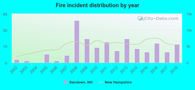 Based on the data from the years 2002 - 2018 the average number of fire incidents per year is 13. The highest number of fires - 39 took place in 2008, and the least - 0 in 2004. The data has a rising trend.
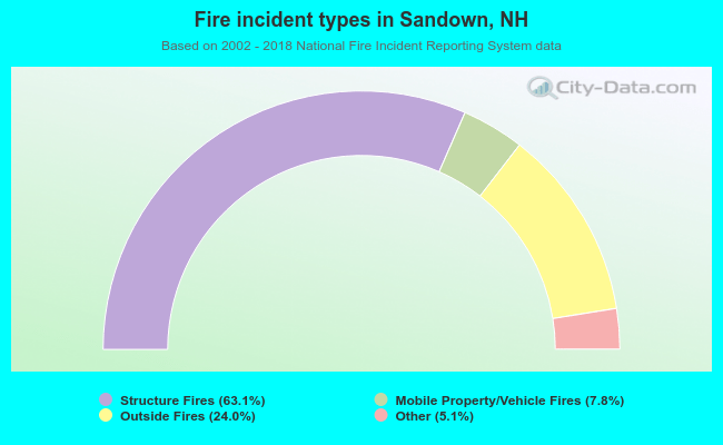 When looking into fire subcategories, the most incidents belonged to: Structure Fires (63.1%), and Outside Fires (24.0%).
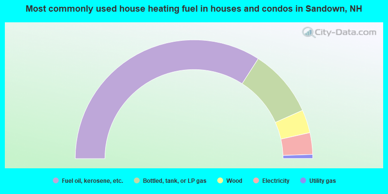
- 68.2%Fuel oil, kerosene, etc.
- 18.5%Bottled, tank, or LP gas
- 6.3%Wood
- 5.9%Electricity
- 1.1%Utility gas
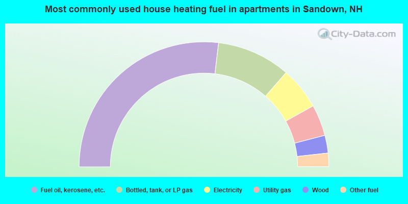
- 53.8%Fuel oil, kerosene, etc.
- 19.1%Bottled, tank, or LP gas
- 11.0%Electricity
- 8.1%Utility gas
- 4.6%Wood
- 3.5%Other fuel
Sandown compared to New Hampshire state average:
- Unemployed percentage significantly below state average.
- Black race population percentage significantly below state average.
- Hispanic race population percentage below state average.
- Foreign-born population percentage below state average.
- Renting percentage significantly below state average.
- Length of stay since moving in significantly above state average.
- Number of rooms per house significantly below state average.
- House age significantly below state average.
Sandown on our top lists:
- #10 on the list of "Top 101 cities with largest percentage of males in occupations: material recording, scheduling, dispatching, and distributing workers (population 5,000+)"
- #10 on the list of "Top 101 cities with largest percentage of males in industries: building material and garden equipment and supplies dealers (population 5,000+)"
- #23 on the list of "Top 101 cities with largest percentage of males in industries: computer and electronic products (population 5,000+)"
- #25 on the list of "Top 101 cities with largest percentage of females in industries: personal and laundry services (population 5,000+)"
- #31 on the list of "Top 101 cities with largest percentage of females in occupations: drafters, engineering, and mapping technicians (population 5,000+)"
- #31 on the list of "Top 101 cities with largest percentage of females in occupations: financial managers (population 5,000+)"
- #36 on the list of "Top 101 cities with largest percentage of females in industries: fuel dealers (population 5,000+)"
- #37 on the list of "Top 101 cities with largest percentage of females in industries: professional and commercial equipment and supplies merchant wholesalers (population 5,000+)"
- #37 on the list of "Top 101 cities with largest percentage of females in industries: pharmacies and drug stores (population 5,000+)"
- #37 on the list of "Top 101 cities with largest percentage of males in industries: miscellaneous manufacturing (population 5,000+)"
- #37 on the list of "Top 101 cities with largest percentage of males in industries: machinery, equipment, and supplies merchant wholesalers (population 5,000+)"
- #40 on the list of "Top 101 cities with largest percentage of females in industries: leather and allied products (population 5,000+)"
- #42 on the list of "Top 101 cities with largest percentage of females in industries: computer and electronic products (population 5,000+)"
- #43 on the list of "Top 101 cities with largest percentage of females in industries: radio, tv, and computer stores (population 5,000+)"
- #56 on the list of "Top 101 cities with largest percentage of males in occupations: financial clerks except bookkeeping, accounting, and auditing clerks (population 5,000+)"
- #56 on the list of "Top 101 cities with largest percentage of females in occupations: personal appearance workers (population 5,000+)"
- #56 on the list of "Top 101 cities with largest percentage of females in industries: wood products (population 5,000+)"
- #58 on the list of "Top 101 cities with largest percentage of males in industries: printing and related support activities (population 5,000+)"
- #59 on the list of "Top 101 cities with largest percentage of females in occupations: financial clerks except bookkeeping, accounting, and auditing clerks (population 5,000+)"
- #61 on the list of "Top 100 low-educated but high-earning cities (pop. 5,000+)"
- #9 on the list of "Top 101 counties with the largest decrease in the number of births per 1000 residents 2000-2006 to 2007-2013 (pop 50,000+)"
- #14 on the list of "Top 101 counties with the best general health status score of residents (1-5), 3 years of data"
- #16 on the list of "Top 101 counties with the lowest number of births per 1000 residents 2007-2013"
- #22 on the list of "Top 101 counties with the lowest Particulate Matter (PM10) Annual air pollution readings in 2012 (µg/m3)"
- #36 on the list of "Top 101 counties with the highest percentage of residents that visited a dentist within the past year"

|
|
Total of 91 patent applications in 2008-2024.