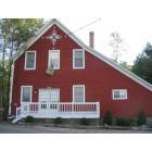
Saxeville, Wisconsin
Submit your own pictures of this town and show them to the world
- OSM Map
- General Map
- Google Map
- MSN Map
Population change since 2000: +1.2%
 |
| Males: 494 | |
| Females: 492 |
| Median resident age: | 48.7 years |
| Wisconsin median age: | 42.6 years |
Zip codes: 54965.
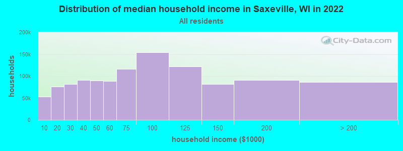
| Saxeville: | $64,146 |
| WI: | $70,996 |
Estimated per capita income in 2022: $42,943 (it was $20,514 in 2000)
Saxeville town income, earnings, and wages data
Estimated median house or condo value in 2022: $240,077 (it was $109,500 in 2000)
| Saxeville: | $240,077 |
| WI: | $252,800 |
Mean prices in 2022: all housing units: $214,925; detached houses: $223,954; townhouses or other attached units: $208,826; in 2-unit structures: $240,363; mobile homes: $67,729
Detailed information about poverty and poor residents in Saxeville, WI


- 96898.2%White alone
- 70.7%Hispanic
- 60.6%Two or more races
- 30.3%Asian alone
- 20.2%Black alone
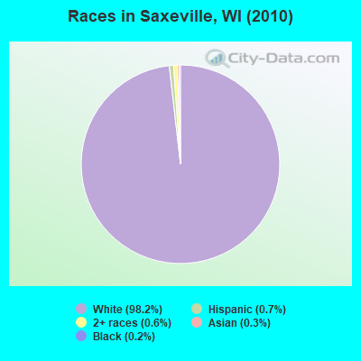
Races in Saxeville detailed stats: ancestries, foreign born residents, place of birth
 Recent articles from our blog. Our writers, many of them Ph.D. graduates or candidates, create easy-to-read articles on a wide variety of topics.

 | Escape From Wisconsin!!! (119 replies) |
Latest news from Saxeville, WI collected exclusively by city-data.com from local newspapers, TV, and radio stations
Ancestries: German (49.7%), English (12.3%), Irish (11.9%), Polish (7.9%), Norwegian (6.6%), Danish (5.5%).
Current Local Time: CST time zone
Elevation: 860 feet
Land area: 36.1 square miles.
Population density: 27 people per square mile (very low).
9 residents are foreign born
| This town: | 0.9% |
| Wisconsin: | 3.6% |
| Saxeville town: | 1.2% ($1,291) |
| Wisconsin: | 2.0% ($2,245) |
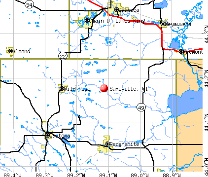
Nearest city with pop. 50,000+: Oshkosh, WI  (27.9 miles , pop. 62,916).
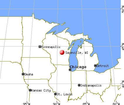
Nearest city with pop. 200,000+: Madison, WI (80.0 miles , pop. 208,054).
Nearest city with pop. 1,000,000+: Chicago, IL (177.6 miles , pop. 2,896,016).
Nearest cities:
), ), ), ), ), Latitude: 44.20 N, Longitude: 89.05 W
Area code commonly used in this area: 920

| Here: | 3.2% |
| Wisconsin: | 2.7% |
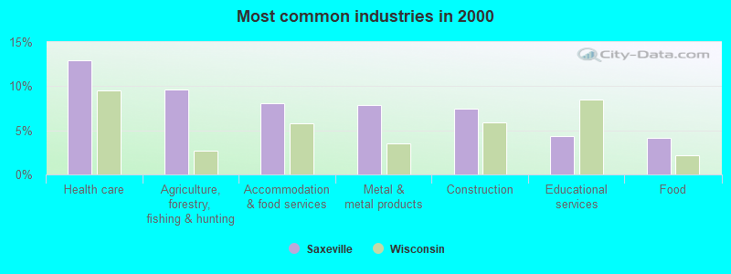
- Health care (12.9%)
- Agriculture, forestry, fishing & hunting (9.6%)
- Accommodation & food services (8.1%)
- Metal & metal products (7.9%)
- Construction (7.4%)
- Educational services (4.4%)
- Food (4.1%)
- Construction (13.4%)
- Agriculture, forestry, fishing & hunting (12.6%)
- Metal & metal products (11.5%)
- Food (6.7%)
- Health care (5.1%)
- Truck transportation (4.3%)
- Accommodation & food services (4.0%)

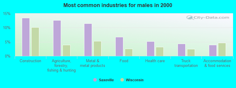
- Health care (22.4%)
- Accommodation & food services (13.2%)
- Finance & insurance (7.8%)
- Agriculture, forestry, fishing & hunting (5.9%)
- Educational services (5.4%)
- Food & beverage stores (4.9%)
- Social assistance (3.9%)
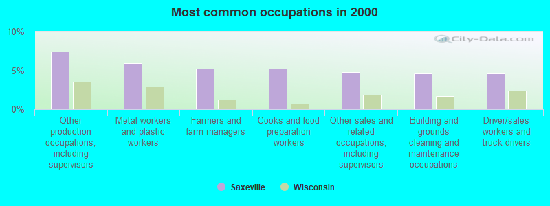
- Other production occupations, including supervisors (7.4%)
- Metal workers and plastic workers (5.9%)
- Farmers and farm managers (5.2%)
- Cooks and food preparation workers (5.2%)
- Other sales and related occupations, including supervisors (4.8%)
- Building and grounds cleaning and maintenance occupations (4.6%)
- Driver/sales workers and truck drivers (4.6%)
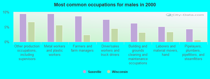
- Other production occupations, including supervisors (9.5%)
- Metal workers and plastic workers (9.5%)
- Farmers and farm managers (8.7%)
- Driver/sales workers and truck drivers (7.5%)
- Building and grounds cleaning and maintenance occupations (6.3%)
- Laborers and material movers, hand (5.1%)
- Pipelayers, plumbers, pipefitters, and steamfitters (4.3%)
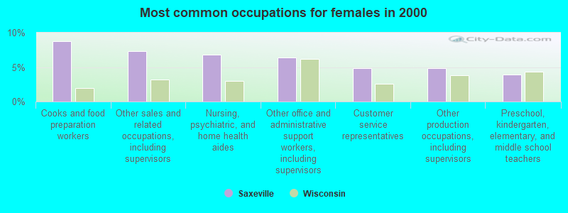
- Cooks and food preparation workers (8.8%)
- Other sales and related occupations, including supervisors (7.3%)
- Nursing, psychiatric, and home health aides (6.8%)
- Other office and administrative support workers, including supervisors (6.3%)
- Customer service representatives (4.9%)
- Other production occupations, including supervisors (4.9%)
- Preschool, kindergarten, elementary, and middle school teachers (3.9%)
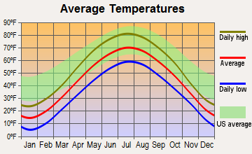
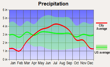
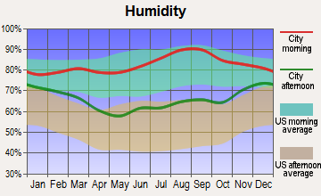
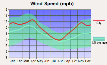
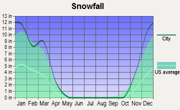
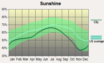
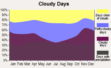
Average climate in Saxeville, Wisconsin
Based on data reported by over 4,000 weather stations
Tornado activity:
Saxeville-area historical tornado activity is slightly above Wisconsin state average. It is 44% greater than the overall U.S. average.
On 9/26/1951, a category F4 (max. wind speeds 207-260 mph) tornado 15.0 miles away from the Saxeville town center killed 6 people and injured 3 people and caused between $50,000 and $500,000 in damages.
On 4/27/1984, a category F4 tornado 17.4 miles away from the town center killed one person and injured 19 people and caused between $500,000 and $5,000,000 in damages.
Earthquake activity:
Saxeville-area historical earthquake activity is significantly above Wisconsin state average. It is 1% smaller than the overall U.S. average.On 6/28/2004 at 06:10:52, a magnitude 4.2 (4.2 MW, Depth: 6.2 mi, Class: Light, Intensity: IV - V) earthquake occurred 190.0 miles away from Saxeville center
On 4/18/2008 at 09:36:59, a magnitude 5.4 (5.1 MB, 4.8 MS, 5.4 MW, 5.2 MW, Class: Moderate, Intensity: VI - VII) earthquake occurred 402.4 miles away from Saxeville center
On 6/10/1987 at 23:48:54, a magnitude 5.1 (4.9 MB, 4.4 MS, 4.6 MS, 5.1 LG) earthquake occurred 377.2 miles away from Saxeville center
On 5/2/2015 at 16:23:07, a magnitude 4.2 (4.2 MW, Depth: 2.8 mi) earthquake occurred 227.8 miles away from the city center
On 2/10/2010 at 09:59:35, a magnitude 3.8 (3.8 MW, Depth: 6.2 mi, Class: Light, Intensity: II - III) earthquake occurred 157.1 miles away from the city center
On 4/18/2008 at 09:36:59, a magnitude 5.2 (5.2 MW, Depth: 8.9 mi) earthquake occurred 402.5 miles away from Saxeville center
Magnitude types: regional Lg-wave magnitude (LG), body-wave magnitude (MB), surface-wave magnitude (MS), moment magnitude (MW)
Natural disasters:
The number of natural disasters in Waushara County (8) is smaller than the US average (15).Major Disasters (Presidential) Declared: 6
Emergencies Declared: 2
Causes of natural disasters: Floods: 5, Storms: 4, Drought: 1, Hurricane: 1, Tornado: 1, Other: 1 (Note: some incidents may be assigned to more than one category).

Hospitals and medical centers near Saxeville:
- BETHANY HOME (Nursing Home, about 6 miles away; WAUPACA, WI)
- CRYSTAL RIVER NUR REHAB (Nursing Home, about 10 miles away; WAUPACA, WI)
- WILD ROSE MANOR (Nursing Home, about 10 miles away; WILD ROSE, WI)
- WILD ROSE COM MEM HOSPITAL, INC Critical Access Hospitals (about 10 miles away; WILD ROSE, WI)
- WILD ROSE COMMUNITY MEMORIAL HOSPITAL (Hospital, about 10 miles away; WILD ROSE, WI)
- RIVERSIDE MEDICAL CENTER, INC Critical Access Hospitals (about 10 miles away; WAUPACA, WI)
- WEYAUWEGA HEALTH CARE CTR (Nursing Home, about 10 miles away; WEYAUWEGA, WI)
Colleges/universities with over 2000 students nearest to Saxeville:
- University of Wisconsin-Oshkosh (about 28 miles; Oshkosh, WI; Full-time enrollment: 10,637)
- Fox Valley Technical College (about 30 miles; Appleton, WI; FT enrollment: 5,682)
- Lawrence University (about 33 miles; Appleton, WI; FT enrollment: 2,821)
- University of Wisconsin-Stevens Point (about 35 miles; Stevens Point, WI; FT enrollment: 9,089)
- Mid-State Technical College (about 39 miles; Wisconsin Rapids, WI; FT enrollment: 2,128)
- Moraine Park Technical College (about 43 miles; Fond du Lac, WI; FT enrollment: 3,079)
- Marian University (about 44 miles; Fond Du Lac, WI; FT enrollment: 2,045)
Points of interest:
Notable location: Saxeville - Springwater Fire Department (A). Display/hide its location on the map
Cemeteries: Hilltop Cemetery (1), Mount Calvary Cemetery (2). Display/hide their locations on the map
Lakes and reservoirs: Baitenger Lake (A), Big Cedar Lake (B), Timan Lake (C), Little Cedar Lake (D), Long Lake (E), Kristine Lake 2 (F), Mill Pond (G). Display/hide their locations on the map
Creeks: Austin Creek (A), Magdanz Creek (B). Display/hide their locations on the map
Drinking water stations with addresses in Saxeville and their reported violations in the past:
ST JOHNS LUTHERAN CH (Population served: 25, Groundwater):Past health violations:Past monitoring violations:
- MCL, Monthly (TCR) - In AUG-2005, Contaminant: Coliform. Follow-up actions: St Public Notif requested (SEP-12-2005), St Boil Water Order (SEP-12-2005), St Violation/Reminder Notice (SEP-12-2005), St Public Notif received (SEP-26-2005), St Compliance achieved (OCT-04-2005)
- Monitoring, Check/Repeat/Confirmation - Between AUG-30-2005 and SEP-30-2005, Contaminant: Nitrate. Follow-up actions: St Public Notif requested (OCT-19-2005), St Violation/Reminder Notice (OCT-19-2005), St Compliance achieved (NOV-03-2005)
Drinking water stations with addresses in Saxeville that have no violations reported:
- SAXEVILLE COMMUNITY CH (Population served: 25, Primary Water Source Type: Groundwater)
| This town: | 2.3 people |
| Wisconsin: | 2.4 people |
| This town: | 73.2% |
| Whole state: | 64.4% |
| This town: | 6.7% |
| Whole state: | 7.3% |
Likely homosexual households (counted as self-reported same-sex unmarried-partner households)
- Lesbian couples: 0.5% of all households
- Gay men: 0.2% of all households
| This town: | 9.2% |
| Whole state: | 8.7% |
| This town: | 5.0% |
| Whole state: | 3.7% |
For population 15 years and over in Saxeville:
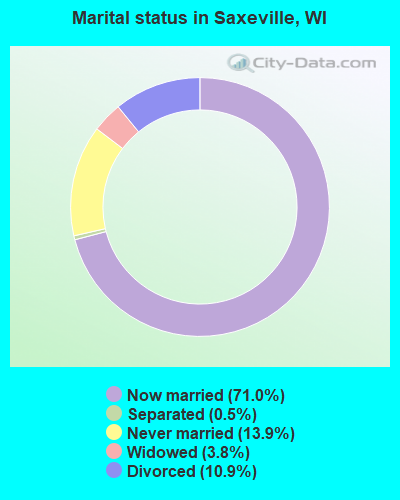
- Never married: 13.9%
- Now married: 71.0%
- Separated: 0.5%
- Widowed: 3.8%
- Divorced: 10.9%
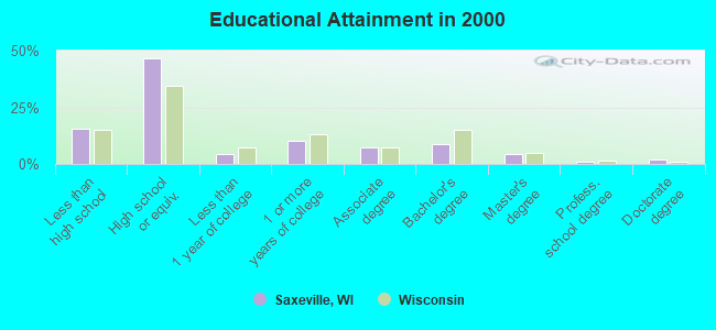
For population 25 years and over in Saxeville:
- High school or higher: 84.5%
- Bachelor's degree or higher: 15.9%
- Graduate or professional degree: 7.3%
- Unemployed: 5.2%
- Mean travel time to work (commute): 36.1 minutes
| Here: | 10.4 |
| Wisconsin average: | 11.0 |
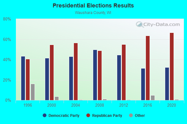
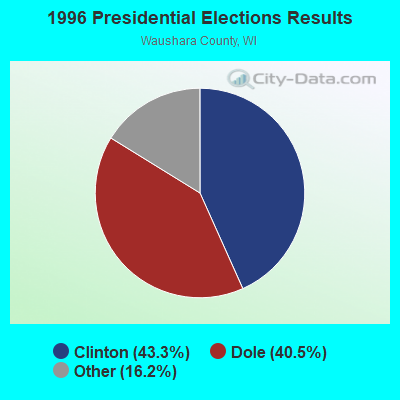
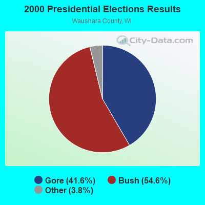
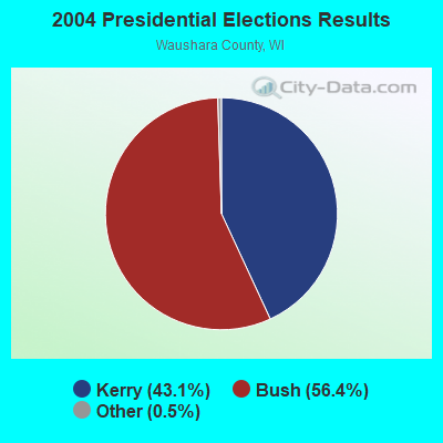
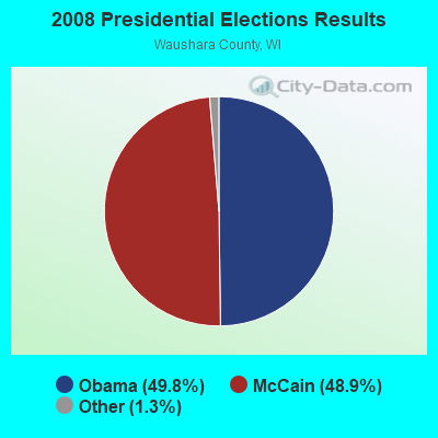
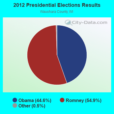
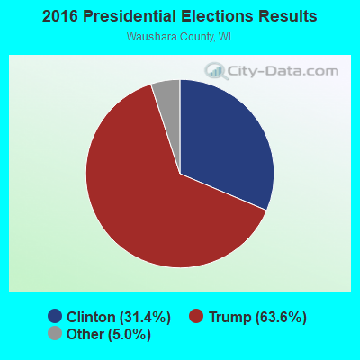
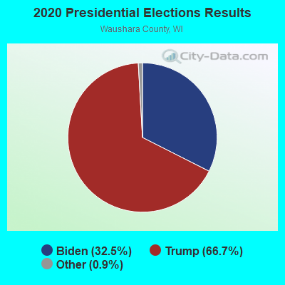
Graphs represent county-level data. Detailed 2008 Election Results
Religion statistics for Saxeville, WI (based on Waushara County data)
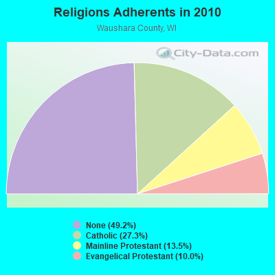
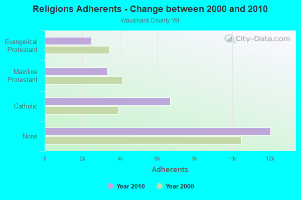
| Religion | Adherents | Congregations |
|---|---|---|
| Catholic | 6,687 | 4 |
| Mainline Protestant | 3,305 | 16 |
| Evangelical Protestant | 2,450 | 20 |
| Other | 3 | 1 |
| None | 12,051 | - |
Food Environment Statistics:
| Waushara County: | 3.64 / 10,000 pop. |
| State: | 1.86 / 10,000 pop. |
| Here: | 4.86 / 10,000 pop. |
| Wisconsin: | 4.12 / 10,000 pop. |
| This county: | 8.50 / 10,000 pop. |
| Wisconsin: | 8.64 / 10,000 pop. |
| Waushara County: | 8.4% |
| Wisconsin: | 7.6% |
| Here: | 28.1% |
| Wisconsin: | 27.5% |
| This county: | 17.9% |
| Wisconsin: | 13.0% |
Strongest AM radio stations in Saxeville:
- WDUX (800 AM; 5 kW; WAUPACA, WI; Owner: LAIRD BROADCASTING COMPANY, INC.)
- WNAM (1280 AM; 50 kW; NEENAH-MENASHA, WI; Owner: CUMULUS LICENSING CORP.)
- WSPT (1010 AM; 50 kW; STEVENS POINT, WI)
- WHBY (1150 AM; 25 kW; KIMBERLY, WI; Owner: WOODWARD COMMUNICATIONS, INC.)
- WSAU (550 AM; 20 kW; WAUSAU, WI; Owner: WRIG, INC.)
- WTMJ (620 AM; 50 kW; MILWAUKEE, WI; Owner: JOURNAL BROADCAST CORPORATION)
- WRPN (1600 AM; 5 kW; RIPON, WI)
- WISN (1130 AM; 50 kW; MILWAUKEE, WI; Owner: CAPSTAR TX LIMITED PARTNERSHIP)
- WFCL (1380 AM; 4 kW; CLINTONVILLE, WI; Owner: RESULTS BROADCASTING CORP.)
- WTAQ (1360 AM; 10 kW; GREEN BAY, WI; Owner: MIDWEST COMMUNICATIONS, INC.)
- WSCR (670 AM; 50 kW; CHICAGO, IL; Owner: INFINITY BROADCASTING OPERATIONS, INC.)
- WGN (720 AM; 50 kW; CHICAGO, IL; Owner: WGN CONTINENTAL BROADCASTING CO.)
- WRIG (1390 AM; 10 kW; SCHOFIELD, WI; Owner: WRIG, INC.)
Strongest FM radio stations in Saxeville:
- WAUH (102.3 FM; WAUTOMA, WI; Owner: HOMETOWN BROADCASTING LLC)
- WDUX-FM (92.7 FM; WAUPACA, WI; Owner: LAIRD BROADCASTING COMPANY, INC.)
- WAPL-FM (105.7 FM; APPLETON, WI; Owner: WOODWARD COMMUNICATIONS, INC.)
- WBJZ (104.7 FM; BERLIN, WI; Owner: CAXAMBAS CORPORATION)
- WPKR (99.5 FM; OMRO, WI; Owner: MIDWEST DIMENSIONS, INC.)
- WGLX-FM (103.3 FM; WISCONSIN RAPIDS, WI; Owner: WISCONSIN RAPIDS BROADCASTING, LLC)
- WNCY-FM (100.3 FM; NEENAH-MENASHA, WI; Owner: MIDWEST COMMUNICATIONS, INC.)
- WROE (94.3 FM; NEENAH-MENASHA, WI; Owner: MIDWEST COMMUNICATIONS, INC.)
TV broadcast stations around Saxeville:
- WMMF-TV (Channel 68; FOND DU LAC, WI; Owner: PAPPAS TELECASTING OF WISCONSIN, A CALIFORNIA LTD PARTNRSHP)
- W66DC (Channel 66; WAUPACA, WI; Owner: TRINITY BROADCASTING NETWORK)
- W24BV (Channel 24; WHITING, WI; Owner: MS COMMUNICATIONS, LLC)
- W60CI (Channel 60; WHITING, WI; Owner: MS COMMUNICATIONS, LLC)
- W64AU (Channel 64; ADAMS, WI; Owner: STATE OF WISCONSIN - EDUCATIONAL COMMUNICATIONS BOARD)
- W23BL (Channel 23; TRAVERSE CITY, MI; Owner: MS COMMUNICATIONS, LLC)
Saxeville fatal accident list:
- National Bridge Inventory (NBI) Statistics
- 1Number of bridges
- 3ft / 1.3mTotal length
- 783Total average daily traffic
- 78Total average daily truck traffic
- 861Total future (year 2040) average daily traffic
FCC Registered Antenna Towers:
5- Steven Schneider, N6071 26th Road (Lat: 44.201056 Lon: -89.099444), Type: 97.5, Overall height: 91.4 m, Registrant: Wireless Applications Corporation, Fcc@wacorp.Net, , Belle-vue, Phone: (425) 643-5000
- Steven Schneider, N6071 26th Road (Lat: 44.201056 Lon: -89.099444), Type: 97.5, Overall height: 91.4 m, Registrant: Wireless Applications Corporation, Fcc@wacorp.Net, , Belle-vue, Phone: (425) 643-5000
- Craig B Royal, N6071 26th Road (Lat: 44.201056 Lon: -89.099444), Type: 97.5, Overall height: 91.4 m, Registrant: Tv-6 Hc Towers LLC, Royal@towerventures.Com, , Memph-is, Phone: (901) 794-9494
- Leslie N Nixon, N6071 26th Road (Lat: 44.201056 Lon: -89.099444), Type: 97.5, Structure height: 55137 m, Overall height: 91.4 m, Registrant: Global Tower, LLC, Fcc-Contact@gtpsites.Com, , Boca -Raton, Phone: (561) 995-0320
- Kristen Cesana, N6071 26th Road (Lat: 44.201056 Lon: -89.099444), Type: 97.5, Structure height: 55137 m, Overall height: 91.4 m, Registrant: American Towers, LLC., Faa-Fcc@americantower.Com, , Wobur-n, Phone: (678) 265-6770
FCC Registered Microwave Towers:
3- SAXEVILLE, N6071 26th Road (Lat: 44.201056 Lon: -89.099444), Type: Tower, Structure height: 91.4 m, Overall height: 97.5 m, Call Sign: WQKZ808,
Assigned Frequencies: 11075.0 MHz, 11075.0 MHz, 11075.0 MHz, 11075.0 MHz, 11075.0 MHz, Grant Date: 01/27/2020, Expiration Date: 11/05/2029, Certifier: Dwayne Latzke, Registrant: Bug Tussel Wireless, LLC, Green Bay, WI 54305, Phone: (920) 202-2390, Fax: (920) 884-0836, Email:
- SAXEVILLE, N6071 26th Road (Lat: 44.201056 Lon: -89.099444), Type: Tower, Structure height: 91.4 m, Overall height: 97.5 m, Call Sign: WQOT627,
Assigned Frequencies: 10755.0 MHz, 10855.0 MHz, 10755.0 MHz, 10755.0 MHz, 10755.0 MHz, 10755.0 MHz, 10755.0 MHz, 10755.0 MHz, Grant Date: 02/16/2022, Expiration Date: 01/26/2032, Certifier: David R Peterson, Registrant: Waushara County Sheriff, 430 E Division St, Wautoma, WI 54982, Phone: (920) 787-0422, Fax: (920) 787-7685, Email:
- SAXEVILLE, N6071 26th Road (Lat: 44.201056 Lon: -89.099444), Type: Gtower, Structure height: 91.4 m, Overall height: 97.5 m, Call Sign: WQPL548,
Assigned Frequencies: 6137.92 MHz, Grant Date: 05/17/2022, Expiration Date: 06/20/2032, Certifier: Steven T Campbell, Registrant: Wilkinson Barker Knauer, LLP, 1800 M Street Nw, Suite 800n, Washington, DC 20036, Phone: (202) 383-3420, Fax: (202) 783-5851, Email:
| Most common first names in Saxeville, WI among deceased individuals | ||
| Name | Count | Lived (average) |
|---|---|---|
| Frank | 4 | 75.2 years |
| George | 2 | 85.0 years |
| Glen | 2 | 74.0 years |
| Irene | 2 | 92.0 years |
| Most common last names in Saxeville, WI among deceased individuals | ||
| Last name | Count | Lived (average) |
|---|---|---|
| Jorgensen | 3 | 84.3 years |
| Forrest | 3 | 80.3 years |
| Jensen | 2 | 76.1 years |
| Erdman | 2 | 66.0 years |
| Kaniuga | 2 | 69.0 years |
| Fiedler | 2 | 83.0 years |
| Jenks | 2 | 83.0 years |
| Larson | 2 | 84.0 years |
| Petersen | 2 | 65.0 years |
| Peterson | 2 | 81.0 years |
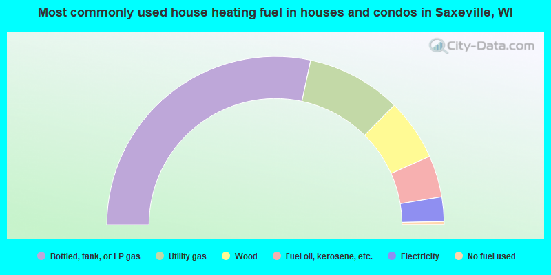
- 56.7%Bottled, tank, or LP gas
- 18.2%Utility gas
- 11.8%Wood
- 8.0%Fuel oil, kerosene, etc.
- 4.7%Electricity
- 0.6%No fuel used
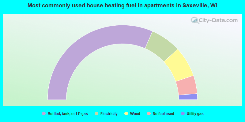
- 63.2%Bottled, tank, or LP gas
- 13.2%Electricity
- 13.2%Wood
- 7.9%No fuel used
- 2.6%Utility gas
Saxeville compared to Wisconsin state average:
- Unemployed percentage below state average.
- Black race population percentage significantly below state average.
- Hispanic race population percentage significantly below state average.
- Median age above state average.
- Foreign-born population percentage significantly below state average.
- Renting percentage significantly below state average.
- Length of stay since moving in significantly above state average.
- Number of rooms per house significantly below state average.
- House age significantly below state average.
- Number of college students below state average.