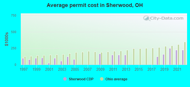
Estimated median house or condo value in 2022: $264,613 (it was $137,500 in 2000)
Sherwood:
$264,613
OH:
$204,100
Mean prices in 2022:all housing units: $194,167; detached houses: $201,316; townhouses or other attached units: $206,933; in 2-unit structures: $208,659; in 5-or-more-unit structures: $202,920; mobile homes: $33,097March 2022 cost of living index in Sherwood: 93.7 (less than average, U.S. average is 100)
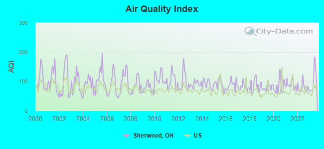
Air Quality Index (AQI) level in 2023 was 100. This is worse than average.
City:
100
U.S.:
73
Carbon Monoxide (CO) [ppm] level in 2023 was 0.138. This is significantly better than average.Closest monitor was 6.4 miles away from the city center.
City:
0.138
U.S.:
0.251
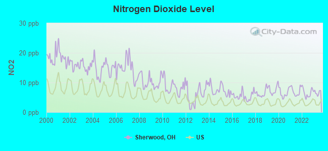
Nitrogen Dioxide (NO2) [ppb] level in 2023 was 6.63. This is worse than average.Closest monitor was 4.9 miles away from the city center.
City:
6.63
U.S.:
5.11
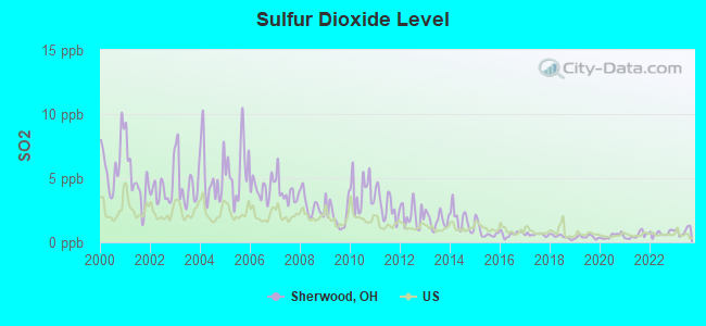
Sulfur Dioxide (SO2) [ppb] level in 2023 was 0.893. This is significantly better than average.Closest monitor was 4.9 miles away from the city center.
City:
0.893
U.S.:
1.515
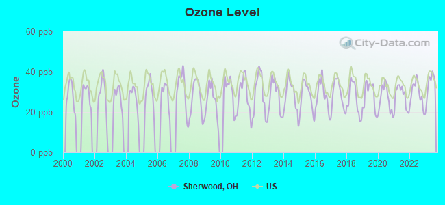
Ozone [ppb] level in 2023 was 33.6. This is about average.Closest monitor was 6.2 miles away from the city center.
City:
33.6
U.S.:
33.3
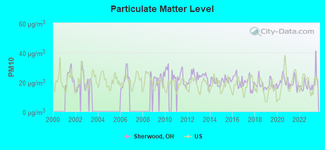
Particulate Matter (PM10) [µg/m3] level in 2023 was 21.0. This is about average.Closest monitor was 4.9 miles away from the city center.
City:
21.0
U.S.:
19.2
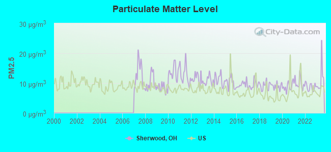
Particulate Matter (PM2.5) [µg/m3] level in 2023 was 11.3. This is worse than average.Closest monitor was 4.9 miles away from the city center.
City:
11.3
U.S.:
8.1
Tornado activity:
Sherwood-area historical tornado activity is slightly above Ohio state average. It is 57% greater than the overall U.S. average.
On 4/3/1974, a category F5 (max. wind speeds 261-318 mph) tornado 16.9 miles away from the Sherwood place center killed 3 peopleand injured 210 people.
On 4/23/1968, a category F4 (max. wind speeds 207-260 mph) tornado 5.1 miles away from the place center killed one personand injured 33 peopleand causedbetween $500,000 and $5,000,000 in damages.
Earthquake activity:
Sherwood-area historical earthquake activity is significantly above Ohio state average. It is 45% greater than the overall U.S. average.
On 7/27/1980 at 18:52:21, a magnitude 5.2 (5.1 MB, 4.7 MS, 5.0 UK, 5.2 UK, Class: Moderate, Intensity: VI - VII) earthquake occurred 65.2 miles away from Sherwood center On 4/18/2008 at 09:36:59, a magnitude 5.4 (5.1 MB, 4.8 MS, 5.4 MW, 5.2 MW) earthquake occurred 194.9 miles away from the city center On 9/7/1988 at 02:28:09, a magnitude 4.6 (4.5 MB, 4.6 LG, Class: Light, Intensity: IV - V) earthquake occurred 70.5 miles away from the city center On 4/18/2008 at 09:36:59, a magnitude 5.2 (5.2 MW, Depth: 8.9 mi) earthquake occurred 194.9 miles away from Sherwood center On 6/10/1987 at 23:48:54, a magnitude 5.1 (4.9 MB, 4.4 MS, 4.6 MS, 5.1 LG) earthquake occurred 190.2 miles away from the city center On 6/18/2002 at 17:37:15, a magnitude 5.0 (4.3 MB, 4.6 MW, 5.0 LG) earthquake occurred 199.9 miles away from the city center Magnitude types: regional Lg-wave magnitude (LG), body-wave magnitude (MB), surface-wave magnitude (MS), moment magnitude (MW)
Natural disasters:
The number of natural disasters in Defiance County (5) is a lot smaller than the US average (15). Major Disasters (Presidential) Declared: 1 Emergencies Declared: 3
Causes of natural disasters: Snowstorms: 2, Blizzard: 1, Flood: 1, Hurricane: 1, Storm: 1, Other: 1 (Note: some incidents may be assigned to more than one category).
Hospitals and medical centers near Sherwood:
MOUNT WASHINGTON CARE CENTER (Nursing Home, about 1 miles away; CINCINNATI, OH)
MERCY HOSPITAL ANDERSON Acute Care Hospitals (about 1 miles away; CINCINNATI, OH)
DAVITA - ANDERSON DIALYSIS (Dialysis Facility, about 1 miles away; ANDERSON, OH)
RESIDENCE AT SALEM WOODS, THE (Nursing Home, about 2 miles away; CINCINNATI, OH)
SUPERIOR CARE PLUS, LLC (Home Health Center, about 3 miles away; CINCINNATI, OH)
ANDERSON, THE (Nursing Home, about 3 miles away; CINCINNATI, OH)
UNITED HOME CARE CLERMONT *CLOSED* (Home Health Center, about 4 miles away; CINCINNATI, OH)
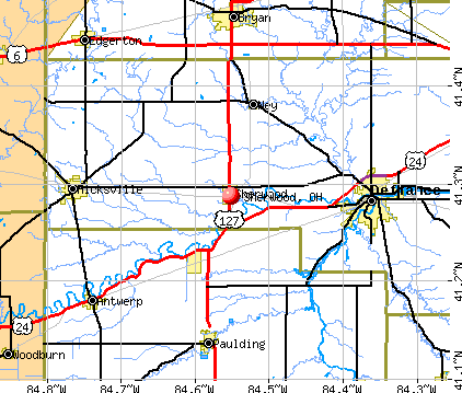
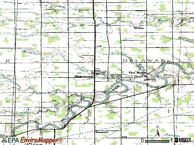
Sherwood, Ohio is located in northwest Ohio, Defiance County--not anywhere near Cincinnati. Your map is incorrect.
Sherwood Ohio is located in N/W Ohio. The map is wrong on this page. It is located 1/2 way between Paulding, to the south, and Bryan, to the north, right on St Rt 127.
The map is incorrect. Sherwood ohio is in the northwest corner of Ohio.
Defiance County has a predicted average indoor radon screening level between 2 and 4 pCi/L (pico curies per liter) - Moderate Potential
Drinking water stations with addresses in Sherwood and their reported violations in the past:
ST JOHN LUTHERAN CHURCH-SHERWOOD (Population served: 180, Groundwater):
Past health violations:
MCL, Monthly (TCR) - Between JUL-2009 and SEP-2009, Contaminant: Coliform. Follow-up actions: St Public Notif requested (OCT-09-2009), St Violation/Reminder Notice (OCT-09-2009), St Public Notif received (OCT-23-2009), St Compliance achieved (JUN-11-2010)
Past monitoring violations:
One routine major monitoring violation
Average household size:
This place:
2.9 people
Ohio:
2.5 people
Percentage of family households:
This place:
83.8%
Whole state:
67.6%
Percentage of households with unmarried partners:
This place:
3.0%
Whole state:
5.2%
Likely homosexual households (counted as self-reported same-sex unmarried-partner households)
Lesbian couples: 0.4% of all households
Gay men: 0.2% of all households
Residents with income below the poverty level in 2009:
This place:
1.5%
Whole state:
10.6%
Residents with income below 50% of the poverty level in 2009:
This place:
1.1%
Whole state:
4.8%
Banks with branches in Sherwood (2011 data):
The Sherwood State Bank: at 105 North Harrison Street, branch established on 1945/01/08. Info updated 2012/01/04: Bank assets: $50.8 mil, Deposits: $43.0 mil, local headquarters, positive income, 3 total offices, Holding Company: Sherwood Banc Corporation
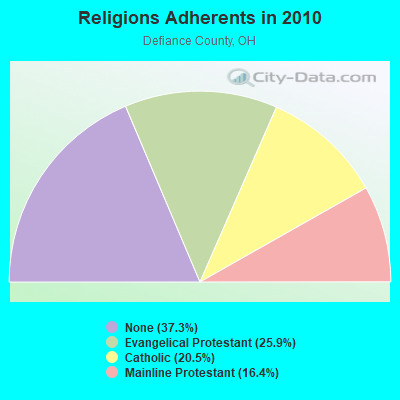
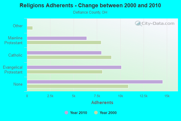
Religion statistics for Sherwood, OH (based on Defiance County data)
Religion
Adherents
Congregations
Evangelical Protestant
10,104
46
Catholic
7,984
5
Mainline Protestant
6,394
23
Other
3
-
None
14,552
-
Source: Clifford Grammich, Kirk Hadaway, Richard Houseal, Dale E.Jones, Alexei Krindatch, Richie Stanley and Richard H.Taylor. 2012. 2010 U.S.Religion Census: Religious Congregations & Membership Study. Association of Statisticians of American Religious Bodies. Jones, Dale E., et al. 2002. Congregations and Membership in the United States 2000. Nashville, TN: Glenmary Research Center. Graphs represent county-level data
Food Environment Statistics:
Number of grocery stores: 5
Defiance County:
1.29 / 10,000 pop.
State:
1.89 / 10,000 pop.
Number of supercenters and club stores: 2
Defiance County:
0.52 / 10,000 pop.
Ohio:
0.13 / 10,000 pop.
Number of convenience stores (no gas): 3
Defiance County:
0.78 / 10,000 pop.
State:
1.25 / 10,000 pop.
Number of convenience stores (with gas): 18
This county:
4.66 / 10,000 pop.
Ohio:
2.93 / 10,000 pop.
Number of full-service restaurants: 26
Defiance County:
6.73 / 10,000 pop.
State:
6.25 / 10,000 pop.
Adult diabetes rate:
Here:
10.4%
Ohio:
10.3%
Adult obesity rate:
Defiance County:
28.6%
Ohio:
29.1%
Low-income preschool obesity rate:
Defiance County:
12.8%
Ohio:
11.9%
Local government employment and payroll (March 2022)
1 Km S Hwy 18 1 Km W Rosebrook Rd 1 Km Ne (Lat: 41.291167 Lon: -84.538000), Call Sign: KPE980, Assigned Frequencies: 455.980 MHz, Grant Date: 07/11/1995, Expiration Date: 10/01/1996, Cancellation Date: 09/24/2000, Registrant: Lima Broadcasting Co, 667 W Market St, Lima, OH 45801, Phone: (419) 223-2060
FCC Registered Broadcast Land Mobile Towers:
3
4 Mi S Of Hwy 18 (Lat: 41.291167 Lon: -84.538000), Type: Tower, Structure height: 175 m, Overall height: 182 m, Call Sign: KNNI577, Licensee ID: L00050824, Assigned Frequencies: 462.475 MHz, 462.475 MHz, Grant Date: 12/05/2000, Expiration Date: 01/31/2011, Cancellation Date: 04/17/2007, Certifier: Michael R Comisky, Registrant: Sprint Communications Company, LP, 2001 Edmund Halley Drive, Reston, VA 20191, Phone: (703) 433-4000, Fax: (703) 433-4035
200 N. Harrison St (Lat: 41.287194 Lon: -84.553583), Type: Bant, Structure height: 12.1 m, Overall height: 15.2 m, Call Sign: WQRH267, Assigned Frequencies: 173.262 MHz, Grant Date: 05/13/2013, Expiration Date: 05/13/2023, Cancellation Date: 07/15/2023, Certifier: John D Kosiur, Registrant: Village Of Sherwood Ohio, 200 N. Harrison St, Sherwood, OH 43556, Phone: (419) 899-2145, Fax: (419) 899-2148, Email:
Rosebrook Rd (Lat: 41.291139 Lon: -84.538000), Overall height: 176.8 m, Call Sign: WLP745, Licensee ID: L01445394, Assigned Frequencies: 948.500 MHz, Grant Date: 07/13/1990, Expiration Date: 10/01/2012, Cancellation Date: 01/27/2012, Registrant: Citicasters Licenses, Inc., 2625 S. Memorial Drive Suite A, Tulsa, OK 74129
FCC Registered Amateur Radio Licenses:
5
Call Sign: N8FOK, Previous Call Sign: KA8LEB, Licensee ID: L00673089, Grant Date: 11/16/2023, Expiration Date: 11/16/2033, Certifier: E Christine Ballard, Registrant: E Christine Ballard, 15315 Roland Road, Sherwood, OH 43556
Call Sign: WD8JVV, Licensee ID: L01375960, Grant Date: 01/11/2018, Expiration Date: 03/04/2028, Certifier: Edward C Ballard Jr, Registrant: Edward C Ballard Jr, 15315 Roland Rd., Sherwood, OH 43556-9770
Call Sign: KD8PSW, Licensee ID: L01625433, Grant Date: 01/19/2021, Expiration Date: 03/18/2031, Certifier: Charlie D Stollings Jr, Registrant: Charlie D Stollings Jr, 300 East Pearl St, Sherwood, OH 43556
Call Sign: KD8PSY, Licensee ID: L01625435, Grant Date: 02/24/2021, Expiration Date: 03/18/2031, Certifier: Rex L Weible, Registrant: Rex L Weible, Sherwood, OH 43556
Call Sign: KD8TCK, Licensee ID: L01734172, Grant Date: 09/14/2012, Expiration Date: 09/14/2022, Certifier: Douglas D Polter, Registrant: Douglas D Polter, 6567 Behnfeldt Road, Sherwood, OH 43556
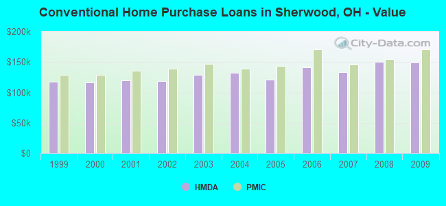
Home Mortgage Disclosure Act Aggregated Statistics For Year 2009 (Based on 2 partial tracts)
A) FHA, FSA/RHS & VA Home Purchase Loans
B) Conventional Home Purchase Loans
C) Refinancings
D) Home Improvement Loans
F) Non-occupant Loans on < 5 Family Dwellings (A B C & D)
Number
Average Value
Number
Average Value
Number
Average Value
Number
Average Value
Number
Average Value
LOANS ORIGINATED
17
$144,416
23
$149,705
129
$143,590
3
$47,237
2
$106,510
APPLICATIONS APPROVED, NOT ACCEPTED
1
$180,450
1
$230,500
5
$131,398
2
$54,470
0
$0
APPLICATIONS DENIED
1
$152,560
2
$115,075
29
$154,301
3
$50,477
1
$93,140
APPLICATIONS WITHDRAWN
1
$95,740
1
$250,030
11
$154,717
1
$7,310
0
$0
FILES CLOSED FOR INCOMPLETENESS
1
$89,270
0
$0
5
$134,804
0
$0
0
$0
Aggregated Statistics For Year 2008 (Based on 2 partial tracts)
A) FHA, FSA/RHS & VA Home Purchase Loans
B) Conventional Home Purchase Loans
C) Refinancings
D) Home Improvement Loans
E) Loans on Dwellings For 5+ Families
F) Non-occupant Loans on < 5 Family Dwellings (A B C & D)
Number
Average Value
Number
Average Value
Number
Average Value
Number
Average Value
Number
Average Value
Number
Average Value
LOANS ORIGINATED
12
$142,502
28
$150,738
59
$149,197
7
$26,501
1
$129,090
5
$95,996
APPLICATIONS APPROVED, NOT ACCEPTED
0
$0
2
$152,915
6
$161,960
3
$12,240
0
$0
1
$111,410
APPLICATIONS DENIED
1
$82,610
2
$84,955
20
$150,228
4
$22,015
0
$0
1
$91,010
APPLICATIONS WITHDRAWN
0
$0
4
$140,725
9
$130,158
0
$0
0
$0
1
$117,750
FILES CLOSED FOR INCOMPLETENESS
0
$0
1
$70,450
2
$127,680
0
$0
0
$0
1
$46,520
Aggregated Statistics For Year 2007 (Based on 2 partial tracts)
A) FHA, FSA/RHS & VA Home Purchase Loans
B) Conventional Home Purchase Loans
C) Refinancings
D) Home Improvement Loans
F) Non-occupant Loans on < 5 Family Dwellings (A B C & D)
Number
Average Value
Number
Average Value
Number
Average Value
Number
Average Value
Number
Average Value
LOANS ORIGINATED
5
$142,066
49
$132,847
46
$129,249
11
$35,248
4
$112,040
APPLICATIONS APPROVED, NOT ACCEPTED
0
$0
3
$100,057
9
$136,719
1
$13,910
1
$78,390
APPLICATIONS DENIED
1
$123,630
4
$158,848
21
$142,180
6
$32,335
2
$131,575
APPLICATIONS WITHDRAWN
0
$0
3
$145,643
7
$129,453
0
$0
1
$120,960
FILES CLOSED FOR INCOMPLETENESS
0
$0
0
$0
4
$148,892
0
$0
0
$0
Aggregated Statistics For Year 2006 (Based on 2 partial tracts)
A) FHA, FSA/RHS & VA Home Purchase Loans
B) Conventional Home Purchase Loans
C) Refinancings
D) Home Improvement Loans
F) Non-occupant Loans on < 5 Family Dwellings (A B C & D)
Number
Average Value
Number
Average Value
Number
Average Value
Number
Average Value
Number
Average Value
LOANS ORIGINATED
3
$145,467
64
$141,263
61
$116,054
9
$42,150
9
$136,031
APPLICATIONS APPROVED, NOT ACCEPTED
0
$0
5
$102,452
9
$102,288
3
$33,477
2
$75,670
APPLICATIONS DENIED
0
$0
5
$98,446
27
$127,109
6
$44,177
2
$92,335
APPLICATIONS WITHDRAWN
2
$125,540
5
$129,824
21
$136,415
2
$61,190
2
$141,300
FILES CLOSED FOR INCOMPLETENESS
0
$0
2
$64,840
5
$145,288
0
$0
1
$61,440
Aggregated Statistics For Year 2005 (Based on 2 partial tracts)
A) FHA, FSA/RHS & VA Home Purchase Loans
B) Conventional Home Purchase Loans
C) Refinancings
D) Home Improvement Loans
F) Non-occupant Loans on < 5 Family Dwellings (A B C & D)
Number
Average Value
Number
Average Value
Number
Average Value
Number
Average Value
Number
Average Value
LOANS ORIGINATED
6
$149,295
74
$120,540
73
$117,434
12
$51,736
8
$102,341
APPLICATIONS APPROVED, NOT ACCEPTED
0
$0
3
$94,113
12
$120,974
2
$36,445
0
$0
APPLICATIONS DENIED
1
$64,680
4
$129,575
35
$133,307
10
$35,288
3
$131,567
APPLICATIONS WITHDRAWN
0
$0
6
$152,213
28
$134,916
3
$106,037
3
$112,787
FILES CLOSED FOR INCOMPLETENESS
0
$0
1
$141,390
4
$128,338
1
$55,350
0
$0
Aggregated Statistics For Year 2004 (Based on 2 partial tracts)
A) FHA, FSA/RHS & VA Home Purchase Loans
B) Conventional Home Purchase Loans
C) Refinancings
D) Home Improvement Loans
F) Non-occupant Loans on < 5 Family Dwellings (A B C & D)
Number
Average Value
Number
Average Value
Number
Average Value
Number
Average Value
Number
Average Value
LOANS ORIGINATED
6
$144,615
59
$132,178
93
$118,971
13
$40,128
6
$103,573
APPLICATIONS APPROVED, NOT ACCEPTED
0
$0
6
$121,950
14
$107,343
1
$15,700
2
$126,155
APPLICATIONS DENIED
1
$104,040
3
$110,493
29
$131,110
6
$27,463
1
$111,150
APPLICATIONS WITHDRAWN
1
$123,980
4
$95,655
19
$115,914
3
$42,917
0
$0
FILES CLOSED FOR INCOMPLETENESS
0
$0
0
$0
8
$134,200
1
$34,760
0
$0
Aggregated Statistics For Year 2003 (Based on 2 partial tracts)
A) FHA, FSA/RHS & VA Home Purchase Loans
B) Conventional Home Purchase Loans
C) Refinancings
D) Home Improvement Loans
F) Non-occupant Loans on < 5 Family Dwellings (A B C & D)
Number
Average Value
Number
Average Value
Number
Average Value
Number
Average Value
Number
Average Value
LOANS ORIGINATED
8
$130,089
57
$128,745
319
$118,535
15
$29,329
8
$113,950
APPLICATIONS APPROVED, NOT ACCEPTED
0
$0
5
$106,588
26
$112,617
2
$13,545
1
$92,160
APPLICATIONS DENIED
1
$39,280
7
$109,871
39
$120,639
7
$34,963
3
$126,770
APPLICATIONS WITHDRAWN
0
$0
4
$146,300
26
$121,373
2
$49,355
2
$118,045
FILES CLOSED FOR INCOMPLETENESS
0
$0
1
$155,400
9
$135,400
0
$0
0
$0
Aggregated Statistics For Year 2002 (Based on 2 partial tracts)
A) FHA, FSA/RHS & VA Home Purchase Loans
B) Conventional Home Purchase Loans
C) Refinancings
D) Home Improvement Loans
E) Loans on Dwellings For 5+ Families
F) Non-occupant Loans on < 5 Family Dwellings (A B C & D)
Number
Average Value
Number
Average Value
Number
Average Value
Number
Average Value
Number
Average Value
Number
Average Value
LOANS ORIGINATED
8
$119,091
59
$118,160
218
$118,586
12
$24,222
1
$201,260
9
$99,332
APPLICATIONS APPROVED, NOT ACCEPTED
1
$73,200
4
$131,755
26
$91,466
3
$26,540
0
$0
0
$0
APPLICATIONS DENIED
0
$0
5
$118,688
26
$119,201
8
$12,494
0
$0
1
$83,130
APPLICATIONS WITHDRAWN
1
$101,170
2
$156,320
19
$113,119
2
$5,120
0
$0
2
$85,970
FILES CLOSED FOR INCOMPLETENESS
1
$92,570
0
$0
8
$97,802
0
$0
0
$0
0
$0
Aggregated Statistics For Year 2001 (Based on 2 partial tracts)
A) FHA, FSA/RHS & VA Home Purchase Loans
B) Conventional Home Purchase Loans
C) Refinancings
D) Home Improvement Loans
F) Non-occupant Loans on < 5 Family Dwellings (A B C & D)
Number
Average Value
Number
Average Value
Number
Average Value
Number
Average Value
Number
Average Value
LOANS ORIGINATED
11
$112,792
56
$120,018
149
$115,909
12
$25,118
5
$106,298
APPLICATIONS APPROVED, NOT ACCEPTED
0
$0
3
$94,593
19
$104,086
4
$12,608
0
$0
APPLICATIONS DENIED
0
$0
4
$108,972
30
$94,680
7
$26,183
1
$238,970
APPLICATIONS WITHDRAWN
1
$86,070
3
$89,837
23
$111,240
1
$33,970
0
$0
FILES CLOSED FOR INCOMPLETENESS
0
$0
2
$144,590
5
$93,574
0
$0
0
$0
Aggregated Statistics For Year 2000 (Based on 2 partial tracts)
A) FHA, FSA/RHS & VA Home Purchase Loans
B) Conventional Home Purchase Loans
C) Refinancings
D) Home Improvement Loans
F) Non-occupant Loans on < 5 Family Dwellings (A B C & D)
Number
Average Value
Number
Average Value
Number
Average Value
Number
Average Value
Number
Average Value
LOANS ORIGINATED
10
$117,680
44
$116,010
29
$85,272
19
$14,943
4
$96,132
APPLICATIONS APPROVED, NOT ACCEPTED
1
$31,920
3
$115,207
8
$80,792
10
$12,915
1
$45,460
APPLICATIONS DENIED
1
$45,230
5
$74,974
12
$69,205
6
$14,663
0
$0
APPLICATIONS WITHDRAWN
0
$0
3
$137,050
6
$94,505
1
$36,150
0
$0
FILES CLOSED FOR INCOMPLETENESS
0
$0
2
$142,130
2
$82,845
0
$0
0
$0
Aggregated Statistics For Year 1999 (Based on 2 partial tracts)
A) FHA, FSA/RHS & VA Home Purchase Loans
B) Conventional Home Purchase Loans
C) Refinancings
D) Home Improvement Loans
F) Non-occupant Loans on < 5 Family Dwellings (A B C & D)
Detailed PMIC statistics for the following Tracts:0046.02
, 0250.01
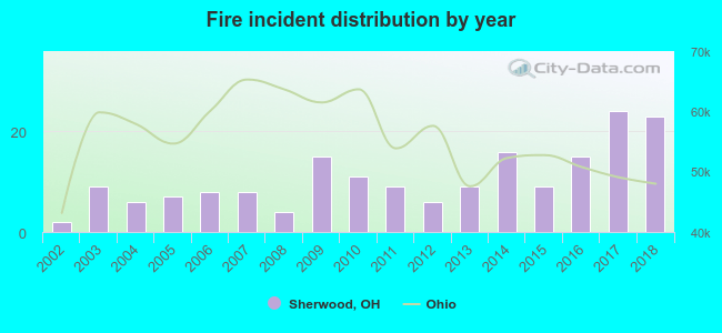
2002 - 2018 National Fire Incident Reporting System (NFIRS) incidents
According to the data from the years 2002 - 2018 the average number of fires per year is 11. The highest number of reported fires - 24 took place in 2017, and the least - 2 in 2002. The data has an increasing trend.
When looking into fire subcategories, the most reports belonged to: Structure Fires (61.9%), and Outside Fires (32.6%).
Fire incident types reported to NFIRS in Sherwood, OH


 Recent articles from our blog. Our writers, many of them Ph.D. graduates or candidates, create easy-to-read articles on a wide variety of topics.

 (8.1 miles


 According to the data from the years 2002 - 2018 the average number of fires per year is 11. The highest number of reported fires - 24 took place in 2017, and the least - 2 in 2002. The data has an increasing trend.
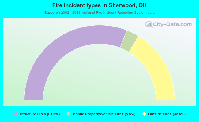 When looking into fire subcategories, the most reports belonged to: Structure Fires (61.9%), and Outside Fires (32.6%).