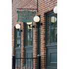
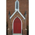
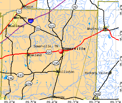
Somerville, Tennessee
Submit your own pictures of this town and show them to the world
- OSM Map
- General Map
- Google Map
- MSN Map
Population change since 2000: +35.2%
| Males: 1,501 | |
| Females: 1,905 |
| Median resident age: | 35.4 years |
| Tennessee median age: | 39.2 years |
Zip codes: 38068.
| Somerville: | $34,392 |
| TN: | $65,254 |
Estimated per capita income in 2022: $22,833 (it was $15,636 in 2000)
Somerville town income, earnings, and wages data
Estimated median house or condo value in 2022: $366,399 (it was $77,400 in 2000)
| Somerville: | $366,399 |
| TN: | $284,800 |
Mean prices in 2022: all housing units: $322,853; detached houses: $319,267
Median gross rent in 2022: $744.
(18.0% for White Non-Hispanic residents, 49.6% for Black residents, 100.0% for Hispanic or Latino residents, 73.1% for other race residents, 28.7% for two or more races residents)
Detailed information about poverty and poor residents in Somerville, TN

Compare current foreclosures in Somerville, TN:
| Photo | Address | Area | Beds / Baths | Price | Details |
|---|---|---|---|---|---|

|
#1
Hall Dr
Somerville, TN 38068
|
2,685 sq. feet
|
2 baths 3 beds |
$425,000
|
show details |

|
#2
Ebenezer Loop
Somerville, TN 38068
|
4,372 sq. feet
|
5 baths - beds |
show details | |

|
#3
Highway 76 S
Somerville, TN 38068
|
1,000 sq. feet
|
1 baths - beds |
show details | |

|
#4
Old Brownsville Rd
Somerville, TN 38068
|
1,040 sq. feet
|
1 baths - beds |
show details | |

|
#5
Jernigan Dr
Somerville, TN 38068
|
1,432 sq. feet
|
2 baths - beds |
show details | |

|
#6
Highway 195
Somerville, TN 38068
|
1,000 sq. feet
|
1 baths - beds |
show details | |

|
#7
Highway 193
Somerville, TN 38068
|
1,252 sq. feet
|
1 baths - beds |
show details | |

|
#8
Umbarger Dr
Somerville, TN 38068
|
756 sq. feet
|
1 baths - beds |
show details | |

|
#9
N West St
Somerville, TN 38068
|
1,276 sq. feet
|
1 baths - beds |
show details | |

|
#10
Rehoboth Rd
Somerville, TN 38068
|
816 sq. feet
|
5 baths - beds |
show details |
| Photo | Address | Area | Beds / Baths | Price | Details |
|---|---|---|---|---|---|

|
#11
Us Highway 64
Somerville, TN 38068
|
927 sq. feet
|
1 baths - beds |
show details | |

|
#12
Wagon Wheel Dr
Somerville, TN 38068
|
1,048 sq. feet
|
2 baths - beds |
show details | |

|
#13
Jernigan Dr
Somerville, TN 38068
|
933 sq. feet
|
1 baths - beds |
show details | |

|
#14
Bishop Dr
Somerville, TN 38068
|
1,440 sq. feet
|
2 baths - beds |
show details | |

|
#15
N Main St
Somerville, TN 38068
|
682 sq. feet
|
1 baths - beds |
show details | |

|
#16
Flippin St
Somerville, TN 38068
|
1,365 sq. feet
|
2 baths - beds |
show details | |

|
#17
Wagon Wheel Dr
Somerville, TN 38068
|
1,290 sq. feet
|
2 baths - beds |
show details | |

|
#18
Old Brownsville Rd
Somerville, TN 38068
|
988 sq. feet
|
1 baths - beds |
show details | |

|
#19
Highway 222
Somerville, TN 38068
|
1,198 sq. feet
|
1 baths - beds |
show details | |

|
#20
Lynnwood St
Somerville, TN 38068
|
1,336 sq. feet
|
2 baths - beds |
show details |
| Photo | Address | Area | Beds / Baths | Price | Details |
|---|---|---|---|---|---|

|
#21
Bailey Morrison Dr
Somerville, TN 38068
|
1,224 sq. feet
|
1 baths - beds |
show details | |

|
#22
Rogers Dr
Somerville, TN 38068
|
1,053 sq. feet
|
1 baths - beds |
show details | |

|
#23
Highway 76 N
Somerville, TN 38068
|
1,576 sq. feet
|
1 baths - beds |
show details | |

|
#24
Highway 195
Somerville, TN 38068
|
1,025 sq. feet
|
1 baths - beds |
show details | |

|
#25
Old Jackson Rd
Somerville, TN 38068
|
1,950 sq. feet
|
2 baths - beds |
show details | |

|
#26
Teague Store Rd
Somerville, TN 38068
|
1,075 sq. feet
|
1 baths - beds |
show details | |

|
#27
Neal Rd
Somerville, TN 38068
|
1,092 sq. feet
|
1 baths - beds |
show details | |

|
#28
N West St
Somerville, TN 38068
|
1,274 sq. feet
|
2 baths - beds |
show details | |

|
#29
Ware Rd
Somerville, TN 38068
|
1,301 sq. feet
|
2 baths - beds |
show details | |

|
#30
S Somerville St
Somerville, TN 38068
|
986 sq. feet
|
1 baths - beds |
show details |
| Photo | Address | Area | Beds / Baths | Price | Details |
|---|---|---|---|---|---|

|
#31
Stuart Loop
Somerville, TN 38068
|
1,075 sq. feet
|
1 baths - beds |
show details | |

|
#32
Finnie Dr
Somerville, TN 38068
|
2,360 sq. feet
|
2 baths - beds |
show details | |

|
#33
Fayette Corner Dr
Somerville, TN 38068
|
2,110 sq. feet
|
2 baths - beds |
show details | |

|
#34
Us Highway 64
Somerville, TN 38068
|
- sq. feet
|
- baths - beds |
show details | |

|
#35
Highway 195
Somerville, TN 38068
|
- sq. feet
|
- baths - beds |
show details | |

|
#36
Nicholas Dr
Somerville, TN 38068
|
- sq. feet
|
- baths - beds |
show details | |

|
#37
Old Jackson Rd
Somerville, TN 38068
|
- sq. feet
|
- baths - beds |
show details | |

|
#38
Armour Dr
Somerville, TN 38068
|
- sq. feet
|
- baths - beds |
show details | |

|
#39
Taylor Dr
Somerville, TN 38068
|
1,152 sq. feet
|
- baths - beds |
show details | |

|
#40
Clark Rd
Somerville, TN 38068
|
- sq. feet
|
- baths - beds |
show details |
| Photo | Address | Area | Beds / Baths | Price | Details |
|---|---|---|---|---|---|

|
#41
Armour Dr
Somerville, TN 38068
|
- sq. feet
|
- baths - beds |
show details | |

|
#42
S Somerville St
Somerville, TN 38068
|
- sq. feet
|
- baths - beds |
show details | |

|
#43
Morris Dr
Somerville, TN 38068
|
- sq. feet
|
- baths - beds |
show details | |

|
#44
Highway 195 # 9
Somerville, TN 38068
|
- sq. feet
|
- baths - beds |
show details | |

|
#45
Clark Rd
Somerville, TN 38068
|
- sq. feet
|
- baths - beds |
show details | |

|
Check over 1 million property listings on Foreclosure.com!
|
browse all offers | |||


- 1,68348.8%White alone
- 1,46742.6%Black alone
- 2166.3%Two or more races
- 300.9%Hispanic
- 110.3%American Indian alone
- 80.2%Other race alone
- 10.03%Asian alone
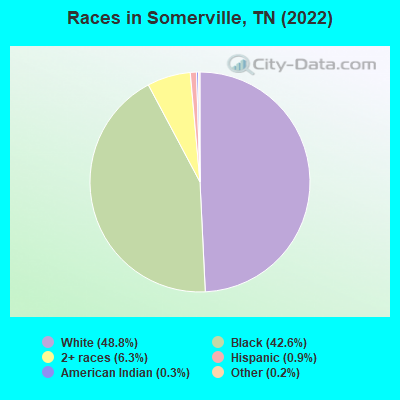
Races in Somerville detailed stats: ancestries, foreign born residents, place of birth
According to our research of Tennessee and other state lists, there were 28 registered sex offenders living in Somerville, Tennessee as of May 05, 2024.
The ratio of all residents to sex offenders in Somerville is 114 to 1.
Type |
2009 |
2010 |
2011 |
2013 |
2014 |
2015 |
2016 |
2017 |
2018 |
2019 |
2020 |
2021 |
2022 |
|---|---|---|---|---|---|---|---|---|---|---|---|---|---|
| Murders (per 100,000) | 0 (0.0) | 0 (0.0) | 0 (0.0) | 0 (0.0) | 0 (0.0) | 0 (0.0) | 0 (0.0) | 1 (31.9) | 0 (0.0) | 1 (31.1) | 0 (0.0) | 1 (30.7) | 0 (0.0) |
| Rapes (per 100,000) | 0 (0.0) | 2 (64.6) | 1 (32.0) | 1 (31.8) | 2 (64.1) | 2 (64.4) | 1 (32.3) | 1 (31.9) | 2 (62.2) | 1 (31.1) | 0 (0.0) | 1 (30.7) | 1 (28.8) |
| Robberies (per 100,000) | 3 (101.1) | 2 (64.6) | 1 (32.0) | 3 (95.5) | 3 (96.1) | 5 (160.9) | 2 (64.6) | 3 (95.6) | 2 (62.2) | 1 (31.1) | 2 (60.9) | 0 (0.0) | 1 (28.8) |
| Assaults (per 100,000) | 32 (1,079) | 52 (1,681) | 36 (1,153) | 12 (381.9) | 8 (256.3) | 11 (354.0) | 21 (678.5) | 14 (446.0) | 20 (622.5) | 12 (373.5) | 27 (822.7) | 34 (1,042) | 20 (576.4) |
| Burglaries (per 100,000) | 22 (741.7) | 25 (808.0) | 16 (512.5) | 11 (350.1) | 16 (512.7) | 36 (1,159) | 27 (872.4) | 19 (605.3) | 6 (186.7) | 7 (217.9) | 8 (243.8) | 17 (521.2) | 10 (288.2) |
| Thefts (per 100,000) | 91 (3,068) | 113 (3,652) | 41 (1,313) | 73 (2,323) | 93 (2,980) | 78 (2,510) | 83 (2,682) | 62 (1,975) | 41 (1,276) | 40 (1,245) | 42 (1,280) | 42 (1,288) | 32 (922.2) |
| Auto thefts (per 100,000) | 3 (101.1) | 4 (129.3) | 2 (64.1) | 2 (63.7) | 3 (96.1) | 8 (257.5) | 6 (193.9) | 5 (159.3) | 8 (249.0) | 6 (186.7) | 4 (121.9) | 1 (30.7) | 4 (115.3) |
| Arson (per 100,000) | 0 (0.0) | 0 (0.0) | 0 (0.0) | 1 (31.8) | 1 (32.0) | 0 (0.0) | 0 (0.0) | 0 (0.0) | 0 (0.0) | 2 (62.2) | 0 (0.0) | 0 (0.0) | 0 (0.0) |
| City-Data.com crime index | 428.9 | 620.2 | 359.4 | 253.0 | 294.1 | 372.7 | 364.8 | 341.2 | 277.0 | 251.2 | 260.8 | 384.7 | 213.3 |
The City-Data.com crime index weighs serious crimes and violent crimes more heavily. Higher means more crime, U.S. average is 246.1. It adjusts for the number of visitors and daily workers commuting into cities.
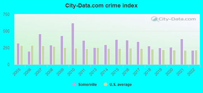
Crime rate in Somerville detailed stats: murders, rapes, robberies, assaults, burglaries, thefts, arson
Full-time law enforcement employees in 2021, including police officers: 12 (11 officers - 11 male; 0 female).
| Officers per 1,000 residents here: | 3.37 |
| Tennessee average: | 2.57 |
 Recent articles from our blog. Our writers, many of them Ph.D. graduates or candidates, create easy-to-read articles on a wide variety of topics.

 | Higher End... some property (91 replies) |
| Johnson City (22 replies) |
| Stops from Memphis to Nashville? (14 replies) |
| Wanting out of the Boston area. (8 replies) |
| Rural towns within an hour drive of Memphis? (6 replies) |
| Looking to relocate in Oakland.. where is the high school located? (7 replies) |
Latest news from Somerville, TN collected exclusively by city-data.com from local newspapers, TV, and radio stations
Somerville, TN City Guides:
Ancestries: American (20.5%), English (7.7%), Irish (7.1%), Scottish (4.0%), Scotch-Irish (2.5%), German (1.4%).
Current Local Time: CST time zone
Incorporated in 1854
Elevation: 408 feet
Land area: 11.2 square miles.
Population density: 305 people per square mile (very low).
| Somerville town: | 0.5% ($367) |
| Tennessee: | 0.8% ($715) |
Nearest city with pop. 50,000+: Memphis, TN  (35.6 miles , pop. 650,100).
Nearest city with pop. 1,000,000+: Dallas, TX (457.9 miles , pop. 1,188,580).
Nearest cities:
), ), ), ), ), ), Latitude: 35.24 N, Longitude: 89.36 W
Area code: 901
Somerville, Tennessee accommodation & food services, waste management - Economy and Business Data
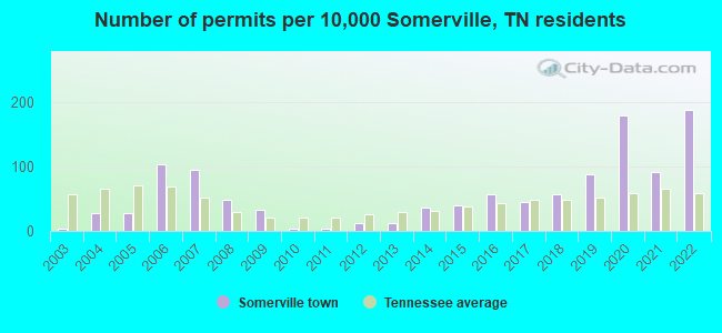
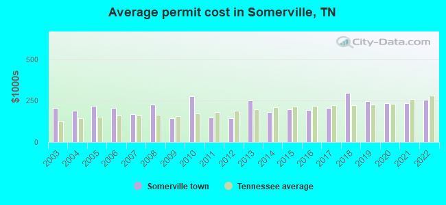
Single-family new house construction building permits:
- 2022: 47 buildings, average cost: $255,900
- 2021: 23 buildings, average cost: $236,900
- 2020: 45 buildings, average cost: $233,500
- 2019: 22 buildings, average cost: $248,100
- 2018: 14 buildings, average cost: $297,300
- 2017: 11 buildings, average cost: $207,300
- 2016: 14 buildings, average cost: $195,000
- 2015: 10 buildings, average cost: $198,200
- 2014: 9 buildings, average cost: $181,700
- 2013: 3 buildings, average cost: $250,000
- 2012: 3 buildings, average cost: $145,000
- 2011: 1 building, cost: $150,000
- 2010: 1 building, cost: $275,000
- 2009: 8 buildings, average cost: $143,100
- 2008: 12 buildings, average cost: $224,600
- 2007: 24 buildings, average cost: $170,500
- 2006: 26 buildings, average cost: $208,400
- 2005: 7 buildings, average cost: $220,400
- 2004: 7 buildings, average cost: $187,600
- 2003: 1 building, cost: $208,400
| Here: | 3.8% |
| Tennessee: | 3.0% |
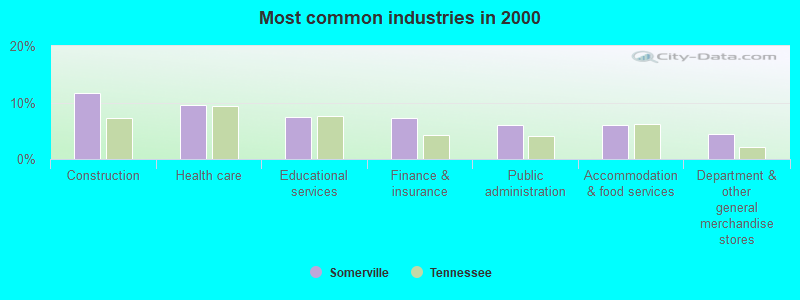
- Construction (11.8%)
- Health care (9.6%)
- Educational services (7.4%)
- Finance & insurance (7.2%)
- Public administration (6.0%)
- Accommodation & food services (6.0%)
- Department & other general merchandise stores (4.4%)
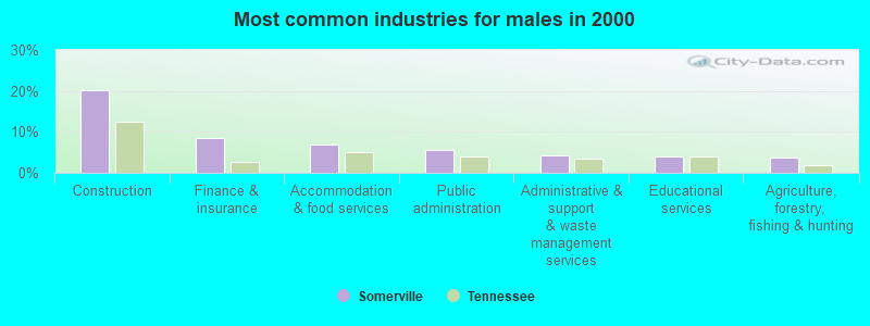
- Construction (20.1%)
- Finance & insurance (8.4%)
- Accommodation & food services (6.9%)
- Public administration (5.5%)
- Administrative & support & waste management services (4.3%)
- Educational services (4.1%)
- Agriculture, forestry, fishing & hunting (3.8%)
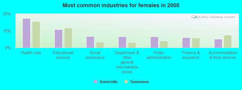
- Health care (17.3%)
- Educational services (10.8%)
- Social assistance (6.7%)
- Department & other general merchandise stores (6.5%)
- Public administration (6.5%)
- Finance & insurance (6.0%)
- Accommodation & food services (5.1%)
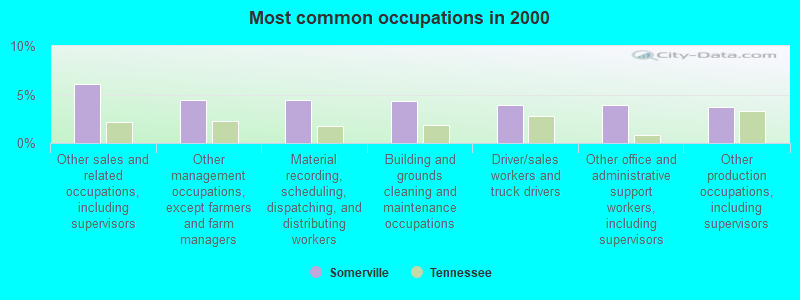
- Other sales and related occupations, including supervisors (6.1%)
- Other management occupations, except farmers and farm managers (4.4%)
- Material recording, scheduling, dispatching, and distributing workers (4.4%)
- Building and grounds cleaning and maintenance occupations (4.3%)
- Driver/sales workers and truck drivers (4.0%)
- Other office and administrative support workers, including supervisors (4.0%)
- Other production occupations, including supervisors (3.7%)
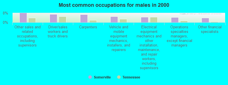
- Other sales and related occupations, including supervisors (7.9%)
- Driver/sales workers and truck drivers (6.9%)
- Carpenters (6.7%)
- Vehicle and mobile equipment mechanics, installers, and repairers (5.0%)
- Electrical equipment mechanics and other installation, maintenance, and repair workers, including supervisors (4.5%)
- Operations specialties managers, except financial managers (4.3%)
- Other financial specialists (3.8%)
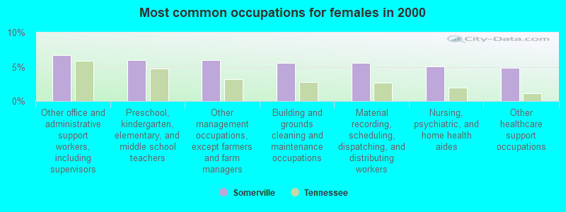
- Other office and administrative support workers, including supervisors (6.7%)
- Preschool, kindergarten, elementary, and middle school teachers (6.0%)
- Other management occupations, except farmers and farm managers (6.0%)
- Building and grounds cleaning and maintenance occupations (5.5%)
- Material recording, scheduling, dispatching, and distributing workers (5.5%)
- Nursing, psychiatric, and home health aides (5.1%)
- Other healthcare support occupations (4.8%)
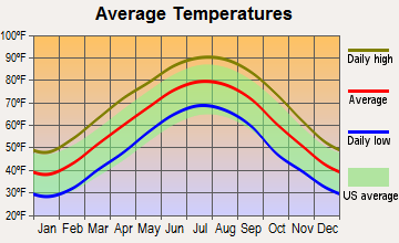
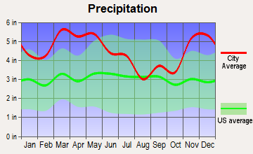
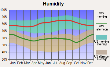
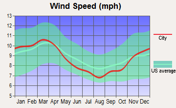
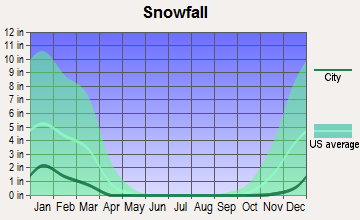
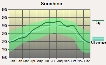
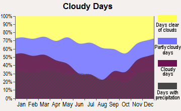
Average climate in Somerville, Tennessee
Based on data reported by over 4,000 weather stations
|
|


(lower is better)
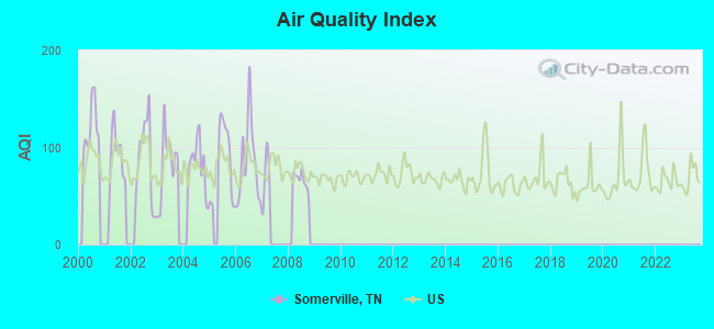
Air Quality Index (AQI) level in 2008 was 66.5. This is about average.
| City: | 66.5 |
| U.S.: | 72.6 |
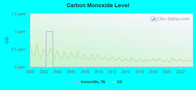
Carbon Monoxide (CO) [ppm] level in 2002 was 1.00. This is significantly worse than average. Closest monitor was 19.2 miles away from the city center.
| City: | 1.00 |
| U.S.: | 0.25 |
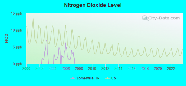
Nitrogen Dioxide (NO2) [ppb] level in 2006 was 2.59. This is significantly better than average. Closest monitor was 16.4 miles away from the city center.
| City: | 2.59 |
| U.S.: | 5.11 |
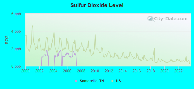
Sulfur Dioxide (SO2) [ppb] level in 2006 was 1.28. This is about average. Closest monitor was 16.4 miles away from the city center.
| City: | 1.28 |
| U.S.: | 1.51 |
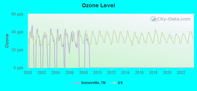
Ozone [ppb] level in 2008 was 31.4. This is about average. Closest monitor was 16.4 miles away from the city center.
| City: | 31.4 |
| U.S.: | 33.3 |
Tornado activity:
Somerville-area historical tornado activity is slightly above Tennessee state average. It is 97% greater than the overall U.S. average.
On 3/21/1952, a category F4 (max. wind speeds 207-260 mph) tornado 9.3 miles away from the Somerville town center killed 16 people and injured 74 people and caused between $50,000 and $500,000 in damages.
On 3/21/1952, a category F4 tornado 21.5 miles away from the town center killed 38 people and injured 157 people and caused between $500,000 and $5,000,000 in damages.
Earthquake activity:
Somerville-area historical earthquake activity is significantly above Tennessee state average. It is 345% greater than the overall U.S. average.On 3/25/1976 at 00:41:20, a magnitude 5.0 (4.9 MB, 5.0 LG, Class: Moderate, Intensity: VI - VII) earthquake occurred 61.2 miles away from the city center
On 5/4/1991 at 01:18:54, a magnitude 5.0 (4.4 MB, 4.6 LG, 5.0 LG, Depth: 3.1 mi) earthquake occurred 95.4 miles away from Somerville center
On 4/27/1989 at 16:47:49, a magnitude 4.7 (4.6 MB, 4.7 LG, 4.3 LG, Class: Light, Intensity: IV - V) earthquake occurred 57.9 miles away from the city center
On 9/26/1990 at 13:18:51, a magnitude 5.0 (4.7 MB, 4.8 LG, 5.0 LG, Depth: 7.7 mi) earthquake occurred 133.8 miles away from the city center
On 4/18/2008 at 09:36:59, a magnitude 5.4 (5.1 MB, 4.8 MS, 5.4 MW, 5.2 MW) earthquake occurred 236.8 miles away from the city center
On 3/25/1976 at 01:00:11, a magnitude 4.5 (4.1 MB, 4.5 LG) earthquake occurred 68.3 miles away from the city center
Magnitude types: regional Lg-wave magnitude (LG), body-wave magnitude (MB), surface-wave magnitude (MS), moment magnitude (MW)
Natural disasters:
The number of natural disasters in Fayette County (13) is near the US average (15).Major Disasters (Presidential) Declared: 10
Emergencies Declared: 1
Causes of natural disasters: Storms: 9, Tornadoes: 7, Winds: 7, Floods: 6, Winter Storms: 2, Flash Flood: 1, Heavy Rain: 1, Hurricane: 1, Ice Storm: 1, Other: 1 (Note: some incidents may be assigned to more than one category).
Hospitals and medical centers in Somerville:
Airports and heliports located in Somerville:
- Fayette County Airport (FYE) (Runways: 1, Air Taxi Ops: 72, Itinerant Ops: 2,920, Local Ops: 7,000, Military Ops: 24)
- Methodist Hospital Heliport (TN27)
Colleges/universities with over 2000 students nearest to Somerville:
- Rhodes College (about 37 miles; Memphis, TN; Full-time enrollment: 2,052)
- University of Memphis (about 37 miles; Memphis, TN; FT enrollment: 17,427)
- Southwest Tennessee Community College (about 39 miles; Memphis, TN; FT enrollment: 8,043)
- Union University (about 42 miles; Jackson, TN; FT enrollment: 4,051)
- Jackson State Community College (about 44 miles; Jackson, TN; FT enrollment: 2,958)
- Northwest Mississippi Community College (about 55 miles; Senatobia, MS; FT enrollment: 6,607)
- Dyersburg State Community College (about 57 miles; Dyersburg, TN; FT enrollment: 2,211)
Public high school in Somerville:
- FAYETTE WARE COMPREHENSIVE HIGH SCHOOL (Students: 696, Location: 13520 HWY 59 WEST, Grades: 9-12)
Private high schools in Somerville:
Public elementary/middle schools in Somerville:
- EAST JR. HIGH SCHOOL (Students: 479, Location: 400 LEACH RD, Grades: 6-8)
- JEFFERSON ELEMENTARY (Students: 205, Location: 13955 HIGHWAY 59, WEST, Grades: PK-5)
- CENTRAL ELEMENTARY (Location: 10425 HIGHWAY 76, SOUTH, Grades: PK-5)
- BUCKLEY-CARPENTER ELEMENTARY SCHOOL (Location: 12580 S MAIN ST, Grades: PK-5)
User-submitted facts and corrections:
- We are a school in Fayette County, La Grange, TN. We would like to be added to the Private School listing. Our contact information is: 21450 Highway 57 P.O. Box 365 La Grange, TN 38046 901.878.1499 www.TheLaGrangeSchool.org How do we go about getting our school added? Thank you in advance for your assistance!
Points of interest:
Notable locations in Somerville: Fayette County Landfill (A), Somerville Fire Department (B), Fayette County Fire Department District 15 Station 2 (C), Fayette County Courthouse (D), Fayette County Ambulance Service (E). Display/hide their locations on the map
Churches in Somerville include: Spring Hill Church (A), Somerville First Baptist Church (B). Display/hide their locations on the map
Cemeteries: Spring Hill Cemetery (1), Somerville Cemetery (2), Stitts Cemetery (3). Display/hide their locations on the map
Reservoir: Glengary Lake (A). Display/hide its location on the map
Hotel: Deerfield Inn (17307 US Highway 64) (1). Display/hide its approximate location on the map
Courts: Fayette County - Juvenile Court (1 Court Square) (1), Fayette County - County Court Clerk (1 Court Square) (2), Fayette County - Circuit Court Clerk (1 Court Square) (3). Display/hide their approximate locations on the map
Birthplace of: Homesick James - Blues musician, Ingram Stainback - Politician, Carlos Clark - Basketball player, Frank Holmes - College basketball player (UAB Blazers), William L. Wainwright - North Carolina politician.
Drinking water stations with addresses in Somerville and their reported violations in the past:
SOUTHWEST SCHOOL (Population served: 412, Groundwater):Past health violations:
- MCL, Monthly (TCR) - Between APR-2007 and JUN-2007, Contaminant: Coliform. Follow-up actions: St Public Notif received (MAY-11-2007), St Public Notif requested (JUL-31-2007), St Violation/Reminder Notice (JUL-31-2007), St Compliance achieved (SEP-30-2007)
Drinking water stations with addresses in Somerville that have no violations reported:
- SOMERVILLE WATER SYSTEM (Population served: 4,800, Primary Water Source Type: Groundwater)
| This town: | 2.3 people |
| Tennessee: | 2.5 people |
| This town: | 61.1% |
| Whole state: | 67.3% |
| This town: | 5.7% |
| Whole state: | 5.8% |
Likely homosexual households (counted as self-reported same-sex unmarried-partner households)
- Lesbian couples: 0.5% of all households
- Gay men: 0.4% of all households
People in group quarters in Somerville in 2010:
- 103 people in local jails and other municipal confinement facilities
- 71 people in nursing facilities/skilled-nursing facilities
- 17 people in emergency and transitional shelters (with sleeping facilities) for people experiencing homelessness
- 6 people in group homes intended for adults
- 3 people in other noninstitutional facilities
People in group quarters in Somerville in 2000:
- 94 people in local jails and other confinement facilities (including police lockups)
- 75 people in nursing homes
- 7 people in homes for the mentally ill
Banks with branches in Somerville (2011 data):
- The Somerville Bank & Trust Company: Somerville Branch at Highway 64 West, branch established on 1984/10/21; at 16790 Hwy 64, branch established on 1910/01/01. Info updated 2006/11/03: Bank assets: $197.9 mil, Deposits: $174.9 mil, local headquarters, positive income, 5 total offices, Holding Company: Trustmark Corporation
- The Farmers Bank of Lynchburg: Somerville Branch at 16814 Highway 64, branch established on 2001/03/27. Info updated 2010/06/01: Bank assets: $158.8 mil, Deposits: $150.5 mil, headquarters in Lynchburg, TN, negative income in the last year, Commercial Lending Specialization, 5 total offices, Holding Company: Farmers Bancorp, Inc.
- The Bank of Fayette County: Somerville Branch at 15995 Highway 64, branch established on 2002/04/01. Info updated 2006/11/03: Bank assets: $307.8 mil, Deposits: $253.8 mil, headquarters in Moscow, TN, positive income, Commercial Lending Specialization, 9 total offices, Holding Company: Moscow Bancshares, Inc.
- Regions Bank: Somerville Branch at 16880 Highway 64, branch established on 1965/03/15. Info updated 2011/02/24: Bank assets: $123,368.2 mil, Deposits: $98,301.3 mil, headquarters in Birmingham, AL, positive income, Commercial Lending Specialization, 1778 total offices, Holding Company: Regions Financial Corporation
- BancorpSouth Bank: Somerville Branch at 430 W Fayette, branch established on 1934/10/01. Info updated 2007/07/18: Bank assets: $12,990.3 mil, Deposits: $10,863.8 mil, headquarters in Tupelo, MS, positive income, Commercial Lending Specialization, 271 total offices, Holding Company: Bancorpsouth, Inc.
For population 15 years and over in Somerville:
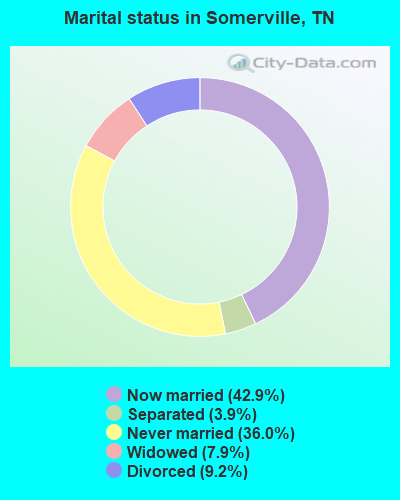
- Never married: 36.0%
- Now married: 42.9%
- Separated: 3.9%
- Widowed: 7.9%
- Divorced: 9.2%
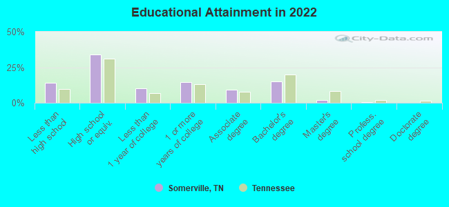
For population 25 years and over in Somerville:
- High school or higher: 83.8%
- Bachelor's degree or higher: 16.5%
- Graduate or professional degree: 2.4%
- Unemployed: 10.8%
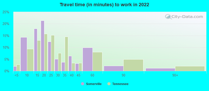
- Mean travel time to work (commute): 28.0 minutes
| Here: | 9.5 |
| Tennessee average: | 11.4 |
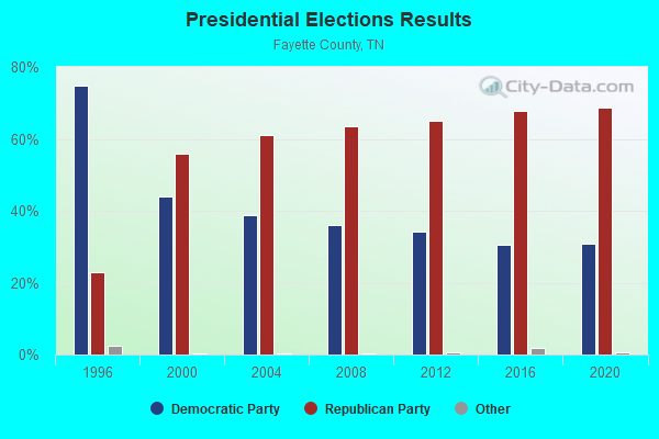
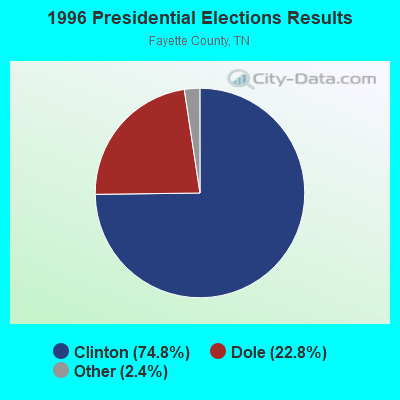
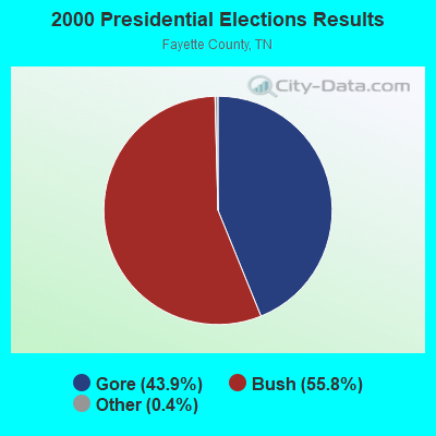
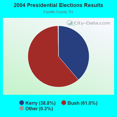
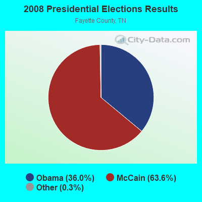
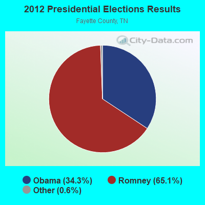


Graphs represent county-level data. Detailed 2008 Election Results
Religion statistics for Somerville, TN (based on Fayette County data)
| Religion | Adherents | Congregations |
|---|---|---|
| Evangelical Protestant | 8,093 | 40 |
| Black Protestant | 2,221 | 17 |
| Mainline Protestant | 1,882 | 20 |
| Catholic | 900 | 1 |
| Other | 458 | 2 |
| None | 24,859 | - |
Food Environment Statistics:
| Fayette County: | 1.08 / 10,000 pop. |
| Tennessee: | 1.99 / 10,000 pop. |
| Fayette County: | 0.81 / 10,000 pop. |
| Tennessee: | 0.65 / 10,000 pop. |
| Here: | 4.31 / 10,000 pop. |
| Tennessee: | 5.16 / 10,000 pop. |
| Fayette County: | 5.12 / 10,000 pop. |
| Tennessee: | 6.56 / 10,000 pop. |
| This county: | 11.1% |
| Tennessee: | 11.4% |
| This county: | 33.8% |
| State: | 30.2% |
| Fayette County: | 12.5% |
| State: | 13.5% |
Health and Nutrition:
| Somerville: | 47.7% |
| Tennessee: | 49.3% |
| Somerville: | 42.4% |
| Tennessee: | 46.1% |
| Somerville: | 29.4 |
| Tennessee: | 28.8 |
| Somerville: | 23.1% |
| State: | 21.0% |
| Somerville: | 13.9% |
| Tennessee: | 10.5% |
| Somerville: | 6.8 |
| Tennessee: | 6.8 |
| Here: | 34.5% |
| Tennessee: | 33.9% |
| This city: | 51.6% |
| Tennessee: | 55.9% |
| This city: | 76.9% |
| Tennessee: | 79.1% |
More about Health and Nutrition of Somerville, TN Residents
| Local government employment and payroll (March 2022) | |||||
| Function | Full-time employees | Monthly full-time payroll | Average yearly full-time wage | Part-time employees | Monthly part-time payroll |
|---|---|---|---|---|---|
| Gas Supply | 11 | $39,686 | $43,294 | 0 | $0 |
| Financial Administration | 11 | $50,315 | $54,889 | 0 | $0 |
| Police Protection - Officers | 10 | $45,901 | $55,081 | 1 | $928 |
| Firefighters | 4 | $17,679 | $53,037 | 1 | $122 |
| Water Supply | 4 | $17,422 | $52,266 | 0 | $0 |
| Solid Waste Management | 3 | $7,830 | $31,320 | 0 | $0 |
| Sewerage | 3 | $11,841 | $47,364 | 0 | $0 |
| Streets and Highways | 3 | $10,793 | $43,172 | 0 | $0 |
| Other Government Administration | 0 | $0 | 12 | $3,150 | |
| Totals for Government | 49 | $201,466 | $49,339 | 14 | $4,200 |
Somerville government finances - Expenditure in 2017 (per resident):
- Current Operations - Gas Utilities: $3,401,000 ($998.53)
- General - Interest on Debt: $158,000 ($46.39)
- Total Salaries and Wages: $1,804,000 ($529.65)
Somerville government finances - Revenue in 2017 (per resident):
- Charges - Sewerage: $738,000 ($216.68)
- Revenue - Gas Utilities: $3,236,000 ($950.09)
Water Utilities: $670,000 ($196.71)
- State Intergovernmental - Sewerage: $164,000 ($48.15)
Highways: $86,000 ($25.25)
- Tax - General Sales and Gross Receipts: $518,000 ($152.08)
Property: $480,000 ($140.93)
Alcoholic Beverage Sales: $1,000 ($0.29)
Somerville government finances - Debt in 2017 (per resident):
- Long Term Debt - Beginning Outstanding - Unspecified Public Purpose: $3,948,000 ($1159.13)
Outstanding Unspecified Public Purpose: $3,795,000 ($1114.21)
Retired Unspecified Public Purpose: $152,000 ($44.63)
Somerville government finances - Cash and Securities in 2017 (per resident):
- Other Funds - Cash and Securities: $9,964,000 ($2925.43)
| Businesses in Somerville, TN | ||||
| Name | Count | Name | Count | |
|---|---|---|---|---|
| AT&T | 1 | Lane Furniture | 1 | |
| AutoZone | 1 | RadioShack | 1 | |
| Baskin-Robbins | 1 | SONIC Drive-In | 1 | |
| FedEx | 1 | Subway | 1 | |
| H&R Block | 1 | U-Haul | 1 | |
Strongest AM radio stations in Somerville:
- WSTN (1410 AM; 0 kW; SOMERVILLE, TN; Owner: FAMILY WORSHIP CENTER CHURCH, INC.)
- WCRV (640 AM; 50 kW; COLLIERVILLE, TN; Owner: BOTT BROADCASTING COMPANY/TENNESSEE)
- WMQM (1600 AM; 50 kW; LAKELAND, TN; Owner: WMQM, INC.)
- WGSF (1030 AM; 50 kW; MEMPHIS, TN; Owner: FLINN BROADCASTING CORPORATION)
- WDIA (1070 AM; 50 kW; MEMPHIS, TN; Owner: CLEAR CHANNEL BROADCASTING LICENSES, INC.)
- WPLX (1170 AM; 10 kW; GERMANTOWN, TN; Owner: EDUCATIONAL MEDIA FOUNDATION)
- WJCE (680 AM; 10 kW; MEMPHIS, TN; Owner: ENTERCOM MEMPHIS LICENSE, LLC)
- KWAM (990 AM; 10 kW; MEMPHIS, TN; Owner: CONCORD MEDIA GROUP, INC.)
- WMC (790 AM; 5 kW; MEMPHIS, TN; Owner: INFINITY RADIO OPERATIONS INC.)
- WCPC (940 AM; 50 kW; HOUSTON, MS; Owner: WCPC BROADCASTING CO., INC.)
- WREC (600 AM; 5 kW; MEMPHIS, TN; Owner: CLEAR CHANNEL BROADCASTING LICENSES, INC.)
- WHBQ (560 AM; 5 kW; MEMPHIS, TN; Owner: FLINN BROADCASTING CORPORATION)
- WSM (650 AM; 50 kW; NASHVILLE, TN; Owner: GAYLORD ENTERTAINMENT COMPANY)
Strongest FM radio stations in Somerville:
- WSRR-FM (98.1 FM; MILLINGTON, TN; Owner: KOOL BROADCASTING, INC.)
- WEGR (102.7 FM; MEMPHIS, TN; Owner: CLEAR CHANNEL BROADCASTING LICENSES, INC.)
- WGKX (105.9 FM; MEMPHIS, TN; Owner: KIX BROADCASTING, INC.)
- WRVR-FM (104.5 FM; MEMPHIS, TN; Owner: ENTERCOM MEMPHIS LICENSE, LLC)
- WMC-FM (99.7 FM; MEMPHIS, TN; Owner: INFINITY RADIO OPERATIONS INC.)
- WKNO-FM (91.1 FM; MEMPHIS, TN; Owner: MID-SOUTH PUBLIC COMMUNICATIONS FOUNDATION)
- WYPL (89.3 FM; MEMPHIS, TN; Owner: MEMPHIS/SHELBY COUNTY PUBLIC LIBRARY & INFO CNTR.)
- WMPS (107.5 FM; GERMANTOWN, TN; Owner: FLINN BROADCASTING CORPORATION)
- WQOX (88.5 FM; MEMPHIS, TN; Owner: MEMPHIS CITY SCHOOLS)
- WEVL (89.9 FM; MEMPHIS, TN; Owner: SOUTHERN COMMUNICATION VOLUNTEERS, INC.)
- WKVF (94.9 FM; BYHALIA, MS; Owner: EDUCATIONAL MEDIA FOUNDATION)
- WOJG (94.7 FM; BOLIVAR, TN; Owner: JOHNNY W. SHAW & OPAL J. SHAW)
TV broadcast stations around Somerville:
- WMC-TV (Channel 5; MEMPHIS, TN; Owner: RAYCOM AMERICA, INC.)
- WLMT (Channel 30; MEMPHIS, TN; Owner: CLEAR CHANNEL BROADCASTING LICENSES, INC.)
- WPTY-TV (Channel 24; MEMPHIS, TN; Owner: CLEAR CHANNEL BROADCASTING LICENSES, INC.)
- WREG-TV (Channel 3; MEMPHIS, TN; Owner: NEW YORK TIMES MANAGEMENT SERVICES)
- WPXX-TV (Channel 50; MEMPHIS, TN; Owner: FLINN BROADCASTING CORPORATION)
- WKNO (Channel 10; MEMPHIS, TN; Owner: MID-SOUTH PUBLIC COMMUNICATIONS FOUNDATION)
- WHBQ-TV (Channel 13; MEMPHIS, TN; Owner: FOX TELEVISION STATIONS, INC.)
- W57CG (Channel 57; MEMPHIS, TN; Owner: GEORGE S. FLINN, JR.)
- WBUY (Channel 40; HOLLY SPRINGS, MS; Owner: TRINITY BROADCASTING NETWORK)
- WJKT (Channel 16; JACKSON, TN; Owner: CLEAR CHANNEL BROADCASTING LICENSES, INC.)
- W25BY (Channel 25; JACKSON, TN; Owner: MS COMMUNICATIONS, LLC)
- W38BY (Channel 38; JACKSON, TN; Owner: MS COMMUNICATIONS, LLC)
- W54BU (Channel 54; JACKSON, TN; Owner: MS COMMUNICATIONS, LLC)
- National Bridge Inventory (NBI) Statistics
- 41Number of bridges
- 407ft / 124mTotal length
- $14,069,000Total costs
- 187,531Total average daily traffic
- 17,220Total average daily truck traffic
- 328,998Total future (year 2040) average daily traffic
- New bridges - historical statistics
- 11940-1949
- 21950-1959
- 41960-1969
- 41970-1979
- 21980-1989
- 211990-1999
- 62000-2009
- 12010-2019
FCC Registered Cell Phone Towers:
1 (See the full list of FCC Registered Cell Phone Towers in Somerville)FCC Registered Antenna Towers:
75 (See the full list of FCC Registered Antenna Towers)FCC Registered Private Land Mobile Towers:
4 (See the full list of FCC Registered Private Land Mobile Towers in Somerville, TN)FCC Registered Broadcast Land Mobile Towers:
7 (See the full list of FCC Registered Broadcast Land Mobile Towers)FCC Registered Microwave Towers:
1- SOMERVILLE, .8 Mi S Se Int Of Rts 195 & 76 (Lat: 35.210361 Lon: -89.340889), Overall height: 127.4 m, Call Sign: WMT411,
Assigned Frequencies: 6286.19 MHz, 6197.24 MHz, 6004.50 MHz, 6034.15 MHz, Grant Date: 01/25/2011, Expiration Date: 02/01/2021, Cancellation Date: 09/04/2019, Certifier: Gregory M Romano, Registrant: Verizon Wireless, 5055 North Point Pkwy, Np2ne Network Engineering, Alpharetta, GA 30022, Phone: (770) 797-1070, Email:
FCC Registered Paging Towers:
1- Old Jackson Road (Lat: 35.267028 Lon: -89.315889), Call Sign: KNKP416,
Assigned Frequencies: 152.750 MHz, Grant Date: 05/11/1999, Expiration Date: 04/01/2009, Cancellation Date: 03/09/2005, Registrant: Keller & Heckman, 1001 G Street, Nw, Suite 500 W, Washington, DC 20001, Phone: (202) 434-4100
FCC Registered Maritime Coast & Aviation Ground Towers:
5- Fayette County Airport (Lat: 35.206194 Lon: -89.392778), Type: Tower, Call Sign: WNL5,
Assigned Frequencies: 119.875 MHz, Grant Date: 08/31/2016, Expiration Date: 10/24/2026, Registrant: State Of Tennessee Department Of Transportation Aeronautics Division, 607 Hangar Lane Building 4219, Nashville, TN 37217, Phone: (615) 741-3208, Fax: (615) 741-4959, Email:
- Fayette County Airport (Lat: 35.205361 Lon: -89.392583), Type: Tower, Call Sign: WRLB3336,
Assigned Frequencies: 0.25500 MHz, Grant Date: 01/24/1994, Expiration Date: 01/24/1999, Cancellation Date: 05/06/2001, Registrant: County Of Fayette, Room 204 Courthouse, Somerville, TN 38068
- 1075 Airport Rd (Lat: 35.207056 Lon: -89.393083), Type: Building, Structure height: 3 m, Call Sign: WRNX517,
Assigned Frequencies: 120.400 MHz, Grant Date: 09/07/2021, Expiration Date: 09/26/2021, Cancellation Date: 11/27/2021, Certifier: Russell E Bliss, Registrant: Lexthistle Enterprises LLC, 172 Fire Willow Trl, Sunset, LA 70584, Phone: (337) 290-0807, Email:
- 1075 Airport Rd (Lat: 35.207056 Lon: -89.393083), Type: Building, Structure height: 2 m, Call Sign: WRUQ441,
Assigned Frequencies: 120.400 MHz, Grant Date: 09/21/2022, Expiration Date: 10/02/2022, Cancellation Date: 12/03/2022, Certifier: Russell E Bliss, Registrant: Lexthistle Enterprises LLC, 172 Fire Willow Trl, Sunset, LA 70584, Phone: (337) 290-0807, Email:
- 1075 Airport Rd (Lat: 35.207056 Lon: -89.393083), Type: Building, Structure height: 2 m, Call Sign: WRYN628,
Assigned Frequencies: 120.400 MHz, Grant Date: 08/30/2023, Expiration Date: 10/01/2023, Cancellation Date: 12/02/2023, Certifier: Russell E Bliss, Registrant: Lexthistle Enterprises LLC, 172 Fire Willow Trl, Sunset, LA 70584, Phone: (337) 290-0807, Email:
FCC Registered Amateur Radio Licenses:
32 (See the full list of FCC Registered Amateur Radio Licenses in Somerville)FAA Registered Aircraft Manufacturers and Dealers:
1 (See the full list of FAA Registered Manufacturers and Dealers in Somerville)FAA Registered Aircraft:
14 (See the full list of FAA Registered Aircraft)2002 - 2018 National Fire Incident Reporting System (NFIRS) incidents
- Fire incident types reported to NFIRS in Somerville, TN
- 70445.9%Structure Fires
- 61840.3%Outside Fires
- 20013.0%Mobile Property/Vehicle Fires
- 120.8%Other
 Based on the data from the years 2002 - 2018 the average number of fire incidents per year is 90. The highest number of fire incidents - 195 took place in 2007, and the least - 2 in 2003. The data has an increasing trend.
 When looking into fire subcategories, the most incidents belonged to: Structure Fires (45.9%), and Outside Fires (40.3%).
| Most common first names in Somerville, TN among deceased individuals | ||
| Name | Count | Lived (average) |
|---|---|---|
| James | 110 | 70.4 years |
| Mary | 102 | 79.3 years |
| John | 90 | 75.2 years |
| William | 87 | 75.5 years |
| Robert | 65 | 71.5 years |
| Willie | 58 | 75.1 years |
| George | 55 | 73.3 years |
| Charlie | 32 | 76.8 years |
| Joe | 29 | 74.8 years |
| Charles | 29 | 69.2 years |
| Most common last names in Somerville, TN among deceased individuals | ||
| Last name | Count | Lived (average) |
|---|---|---|
| Jones | 64 | 74.7 years |
| Taylor | 48 | 75.6 years |
| Davis | 39 | 71.0 years |
| Williams | 36 | 69.6 years |
| Johnson | 34 | 69.1 years |
| Williamson | 33 | 78.9 years |
| Smith | 32 | 73.9 years |
| Morris | 28 | 78.7 years |
| Brown | 27 | 76.0 years |
| Parks | 20 | 77.1 years |
- 73.4%Utility gas
- 25.4%Electricity
- 1.1%Bottled, tank, or LP gas
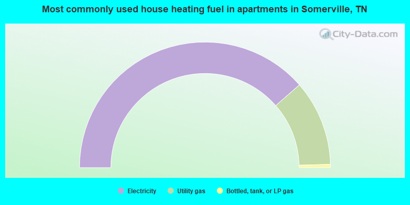
- 77.1%Electricity
- 22.1%Utility gas
- 0.8%Bottled, tank, or LP gas
Somerville compared to Tennessee state average:
- Median household income below state average.
- Black race population percentage significantly above state average.
- Hispanic race population percentage significantly below state average.
- Foreign-born population percentage significantly below state average.
- Renting percentage above state average.
- Length of stay since moving in significantly below state average.
- Institutionalized population percentage significantly above state average.
Somerville on our top lists:
- #47 on the list of "Top 101 cities with the largest percentage of people in dormitories (population 1,000+)"
- #47 on the list of "Top 101 cities with the largest percentage of people in group homes (population 1,000+)"
- #47 on the list of "Top 101 cities with the largest percentage of people in hospitals/wards, hospices, and schools for the handicapped (population 1,000+)"
- #47 on the list of "Top 101 cities with the largest percentage of people in long-term care (population 1,000+)"
- #47 on the list of "Top 101 cities with the largest percentage of people in military quarters (population 1,000+)"
- #47 on the list of "Top 101 cities with the largest percentage of people in noninstitutionalized settings (population 1,000+)"
- #47 on the list of "Top 101 cities with the largest percentage of people in on base quarters (population 1,000+)"
- #47 on the list of "Top 101 cities with the largest percentage of people in schools, hospitals, or wards for the physically handicapped (population 1,000+)"
- #54 on the list of "Top 101 cities with the largest percentage of people in wards in military hospitals for patients who have no usual home elsewhere (population 1,000+)"
- #62 on the list of "Top 101 cities with the largest percentage of people in military disciplinary barracks (population 1,000+)"
- #64 on the list of "Top 101 cities with the largest percentage of people in military hospitals or wards for chronically ill (population 1,000+)"
- #66 on the list of "Top 101 cities with the largest percentage of people in institutions for the deaf (population 1,000+)"
- #69 on the list of "Top 101 cities with the largest percentage of people in crews of maritime vessels (population 1,000+)"
- #70 on the list of "Top 101 cities with the largest percentage of people in institutions for the blind (population 1,000+)"

|
|
Total of 25 patent applications in 2008-2024.