Springfield, Michigan
Submit your own pictures of this city and show them to the world
- OSM Map
- General Map
- Google Map
- MSN Map
Population change since 2000: +1.5%
 |
| Males: 2,708 | |
| Females: 2,558 |
| Median resident age: | 31.2 years |
| Michigan median age: | 40.3 years |
Zip codes: 49015.
| Springfield: | $41,008 |
| MI: | $66,986 |
Estimated per capita income in 2022: $23,895 (it was $15,413 in 2000)
Springfield city income, earnings, and wages data
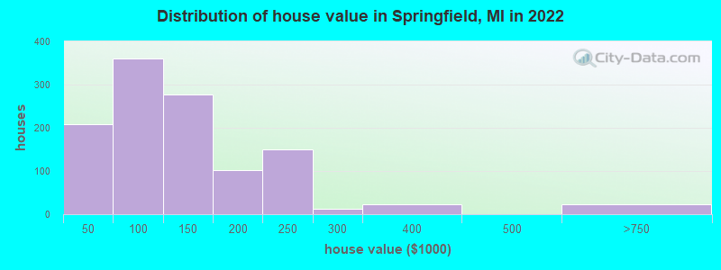
Estimated median house or condo value in 2022: $104,914 (it was $57,200 in 2000)
| Springfield: | $104,914 |
| MI: | $224,400 |
Mean prices in 2022: all housing units: $112,150; detached houses: $131,914; townhouses or other attached units: $124,011; mobile homes: $11,451
Median gross rent in 2022: $751.
(27.5% for White Non-Hispanic residents, 10.8% for Black residents, 14.3% for American Indian residents, 55.1% for two or more races residents)
Detailed information about poverty and poor residents in Springfield, MI
Compare current foreclosures near Springfield, MI:
| Photo | Address | Area | Beds / Baths | Price | Details |
|---|---|---|---|---|---|

|
#1
Clark St
Battle Creek, MI 49014
|
1,096 sq. feet
|
1 baths 2 beds |
$161,500
|
show details |

|
#2
Lyons Ave
Kalamazoo, MI 49048
|
1,560 sq. feet
|
2 baths 3 beds |
$255,000
|
show details |

|
#3
N 42nd St
Augusta, MI 49012
|
1,289 sq. feet
|
1 baths 3 beds |
show details | |

|
#4
N La Vista Blvd
Battle Creek, MI 49015
|
1,729 sq. feet
|
1 baths 3 beds |
show details | |

|
#5
Princeton St N
Battle Creek, MI 49014
|
832 sq. feet
|
1 baths 2 beds |
show details | |

|
#6
Pepperidge Ln
Battle Creek, MI 49015
|
1,066 sq. feet
|
1 baths 3 beds |
show details | |

|
#7
Review Ave
Battle Creek, MI 49037
|
1,394 sq. feet
|
1 baths 2 beds |
show details | |

|
#8
Watkins Ln
Battle Creek, MI 49015
|
2,338 sq. feet
|
3 baths 6 beds |
show details | |

|
#9
Loon Lake Dr
Bellevue, MI 49021
|
1,953 sq. feet
|
2 baths 4 beds |
show details | |

|
#10
Broad St N
Battle Creek, MI 49017
|
1,461 sq. feet
|
1 baths 4 beds |
show details |
| Photo | Address | Area | Beds / Baths | Price | Details |
|---|---|---|---|---|---|

|
#11
Jetson Dr
Climax, MI 49034
|
1,379 sq. feet
|
2 baths 3 beds |
show details | |

|
#12
Burnham St W
Battle Creek, MI 49015
|
1,148 sq. feet
|
2 baths 2 beds |
show details | |

|
#13
S Williams St
Bellevue, MI 49021
|
2,121 sq. feet
|
2 baths 3 beds |
show details | |

|
#14
Eldred St
Battle Creek, MI 49015
|
1,283 sq. feet
|
1 baths 3 beds |
show details | |

|
#15
S Capital Ave
Athens, MI 49011
|
1,148 sq. feet
|
1 baths 3 beds |
show details | |

|
#16
Bard Ave
Kalamazoo, MI 49004
|
1,404 sq. feet
|
2 baths 3 beds |
show details | |

|
#17
Brizse Ave
Battle Creek, MI 49037
|
969 sq. feet
|
1 baths 3 beds |
show details | |

|
#18
Upton Ave
Battle Creek, MI 49037
|
1,632 sq. feet
|
2 baths 4 beds |
show details | |

|
#19
Lawrence Rd
Nashville, MI 49073
|
2,560 sq. feet
|
2 baths 5 beds |
show details | |

|
#20
N Dr S
Burlington, MI 49029
|
1,854 sq. feet
|
2 baths 3 beds |
show details |
| Photo | Address | Area | Beds / Baths | Price | Details |
|---|---|---|---|---|---|

|
#21
21st St N
Battle Creek, MI 49015
|
720 sq. feet
|
1 baths 2 beds |
show details | |

|
#22
Hamblin Ave W
Battle Creek, MI 49037
|
851 sq. feet
|
1 baths 2 beds |
show details | |

|
#23
Thorncroft Ave
Battle Creek, MI 49017
|
1,292 sq. feet
|
1 baths 3 beds |
show details | |

|
#24
Lamora Ave
Battle Creek, MI 49037
|
- sq. feet
|
1 baths 2 beds |
show details | |

|
#25
G Ave
Kalamazoo, MI 49048
|
- sq. feet
|
1 baths 3 beds |
show details | |

|
#26
Swedish Dr
Battle Creek, MI 49037
|
- sq. feet
|
1 baths 2 beds |
show details | |

|
#27
Henning St
Kalamazoo, MI 49048
|
- sq. feet
|
1 baths 2 beds |
show details | |

|
#28
Lakeshire Rd
Battle Creek, MI 49015
|
- sq. feet
|
2 baths 4 beds |
show details | |

|
#29
E South St
Athens, MI 49011
|
- sq. feet
|
2 baths 4 beds |
show details | |

|
#30
S B Ave
Athens, MI 49011
|
- sq. feet
|
1 baths 3 beds |
show details |
| Photo | Address | Area | Beds / Baths | Price | Details |
|---|---|---|---|---|---|

|
#31
W Capital Ave
Bellevue, MI 49021
|
- sq. feet
|
2 baths 3 beds |
show details | |

|
#32
Sheffield Rd
Battle Creek, MI 49017
|
1,560 sq. feet
|
1 baths 3 beds |
show details | |

|
#33
Circle Dr
Marshall, MI 49068
|
- sq. feet
|
1 baths 3 beds |
show details | |

|
#34
Keyes Rd
Bellevue, MI 49021
|
1,060 sq. feet
|
1 baths - beds |
show details | |

|
#35
Larkwood Ct Apt 1b
Kalamazoo, MI 49048
|
- sq. feet
|
- baths - beds |
show details | |

|
#36
Sandalwood Dr Apt 3b
Kalamazoo, MI 49048
|
- sq. feet
|
- baths - beds |
show details | |

|
#37
Kincaid St
Kalamazoo, MI 49048
|
- sq. feet
|
- baths - beds |
show details | |

|
#38
Berry St
Kalamazoo, MI 49048
|
- sq. feet
|
- baths - beds |
show details | |

|
#39
Gull Prairie Dr Apt 1b
Kalamazoo, MI 49048
|
- sq. feet
|
- baths - beds |
show details | |

|
#40
Indian Rd
Battle Creek, MI 49017
|
- sq. feet
|
- baths - beds |
show details |
| Photo | Address | Area | Beds / Baths | Price | Details |
|---|---|---|---|---|---|

|
#41
Claxton St # 449
Kalamazoo, MI 49048
|
- sq. feet
|
- baths - beds |
show details | |

|
#42
Stiles St
Battle Creek, MI 49014
|
- sq. feet
|
- baths - beds |
show details | |

|
#43
Gull Prairie Way
Kalamazoo, MI 49048
|
- sq. feet
|
- baths - beds |
show details | |

|
#44
Meadowstone Dr Apt A
Kalamazoo, MI 49048
|
- sq. feet
|
- baths - beds |
show details | |

|
#45
Wagner Dr Apt 12
Battle Creek, MI 49017
|
- sq. feet
|
- baths - beds |
show details | |

|
#46
E Michigan Ave Apt 427
Marshall, MI 49068
|
- sq. feet
|
- baths - beds |
show details | |

|
#47
Academy St
Battle Creek, MI 49014
|
- sq. feet
|
- baths - beds |
show details | |

|
#48
Capital Ave Ne, Apt 8
Battle Creek, MI 49017
|
- sq. feet
|
- baths - beds |
show details | |

|
#49
O Dr S
Burlington, MI 49029
|
- sq. feet
|
- baths - beds |
show details | |

|
Check over 1 million property listings on Foreclosure.com!
|
browse all offers | |||


- 3,48866.6%White alone
- 58011.1%Asian alone
- 4699.0%Black alone
- 4278.2%Two or more races
- 2755.2%Hispanic
- 210.4%American Indian alone
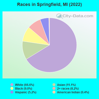
Races in Springfield detailed stats: ancestries, foreign born residents, place of birth
According to our research of Michigan and other state lists, there were 35 registered sex offenders living in Springfield, Michigan as of April 27, 2024.
The ratio of all residents to sex offenders in Springfield is 149 to 1.
 Recent articles from our blog. Our writers, many of them Ph.D. graduates or candidates, create easy-to-read articles on a wide variety of topics.

 | What Suburbs Are On The Rise? (70 replies) |
| Will Detroit ever build a subway line? Just one? Like ever? (56 replies) |
| From Arlington, VA to Michigan (15 replies) |
| Why Didn't Grand Rapids Decline? (74 replies) |
| Top city's in MI (36 replies) |
| sault ste marie (120 replies) |
Latest news from Springfield, MI collected exclusively by city-data.com from local newspapers, TV, and radio stations
Ancestries: American (12.2%), Irish (10.3%), Polish (8.6%), German (7.5%), English (5.1%), Dutch (2.0%).
Current Local Time: EST time zone
Land area: 3.72 square miles.
Population density: 1,417 people per square mile (low).
546 residents are foreign born (7.7% Asia, 1.8% Latin America).
| This city: | 10.4% |
| Michigan: | 6.9% |
Median real estate property taxes paid for housing units with mortgages in 2022: $1,633 (1.5%)
Median real estate property taxes paid for housing units with no mortgage in 2022: $2,082 (2.2%)
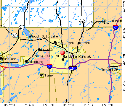
Nearest city with pop. 50,000+: Battle Creek, MI  (1.6 miles , pop. 53,364).
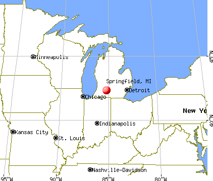
Nearest city with pop. 200,000+: Fort Wayne, IN (86.3 miles , pop. 205,727).
Nearest city with pop. 1,000,000+: Chicago, IL (130.1 miles , pop. 2,896,016).
Nearest cities:
), ), ), ), )Latitude: 42.32 N, Longitude: 85.23 W
Daytime population change due to commuting: -46 (-0.9%)
Workers who live and work in this city: 131 (5.8%)
Area code commonly used in this area: 269

Springfield, Michigan accommodation & food services, waste management - Economy and Business Data
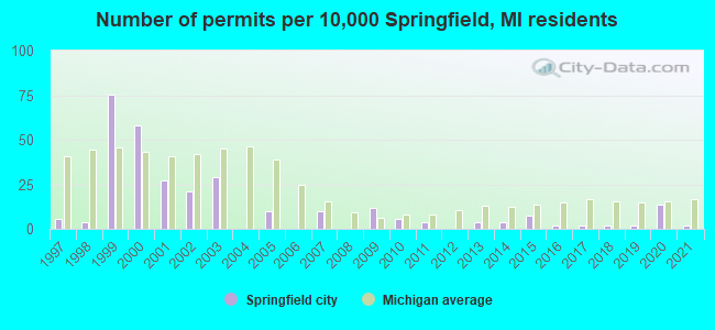
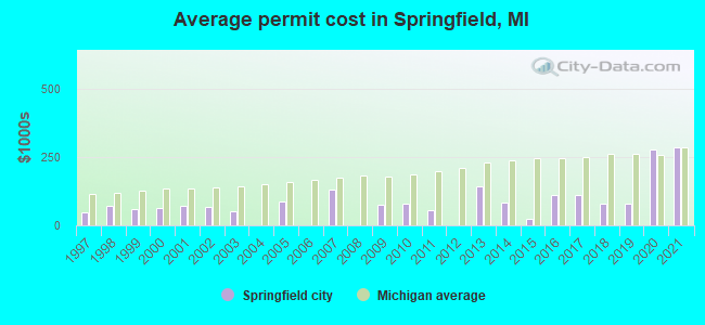
Single-family new house construction building permits:
- 2021: 1 building, cost: $285,000
- 2020: 7 buildings, average cost: $278,400
- 2019: 1 building, cost: $80,000
- 2018: 1 building, cost: $80,000
- 2017: 1 building, cost: $110,000
- 2016: 1 building, cost: $110,000
- 2015: 4 buildings, average cost: $25,000
- 2014: 2 buildings, average cost: $82,000
- 2013: 2 buildings, average cost: $142,400
- 2011: 2 buildings, average cost: $55,500
- 2010: 3 buildings, average cost: $81,300
- 2009: 6 buildings, average cost: $74,500
- 2007: 5 buildings, average cost: $131,000
- 2005: 5 buildings, average cost: $89,000
- 2003: 15 buildings, average cost: $53,000
- 2002: 11 buildings, average cost: $68,800
- 2001: 14 buildings, average cost: $72,300
- 2000: 30 buildings, average cost: $63,400
- 1999: 39 buildings, average cost: $60,400
- 1998: 2 buildings, average cost: $71,500
- 1997: 3 buildings, average cost: $45,700
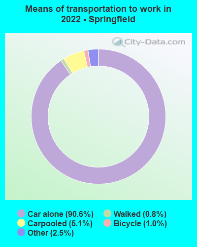
| Here: | 4.0% |
| Michigan: | 3.5% |

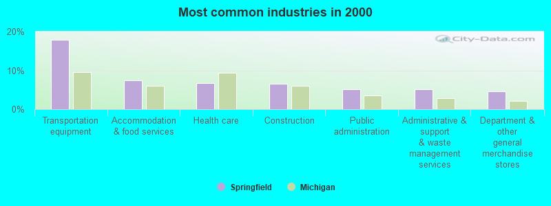
- Transportation equipment (17.9%)
- Accommodation & food services (7.5%)
- Health care (6.7%)
- Construction (6.6%)
- Public administration (5.1%)
- Administrative & support & waste management services (5.1%)
- Department & other general merchandise stores (4.7%)
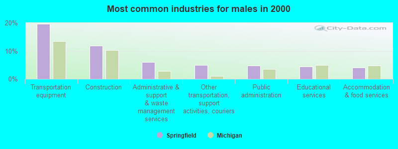
- Transportation equipment (19.6%)
- Construction (11.8%)
- Administrative & support & waste management services (6.0%)
- Other transportation, support activities, couriers (5.0%)
- Public administration (4.8%)
- Educational services (4.5%)
- Accommodation & food services (4.1%)
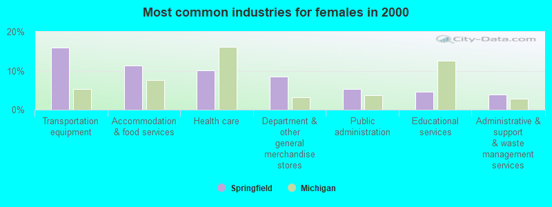
- Transportation equipment (15.9%)
- Accommodation & food services (11.4%)
- Health care (10.2%)
- Department & other general merchandise stores (8.5%)
- Public administration (5.4%)
- Educational services (4.6%)
- Administrative & support & waste management services (4.0%)
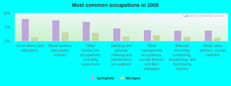
- Assemblers and fabricators (8.0%)
- Metal workers and plastic workers (7.5%)
- Other production occupations, including supervisors (7.0%)
- Building and grounds cleaning and maintenance occupations (4.6%)
- Other management occupations, except farmers and farm managers (4.0%)
- Material recording, scheduling, dispatching, and distributing workers (3.9%)
- Retail sales workers, except cashiers (3.8%)
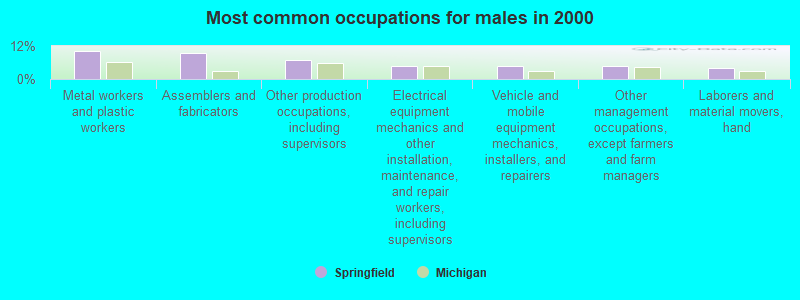
- Metal workers and plastic workers (10.1%)
- Assemblers and fabricators (9.3%)
- Other production occupations, including supervisors (6.8%)
- Electrical equipment mechanics and other installation, maintenance, and repair workers, including supervisors (4.8%)
- Vehicle and mobile equipment mechanics, installers, and repairers (4.7%)
- Other management occupations, except farmers and farm managers (4.6%)
- Laborers and material movers, hand (4.0%)
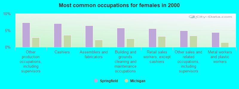
- Other production occupations, including supervisors (7.3%)
- Cashiers (7.1%)
- Assemblers and fabricators (6.5%)
- Building and grounds cleaning and maintenance occupations (5.7%)
- Retail sales workers, except cashiers (5.5%)
- Other sales and related occupations, including supervisors (5.0%)
- Metal workers and plastic workers (4.4%)
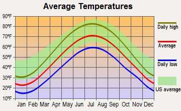
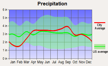
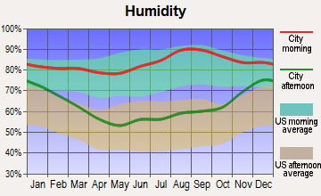
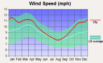
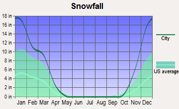
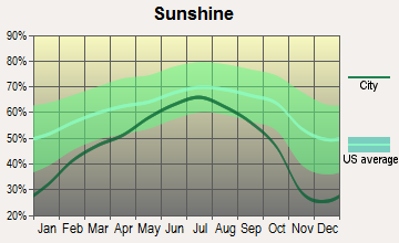
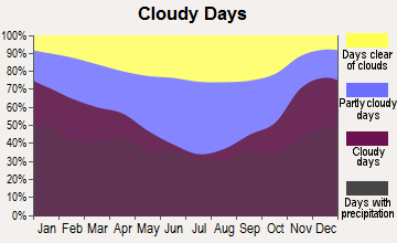
Average climate in Springfield, Michigan
Based on data reported by over 4,000 weather stations
(lower is better)
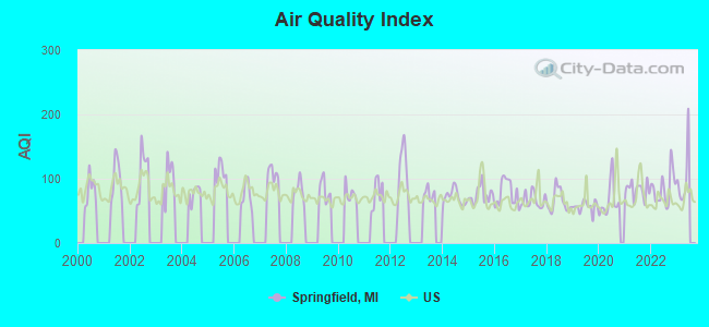
Air Quality Index (AQI) level in 2022 was 85.5. This is about average.
| City: | 85.5 |
| U.S.: | 72.6 |
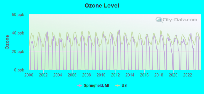
Ozone [ppb] level in 2022 was 30.6. This is about average. Closest monitor was 9.1 miles away from the city center.
| City: | 30.6 |
| U.S.: | 33.3 |
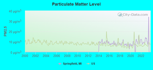
Particulate Matter (PM2.5) [µg/m3] level in 2022 was 10.3. This is worse than average. Closest monitor was 16.2 miles away from the city center.
| City: | 10.3 |
| U.S.: | 8.1 |
Tornado activity:
Springfield-area historical tornado activity is above Michigan state average. It is 54% greater than the overall U.S. average.
On 4/2/1977, a category F4 (max. wind speeds 207-260 mph) tornado 4.9 miles away from the Springfield city center injured 10 people and caused between $500,000 and $5,000,000 in damages.
On 4/2/1977, a category F4 tornado 13.0 miles away from the city center killed one person and injured 44 people and caused between $500,000 and $5,000,000 in damages.
Earthquake activity:
Springfield-area historical earthquake activity is significantly above Michigan state average. It is 21% smaller than the overall U.S. average.On 5/2/2015 at 16:23:07, a magnitude 4.2 (4.2 MW, Depth: 2.8 mi, Class: Light, Intensity: IV - V) earthquake occurred 11.8 miles away from Springfield center
On 1/31/1986 at 16:46:43, a magnitude 5.0 (5.0 MB, Class: Moderate, Intensity: VI - VII) earthquake occurred 215.2 miles away from the city center
On 9/25/1998 at 19:52:52, a magnitude 5.2 (4.8 MB, 4.3 MS, 5.2 LG, 4.5 MW, Depth: 3.1 mi) earthquake occurred 255.4 miles away from the city center
On 4/18/2008 at 09:36:59, a magnitude 5.4 (5.1 MB, 4.8 MS, 5.4 MW, 5.2 MW) earthquake occurred 302.1 miles away from Springfield center
On 7/12/1986 at 08:19:37, a magnitude 4.5 (4.5 MB) earthquake occurred 131.4 miles away from the city center
On 7/27/1980 at 18:52:21, a magnitude 5.2 (5.1 MB, 4.7 MS, 5.0 UK, 5.2 UK) earthquake occurred 292.9 miles away from the city center
Magnitude types: regional Lg-wave magnitude (LG), body-wave magnitude (MB), surface-wave magnitude (MS), moment magnitude (MW)
Natural disasters:
The number of natural disasters in Calhoun County (8) is smaller than the US average (15).Major Disasters (Presidential) Declared: 3
Emergencies Declared: 4
Causes of natural disasters: Storms: 3, Floods: 2, Blizzard: 1, Freeze: 1, Hurricane: 1, Power Outage: 1, Snowstorm: 1, Wind: 1, Winter Storm: 1, Other: 1 (Note: some incidents may be assigned to more than one category).

Hospitals and medical centers near Springfield:
- LAKEVIEW GENERAL HOSPITAL (Hospital, about 2 miles away; BATTLE CREEK, MI)
- EVERGREEN MANOR SENIOR CARE CE (Nursing Home, about 2 miles away; BATTLE CREEK, MI)
- LAURELS OF BEDFORD (THE) (Nursing Home, about 2 miles away; BATTLE CREEK, MI)
- BEHAVIORAL HLTH CTR OF BATTLE CREEK (Hospital, about 3 miles away; BATTLE CREEK, MI)
- FIELDSTONE CTR OF BATTLE CRK HLTH SYS (Hospital, about 3 miles away; BATTLE CREEK, MI)
- WESTBROOK HOSPITAL (Hospital, about 3 miles away; BATTLE CREEK, MI)
- BRONSON BATTLE CREEK HOSPITAL Acute Care Hospitals (about 3 miles away; BATTLE CREEK, MI)
Amtrak stations near Springfield:
- 3 miles: BATTLE CREEK (104 CAPITAL AVE. SW) . Services: ticket office, partially wheelchair accessible, enclosed waiting area, public restrooms, public payphones, vending machines, free short-term parking, free long-term parking, taxi stand, intercity bus service, public transit connection.
- 19 miles: KALAMAZOO (459 N. BURDICK ST.) . Services: ticket office, fully wheelchair accessible, enclosed waiting area, public restrooms, public payphones, snack bar, paid short-term parking, paid long-term parking, call for car rental service, taxi stand, intercity bus service.
Colleges/universities with over 2000 students nearest to Springfield:
- Kellogg Community College (about 3 miles; Battle Creek, MI; Full-time enrollment: 4,078)
- Western Michigan University (about 20 miles; Kalamazoo, MI; FT enrollment: 20,840)
- Kalamazoo Valley Community College (about 25 miles; Kalamazoo, MI; FT enrollment: 7,369)
- Spring Arbor University (about 36 miles; Spring Arbor, MI; FT enrollment: 3,374)
- Davenport University (about 40 miles; Grand Rapids, MI; FT enrollment: 6,955)
- Jackson College (about 44 miles; Jackson, MI; FT enrollment: 4,258)
- Lansing Community College (about 45 miles; Lansing, MI; FT enrollment: 12,822)
Public elementary/middle schools in Springfield:
- SPRINGFIELD MIDDLE SCHOOL (Students: 397, Location: 1023 AVENUE A, Grades: 6-8)
- VALLEY VIEW ELEMENTARY SCHOOL (Students: 371, Location: 960 AVENUE A, Grades: PK-5)
- BATTLE CREEK MONTESSORI ACADEMY (Location: 399 20TH ST N, Grades: KG-8, Charter school)
Points of interest:
Notable locations in Springfield: Springbrook Golf Course (A), Springfield Police Department (B), Springfield Department of Public Safety Fire Station (C). Display/hide their locations on the map
Churches in Springfield include: Church of God of Prophecy (A), Springfield Assembly of God Church (B), Abundant Grace Covenant Church (C). Display/hide their locations on the map
Cemetery: Reese Cemetery (1). Display/hide its location on the map
Lake: Lawrence Lake (A). Display/hide its location on the map
| This city: | 2.4 people |
| Michigan: | 2.5 people |
| This city: | 56.3% |
| Whole state: | 66.0% |
| This city: | 10.9% |
| Whole state: | 6.4% |
Likely homosexual households (counted as self-reported same-sex unmarried-partner households)
- Lesbian couples: 0.4% of all households
- Gay men: 0.3% of all households
29 people in group homes intended for adults in 2010
People in group quarters in Springfield in 2000:
- 191 people in other noninstitutional group quarters
- 127 people in other group homes
- 81 people in nursing homes
- 6 people in homes for the mentally ill
- 5 people in homes or halfway houses for drug/alcohol abuse
For population 15 years and over in Springfield:
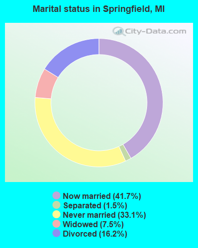
- Never married: 33.1%
- Now married: 41.7%
- Separated: 1.5%
- Widowed: 7.5%
- Divorced: 16.2%
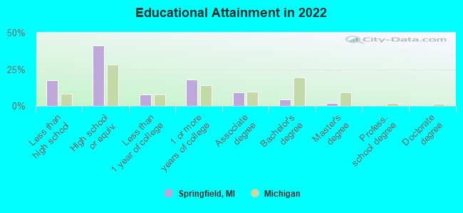
For population 25 years and over in Springfield:
- High school or higher: 81.4%
- Bachelor's degree or higher: 5.6%
- Graduate or professional degree: 1.8%
- Unemployed: 6.4%
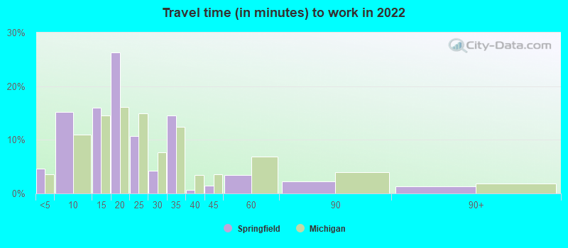
- Mean travel time to work (commute): 16.9 minutes
| Here: | 11.6 |
| Michigan average: | 11.0 |
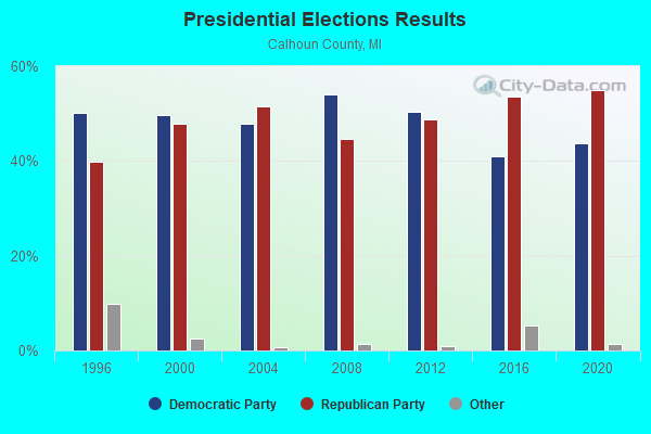
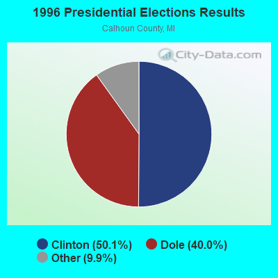
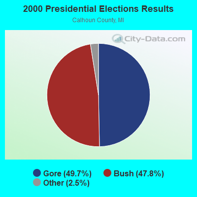
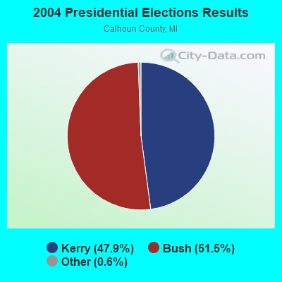
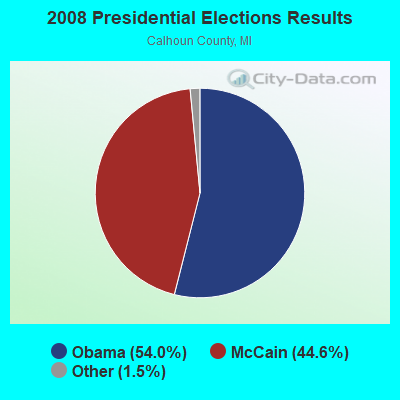
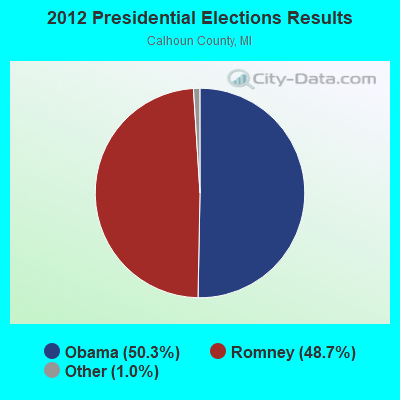
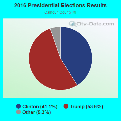
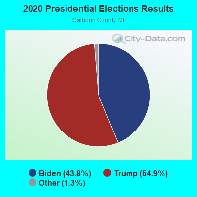
Graphs represent county-level data. Detailed 2008 Election Results
Religion statistics for Springfield, MI (based on Calhoun County data)
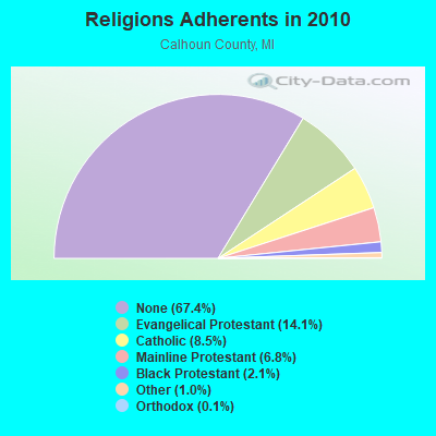

| Religion | Adherents | Congregations |
|---|---|---|
| Evangelical Protestant | 19,144 | 99 |
| Catholic | 11,553 | 6 |
| Mainline Protestant | 9,293 | 45 |
| Black Protestant | 2,882 | 12 |
| Other | 1,337 | 10 |
| Orthodox | 180 | 2 |
| None | 91,757 | - |
Food Environment Statistics:
| Calhoun County: | 1.91 / 10,000 pop. |
| State: | 2.34 / 10,000 pop. |
| Calhoun County: | 0.22 / 10,000 pop. |
| Michigan: | 0.18 / 10,000 pop. |
| This county: | 1.61 / 10,000 pop. |
| Michigan: | 1.52 / 10,000 pop. |
| Calhoun County: | 4.03 / 10,000 pop. |
| State: | 2.99 / 10,000 pop. |
| Here: | 6.01 / 10,000 pop. |
| Michigan: | 6.80 / 10,000 pop. |
| Calhoun County: | 9.5% |
| Michigan: | 9.7% |
| Here: | 30.3% |
| State: | 29.7% |
| Calhoun County: | 14.4% |
| State: | 13.4% |
Health and Nutrition:
| Here: | 47.8% |
| Michigan: | 50.3% |
| This city: | 42.8% |
| Michigan: | 47.9% |
| Here: | 28.7 |
| State: | 28.7 |
| This city: | 20.9% |
| Michigan: | 20.6% |
| Springfield: | 11.9% |
| Michigan: | 10.4% |
| Springfield: | 6.8 |
| Michigan: | 6.8 |
| Here: | 31.6% |
| Michigan: | 34.1% |
| This city: | 54.5% |
| State: | 57.0% |
| This city: | 77.8% |
| Michigan: | 79.6% |
More about Health and Nutrition of Springfield, MI Residents
| Local government employment and payroll (March 2022) | |||||
| Function | Full-time employees | Monthly full-time payroll | Average yearly full-time wage | Part-time employees | Monthly part-time payroll |
|---|---|---|---|---|---|
| Financial Administration | 8 | $39,147 | $58,721 | 0 | $0 |
| Other Government Administration | 2 | $13,132 | $78,792 | 0 | $0 |
| Water Supply | 2 | $8,722 | $52,332 | 0 | $0 |
| Other and Unallocable | 1 | $3,624 | $43,488 | 0 | $0 |
| Parks and Recreation | 1 | $4,452 | $53,424 | 0 | $0 |
| Streets and Highways | 1 | $4,874 | $58,488 | 0 | $0 |
| Police - Other | 0 | $0 | 2 | $709 | |
| Firefighters | 0 | $0 | 8 | $3,526 | |
| Totals for Government | 15 | $73,950 | $59,160 | 10 | $4,235 |
Springfield government finances - Expenditure in 2017 (per resident):
- Current Operations - Sewerage: $1,477,000 ($280.48)
Regular Highways: $1,100,000 ($208.89)
Police Protection: $1,065,000 ($202.24)
Financial Administration: $528,000 ($100.27)
General - Other: $502,000 ($95.33)
Solid Waste Management: $218,000 ($41.40)
Local Fire Protection: $199,000 ($37.79)
Central Staff Services: $196,000 ($37.22)
Parks and Recreation: $106,000 ($20.13)
General Public Buildings: $43,000 ($8.17)
Protective Inspection and Regulation - Other: $37,000 ($7.03)
- General - Interest on Debt: $58,000 ($11.01)
- Intergovernmental to Local - Other - Police Protection: $909,000 ($172.62)
Other - Sewerage: $566,000 ($107.48)
Other - General - Other: $279,000 ($52.98)
Other - Financial Administration: $48,000 ($9.12)
- Intergovernmental to State - General - Other: $7,000 ($1.33)
Financial Administration: $2,000 ($0.38)
- Other Capital Outlay - General - Other: $27,000 ($5.13)
Parks and Recreation: $7,000 ($1.33)
Sewerage: $4,000 ($0.76)
Water Utilities: $4,000 ($0.76)
- Total Salaries and Wages: $831,000 ($157.80)
- Water Utilities - Interest on Debt: $2,000 ($0.38)
Springfield government finances - Revenue in 2017 (per resident):
- Charges - Sewerage: $768,000 ($145.84)
Solid Waste Management: $224,000 ($42.54)
- Local Intergovernmental - Other: $25,000 ($4.75)
- Miscellaneous - Sale of Property: $292,000 ($55.45)
General Revenue - Other: $244,000 ($46.33)
Fines and Forfeits: $65,000 ($12.34)
Interest Earnings: $29,000 ($5.51)
Special Assessments: $24,000 ($4.56)
Rents: $21,000 ($3.99)
- Revenue - Water Utilities: $642,000 ($121.91)
- State Intergovernmental - General Local Government Support: $713,000 ($135.40)
Highways: $535,000 ($101.60)
Other: $326,000 ($61.91)
- Tax - Property: $1,379,000 ($261.87)
Individual Income: $1,013,000 ($192.37)
Occupation and Business License - Other: $70,000 ($13.29)
Other License: $46,000 ($8.74)
Other Selective Sales: $1,000 ($0.19)
Springfield government finances - Debt in 2017 (per resident):
- Long Term Debt - Beginning Outstanding - Unspecified Public Purpose: $1,490,000 ($282.95)
Retired Unspecified Public Purpose: $1,463,000 ($277.82)
Outstanding Unspecified Public Purpose: $1,332,000 ($252.94)
Issue, Unspecified Public Purpose: $1,305,000 ($247.82)
Springfield government finances - Cash and Securities in 2017 (per resident):
- Other Funds - Cash and Securities: $5,414,000 ($1028.10)
Businesses in Springfield, MI
- Honda: 1
- Ryder Rental & Truck Leasing: 1
- UPS: 1
Strongest AM radio stations in Springfield:
- WBCK (930 AM; 5 kW; BATTLE CREEK, MI; Owner: CAPSTAR TX LIMITED PARTNERSHIP)
- WRCC (1400 AM; 1 kW; BATTLE CREEK, MI; Owner: CASPTAR TX LIMITED PARTNERSHIP)
- WOLY (1500 AM; daytime; 1 kW; BATTLE CREEK, MI; Owner: CHRISTIAN FAMILY NETWORK, INC.)
- WKZO (590 AM; 5 kW; KALAMAZOO, MI; Owner: FAIRFIELD BROADCASTING COMPANY)
- WKLZ (1470 AM; 10 kW; KALAMAZOO, MI; Owner: FAIRFIELD BROADCASTING COMPANY)
- WQSN (1660 AM; 10 kW; KALAMAZOO, MI; Owner: FAIRFIELD BROADCASTING COMPANY)
- WKMI (1360 AM; 5 kW; KALAMAZOO, MI)
- WOAP (1080 AM; 50 kW; OWOSSO, MI)
- WOOD (1300 AM; 20 kW; GRAND RAPIDS, MI; Owner: CLEAR CHANNEL BROADCASTING LICENSES, INC.)
- WNWN (1560 AM; daytime; 4 kW; PORTAGE, MI; Owner: MIDWEST COMMUNICATIONS, INC)
- WJR (760 AM; 50 kW; DETROIT, MI; Owner: ABC, INC.)
- WFDF (910 AM; 50 kW; FLINT, MI; Owner: ABC, INC.)
- WLCM (1390 AM; 5 kW; CHARLOTTE, MI)
Strongest FM radio stations in Springfield:
- WKFR-FM (103.3 FM; BATTLE CREEK, MI; Owner: CUMULUS LICENSING CORP.)
- WBXX (95.3 FM; BATTLE CREEK, MI; Owner: CASPTAR TX LIMITED PARTNERSHIP)
- W223AE (92.5 FM; BATTLE CREEK, MI; Owner: SPRING ARBOR COLLEGE COMMUNICATIONS)
- WRKR (107.7 FM; PORTAGE, MI; Owner: CUMULUS LICENSING CORP.)
- WQLR (106.5 FM; KALAMAZOO, MI; Owner: FAIRFIELD BROADCASTING COMPANY)
- WMUK (102.1 FM; KALAMAZOO, MI; Owner: WESTERN MICHIGAN UNIVERSITY)
- WBCT (93.7 FM; GRAND RAPIDS, MI; Owner: CLEAR CHANNEL BROADCASTING LICENSES, INC.)
- WWKN (104.9 FM; MARSHALL, MI; Owner: CASPTAR TX LIMITED PARTNERSHIP)
- WVGR (104.1 FM; GRAND RAPIDS, MI; Owner: REGENTS OF THE UNIVERSITY OF MICHIGAN)
- WNWN-FM (98.5 FM; COLDWATER, MI; Owner: MIDWEST COMMUNICATIONS, INC)
- WOOD-FM (105.7 FM; GRAND RAPIDS, MI; Owner: CLEAR CHANNEL BROADCASTING LICENSES, INC.)
- WFPM-LP (99.5 FM; BATTLE CREEK, MI; Owner: FIRST PENTECOSTAL CHURCH OF GOD IN CHRIST)
- WAYK (88.3 FM; KALAMAZOO, MI; Owner: CORNERSTONE UNIVERSITY)
- WVIC (94.1 FM; JACKSON, MI; Owner: RUBBER CITY RADIO GROUP)
- WZUU (92.3 FM; ALLEGAN, MI; Owner: FORUM COMMUNICATIONS, INC.)
- WFAT (96.5 FM; PORTAGE, MI; Owner: MIDWEST COMMUNICATIONS, INC)
- W247AM (97.3 FM; KALAMAZOO, MI; Owner: CSN INTERNATIONAL)
- WUFN (96.7 FM; ALBION, MI; Owner: FAMILY LIFE BROADCASTING SYSTEM)
- WBCH-FM (100.1 FM; HASTINGS, MI; Owner: BARRY BROADCASTING CO.)
- W258AH (99.5 FM; KALAMAZOO, MI; Owner: SPRING ARBOR UNIVERSITY COMMUNICATIONS, INC.)
TV broadcast stations around Springfield:
- WOBC-CA (Channel 20; BATTLE CREEK, MI; Owner: WOOD LICENSE COMPANY, LLC)
- W21BS (Channel 21; HOUGHTON LAKE, MI; Owner: MS COMMUNICATIONS, LLC)
- WLLA (Channel 64; KALAMAZOO, MI; Owner: CHRISTIAN FAITH BROADCAST, INC.)
- WWMT (Channel 3; KALAMAZOO, MI; Owner: FREEDOM BROADCASTING OF MICHIGAN, INC.)
- WOTV (Channel 41; BATTLE CREEK, MI; Owner: WOOD LICENSE COMPANY, LLC)
- WZPX (Channel 43; BATTLE CREEK, MI; Owner: PAXSON BATTLE CREEK LICENSE, INC.)
- W26BX (Channel 26; KALAMAZOO, MI; Owner: TCT OF MICHIGAN, INC.)
- WXMI (Channel 17; GRAND RAPIDS, MI; Owner: TRIBUNE TELEVISION HOLDINGS, INC.)
- WOOD-TV (Channel 8; GRAND RAPIDS, MI; Owner: WOOD LICENSE COMPANY, LLC)
- WSYM-TV (Channel 47; LANSING, MI; Owner: JOURNAL BROADCAST CORPORATION)
- WILX-TV (Channel 10; ONONDAGA, MI; Owner: GRAY MIDAMERICA TV LICENSEE CORP.)
- WLAJ (Channel 53; LANSING, MI; Owner: FREEDOM BROADCASTING OF MICHIGAN, INC.)
- WHTV (Channel 18; JACKSON, MI; Owner: SPARTAN-TV, L.L.C.)
- WGVK (Channel 52; KALAMAZOO, MI; Owner: GRAND VALLEY STATE UNIVERSITY)
- National Bridge Inventory (NBI) Statistics
- 1Number of bridges
- 13ft / 3.8mTotal length
- 18,057Total average daily traffic
- 902Total average daily truck traffic
- 22,801Total future (year 2018) average daily traffic
FCC Registered Antenna Towers:
28 (See the full list of FCC Registered Antenna Towers in Springfield)FCC Registered Private Land Mobile Towers:
3- 10275 Dixie Hwy (Lat: 42.774194 Lon: -83.498833), Type: Tower, Structure height: 125 m, Overall height: 123 m, Call Sign: WPGX547,
Assigned Frequencies: 929.562 MHz, Grant Date: 07/13/2000, Expiration Date: 07/13/2010, Cancellation Date: 07/09/2001, Certifier: Donna Comer, Registrant: Paging Network Of Michigan Inc, 1500 International Pkwy, Suite 300, Richardson, TX 75081, Phone: (972) 801-0304, Fax: (972) 801-0330
- D8375 E Holly Rd (Lat: 42.783917 Lon: -83.534667), Type: Tower, Structure height: 128 m, Overall height: 134 m, Call Sign: WPID621,
Assigned Frequencies: 929.662 MHz, Grant Date: 02/20/2001, Expiration Date: 09/28/2010, Cancellation Date: 03/27/2001, Registrant: Hall Estill Hardwick Gable Golden & Nels, 1120 20th St Nw N Bldg Ste 700, Washington, DC 20036, Phone: (202) 973-1210, Fax: (202) 973-1212
- D8375 E Holly Rd (Lat: 42.783917 Lon: -83.534667), Type: Tower, Structure height: 128 m, Overall height: 134 m, Call Sign: WPIG259,
Assigned Frequencies: 929.712 MHz, Grant Date: 12/06/2000, Expiration Date: 09/28/2010, Cancellation Date: 03/27/2001, Certifier: M Lambring, Registrant: Hall Estill Hardwick Gable Golden Nelson, 1120 20th St Nw N Bldg Ste 700, Washington, DC 20036, Phone: (202) 973-1210, Fax: (202) 973-1212
FCC Registered Microwave Towers:
3- STATION, Dixie Hwy At Rattalee Rd (Lat: 42.774194 Lon: -83.498806), Overall height: 128 m, Call Sign: WNTM785,
Assigned Frequencies: 6685.00 MHz, Grant Date: 01/18/2002, Expiration Date: 04/10/2012, Cancellation Date: 06/16/2012, Phone: (313) 858-1100
- 4912 Edgar Rd (Lat: 42.710028 Lon: -83.460194), Overall height: 30.5 m, Call Sign: WPJA212,
Assigned Frequencies: 928.181 MHz, 952.181 MHz, Grant Date: 03/26/1996, Expiration Date: 03/26/2001, Cancellation Date: 04/29/1997, Phone: (202) 331-9495
- Fruin, 1959 Base Ave. (Lat: 42.321417 Lon: -85.266111), Type: Tower, Structure height: 45.7 m, Overall height: 49.3 m, Call Sign: WQIQ382,
Assigned Frequencies: 6315.84 MHz, Grant Date: 04/14/2008, Expiration Date: 04/14/2018, Cancellation Date: 10/14/2009, Certifier: William Chastain, Registrant: Radio Dynamics Corporation, Silver Spring, MD 20914, Phone: (301) 493-5171, Fax: (301) 576-4553, Email:
FCC Registered Amateur Radio Licenses:
18 (See the full list of FCC Registered Amateur Radio Licenses in Springfield)FAA Registered Aircraft:
2- Aircraft: BALLOON WORKS FIREFLY 8B-15 (Category: Land, Weight: Up to 12,499 Pounds), Engine: None
N-Number: 70273, N70273, N-70273, Serial Number: F8B-564, Year manufactured: 1999, Airworthiness Date: 06/11/1999, Certificate Issue Date: 06/17/2015
Registrant (Individual): Craig A Campbell, 878 Lafayette Ave, Springfield, MI 49037 - Aircraft: CESSNA 172B (Category: Land, Seats: 4, Weight: Up to 12,499 Pounds, Speed: 105 mph), Engine: CONT MOTOR 0-300 SER (145 HP) (Reciprocating)
N-Number: 8082X, N8082X, N-8082X, Serial Number: 17248582, Year manufactured: 1961, Airworthiness Date: 06/13/1964, Certificate Issue Date: 03/21/2012
Registrant (Co-Owned): Joseph N Newman, 2869 W Dickman Rd, Springfield, MI 49037, Other Owners: Michael J Butts
| Home Mortgage Disclosure Act Aggregated Statistics For Year 1999 (Based on 1 partial tract) | ||||||||||
| A) FHA, FSA/RHS & VA Home Purchase Loans | B) Conventional Home Purchase Loans | C) Refinancings | D) Home Improvement Loans | F) Non-occupant Loans on < 5 Family Dwellings (A B C & D) | ||||||
|---|---|---|---|---|---|---|---|---|---|---|
| Number | Average Value | Number | Average Value | Number | Average Value | Number | Average Value | Number | Average Value | |
| LOANS ORIGINATED | 15 | $66,522 | 25 | $53,014 | 52 | $51,629 | 6 | $13,300 | 6 | $43,022 |
| APPLICATIONS APPROVED, NOT ACCEPTED | 0 | $0 | 7 | $33,010 | 19 | $47,988 | 6 | $20,702 | 0 | $0 |
| APPLICATIONS DENIED | 1 | $72,170 | 17 | $47,961 | 35 | $49,703 | 9 | $13,801 | 1 | $73,550 |
| APPLICATIONS WITHDRAWN | 1 | $49,270 | 2 | $29,840 | 24 | $56,726 | 0 | $0 | 1 | $47,190 |
| FILES CLOSED FOR INCOMPLETENESS | 0 | $0 | 0 | $0 | 6 | $48,805 | 0 | $0 | 0 | $0 |
| Private Mortgage Insurance Companies Aggregated Statistics For Year 1999 (Based on 1 partial tract) | ||||||
| A) Conventional Home Purchase Loans | B) Refinancings | C) Non-occupant Loans on < 5 Family Dwellings (A & B) | ||||
|---|---|---|---|---|---|---|
| Number | Average Value | Number | Average Value | Number | Average Value | |
| LOANS ORIGINATED | 6 | $43,368 | 3 | $68,697 | 1 | $21,510 |
| APPLICATIONS APPROVED, NOT ACCEPTED | 0 | $0 | 1 | $44,410 | 0 | $0 |
| APPLICATIONS DENIED | 0 | $0 | 0 | $0 | 0 | $0 |
| APPLICATIONS WITHDRAWN | 0 | $0 | 0 | $0 | 0 | $0 |
| FILES CLOSED FOR INCOMPLETENESS | 0 | $0 | 0 | $0 | 0 | $0 |
2002 - 2018 National Fire Incident Reporting System (NFIRS) incidents
- Fire incident types reported to NFIRS in Springfield, MI
- 11852.9%Structure Fires
- 4620.6%Mobile Property/Vehicle Fires
- 3013.5%Outside Fires
- 2913.0%Other
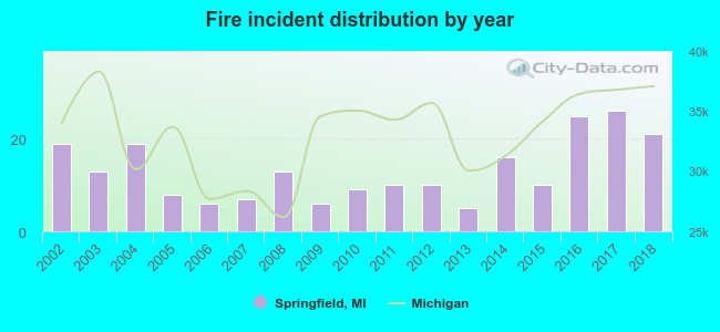 According to the data from the years 2002 - 2018 the average number of fire incidents per year is 13. The highest number of fires - 26 took place in 2017, and the least - 5 in 2013. The data has a growing trend.
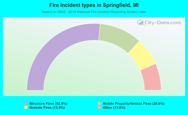 When looking into fire subcategories, the most incidents belonged to: Structure Fires (52.9%), and Mobile Property/Vehicle Fires (20.6%).
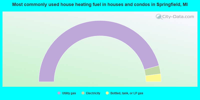
- 91.5%Utility gas
- 4.4%Electricity
- 4.1%Bottled, tank, or LP gas
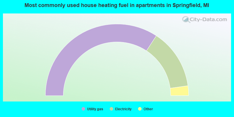
- 68.6%Utility gas
- 27.1%Electricity
- 2.0%No fuel used
- 1.1%Other fuel
- 0.8%Fuel oil, kerosene, etc.
- 0.4%Bottled, tank, or LP gas
Springfield compared to Michigan state average:
- Median household income below state average.
- Median house value below state average.
- Unemployed percentage below state average.
- Median age below state average.
- Foreign-born population percentage above state average.
- Renting percentage above state average.
- Length of stay since moving in significantly above state average.
- Percentage of population with a bachelor's degree or higher significantly below state average.
Springfield on our top lists:
- #28 on the list of "Top 101 cities with the largest percentage of people in other group homes (population 1,000+)"
- #50 on the list of "Top 101 cities with the largest percentage of people in other noninstitutional group quarters (population 1,000+)"
- #55 on the list of "Top 101 cities with largest percentage of males in occupations: production occupations (population 5,000+)"
- #73 on the list of "Top 101 cities with largest percentage of females in industries: retail trade (population 5,000+)"
- #85 on the list of "Top 101 cities with the lowest cost per building permit(population 5,000+)"
- #32 on the list of "Top 101 counties with the largest number of people moving out compared to moving in (pop. 50,000+)"