St. Mary, Kentucky
Submit your own pictures of this place and show them to the world
- OSM Map
- General Map
- Google Map
- MSN Map

| Males: 1,718 | |
| Females: 973 |
| Median resident age: | 32.9 years |
| Kentucky median age: | 35.9 years |
Zip code: 40033
| St. Mary: | $62,326 |
| KY: | $59,341 |
Estimated per capita income in 2022: $22,333 (it was $12,684 in 2000)
St. Mary CCD income, earnings, and wages data
Estimated median house or condo value in 2022: $192,684 (it was $86,500 in 2000)
| St. Mary: | $192,684 |
| KY: | $196,300 |
Mean prices in 2022: all housing units: $181,671; detached houses: $192,190; townhouses or other attached units: $814,509; mobile homes: $51,628
Detailed information about poverty and poor residents in St. Mary, KY


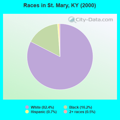
- 2,10482.4%White alone
- 41416.2%Black alone
- 170.7%Hispanic
- 140.5%Two or more races
- 20.08%American Indian alone
- 10.04%Asian alone
- 10.04%Other race alone
Races in St. Mary detailed stats: ancestries, foreign born residents, place of birth
 Recent articles from our blog. Our writers, many of them Ph.D. graduates or candidates, create easy-to-read articles on a wide variety of topics.
Current Local Time: EST time zone
Elevation: 762 feet
Land area: 34.7 square miles.
Population density: 77 people per square mile (very low).

| St. Mary CCD: | 0.6% ($537) |
| Kentucky: | 0.8% ($610) |
Nearest city with pop. 50,000+: Louisville, KY  (49.1 miles , pop. 256,231).
Nearest city with pop. 1,000,000+: Chicago, IL (318.7 miles , pop. 2,896,016).
Nearest cities:
), ), )Latitude: 37.60 N, Longitude: 85.33 W
Area code commonly used in this area: 270

| Here: | 3.0% |
| Kentucky: | 3.8% |
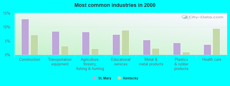
- Construction (12.9%)
- Transportation equipment (8.5%)
- Agriculture, forestry, fishing & hunting (8.3%)
- Educational services (7.4%)
- Metal & metal products (5.4%)
- Plastics & rubber products (4.3%)
- Health care (3.7%)
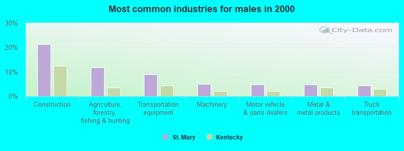
- Construction (21.3%)
- Agriculture, forestry, fishing & hunting (11.8%)
- Transportation equipment (9.0%)
- Machinery (5.0%)
- Motor vehicle & parts dealers (4.9%)
- Metal & metal products (4.7%)
- Truck transportation (4.3%)
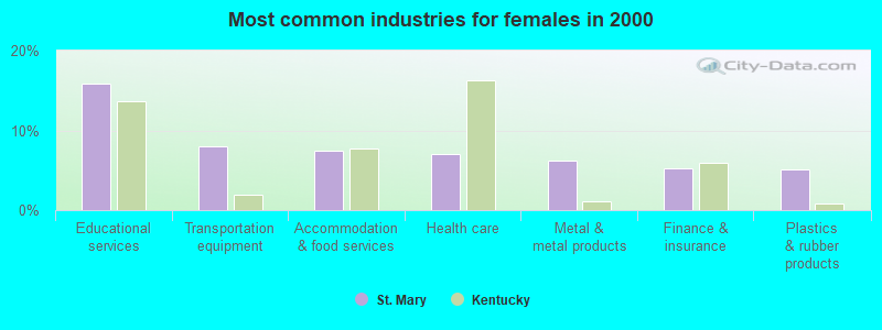
- Educational services (15.9%)
- Transportation equipment (8.0%)
- Accommodation & food services (7.5%)
- Health care (7.0%)
- Metal & metal products (6.3%)
- Finance & insurance (5.3%)
- Plastics & rubber products (5.1%)
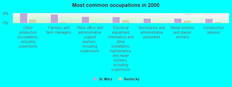
- Other production occupations, including supervisors (7.9%)
- Farmers and farm managers (7.3%)
- Other office and administrative support workers, including supervisors (5.3%)
- Electrical equipment mechanics and other installation, maintenance, and repair workers, including supervisors (5.1%)
- Secretaries and administrative assistants (4.0%)
- Metal workers and plastic workers (3.8%)
- Construction laborers (3.7%)
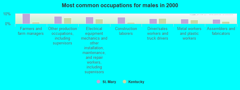
- Farmers and farm managers (9.9%)
- Other production occupations, including supervisors (7.7%)
- Electrical equipment mechanics and other installation, maintenance, and repair workers, including supervisors (6.9%)
- Construction laborers (6.5%)
- Driver/sales workers and truck drivers (5.2%)
- Metal workers and plastic workers (4.9%)
- Assemblers and fabricators (4.7%)
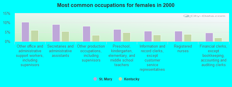
- Other office and administrative support workers, including supervisors (10.4%)
- Secretaries and administrative assistants (9.2%)
- Other production occupations, including supervisors (8.2%)
- Preschool, kindergarten, elementary, and middle school teachers (6.5%)
- Information and record clerks, except customer service representatives (5.5%)
- Registered nurses (5.5%)
- Financial clerks, except bookkeeping, accounting and auditing clerks (4.6%)
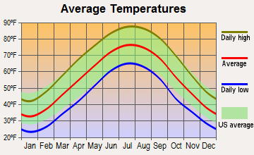
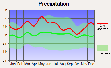
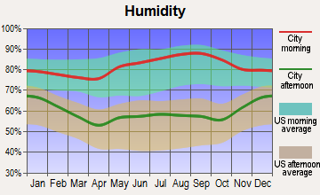
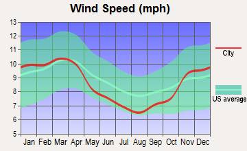
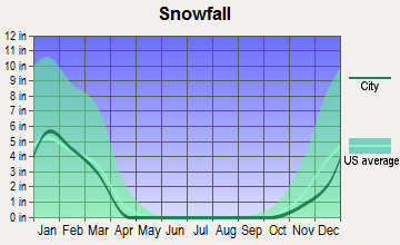
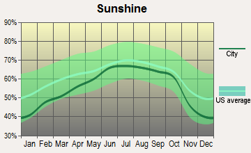
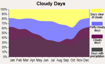
Average climate in St. Mary, Kentucky
Based on data reported by over 4,000 weather stations
Tornado activity:
St. Mary-area historical tornado activity is slightly above Kentucky state average. It is 45% greater than the overall U.S. average.
On 4/3/1974, a category F4 (max. wind speeds 207-260 mph) tornado 17.6 miles away from the St. Mary place center injured 56 people and caused between $500,000 and $5,000,000 in damages.
On 4/3/1974, a category F4 tornado 27.6 miles away from the place center killed 3 people and injured 81 people and caused between $50,000 and $500,000 in damages.
Earthquake activity:
St. Mary-area historical earthquake activity is significantly above Kentucky state average. It is 110% greater than the overall U.S. average.On 7/27/1980 at 18:52:21, a magnitude 5.2 (5.1 MB, 4.7 MS, 5.0 UK, 5.2 UK, Class: Moderate, Intensity: VI - VII) earthquake occurred 86.3 miles away from St. Mary center
On 4/18/2008 at 09:36:59, a magnitude 5.4 (5.1 MB, 4.8 MS, 5.4 MW, 5.2 MW) earthquake occurred 151.3 miles away from the city center
On 4/18/2008 at 09:36:59, a magnitude 5.2 (5.2 MW, Depth: 8.9 mi) earthquake occurred 151.3 miles away from the city center
On 6/18/2002 at 17:37:15, a magnitude 5.0 (4.3 MB, 4.6 MW, 5.0 LG) earthquake occurred 136.7 miles away from the city center
On 6/10/1987 at 23:48:54, a magnitude 5.1 (4.9 MB, 4.4 MS, 4.6 MS, 5.1 LG) earthquake occurred 162.6 miles away from St. Mary center
On 9/7/1988 at 02:28:09, a magnitude 4.6 (4.5 MB, 4.6 LG, Class: Light, Intensity: IV - V) earthquake occurred 87.5 miles away from St. Mary center
Magnitude types: regional Lg-wave magnitude (LG), body-wave magnitude (MB), surface-wave magnitude (MS), moment magnitude (MW)
Natural disasters:
The number of natural disasters in Marion County (14) is near the US average (15).Major Disasters (Presidential) Declared: 9
Emergencies Declared: 3
Causes of natural disasters: Floods: 8, Storms: 7, Tornadoes: 4, Winter Storms: 3, Mudslides: 2, Winds: 2, Blizzard: 1, Freeze: 1, Hurricane: 1, Landslide: 1, Snow: 1, Snowfall: 1, Other: 1 (Note: some incidents may be assigned to more than one category).
Hospitals and medical centers near St. Mary:
- SPRING VIEW HOSPITAL Acute Care Hospitals (about 5 miles away; LEBANON, KY)
- THE VILLAGE OF LEBANON II (Nursing Home, about 5 miles away; LEBANON, KY)
- CEDARS OF LEBANON REST HOME (Nursing Home, about 5 miles away; LEBANON, KY)
- CEDARS OF LEBANON NURSING CENTER (Nursing Home, about 5 miles away; LEBANON, KY)
- FMC - LEBANON MARION COUNTY (Dialysis Facility, about 6 miles away; LEBANON, KY)
- MEDCO CENTER OF SPRINGFIELD (Nursing Home, about 9 miles away; SPRINGFIELD, KY)
- SPRINGFIELD NURSING AND REHABILITATION CENTER (Nursing Home, about 9 miles away; SPRINGFIELD, KY)
Colleges/universities with over 2000 students nearest to St. Mary:
- Campbellsville University (about 18 miles; Campbellsville, KY; Full-time enrollment: 2,948)
- Elizabethtown Community and Technical College (about 31 miles; Elizabethtown, KY; FT enrollment: 3,762)
- Lindsey Wilson College (about 35 miles; Columbia, KY; FT enrollment: 2,552)
- Sullivan University (about 47 miles; Louisville, KY; FT enrollment: 5,129)
- Bellarmine University (about 48 miles; Louisville, KY; FT enrollment: 3,180)
- University of Louisville (about 49 miles; Louisville, KY; FT enrollment: 16,640)
- Kentucky State University (about 49 miles; Frankfort, KY; FT enrollment: 2,112)
Points of interest:
Notable location: Cornucopia Institute (A). Display/hide its location on the map
Church in St. Mary: Stewarts Creek Church (A). Display/hide its location on the map
Cemetery: Saint Charles Cemetery (1). Display/hide its location on the map
Streams, rivers, and creeks: Crab Run (A), Cissels Creek (B). Display/hide their locations on the map
| This place: | 2.7 people |
| Kentucky: | 2.5 people |
| This place: | 77.2% |
| Whole state: | 66.9% |
| This place: | 6.3% |
| Whole state: | 6.4% |
No gay or lesbian households reported
| This place: | 7.1% |
| Whole state: | 15.8% |
| This place: | 1.3% |
| Whole state: | 6.6% |
2 people in other noninstitutional facilities in 2010
688 people in state prisons in 2000
For population 15 years and over in St. Mary:
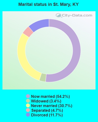
- Never married: 30.7%
- Now married: 54.2%
- Separated: 4.7%
- Widowed: 3.4%
- Divorced: 11.7%
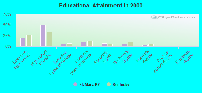
For population 25 years and over in St. Mary:
- High school or higher: 79.3%
- Bachelor's degree or higher: 8.5%
- Graduate or professional degree: 3.3%
- Unemployed: 3.9%
- Mean travel time to work (commute): 27.4 minutes
| Here: | 9.4 |
| Kentucky average: | 13.8 |
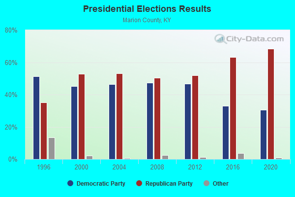
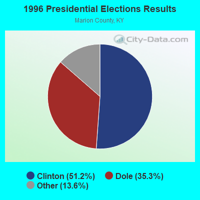
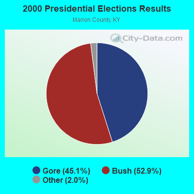
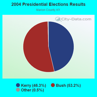
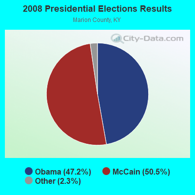
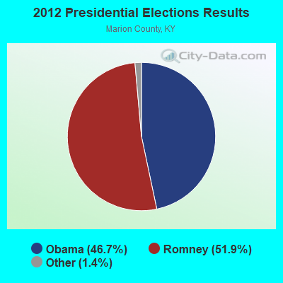
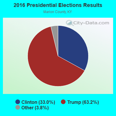
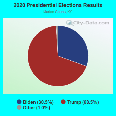
Graphs represent county-level data. Detailed 2008 Election Results
Religion statistics for St. Mary, KY (based on Marion County data)
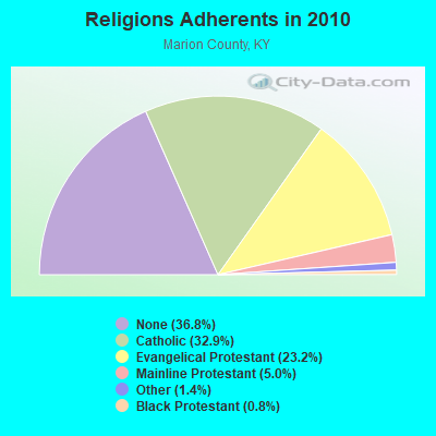
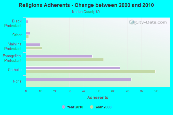
| Religion | Adherents | Congregations |
|---|---|---|
| Catholic | 6,511 | 7 |
| Evangelical Protestant | 4,601 | 19 |
| Mainline Protestant | 988 | 9 |
| Other | 269 | 1 |
| Black Protestant | 163 | 2 |
| None | 7,288 | - |
Food Environment Statistics:
| This county: | 2.65 / 10,000 pop. |
| Kentucky: | 2.19 / 10,000 pop. |
| Marion County: | 7.41 / 10,000 pop. |
| Kentucky: | 4.36 / 10,000 pop. |
| Marion County: | 5.82 / 10,000 pop. |
| State: | 5.74 / 10,000 pop. |
| This county: | 11.0% |
| State: | 11.0% |
| Marion County: | 30.7% |
| State: | 30.0% |
| Marion County: | 18.6% |
| Kentucky: | 15.9% |
Strongest AM radio stations in St. Mary:
- WLBN (1590 AM; 1 kW; LEBANON, KY; Owner: CBC OF MARION COUNTY, INC)
- WHAS (840 AM; 50 kW; LOUISVILLE, KY; Owner: CLEAR CHANNEL BROADCASTING LICENSES, INC.)
- WLW (700 AM; 50 kW; CINCINNATI, OH; Owner: JACOR BROADCASTING CORPORATION)
- WSM (650 AM; 50 kW; NASHVILLE, TN; Owner: GAYLORD ENTERTAINMENT COMPANY)
- WXXA (790 AM; 5 kW; LOUISVILLE, KY)
- WKVL (850 AM; daytime; 50 kW; KNOXVILLE, TN; Owner: HORNE RADIO, LLC)
- WKJK (1080 AM; 10 kW; LOUISVILLE, KY; Owner: CLEAR CHANNEL BROADCASTING LICENSES, INC.)
- WSAI (1530 AM; 50 kW; CINCINNATI, OH; Owner: JACOR BROADCASTING CORPORATION)
- WAMB (1160 AM; 50 kW; DONELSON, TN; Owner: GREAT SOUTHERN BROADCASTING COMPANY, INC.)
- WVLK (590 AM; 5 kW; LEXINGTON, KY; Owner: CUMULUS LICENSING CORP.)
- WBRT (1320 AM; 1 kW; BARDSTOWN, KY; Owner: CBC OF NELSON COUNTY, INC.)
- WKDA (1200 AM; 50 kW; NASHVILLE, TN; Owner: RADIO NASHVILLE, INC.)
- WNQM (1300 AM; 50 kW; NASHVILLE, TN; Owner: WNQM. INC.)
Strongest FM radio stations in St. Mary:
- WAKY-FM (102.7 FM; SPRINGFIELD, KY; Owner: WASHINGTON COUNTY CBC, INC.)
- WLSK (100.9 FM; LEBANON, KY; Owner: CBC OF MARION COUNTY, INC)
- WVLC (99.9 FM; MANNSVILLE, KY; Owner: PATRICIA RODGERS)
- WXKY-FM (96.3 FM; STANFORD, KY; Owner: LINCOLN-GARRARD BROADCASTING CO.,INC)
- WCKQ (104.1 FM; CAMPBELLSVILLE, KY; Owner: CBC OF MARION & TAYLOR COUNTIES INC)
- WASE (103.5 FM; RADCLIFF, KY; Owner: W & B BROADCASTING, INC.)
- WKUE (90.9 FM; ELIZABETHTOWN, KY; Owner: WESTERN KENTUCKY UNIVERSITY)
- WKMO (106.3 FM; HODGENVILLE, KY; Owner: ELIZABETHTOWN CBC, INC.)
- WQXE (98.3 FM; ELIZABETHTOWN, KY; Owner: SKYTOWER COMMUNICATIONS-E'TOWN, INC.)
- WDCL-FM (89.7 FM; SOMERSET, KY; Owner: WESTERN KENTUCKY UNIVERSITY)
- WGRK-FM (103.1 FM; GREENSBURG, KY; Owner: GREEN COUNTY CBC, INC.)
- WAPD (91.7 FM; CAMPBELLSVILLE, KY; Owner: AMERICAN FAMILY ASSOCIATION)
TV broadcast stations around St. Mary:
- WBKI-TV (Channel 34; CAMPBELLSVILLE, KY; Owner: LOUISVILLE COMMUNICATIONS, LLC)
- WDKY-TV (Channel 56; DANVILLE, KY; Owner: WDKY LICENSEE, LLC)
- W06AY (Channel 6; LEBANON, KY; Owner: GARY WHITE)
- WKZT-TV (Channel 23; ELIZABETHTOWN, KY; Owner: KENTUCKY AUTHORITY FOR EDUCATIONAL TV)
- W24BW (Channel 24; LOUISVILLE, KY; Owner: GREATER LOUISVILLE COMMUNICATIONS)
- WBKI-CA (Channel 28; LOUISVILLE, KY; Owner: LOUISVILLE COMMUNICATIONS, LLC)
- WKSO-TV (Channel 29; SOMERSET, KY; Owner: KENTUCKY AUTHORITY FOR EDUCATIONAL TV)
- W39CJ (Channel 39; ELIZABETHTOWN, KY; Owner: TRINITY BROADCASTING NETWORK)
- W04BP (Channel 4; CAMPBELLSVILLE, KY; Owner: CAMPSVILLE UNIVERSITY)
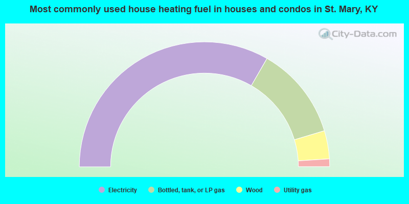
- 66.7%Electricity
- 24.1%Bottled, tank, or LP gas
- 7.3%Wood
- 2.0%Utility gas
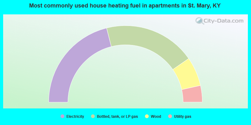
- 42.1%Electricity
- 38.6%Bottled, tank, or LP gas
- 12.3%Wood
- 7.0%Utility gas
St. Mary compared to Kentucky state average:
- Unemployed percentage significantly below state average.
- Black race population percentage above state average.
- Hispanic race population percentage significantly below state average.
- Median age significantly below state average.
- Foreign-born population percentage significantly below state average.
- Renting percentage significantly below state average.
- Length of stay since moving in significantly above state average.
- Number of rooms per house significantly below state average.
- House age significantly below state average.
- Institutionalized population percentage significantly above state average.
- Percentage of population with a bachelor's degree or higher significantly below state average.
St. Mary on our top lists:
- #80 on the list of "Top 101 cities with the largest percentage of people in state prisons (population 1,000+)"