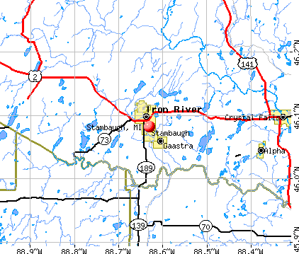
Stambaugh, Michigan

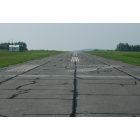
Stambaugh: Stambaugh Airport Runway 35
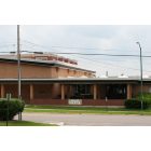
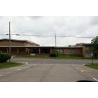
Stambaugh: Stambaugh Elementary School
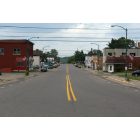
Stambaugh: Main drag in downtown Stambaugh
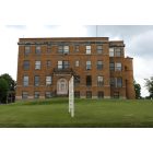
Stambaugh: Stambaugh Health Bldg
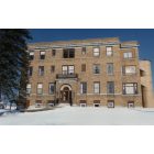
Stambaugh: Stambaugh Hospital

Stambaugh: Stambaugh Downtown
Stambaugh: Stambaugh Elementary School
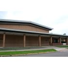
Stambaugh: Stambaugh Elementary School
Stambaugh: Stambaugh Airport Runway 17
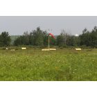
Stambaugh: Stambaugh Airport
- add
your
Submit your own pictures of this city and show them to the world
- OSM Map
- General Map
- Google Map
- MSN Map
| Males: 513 | |
| Females: 618 |
| Median resident age: | 43.2 years |
| Michigan median age: | 35.5 years |
Zip codes: 49964.
| Stambaugh: | $42,288 |
| MI: | $66,986 |
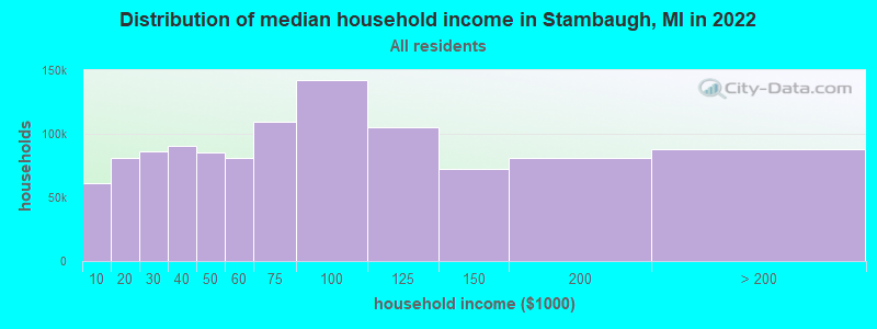
Estimated per capita income in 2022: $30,976 (it was $15,890 in 2000)
Stambaugh city income, earnings, and wages data
Estimated median house or condo value in 2022: $79,286 (it was $37,900 in 2000)
| Stambaugh: | $79,286 |
| MI: | $224,400 |
Mean prices in 2022: all housing units: $169,454; detached houses: $173,042; townhouses or other attached units: $202,626; in 2-unit structures: $72,981; in 5-or-more-unit structures: $198,061; mobile homes: $68,713
Detailed information about poverty and poor residents in Stambaugh, MI


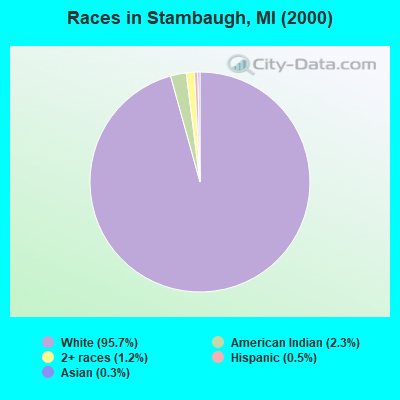
- 1,18995.7%White alone
- 292.3%American Indian alone
- 151.2%Two or more races
- 60.5%Hispanic
- 40.3%Asian alone
Races in Stambaugh detailed stats: ancestries, foreign born residents, place of birth
 Recent articles from our blog. Our writers, many of them Ph.D. graduates or candidates, create easy-to-read articles on a wide variety of topics.

 | Western UP town questions... (5 replies) |
| Iron River Rest (0 replies) |
Latest news from Stambaugh, MI collected exclusively by city-data.com from local newspapers, TV, and radio stations
Ancestries: German (21.3%), Swedish (13.8%), English (12.8%), Italian (11.1%), Polish (11.1%), French (10.4%).
Current Local Time: CST time zone
Elevation: 1539 feet
Land area: 1.64 square miles.
Population density: 688 people per square mile (low).

11 residents are foreign born
| This city: | 0.9% |
| Michigan: | 5.3% |
| Stambaugh city: | 1.7% ($660) |
| Michigan: | 1.3% ($1,461) |
Nearest city with pop. 50,000+: Green Bay, WI  (112.5 miles , pop. 102,313).
Nearest city with pop. 200,000+: Madison, WI (211.4 miles , pop. 208,054).
Nearest city with pop. 1,000,000+: Chicago, IL (297.1 miles , pop. 2,896,016).
Nearest cities:
), ), ), )Latitude: 46.08 N, Longitude: 88.63 W
Area code commonly used in this area: 906

| Here: | 5.7% |
| Michigan: | 3.5% |
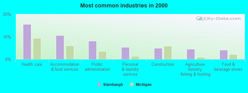
- Health care (15.6%)
- Accommodation & food services (10.6%)
- Public administration (8.1%)
- Personal & laundry services (5.4%)
- Construction (5.0%)
- Agriculture, forestry, fishing & hunting (4.6%)
- Food & beverage stores (4.1%)
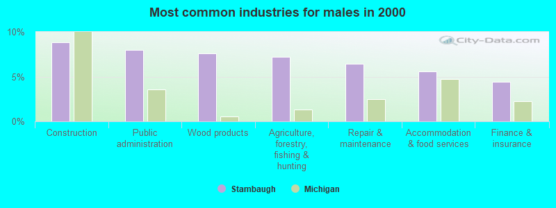
- Construction (8.8%)
- Public administration (8.0%)
- Wood products (7.6%)
- Agriculture, forestry, fishing & hunting (7.2%)
- Repair & maintenance (6.4%)
- Accommodation & food services (5.6%)
- Finance & insurance (4.4%)
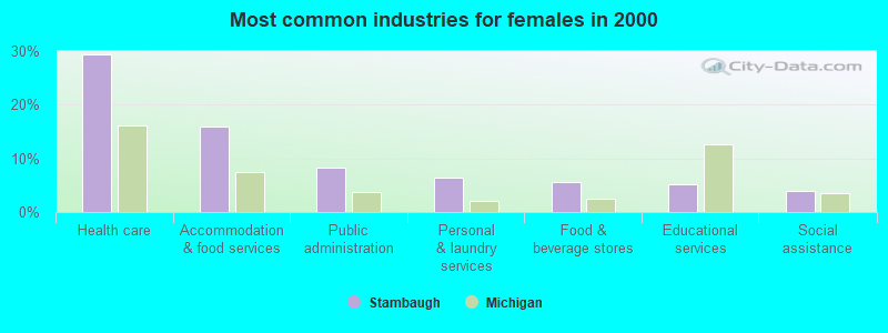
- Health care (29.3%)
- Accommodation & food services (15.9%)
- Public administration (8.2%)
- Personal & laundry services (6.5%)
- Food & beverage stores (5.6%)
- Educational services (5.2%)
- Social assistance (3.9%)
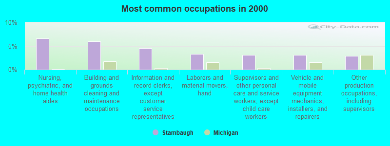
- Nursing, psychiatric, and home health aides (6.6%)
- Building and grounds cleaning and maintenance occupations (6.0%)
- Information and record clerks, except customer service representatives (4.6%)
- Laborers and material movers, hand (3.3%)
- Supervisors and other personal care and service workers, except child care workers (3.1%)
- Vehicle and mobile equipment mechanics, installers, and repairers (3.1%)
- Other production occupations, including supervisors (2.9%)

- Laborers and material movers, hand (6.4%)
- Vehicle and mobile equipment mechanics, installers, and repairers (6.0%)
- Fishing, hunting, and forestry occupations (5.6%)
- Driver/sales workers and truck drivers (5.2%)
- Building and grounds cleaning and maintenance occupations (4.8%)
- Other production occupations, including supervisors (4.8%)
- Electrical equipment mechanics and other installation, maintenance, and repair workers, including supervisors (4.0%)
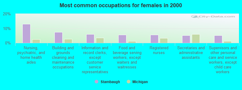
- Nursing, psychiatric, and home health aides (12.9%)
- Building and grounds cleaning and maintenance occupations (7.3%)
- Information and record clerks, except customer service representatives (6.0%)
- Food and beverage serving workers, except waiters and waitresses (5.6%)
- Registered nurses (5.6%)
- Secretaries and administrative assistants (5.2%)
- Supervisors and other personal care and service workers, except child care workers (5.2%)
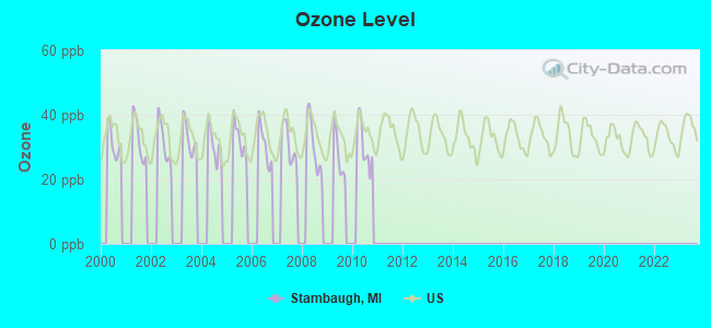
Average climate in Stambaugh, Michigan
Based on data reported by over 4,000 weather stations


|
|


Tornado activity:
Stambaugh-area historical tornado activity is significantly below Michigan state average. It is 69% smaller than the overall U.S. average.
On 6/25/1950, a category F4 (max. wind speeds 207-260 mph) tornado 44.1 miles away from the Stambaugh city center killed 2 people and injured 12 people and caused between $50,000 and $500,000 in damages.
On 7/4/1986, a category F3 (max. wind speeds 158-206 mph) tornado 38.9 miles away from the city center injured 12 people and caused between $50,000 and $500,000 in damages.
Earthquake activity:
Stambaugh-area historical earthquake activity is above Michigan state average. It is 82% smaller than the overall U.S. average.On 7/9/1975 at 14:54:15, a magnitude 4.6 (4.6 MB, Class: Light, Intensity: IV - V) earthquake occurred 357.9 miles away from Stambaugh center
On 5/2/2015 at 16:23:07, a magnitude 4.2 (4.2 MW, Depth: 2.8 mi) earthquake occurred 309.8 miles away from Stambaugh center
On 6/28/2004 at 06:10:52, a magnitude 4.2 (4.2 MW, Depth: 6.2 mi) earthquake occurred 320.0 miles away from the city center
On 2/10/2010 at 09:59:35, a magnitude 3.8 (3.8 MW, Depth: 6.2 mi, Class: Light, Intensity: II - III) earthquake occurred 284.5 miles away from Stambaugh center
On 3/2/2017 at 16:53:31, a magnitude 3.2 (3.2 ML) earthquake occurred 190.3 miles away from the city center
On 1/31/1986 at 16:46:43, a magnitude 5.0 (5.0 MB, Class: Moderate, Intensity: VI - VII) earthquake occurred 484.3 miles away from the city center
Magnitude types: body-wave magnitude (MB), local magnitude (ML), moment magnitude (MW)
Natural disasters:
The number of natural disasters in Iron County (5) is a lot smaller than the US average (15).Major Disasters (Presidential) Declared: 1
Emergencies Declared: 3
Causes of natural disasters: Blizzard: 1, Drought: 1, Flood: 1, Hurricane: 1, Snowstorm: 1, Other: 1 (Note: some incidents may be assigned to more than one category).

Hospitals and medical centers near Stambaugh:
- DICKINSON IRON DIST HELTH DEPT (Hospital, about 1 miles away; IRON RIVER, MI)
- IRON RIVER CARE CENTER (Nursing Home, about 1 miles away; IRON RIVER, MI)
- UNITED HOME CARE (Home Health Center, about 2 miles away; IRON RIVER, MI)
- NORTHSTAR HEALTH SYSTEM Critical Access Hospitals (about 2 miles away; IRON RIVER, MI)
- CRYSTAL MANOR NURSING HOME (Nursing Home, about 15 miles away; CRYSTAL FALLS, MI)
- CRYSTAL FALLS COMMUNITY HOSPITAL (Hospital, about 15 miles away; CRYSTAL FALLS, MI)
Colleges/universities with over 2000 students nearest to Stambaugh:
- Northern Michigan University (about 68 miles; Marquette, MI; Full-time enrollment: 8,258)
- Michigan Technological University (about 72 miles; Houghton, MI; FT enrollment: 6,078)
- Northcentral Technical College (about 91 miles; Wausau, WI; FT enrollment: 3,356)
- Northeast Wisconsin Technical College (about 111 miles; Green Bay, WI; FT enrollment: 6,069)
- University of Wisconsin-Green Bay (about 113 miles; Green Bay, WI; FT enrollment: 5,415)
- Saint Norbert College (about 117 miles; De Pere, WI; FT enrollment: 2,324)
- University of Wisconsin-Stevens Point (about 117 miles; Stevens Point, WI; FT enrollment: 9,089)
User-submitted facts and corrections:
- Stambaugh is now suposed to be Iron River Hights, but we all like to call it Stambaugh still (even though Stambaugh is only the lot on wich the post office sits on). added by Kitt
Points of interest:
Notable location: Iron River Country Club (A). Display/hide its location on the map
Churches in Stambaugh include: Trinity Lutheran Church (A), First Baptist Church (B), Grace Covenant Church (C), Saint Peters Lutheran Church (D). Display/hide their locations on the map
Cemetery: Stambaugh Cemetery (1). Display/hide its location on the map
Parks in Stambaugh include: Hoover Park (1), Nelson Field (2). Display/hide their locations on the map
| This city: | 2.1 people |
| Michigan: | 2.6 people |
| This city: | 57.6% |
| Whole state: | 68.5% |
| This city: | 6.1% |
| Whole state: | 5.3% |
Likely homosexual households (counted as self-reported same-sex unmarried-partner households)
- Lesbian couples: 0.2% of all households
- Gay men: 0.0% of all households
| This city: | 13.5% |
| Whole state: | 10.5% |
| This city: | 4.6% |
| Whole state: | 4.8% |
For population 15 years and over in Stambaugh:
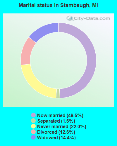
- Never married: 22.0%
- Now married: 49.5%
- Separated: 1.6%
- Widowed: 14.4%
- Divorced: 12.6%
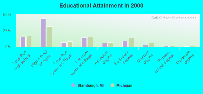
For population 25 years and over in Stambaugh:
- High school or higher: 84.3%
- Bachelor's degree or higher: 13.4%
- Graduate or professional degree: 4.4%
- Unemployed: 7.7%
- Mean travel time to work (commute): 19.3 minutes
| Here: | 8.7 |
| Michigan average: | 11.3 |
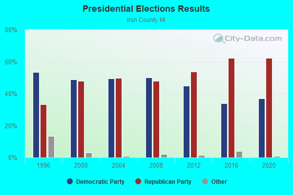
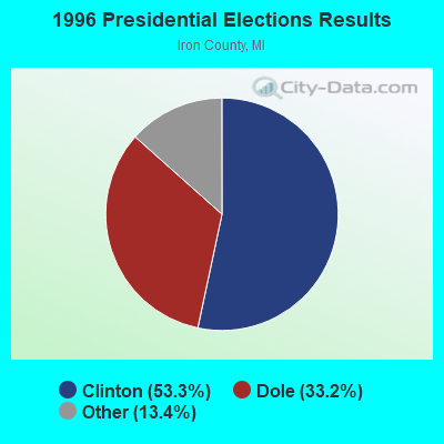
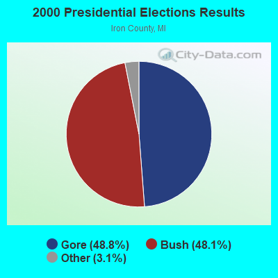
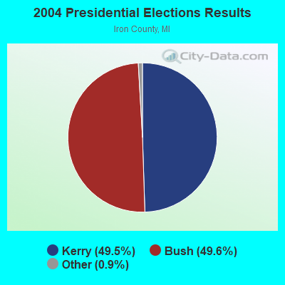

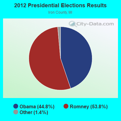
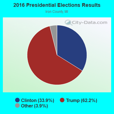
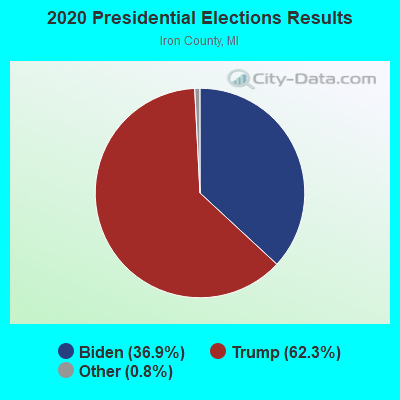
Graphs represent county-level data. Detailed 2008 Election Results
Religion statistics for Stambaugh, MI (based on Iron County data)
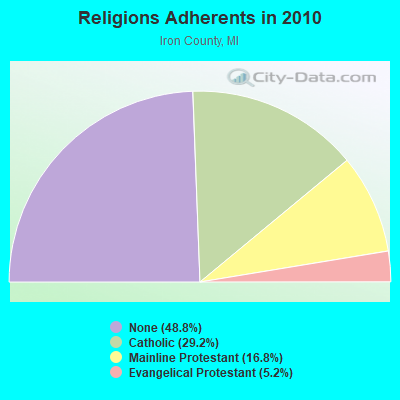
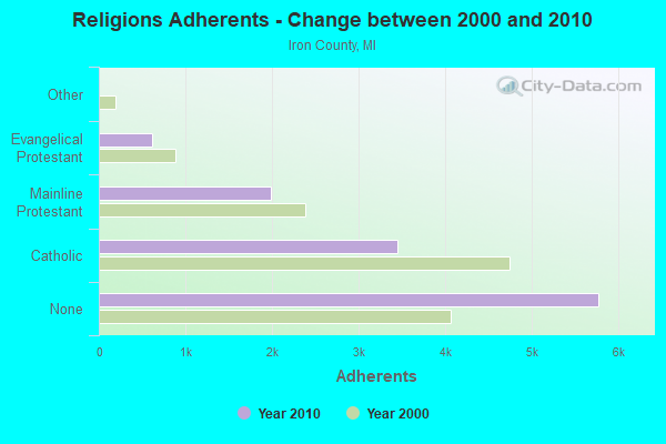
| Religion | Adherents | Congregations |
|---|---|---|
| Catholic | 3,451 | 3 |
| Mainline Protestant | 1,981 | 10 |
| Evangelical Protestant | 612 | 12 |
| Other | 1 | 1 |
| None | 5,772 | - |
Food Environment Statistics:
| Iron County: | 3.30 / 10,000 pop. |
| Michigan: | 2.34 / 10,000 pop. |
| Here: | 0.83 / 10,000 pop. |
| Michigan: | 1.52 / 10,000 pop. |
| Iron County: | 11.57 / 10,000 pop. |
| Michigan: | 2.99 / 10,000 pop. |
| This county: | 14.87 / 10,000 pop. |
| Michigan: | 6.80 / 10,000 pop. |
| Iron County: | 10.5% |
| State: | 9.7% |
| Iron County: | 28.5% |
| Michigan: | 29.7% |
| Iron County: | 15.6% |
| Michigan: | 13.4% |
Strongest AM radio stations in Stambaugh:
- WIKB (1230 AM; 1 kW; IRON RIVER, MI; Owner: NORTHLAND ADVERTISING, INC.)
- WSPT (1010 AM; 50 kW; STEVENS POINT, WI)
- WSAU (550 AM; 20 kW; WAUSAU, WI; Owner: WRIG, INC.)
- WEBC (560 AM; 50 kW; DULUTH, MN)
- WDBC (680 AM; 10 kW; ESCANABA, MI; Owner: KMB BROADCASTING, INC.)
- WNAM (1280 AM; 50 kW; NEENAH-MENASHA, WI; Owner: CUMULUS LICENSING CORP.)
- WTCM (580 AM; 35 kW; TRAVERSE CITY, MI; Owner: WTCM RADIO, INC.)
- WZAM (970 AM; 5 kW; ISHPEMING, MI)
- WTMJ (620 AM; 50 kW; MILWAUKEE, WI; Owner: JOURNAL BROADCAST CORPORATION)
- WLDR (1210 AM; daytime; 50 kW; KINGSLEY, MI; Owner: FORT BEND BROADCASTING COMPANY)
- WJMS (590 AM; 5 kW; IRONWOOD, MI; Owner: ROBERTS BROADCASTING, INC.)
- WHBY (1150 AM; 25 kW; KIMBERLY, WI; Owner: WOODWARD COMMUNICATIONS, INC.)
- WERL (950 AM; 1 kW; EAGLE RIVER, WI)
Strongest FM radio stations in Stambaugh:
- W237AW (95.3 FM; IRON RIVER, MI; Owner: WRVM, INC.)
- WIKB-FM (99.1 FM; IRON RIVER, MI; Owner: NORTHLAND ADVERTISING, INC.)
- WNMU-FM (90.1 FM; MARQUETTE, MI; Owner: NORTHERN MICHIGAN UNIVERSITY)
- WOBE (100.7 FM; CRYSTAL FALLS, MI; Owner: RESULTS BROADCASTING OF IRON MOUNTAIN, INC.)
- WHTO (106.7 FM; IRON MOUNTAIN, MI; Owner: TODD STUART NOORDYK)
- WJNR-FM (101.5 FM; IRON MOUNTAIN, MI; Owner: RESULTS BROADCASTING OF IRON MOUNTAIN, INC.)
- WVCM (91.5 FM; IRON MOUNTAIN, MI; Owner: VCY AMERICA INC.)
- WIMK (93.1 FM; IRON MOUNTAIN, MI; Owner: NORTHERN STAR BROADCASTING, L.L.C.)
- W244AW (96.7 FM; IRON MOUNTAIN, MI; Owner: FAMILY ED BC CORP OF DOOR CNTY WI)
TV broadcast stations around Stambaugh:
- WYOW (Channel 34; EAGLE RIVER, WI; Owner: WAOW-WYOW TELEVISION, INC.)
- WJFW-TV (Channel 12; RHINELANDER, WI; Owner: NORTHLAND TELEVISION, INC.)
- KTTM (Channel 12; HURON, SD; Owner: INDEPENDENT COMMUNICATIONS, INC.)
- W54AR (Channel 54; FENCE, WI; Owner: STATE OF WISCONSIN - EDUCATIONAL COMMUNICATIONS BOARD)
- WUPT-CA (Channel 25; CRYSTAL FALLS, MI; Owner: WESTERN UPPER PENINSULA TELEVISION, INC.)
Stambaugh fatal accident list:
Jun 7, 2016 09:11 PM, Sr-189, Lat: 46.022453, Lon: -88.634728, Vehicles: 1, Persons: 2, Fatalities: 2, Drunk persons involved: 1
Oct 15, 2010 09:15 PM, Sr-189, Lat: 46.011850, Lon: -88.637117, Vehicles: 1, Persons: 1, Fatalities: 1, Drunk persons involved: 1
Nov 24, 2006 07:54 AM, County Rd 424, Lat: 46.058370, Lon: -88.558280, Vehicles: 1, Persons: 1, Fatalities: 1
Dec 16, 1977 09:00 PM, Vehicles: 1, Persons: 2, Fatalities: 1
- National Bridge Inventory (NBI) Statistics
- 1Number of bridges
- 10ft / 3.1mTotal length
- 1,094Total average daily traffic
- 251Total average daily truck traffic
- 1,341Total future (year 2018) average daily traffic
FCC Registered Antenna Towers:
3- MARGARET V KLINGFORTH, Hwy 189 S (Lat: 46.073056 Lon: -88.641667), Type: 32.0, Overall height: 30 m, Registrant: Consolidated Papers, Inc., 8050 Wisco-nsin Rapids, Phone: (715) 422-3111
- MARGARET V KLINGFORTH, Hwy 189 S (Lat: 46.073056 Lon: -88.641667), Type: 32.0, Overall height: 30 m, Registrant: Consolidated Papers, Inc., 8050 Wisco-nsin Rapids, Phone: (715) 422-3111
- MARGARET C KLINGFORTH, Hwy 189 S (Lat: 46.073056 Lon: -88.641667), Type: 32.0, Overall height: 30 m, Registrant: Consolidated Papers, Inc., 8050 Wisco-nsin Rapids, Phone: (715) 422-3111
FCC Registered Microwave Towers:
1- STATION, 923 Seldon Rd (Lat: 46.075778 Lon: -88.643444), Overall height: 19.8 m, Call Sign: WNEW761,
Assigned Frequencies: 18955.0 MHz, Grant Date: 03/31/2009, Expiration Date: 05/26/2019, Cancellation Date: 09/17/2009, Phone: (414) 221-2226
FCC Registered Amateur Radio Licenses:
8 (See the full list of FCC Registered Amateur Radio Licenses in Stambaugh)| Most common first names in Stambaugh, MI among deceased individuals | ||
| Name | Count | Lived (average) |
|---|---|---|
| John | 25 | 75.0 years |
| William | 18 | 76.8 years |
| Frank | 18 | 82.2 years |
| George | 12 | 73.3 years |
| Robert | 12 | 69.2 years |
| Clarence | 10 | 70.8 years |
| Edward | 10 | 73.0 years |
| Mary | 8 | 85.5 years |
| Charles | 8 | 70.0 years |
| Joseph | 8 | 70.3 years |
| Most common last names in Stambaugh, MI among deceased individuals | ||
| Last name | Count | Lived (average) |
|---|---|---|
| Peterson | 16 | 78.4 years |
| Anderson | 14 | 77.1 years |
| Johnson | 11 | 78.0 years |
| Carlson | 10 | 77.1 years |
| Holmes | 9 | 75.7 years |
| Williams | 8 | 66.0 years |
| Baumgartner | 7 | 80.3 years |
| Erickson | 7 | 82.3 years |
| Vassar | 5 | 80.4 years |
| Youngren | 5 | 78.8 years |
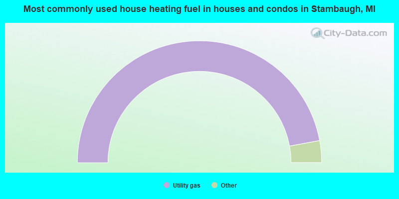
- 94.2%Utility gas
- 2.3%Electricity
- 1.5%Fuel oil, kerosene, etc.
- 1.5%Wood
- 0.5%Bottled, tank, or LP gas
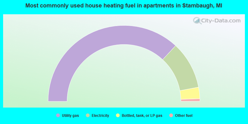
- 73.8%Utility gas
- 20.2%Electricity
- 4.9%Bottled, tank, or LP gas
- 1.1%Other fuel
Stambaugh compared to Michigan state average:
- Median household income below state average.
- Median house value significantly below state average.
- Unemployed percentage below state average.
- Black race population percentage significantly below state average.
- Hispanic race population percentage significantly below state average.
- Foreign-born population percentage significantly below state average.
- Renting percentage significantly below state average.
- Length of stay since moving in significantly above state average.
- Number of rooms per house significantly below state average.
- House age significantly below state average.
- Number of college students below state average.
- Percentage of population with a bachelor's degree or higher below state average.