Estimated median house or condo value in 2022: $397,320 (it was $116,600 in 2000)
Standish:
$397,320
ME:
$290,600
Mean prices in 2022:all housing units: $514,200; detached houses: $533,395; townhouses or other attached units: $572,947; in 2-unit structures: $538,406; in 3-to-4-unit structures: $462,507; in 5-or-more-unit structures: $450,834; mobile homes: $93,551March 2022 cost of living index in Standish: 94.7 (less than average, U.S. average is 100)
According to our research of Maine and other state lists, there were 9 registered sex offenders living in Standish, Maine as of April 27, 2024. The ratio of all residents to sex offenders in Standish is 1,097 to 1. The ratio of registered sex offenders to all residents in this city is lower than the state average.
Recent articles from our blog. Our writers, many of them Ph.D. graduates or candidates, create easy-to-read articles on a wide variety of topics.
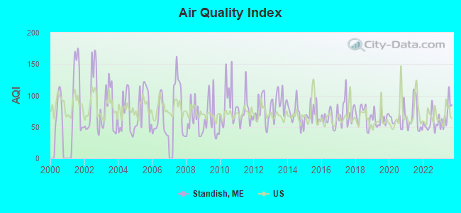
Air Quality Index (AQI) level in 2023 was 70.4. This is about average.
City:
70.4
U.S.:
72.6
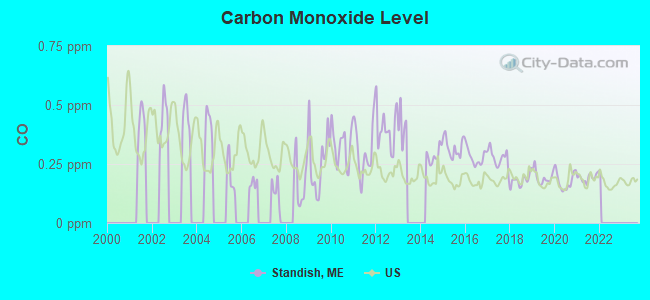
Carbon Monoxide (CO) [ppm] level in 2021 was 0.192. This is better than average.Closest monitor was 16.3 miles away from the city center.
City:
0.192
U.S.:
0.251
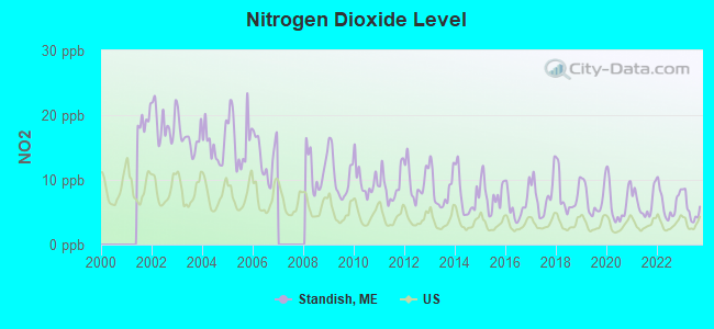
Nitrogen Dioxide (NO2) [ppb] level in 2023 was 5.47. This is about average.Closest monitor was 16.3 miles away from the city center.
City:
5.47
U.S.:
5.11
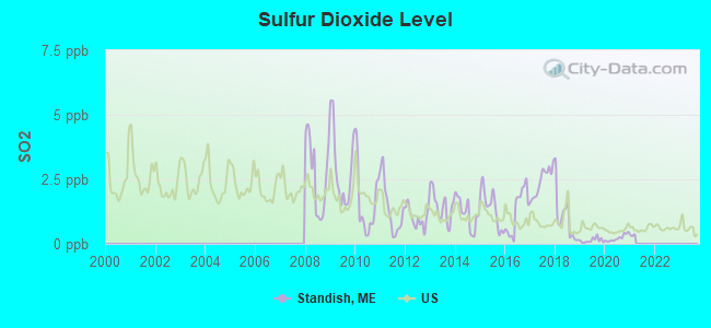
Sulfur Dioxide (SO2) [ppb] level in 2020 was 0.222. This is significantly better than average.Closest monitor was 11.5 miles away from the city center.
City:
0.222
U.S.:
1.515
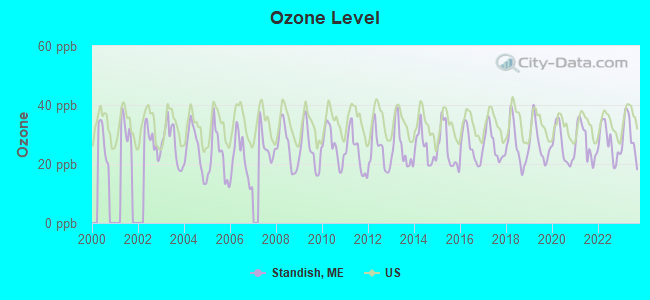
Ozone [ppb] level in 2023 was 29.5. This is about average.Closest monitor was 7.9 miles away from the city center.
City:
29.5
U.S.:
33.3
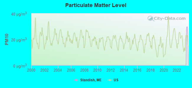
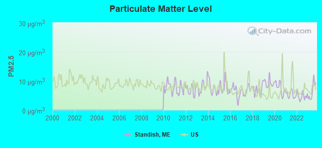
Particulate Matter (PM2.5) [µg/m3] level in 2023 was 6.49. This is better than average.Closest monitor was 11.4 miles away from the city center.
City:
6.49
U.S.:
8.11
Tornado activity:
Standish-area historical tornado activity is above Maine state average. It is 75% smaller than the overall U.S. average.
On 10/10/1966, a category F2 (max. wind speeds 113-157 mph) tornado 25.4 miles away from the Standish town center causedbetween $5000 and $50,000 in damages.
On 7/18/1963, a category F2 tornado 33.7 miles away from the town center causedbetween $5000 and $50,000 in damages.
Earthquake activity:
Standish-area historical earthquake activity is significantly above Maine state average. It is 74% smaller than the overall U.S. average.
On 10/16/2012 at 23:12:25, a magnitude 4.7 (4.7 ML, Depth: 10.0 mi, Class: Light, Intensity: IV - V) earthquake occurred 12.3 miles away from the city center On 4/20/2002 at 10:50:47, a magnitude 5.3 (5.3 ML, Depth: 3.0 mi, Class: Moderate, Intensity: VI - VII) earthquake occurred 163.9 miles away from Standish center On 1/19/1982 at 00:14:42, a magnitude 4.7 (4.5 MB, 4.7 MD, 4.5 LG) earthquake occurred 54.9 miles away from Standish center On 4/20/2002 at 10:50:47, a magnitude 5.2 (5.2 MB, 4.2 MS, 5.2 MW, 5.0 MW) earthquake occurred 164.4 miles away from the city center On 10/7/1983 at 10:18:46, a magnitude 5.3 (5.1 MB, 5.3 LG, 5.1 ML) earthquake occurred 188.9 miles away from the city center On 8/21/1996 at 07:54:14, a magnitude 3.8 (3.8 LG, 3.6 LG, Depth: 6.2 mi, Class: Light, Intensity: II - III) earthquake occurred 48.9 miles away from Standish center Magnitude types: regional Lg-wave magnitude (LG), body-wave magnitude (MB), duration magnitude (MD), local magnitude (ML), surface-wave magnitude (MS), moment magnitude (MW)
Natural disasters:
The number of natural disasters in Cumberland County (33) is a lot greater than the US average (15). Major Disasters (Presidential) Declared: 22 Emergencies Declared: 10
Causes of natural disasters: Floods: 19, Storms: 13, Snows: 7, Winter Storms: 6, Heavy Rains: 3, Hurricanes: 3, Winds: 3, Blizzard: 1, Ice Storm: 1, Mudslide: 1, Snowfall: 1, Snowstorm: 1, Tornado: 1, Other: 2 (Note: some incidents may be assigned to more than one category).
Hospitals and medical centers near Standish:
GORHAM HEALTH CENTER (Nursing Home, about 9 miles away; GORHAM, ME)
GORHAM HOUSE (Nursing Home, about 9 miles away; GORHAM, ME)
WESTBROOK COMMUNITY HOSPITAL (Hospital, about 12 miles away; WESTBROOK, ME)
SPRINGBROOK CENTER (Nursing Home, about 13 miles away; WESTBROOK, ME)
CASCO BAY DIALYSIS FACILITY (Dialysis Facility, about 13 miles away; WESTBROOK, ME)
BARRON CENTER (Nursing Home, about 14 miles away; PORTLAND, ME)
ALLEGIANCE HOSPICE AND PALLATIVE CARE OF MAINE (Hospital, about 15 miles away; SO PORTLAND, ME)
Saint Joseph's College of Maine (Full-time enrollment: 2,010; Location: 278 Whites Bridge Rd; Private, not-for-profit; Website: www.sjcme.edu; Offers Master's degree)
Other colleges/universities with over 2000 students near Standish:
University of Southern Maine (about 16 miles; Portland, ME; Full-time enrollment: 6,647)
Southern Maine Community College (about 19 miles; South Portland, ME; FT enrollment: 4,666)
University of New England (about 23 miles; Biddeford, ME; FT enrollment: 4,539)
University of New Hampshire-Main Campus (about 48 miles; Durham, NH; FT enrollment: 15,243)
University of Maine at Augusta (about 56 miles; Augusta, ME; FT enrollment: 3,204)
Plymouth State University (about 57 miles; Plymouth, NH; FT enrollment: 4,838)
NHTI-Concord's Community College (about 62 miles; Concord, NH; FT enrollment: 2,865)
Notable locations in Standish: Daniel Marrett House Museum (A), Standish Fire and Emergency Medical Services District 1 and 2 (B). Display/hide their locations on the map
Birthplace of: Albion P. Howe - Union Army general, Ben Earle - College basketball player (Furman Paladins).
Cumberland County has a predicted average indoor radon screening level greater than 4 pCi/L (pico curies per liter) - Highest Potential
Drinking water stations with addresses in Standish and their reported violations in the past:
PINE TREE MOBILE ESTATES (Population served: 475, Groundwater):
Past monitoring violations:
Follow-up Or Routine LCR Tap M/R - In JUL-01-1998, Contaminant: Lead and Copper Rule. Follow-up actions: St Formal NOV issued (JAN-30-1999)
Follow-up Or Routine LCR Tap M/R - In JAN-01-1998, Contaminant: Lead and Copper Rule. Follow-up actions: St Formal NOV issued (JUL-30-1998)
Follow-up Or Routine LCR Tap M/R - In JUN-22-1995, Contaminant: Lead and Copper Rule
One routine major monitoring violation
FAMILY AND FRIENDS CAMPGROUND (Population served: 175, Groundwater):
Past health violations:
MCL, Acute (TCR) - In AUG-2012, Contaminant: Coliform. Follow-up actions: St Formal NOV issued (AUG-27-2012), St Compliance Meeting conducted (AUG-27-2012), St Public Notif requested (AUG-27-2012), St Tech Assistance Visit (AUG-27-2012), St Boil Water Order (AUG-27-2012), St Public Notif received (OCT-19-2012)
MCL, Monthly (TCR) - In AUG-2008, Contaminant: Coliform. Follow-up actions: St Public Notif requested (AUG-13-2008), St Formal NOV issued (AUG-13-2008), St Public Notif received (AUG-20-2008), St Compliance achieved (JUN-14-2011)
MCL, Monthly (TCR) - Between JUL-2008 and SEP-2008, Contaminant: Coliform. Follow-up actions: St Public Notif received (AUG-11-2008), St Public Notif requested (AUG-13-2008), St Formal NOV issued (AUG-13-2008), St Compliance achieved (JUN-14-2011)
CHRISTIAN FELLOWSHIP/RENEWAL (Population served: 100, Groundwater):
Past monitoring violations:
Monitoring, Repeat Major (TCR) - In AUG-2006, Contaminant: Coliform (TCR). Follow-up actions: St Public Notif requested (SEP-07-2006), St Violation/Reminder Notice (SEP-07-2006), St Compliance achieved (JAN-29-2007), St Intentional no-action (SEP-15-2011)
4 routine major monitoring violations
3 regular monitoring violations
STANDISH BAPTIST CHURCH (Population served: 73, Groundwater):
Past health violations:
MCL, Average - Between OCT-2012 and DEC-2012, Contaminant: Arsenic. Follow-up actions: St Public Notif received (FEB-12-2013), St Public Notif requested (MAR-01-2013), St Formal NOV issued (MAR-01-2013), St Compliance achieved (MAY-21-2013)
MCL, Average - Between JUL-2012 and SEP-2012, Contaminant: Arsenic. Follow-up actions: St Public Notif requested (NOV-01-2012), St Formal NOV issued (NOV-01-2012), St Public Notif received (FEB-12-2013), St Compliance achieved (MAY-21-2013)
MCL, Average - Between APR-2012 and JUN-2012, Contaminant: Arsenic. Follow-up actions: St BCA signed (APR-21-2011), St Public Notif requested (JUL-27-2012), St Formal NOV issued (JUL-27-2012), St Public Notif received (FEB-12-2013), St Compliance achieved (MAY-21-2013)
MCL, Monthly (TCR) - In NOV-2011, Contaminant: Coliform. Follow-up actions: St BCA signed (APR-21-2011), St Public Notif requested (DEC-19-2011), St Formal NOV issued (DEC-19-2011), St Public Notif received (JAN-27-2012), St Compliance achieved (NOV-06-2012)
MCL, Monthly (TCR) - Between JUL-2008 and SEP-2008, Contaminant: Coliform. Follow-up actions: St Public Notif requested (AUG-29-2008), St Formal NOV issued (AUG-29-2008), St Compliance achieved (JUN-22-2009), St BCA signed (APR-21-2011), St Case appealed (JUN-01-2011), St Intentional no-action (OCT-04-2011)
OCCT/SOWT Study/Recommendation - In OCT-14-2005, Contaminant: Lead and Copper Rule. Follow-up actions: St Violation/Reminder Notice (MAR-14-2006), St AO (w/o penalty) issued (JUL-19-2007), St Compliance achieved (SEP-24-2007), St BCA signed (APR-21-2011), St Case appealed (JUN-01-2011)
Public Education - In JUN-25-2005, Contaminant: Lead and Copper Rule. Follow-up actions: St Violation/Reminder Notice (MAR-14-2006), St AO (w/o penalty) issued (JUL-19-2007), St Public Notif received (AUG-30-2007), St Compliance achieved (SEP-24-2007), St BCA signed (APR-21-2011), St Case appealed (JUN-01-2011)
Past monitoring violations:
Follow-up Or Routine LCR Tap M/R - In JUL-01-2012, Contaminant: Lead and Copper Rule. Follow-up actions: St BCA signed (APR-21-2011), St Public Notif requested (AUG-07-2012), St Formal NOV issued (AUG-07-2012), St Compliance achieved (DEC-02-2012), St Public Notif received (OCT-21-2013)
Follow-up Or Routine LCR Tap M/R - In JUL-01-2011, Contaminant: Lead and Copper Rule. Follow-up actions: St BCA signed (APR-21-2011), St Public Notif requested (SEP-06-2011), St Formal NOV issued (SEP-06-2011), St Compliance achieved (NOV-30-2011)
Initial, Follow-up, or Routine Source Water M/R - In JUL-01-2011, Contaminant: Lead and Copper Rule. Follow-up actions: St BCA signed (APR-21-2011), St Public Notif requested (SEP-06-2011), St Formal NOV issued (SEP-06-2011)
Water Quality Parameter M/R - Between APR-2011 and JUN-2011, Contaminant: Lead and Copper Rule. Follow-up actions: St BCA signed (APR-21-2011), St Public Notif requested (AUG-22-2011), St Formal NOV issued (AUG-22-2011), St Compliance achieved (JAN-07-2013)
Water Quality Parameter M/R - Between JAN-2011 and MAR-2011, Contaminant: Lead and Copper Rule. Follow-up actions: St Formal NOV issued (APR-05-2011), St Public Notif requested (APR-05-2011), St AO (w/o penalty) issued (APR-08-2011), St BCA signed (APR-21-2011), St Admin Penalty assessed (MAY-04-2011), St Case appealed (JUN-01-2011), St Compliance achieved (OCT-12-2011)
12 routine major monitoring violations
40 regular monitoring violations
11 other older monitoring violations
LITTLE DUCKLINGS DAYCARE (Population served: 49, Groundwater):
Past monitoring violations:
Monitoring, Source Water (GWR) - In JUN-2014, Contaminant: E. COLI
Monitoring, Repeat Major (TCR) - Between APR-2014 and JUN-2014, Contaminant: Coliform (TCR)
3 routine major monitoring violations
2 regular monitoring violations
Drinking water stations with addresses in Standish that have no violations reported:
SEBAGO LAKE FAMILY CAMPGROUND (Population served: 253,Primary Water Source Type: Groundwater)
NORTHEASTERN ESTATES (Address: 102 NORTHEAST ROAD , Population served: 40,Primary Water Source Type: Groundwater)
Average household size:
This town:
2.6 people
Maine:
2.3 people
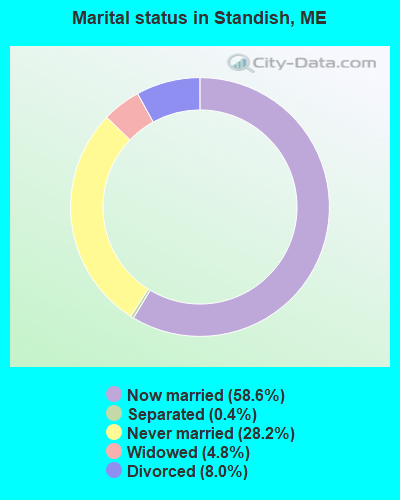
Percentage of family households:
This town:
73.1%
Whole state:
62.9%
Percentage of households with unmarried partners:
This town:
9.1%
Whole state:
9.4%
Likely homosexual households (counted as self-reported same-sex unmarried-partner households)
Lesbian couples: 0.5% of all households
Gay men: 0.4% of all households
Residents with income below the poverty level in 2009:
This town:
3.6%
Whole state:
10.9%
Residents with income below 50% of the poverty level in 2009:
This town:
1.5%
Whole state:
4.1%
People in group quarters in Standish in 2010:
705 people in college/university student housing
5 people in group homes intended for adults
4 people in other noninstitutional facilities
576 people in college dormitories (includes college quarters off campus) in 2000
5 people in nursing homes in 2000
Banks with branches in Standish (2011 data):
Gorham Savings Bank: Standish Branch at Colonial Market Place, Route 25, branch established on 1979/09/06. Info updated 2008/07/29: Bank assets: $912.7 mil, Deposits: $640.1 mil, headquarters in Gorham, ME, positive income, Commercial Lending Specialization, 11 total offices, Holding Company: Gorham Bancorp, Mhc
Norway Savings Bank: Standish Branch at 88 Ossippee Trail East, branch established on 2007/06/11. Info updated 2006/11/03: Bank assets: $958.8 mil, Deposits: $711.3 mil, headquarters in Norway, ME, positive income, Commercial Lending Specialization, 20 total offices, Holding Company: Norway Bancorp, Mhc
TD Bank, National Association: Standish Shop N Save Branch at 111 Ossipee Trail, branch established on 1997/12/19. Info updated 2010/10/04: Bank assets: $188,912.6 mil, Deposits: $153,149.8 mil, headquarters in Wilmington, DE, positive income, 1314 total offices, Holding Company: Toronto-Dominion Bank, The
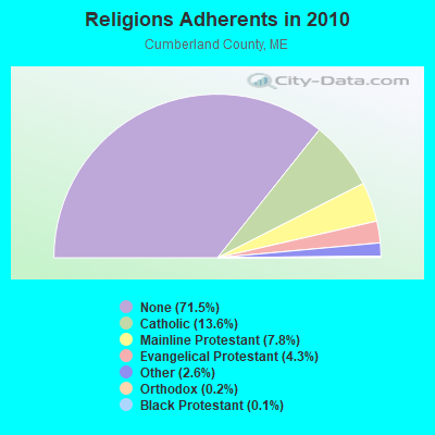
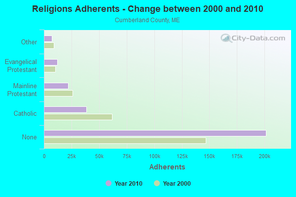
Religion statistics for Standish, ME (based on Cumberland County data)
Religion
Adherents
Congregations
Catholic
38,243
19
Mainline Protestant
22,030
96
Evangelical Protestant
12,007
85
Other
7,187
44
Orthodox
500
1
Black Protestant
285
2
None
201,422
-
Source: Clifford Grammich, Kirk Hadaway, Richard Houseal, Dale E.Jones, Alexei Krindatch, Richie Stanley and Richard H.Taylor. 2012. 2010 U.S.Religion Census: Religious Congregations & Membership Study. Association of Statisticians of American Religious Bodies. Jones, Dale E., et al. 2002. Congregations and Membership in the United States 2000. Nashville, TN: Glenmary Research Center. Graphs represent county-level data
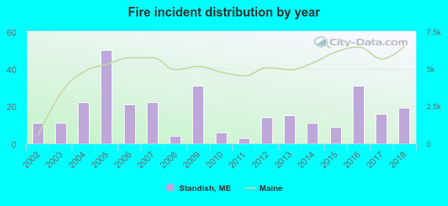
2002 - 2018 National Fire Incident Reporting System (NFIRS) incidents
Based on the data from the years 2002 - 2018 the average number of fires per year is 17. The highest number of fires - 50 took place in 2005, and the least - 3 in 2011. The data has a growing trend.
When looking into fire subcategories, the most incidents belonged to: Structure Fires (61.1%), and Outside Fires (18.2%).
Fire incident types reported to NFIRS in Standish, ME
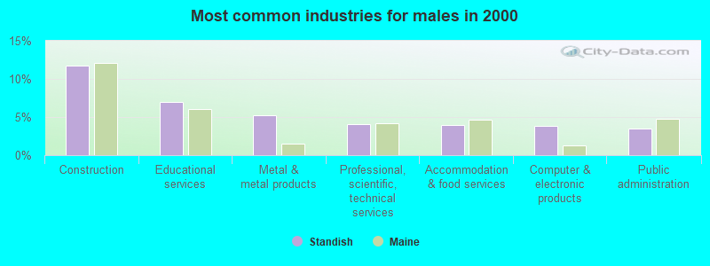
#8 on the list of "Top 101 cities with largest percentage of males in industries: petroleum and petroleum products merchant wholesalers (population 5,000+)"
#13 on the list of "Top 101 cities with largest percentage of males in industries: lumber and other construction materials merchant wholesalers (population 5,000+)"
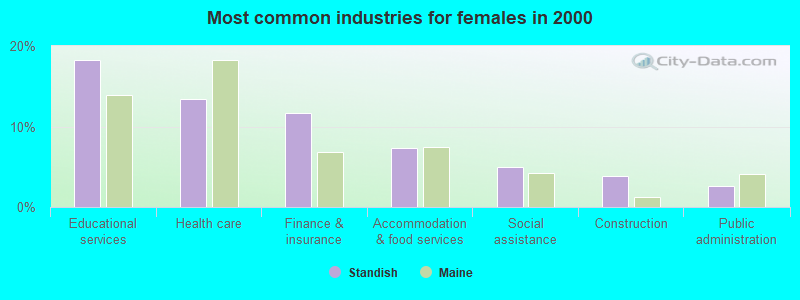
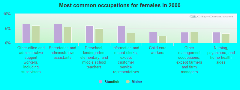
#15 on the list of "Top 101 cities with largest percentage of females in occupations: construction laborers (population 5,000+)"
#21 on the list of "Top 101 cities with largest percentage of males in industries: furniture and home furnishing merchant wholesalers (population 5,000+)"
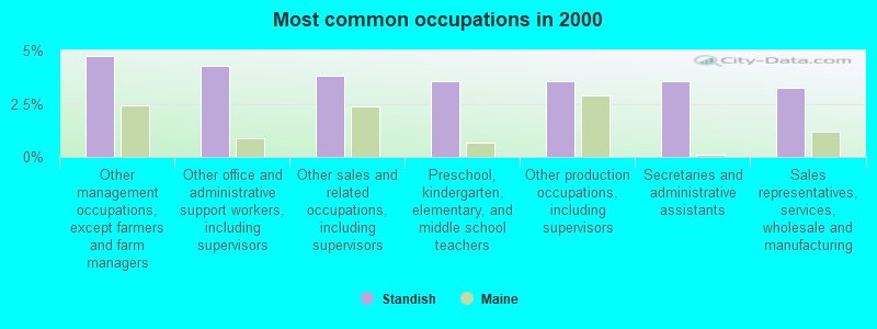
#27 on the list of "Top 101 cities with largest percentage of males in occupations: registered nurses (population 5,000+)"
#37 on the list of "Top 101 cities with the most residents born in Other Central America (population 500+)"
#44 on the list of "Top 101 cities with largest percentage of males in industries: gasoline stations (population 5,000+)"
#48 on the list of "Top 101 cities with largest percentage of males in occupations: assemblers and fabricators (population 5,000+)"
#48 on the list of "Top 101 cities with largest percentage of males in industries: machinery, equipment, and supplies merchant wholesalers (population 5,000+)"
#50 on the list of "Top 101 cities with largest percentage of males in industries: book stores and news dealers (population 5,000+)"
#50 on the list of "Top 101 cities with largest percentage of males in industries: farm product raw materials merchant wholesalers (population 5,000+)"
#52 on the list of "Top 101 cities with largest percentage of females in industries: wood products (population 5,000+)"
#59 on the list of "Top 101 cities with largest percentage of females in industries: paper and paper products merchant wholesalers (population 5,000+)"
#66 on the list of "Top 101 cities with largest percentage of females in occupations: other financial specialists (population 5,000+)"
#72 on the list of "Top 101 cities with largest percentage of males in occupations: architects, surveyors, and cartographers (population 5,000+)"
#77 on the list of "Top 101 cities with largest percentage of females in occupations: woodworkers (population 5,000+)"
#77 on the list of "Top 101 cities with largest percentage of males in industries: fuel dealers (population 5,000+)"
#101 on the list of "Top 101 cities with largest percentage of females in industries: fuel dealers (population 5,000+)"
#28 on the list of "Top 101 counties with the highest percentage of residents that exercised in the past month"
#30 on the list of "Top 101 counties with the best general health status score of residents (1-5), 3 years of data"
#40 on the list of "Top 101 counties with the highest percentage of residents that visited a dentist within the past year"
#43 on the list of "Top 101 counties with the highest Nitrogen Dioxide air pollution readings in 2012 (ppm)"
#49 on the list of "Top 101 counties with the lowest number of births per 1000 residents 2007-2013"


 Recent articles from our blog. Our writers, many of them Ph.D. graduates or candidates, create easy-to-read articles on a wide variety of topics.

 (16.2 miles


 Based on the data from the years 2002 - 2018 the average number of fires per year is 17. The highest number of fires - 50 took place in 2005, and the least - 3 in 2011. The data has a growing trend.
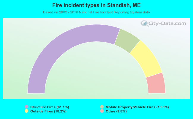 When looking into fire subcategories, the most incidents belonged to: Structure Fires (61.1%), and Outside Fires (18.2%).