Tilton, New Hampshire
Submit your own pictures of this town and show them to the world
- OSM Map
- General Map
- Google Map
- MSN Map
Population change since 2000: +2.6%
 |
| Males: 1,837 | |
| Females: 1,730 |
| Median resident age: | 45.2 years |
| New Hampshire median age: | 43.9 years |
Zip codes: 03276.
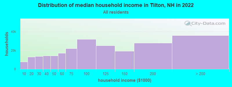
| Tilton: | $76,976 |
| NH: | $89,992 |
Estimated per capita income in 2022: $38,371 (it was $19,578 in 2000)
Tilton town income, earnings, and wages data
Estimated median house or condo value in 2022: $285,457 (it was $88,000 in 2000)
| Tilton: | $285,457 |
| NH: | $384,700 |
Mean prices in 2022: all housing units: $464,290; detached houses: $503,643; townhouses or other attached units: $657,649; in 2-unit structures: $254,871; in 3-to-4-unit structures: $448,739; in 5-or-more-unit structures: $289,404; mobile homes: $118,878
Detailed information about poverty and poor residents in Tilton, NH
Compare current foreclosures near Tilton, NH:
| Photo | Address | Area | Beds / Baths | Price | Details |
|---|---|---|---|---|---|

|
#1
Wethersfield Dr
Tilton, NH 03276
|
- sq. feet
|
- baths - beds |
show details | |

|
#2
Prospect St Apt 2
Tilton, NH 03276
|
- sq. feet
|
- baths - beds |
show details | |

|
#3
Scribner Rd # 78
Tilton, NH 03276
|
- sq. feet
|
- baths - beds |
show details | |

|
#4
Bay Hill Rd # 1
Tilton, NH 03276
|
- sq. feet
|
- baths - beds |
show details | |

|
#5
Summer St
Tilton, NH 03276
|
- sq. feet
|
- baths - beds |
show details | |

|
#6
Peverly Rd
Tilton, NH 03276
|
- sq. feet
|
- baths - beds |
show details | |

|
#7
School St
Tilton, NH 03276
|
- sq. feet
|
- baths - beds |
show details | |

|
#8
Hidden Ln
Tilton, NH 03276
|
- sq. feet
|
- baths - beds |
show details | |

|
#9
Fisherville Rd Unit 21
Concord, NH 03303
|
990 sq. feet
|
1 baths 2 beds |
show details | |

|
#10
Taylor Rd
Sanbornton, NH 03269
|
2,446 sq. feet
|
2 baths 4 beds |
show details |
| Photo | Address | Area | Beds / Baths | Price | Details |
|---|---|---|---|---|---|

|
#11
Pleasant St
Meredith, NH 03253
|
3,096 sq. feet
|
2 baths 4 beds |
show details | |

|
#12
Richmond Dr
Concord, NH 03303
|
1,776 sq. feet
|
2 baths 3 beds |
show details | |

|
#13
Abbott Rd
Concord, NH 03303
|
1,386 sq. feet
|
1 baths 2 beds |
show details | |

|
#14
Plymouth St
Meredith, NH 03253
|
2,232 sq. feet
|
2 baths 4 beds |
show details | |

|
#15
Duck Pond Ln
Warner, NH 03278
|
1,120 sq. feet
|
1 baths 3 beds |
show details | |

|
#16
Drake Rd
Sanbornton, NH 03269
|
2,376 sq. feet
|
2 baths 3 beds |
show details | |

|
#17
Strafford St
Laconia, NH 03246
|
1,820 sq. feet
|
2 baths 4 beds |
show details | |

|
#18
Province St
Laconia, NH 03246
|
818 sq. feet
|
1 baths 2 beds |
show details | |

|
#19
Adams St
Laconia, NH 03246
|
1,956 sq. feet
|
1 baths 3 beds |
show details | |

|
#20
Mechanic St
Laconia, NH 03246
|
2,537 sq. feet
|
2 baths 4 beds |
show details |
| Photo | Address | Area | Beds / Baths | Price | Details |
|---|---|---|---|---|---|

|
#21
Eastman Hill Rd
Sanbornton, NH 03269
|
4,836 sq. feet
|
2 baths 4 beds |
show details | |

|
#22
Brook Rd # 2
Sanbornton, NH 03269
|
2,128 sq. feet
|
2 baths 4 beds |
show details | |

|
#23
Shaw Hill Rd
Sanbornton, NH 03269
|
1,976 sq. feet
|
1 baths 3 beds |
show details | |

|
#24
Frank C Gilman Hwy
Alton, NH 03809
|
1,712 sq. feet
|
1 baths 3 beds |
show details | |

|
#25
Union Ave
Laconia, NH 03246
|
6,055 sq. feet
|
2 baths - beds |
show details | |

|
#26
Friar Tuck Rd
Canterbury, NH 03224
|
- sq. feet
|
- baths - beds |
show details | |

|
#27
Hurricane Rd
Belmont, NH 03220
|
1,280 sq. feet
|
- baths - beds |
show details | |

|
#28
Clark St
Belmont, NH 03220
|
960 sq. feet
|
- baths - beds |
show details | |

|
#29
Karen Dr
Belmont, NH 03220
|
1,920 sq. feet
|
- baths - beds |
show details | |

|
#30
Cheshire Cir
Gilford, NH 03249
|
- sq. feet
|
- baths - beds |
show details |
| Photo | Address | Area | Beds / Baths | Price | Details |
|---|---|---|---|---|---|

|
#31
Union Rd
Belmont, NH 03220
|
1,104 sq. feet
|
- baths - beds |
show details | |

|
#32
Pine Crest Cir
Concord, NH 03301
|
- sq. feet
|
- baths - beds |
show details | |

|
#33
Alice Dr Apt 108
Concord, NH 03303
|
- sq. feet
|
- baths - beds |
show details | |

|
#34
Cabernet Dr Unit 2
Concord, NH 03303
|
- sq. feet
|
- baths - beds |
show details | |

|
#35
Chichester Rd
Loudon, NH 03307
|
- sq. feet
|
- baths - beds |
show details | |

|
#36
Corn Hill Rd
Concord, NH 03303
|
- sq. feet
|
- baths - beds |
show details | |

|
#37
Leisure Ln
Belmont, NH 03220
|
- sq. feet
|
- baths - beds |
show details | |

|
#38
Endicott St N Unit 420
Laconia, NH 03246
|
- sq. feet
|
- baths - beds |
show details | |

|
#39
Winona Rd
New Hampton, NH 03256
|
- sq. feet
|
- baths - beds |
show details | |

|
#40
Annis Dr Unit 10
Gilford, NH 03249
|
- sq. feet
|
- baths - beds |
show details |
| Photo | Address | Area | Beds / Baths | Price | Details |
|---|---|---|---|---|---|

|
#41
Pine Grove Rd
Belmont, NH 03220
|
1,188 sq. feet
|
- baths - beds |
show details | |

|
#42
Carter Hill Rd
Canterbury, NH 03224
|
- sq. feet
|
- baths - beds |
show details | |

|
#43
N Main St Apt 33
Laconia, NH 03246
|
- sq. feet
|
- baths - beds |
show details | |

|
#44
Lynnewood Rd
Laconia, NH 03246
|
- sq. feet
|
- baths - beds |
show details | |

|
#45
Landing Ln # 131
Laconia, NH 03246
|
- sq. feet
|
- baths - beds |
show details | |

|
#46
Academy St Apt 3
Laconia, NH 03246
|
- sq. feet
|
- baths - beds |
show details | |

|
#47
Merrimac St # 1
Laconia, NH 03246
|
- sq. feet
|
- baths - beds |
show details | |

|
#48
Estates Cir Apt 24
Laconia, NH 03246
|
- sq. feet
|
- baths - beds |
show details | |

|
#49
River St Apt 1k
Franklin, NH 03235
|
- sq. feet
|
- baths - beds |
show details | |

|
Check over 1 million property listings on Foreclosure.com!
|
browse all offers | |||

- 3,40895.5%White alone
- 491.4%Asian alone
- 501.4%Two or more races
- 381.1%Hispanic
- 130.4%Black alone
- 70.2%American Indian alone
- 20.06%Other race alone
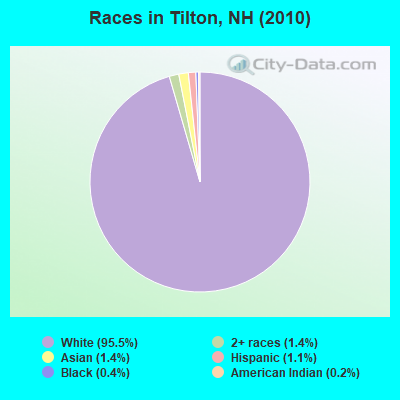
Races in Tilton detailed stats: ancestries, foreign born residents, place of birth
According to our research of New Hampshire and other state lists, there were 12 registered sex offenders living in Tilton, New Hampshire as of April 26, 2024.
The ratio of all residents to sex offenders in Tilton is 297 to 1.
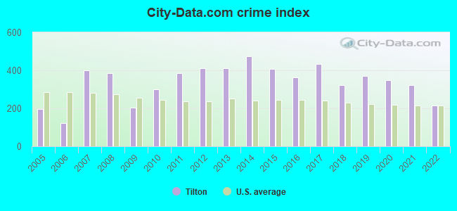
Type |
2009 |
2010 |
2011 |
2012 |
2013 |
2014 |
2015 |
2016 |
2017 |
2018 |
2019 |
2020 |
2021 |
2022 |
|---|---|---|---|---|---|---|---|---|---|---|---|---|---|---|
| Murders (per 100,000) | 0 (0.0) | 0 (0.0) | 0 (0.0) | 0 (0.0) | 0 (0.0) | 0 (0.0) | 0 (0.0) | 0 (0.0) | 0 (0.0) | 0 (0.0) | 0 (0.0) | 0 (0.0) | 0 (0.0) | 0 (0.0) |
| Rapes (per 100,000) | 0 (0.0) | 0 (0.0) | 2 (56.0) | 4 (111.7) | 4 (110.4) | 5 (139.5) | 3 (83.9) | 3 (83.6) | 6 (168.7) | 1 (27.9) | 3 (84.3) | 4 (112.8) | 4 (111.0) | 1 (24.4) |
| Robberies (per 100,000) | 1 (27.7) | 3 (84.1) | 3 (84.0) | 3 (83.8) | 5 (138.0) | 4 (111.6) | 0 (0.0) | 1 (27.9) | 2 (56.2) | 2 (55.9) | 2 (56.2) | 0 (0.0) | 0 (0.0) | 1 (24.4) |
| Assaults (per 100,000) | 1 (27.7) | 9 (252.3) | 8 (224.0) | 9 (251.3) | 1 (27.6) | 4 (111.6) | 8 (223.8) | 7 (195.1) | 5 (140.6) | 8 (223.4) | 8 (224.9) | 6 (169.2) | 8 (222.1) | 3 (73.1) |
| Burglaries (per 100,000) | 14 (388.5) | 17 (476.6) | 24 (671.9) | 17 (474.7) | 29 (800.4) | 19 (530.0) | 16 (447.6) | 10 (278.7) | 13 (365.6) | 16 (446.8) | 8 (224.9) | 15 (423.0) | 4 (111.0) | 4 (97.4) |
| Thefts (per 100,000) | 138 (3,829) | 155 (4,345) | 187 (5,235) | 180 (5,027) | 190 (5,244) | 234 (6,527) | 233 (6,517) | 199 (5,546) | 187 (5,259) | 169 (4,719) | 185 (5,201) | 157 (4,428) | 148 (4,109) | 154 (3,751) |
| Auto thefts (per 100,000) | 5 (138.7) | 8 (224.3) | 6 (168.0) | 5 (139.6) | 5 (138.0) | 4 (111.6) | 2 (55.9) | 3 (83.6) | 7 (196.9) | 9 (251.3) | 8 (224.9) | 7 (197.4) | 8 (222.1) | 9 (219.2) |
| Arson (per 100,000) | 1 (27.7) | 1 (28.0) | 1 (28.0) | 0 (0.0) | 0 (0.0) | 1 (27.9) | 0 (0.0) | 1 (27.9) | 0 (0.0) | 0 (0.0) | 1 (28.1) | 2 (56.4) | 0 (0.0) | 0 (0.0) |
| City-Data.com crime index | 205.3 | 300.8 | 384.7 | 410.2 | 412.1 | 474.5 | 408.4 | 362.3 | 431.7 | 323.9 | 371.1 | 346.6 | 323.2 | 215.8 |
The City-Data.com crime index weighs serious crimes and violent crimes more heavily. Higher means more crime, U.S. average is 246.1. It adjusts for the number of visitors and daily workers commuting into cities.
Crime rate in Tilton detailed stats: murders, rapes, robberies, assaults, burglaries, thefts, arson
Full-time law enforcement employees in 2021, including police officers: 18 (13 officers - 9 male; 4 female).
| Officers per 1,000 residents here: | 3.61 |
| New Hampshire average: | 2.14 |
 Recent articles from our blog. Our writers, many of them Ph.D. graduates or candidates, create easy-to-read articles on a wide variety of topics.

 | Move to NH - Suggested Areas & Towns? (108 replies) |
| What's it like to live in or near Plymouth? (6 replies) |
| Snowpockacylipicsic bomb cyclone (7 replies) |
| Prepared Thanksgiving Dinner from Market Basket or Hannafords in NH? (15 replies) |
| Franklin revit, moving to from ATX (10 replies) |
| Who actually likes living in New Hampshire? ;-) (59 replies) |
Latest news from Tilton, NH collected exclusively by city-data.com from local newspapers, TV, and radio stations
Ancestries: English (18.7%), French (17.7%), Irish (16.7%), French Canadian (11.8%), United States (9.1%), Italian (7.8%).
Current Local Time: EST time zone
Incorporated in 1869
Elevation: 458 feet
Land area: 11.4 square miles.
Population density: 312 people per square mile (very low).
41 residents are foreign born
| This town: | 1.2% |
| New Hampshire: | 4.4% |
| Tilton town: | 2.3% ($2,000) |
| New Hampshire: | 2.3% ($2,946) |
Nearest city with pop. 50,000+: Manchester, NH  (33.7 miles , pop. 107,006).
Nearest city with pop. 200,000+: Boston, MA (82.8 miles , pop. 589,141).
Nearest city with pop. 1,000,000+: Bronx, NY (216.3 miles , pop. 1,332,650).
Nearest cities:
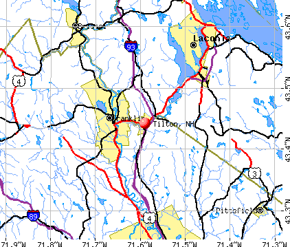
), ), Latitude: 43.47 N, Longitude: 71.57 W
Area code: 603

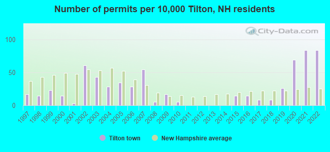
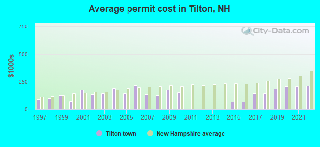
Single-family new house construction building permits:
- 2022: 29 buildings, average cost: $213,000
- 2021: 29 buildings, average cost: $208,100
- 2020: 24 buildings, average cost: $208,100
- 2019: 9 buildings, average cost: $188,700
- 2018: 3 buildings, average cost: $149,000
- 2017: 3 buildings, average cost: $149,000
- 2016: 5 buildings, average cost: $66,000
- 2015: 5 buildings, average cost: $66,000
- 2010: 2 buildings, average cost: $155,000
- 2009: 6 buildings, average cost: $178,900
- 2008: 2 buildings, average cost: $127,500
- 2007: 19 buildings, average cost: $138,200
- 2006: 10 buildings, average cost: $215,500
- 2005: 12 buildings, average cost: $145,800
- 2004: 10 buildings, average cost: $192,500
- 2003: 15 buildings, average cost: $145,000
- 2002: 21 buildings, average cost: $137,800
- 2001: 1 building, cost: $180,000
- 2000: 5 buildings, average cost: $70,000
- 1999: 8 buildings, average cost: $131,300
- 1998: 5 buildings, average cost: $97,800
- 1997: 6 buildings, average cost: $89,700
| Here: | 2.0% |
| New Hampshire: | 2.5% |
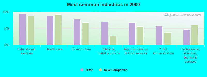
- Educational services (9.3%)
- Health care (8.6%)
- Construction (7.9%)
- Metal & metal products (7.0%)
- Accommodation & food services (6.8%)
- Public administration (5.7%)
- Professional, scientific, technical services (4.7%)
- Construction (13.8%)
- Metal & metal products (10.8%)
- Accommodation & food services (7.1%)
- Public administration (5.9%)
- Educational services (5.7%)
- Professional, scientific, technical services (4.2%)
- Computer & electronic products (4.0%)
- Health care (16.3%)
- Educational services (13.5%)
- Accommodation & food services (6.6%)
- Public administration (5.4%)
- Professional, scientific, technical services (5.2%)
- Food & beverage stores (4.8%)
- Social assistance (4.0%)
- Metal workers and plastic workers (7.9%)
- Other production occupations, including supervisors (5.8%)
- Other management occupations, except farmers and farm managers (5.5%)
- Electrical equipment mechanics and other installation, maintenance, and repair workers, including supervisors (5.2%)
- Driver/sales workers and truck drivers (4.4%)
- Preschool, kindergarten, elementary, and middle school teachers (4.0%)
- Other sales and related occupations, including supervisors (3.8%)
- Metal workers and plastic workers (11.3%)
- Electrical equipment mechanics and other installation, maintenance, and repair workers, including supervisors (9.7%)
- Driver/sales workers and truck drivers (8.1%)
- Other production occupations, including supervisors (6.2%)
- Other management occupations, except farmers and farm managers (5.2%)
- Retail sales workers, except cashiers (3.3%)
- Construction laborers (3.2%)
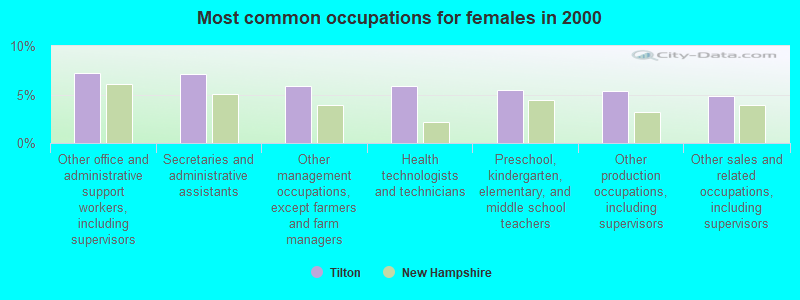
- Other office and administrative support workers, including supervisors (7.2%)
- Secretaries and administrative assistants (7.1%)
- Other management occupations, except farmers and farm managers (5.8%)
- Health technologists and technicians (5.8%)
- Preschool, kindergarten, elementary, and middle school teachers (5.5%)
- Other production occupations, including supervisors (5.4%)
- Other sales and related occupations, including supervisors (4.9%)
Average climate in Tilton, New Hampshire
Based on data reported by over 4,000 weather stations


(lower is better)
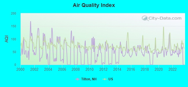
Air Quality Index (AQI) level in 2022 was 51.1. This is significantly better than average.
| City: | 51.1 |
| U.S.: | 72.6 |
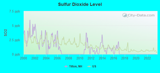
Sulfur Dioxide (SO2) [ppb] level in 2016 was 1.05. This is significantly better than average. Closest monitor was 17.3 miles away from the city center.
| City: | 1.05 |
| U.S.: | 1.51 |
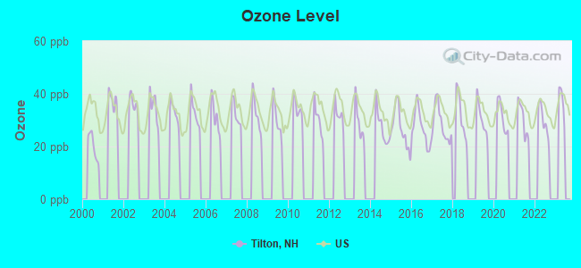
Ozone [ppb] level in 2022 was 29.6. This is about average. Closest monitor was 7.8 miles away from the city center.
| City: | 29.6 |
| U.S.: | 33.3 |
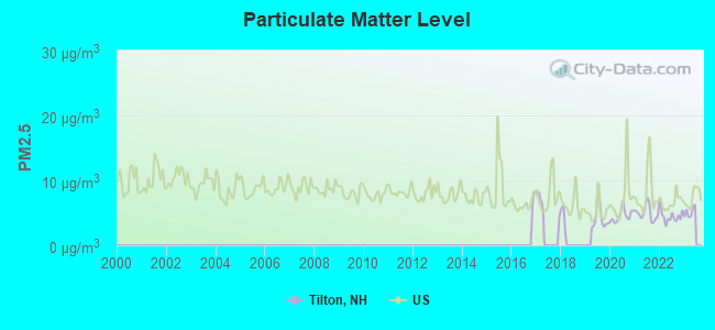
Particulate Matter (PM2.5) [µg/m3] level in 2022 was 4.52. This is significantly better than average. Closest monitor was 6.0 miles away from the city center.
| City: | 4.52 |
| U.S.: | 8.11 |
Tornado activity:
Tilton-area historical tornado activity is near New Hampshire state average. It is 56% smaller than the overall U.S. average.
On 7/3/1972, a category F2 (max. wind speeds 113-157 mph) tornado 7.7 miles away from the Tilton town center injured 7 people and caused between $5000 and $50,000 in damages.
On 7/6/1999, a category F2 tornado 16.6 miles away from the town center .
Earthquake activity:
Tilton-area historical earthquake activity is significantly above New Hampshire state average. It is 71% smaller than the overall U.S. average.On 4/20/2002 at 10:50:47, a magnitude 5.3 (5.3 ML, Depth: 3.0 mi, Class: Moderate, Intensity: VI - VII) earthquake occurred 128.3 miles away from Tilton center
On 1/19/1982 at 00:14:42, a magnitude 4.7 (4.5 MB, 4.7 MD, 4.5 LG, Class: Light, Intensity: IV - V) earthquake occurred 2.8 miles away from the city center
On 10/7/1983 at 10:18:46, a magnitude 5.3 (5.1 MB, 5.3 LG, 5.1 ML) earthquake occurred 142.7 miles away from Tilton center
On 4/20/2002 at 10:50:47, a magnitude 5.2 (5.2 MB, 4.2 MS, 5.2 MW, 5.0 MW) earthquake occurred 128.2 miles away from Tilton center
On 10/16/2012 at 23:12:25, a magnitude 4.7 (4.7 ML, Depth: 10.0 mi) earthquake occurred 46.7 miles away from the city center
On 8/21/1996 at 07:54:14, a magnitude 3.8 (3.8 LG, 3.6 LG, Depth: 6.2 mi, Class: Light, Intensity: II - III) earthquake occurred 50.8 miles away from the city center
Magnitude types: regional Lg-wave magnitude (LG), body-wave magnitude (MB), duration magnitude (MD), local magnitude (ML), surface-wave magnitude (MS), moment magnitude (MW)
Natural disasters:
The number of natural disasters in Belknap County (25) is a lot greater than the US average (15).Major Disasters (Presidential) Declared: 16
Emergencies Declared: 7
Causes of natural disasters: Floods: 10, Storms: 10, Winter Storms: 4, Hurricanes: 3, Snows: 2, Tropical Storms: 2, Blizzard: 1, Heavy Rain: 1, Ice Storm: 1, Snowfall: 1, Snowstorm: 1, Tornado: 1, Wind: 1, Other: 1 (Note: some incidents may be assigned to more than one category).

Hospitals and medical centers near Tilton:
- VNA OF FRANKLIN (Home Health Center, about 4 miles away; FRANKLIN, NH)
- MOUNTAIN RIDGE CENTER, GENESIS HEALTHCARE (Nursing Home, about 4 miles away; FRANKLIN, NH)
- FRANKLIN REGIONAL HOSPITAL Critical Access Hospitals (about 4 miles away; FRANKLIN, NH)
- MERRILL MANOR NURSING HOME (Nursing Home, about 5 miles away; FRANKLIN, NH)
- MERRILL MANOR ANNEX (Nursing Home, about 5 miles away; FRANKLIN, NH)
- SAINT FRANCIS REHABILITATION AND NURSING CENTER (Nursing Home, about 6 miles away; LACONIA, NH)
- LACONIA CENTER, GENESIS HEALTHCARE (Nursing Home, about 7 miles away; LACONIA, NH)
Colleges/universities with over 2000 students nearest to Tilton:
- NHTI-Concord's Community College (about 17 miles; Concord, NH; Full-time enrollment: 2,865)
- Plymouth State University (about 22 miles; Plymouth, NH; FT enrollment: 4,838)
- Southern New Hampshire University (about 31 miles; Manchester, NH; FT enrollment: 16,552)
- Saint Anselm College (about 34 miles; Manchester, NH; FT enrollment: 2,059)
- Mount Washington College (about 35 miles; Manchester, NH; FT enrollment: 2,187)
- University of New Hampshire-Main Campus (about 40 miles; Durham, NH; FT enrollment: 15,243)
- Dartmouth College (about 40 miles; Hanover, NH; FT enrollment: 6,030)
Public high school in Tilton:
- WINNISQUAM REGIONAL HIGH SCHOOL (Students: 572, Location: 435 W. MAIN ST., Grades: 9-12)
Private high school in Tilton:
- TILTON SCHOOL (Students: 248, Location: 30 SCHOOL ST, Grades: 9-12)
Public elementary/middle school in Tilton:
- WINNISQUAM REGIONAL MIDDLE SCHOOL (Students: 397, Location: 76 WINTER ST., Grades: 6-8)
Points of interest:
Notable locations in Tilton: Tilton Northfield Fire and Emergency Medical Services Center Street (A), Tilton School Library (B), The Terraces Building (C), Central New Hampshire Special Operations Unit (D). Display/hide their locations on the map
Churches in Tilton include: Northfield Tilton Congregational Church (A), Fred Andrew Small Chapel (B), Calvary Independent Baptist Church (C), Saint Mary Assumption Church (D), Lakes Region Church of Christ (E), Praise Assembly of God Church (F), Tilton-Northfield United Methodist Church (G). Display/hide their locations on the map
Cemeteries: Park Cemetery (1), Saint Johns Cemetery (2). Display/hide their locations on the map
Lake: Silver Lake (A). Display/hide its location on the map
Streams, rivers, and creeks: Tioga River (A), Winding Hill Brook (B), Packer Brook (C), Hunt Brook (D), Gulf Brook (E). Display/hide their locations on the map
Park in Tilton: Tilton Downtown Historic District (1). Display/hide its location on the map
Hotels: Black Swan Inn (354 West Main Street) (1), Tilton/Lake Winnipesaukee Super 8 Motel (7 Tilton Rd) (2), Three Maples Cottage (957 Laconia Rd) (3), Country Lake Resort (Winnisquam Lake) (4), Anchorage On Lake Winnisquam Inc (725 Laconia Road) (5). Display/hide their approximate locations on the map
Birthplace of: William Hamilton Page - Graphic designer, Harry Taylor (engineer) - General.
Drinking water stations with addresses in Tilton and their reported violations in the past:
TILTON SUPER 8 MOTEL (Population served: 160, Groundwater):Past monitoring violations:WCLC 1 AND 2 (Population served: 52, Groundwater):
- Monitoring, Source Water (GWR) - Between AUG-26-2011 and SEP-26-2011, Contaminant: E. COLI. Follow-up actions: St Public Notif requested (NOV-10-2011), St Violation/Reminder Notice (NOV-10-2011), St Compliance achieved (NOV-10-2011), St Public Notif received (DEC-12-2011)
- Monitoring, Repeat Major (TCR) - Between JUL-2011 and SEP-2011, Contaminant: Coliform (TCR). Follow-up actions: St Public Notif requested (NOV-10-2011), St Violation/Reminder Notice (NOV-10-2011), St Compliance achieved (NOV-10-2011), St Public Notif received (DEC-12-2011)
- 5 routine major monitoring violations
Past health violations:TILTON SHOP EXPRESS (Population served: 40, Groundwater):Past monitoring violations:
- MCL, Monthly (TCR) - Between JUL-2007 and SEP-2007, Contaminant: Coliform. Follow-up actions: St Public Notif requested (SEP-20-2007), St Violation/Reminder Notice (SEP-20-2007), St Compliance achieved (JUN-04-2008), St Public Notif received (JUL-22-2008)
- Monitoring, Repeat Major (TCR) - Between JUL-2007 and SEP-2007, Contaminant: Coliform (TCR). Follow-up actions: St Public Notif requested (OCT-25-2007), St Violation/Reminder Notice (OCT-25-2007), St Public Notif received (DEC-21-2007), St Compliance achieved (MAY-07-2008)
- 13 routine major monitoring violations
Past health violations:WINNISQUAM MARKET AND DELI (Population served: 25, Groundwater):Past monitoring violations:
- MCL, Monthly (TCR) - Between OCT-2013 and DEC-2013, Contaminant: Coliform. Follow-up actions: St Public Notif requested (NOV-07-2013), St Violation/Reminder Notice (NOV-07-2013), St Public Notif received (NOV-20-2013), St Compliance achieved (APR-10-2014)
- MCL, Monthly (TCR) - Between APR-2007 and JUN-2007, Contaminant: Coliform. Follow-up actions: St Public Notif requested (MAY-02-2007), St Violation/Reminder Notice (MAY-02-2007), St Compliance achieved (OCT-31-2007), St Public Notif received (NOV-19-2008)
- Monitoring, Source Water (GWR) - Between OCT-01-2011 and NOV-01-2011, Contaminant: E. COLI. Follow-up actions: St Public Notif requested (OCT-13-2011), St Violation/Reminder Notice (OCT-13-2011), St Compliance achieved (OCT-13-2011), St Public Notif received (OCT-17-2011)
- Monitoring, Repeat Major (TCR) - Between JUL-2011 and SEP-2011, Contaminant: Coliform (TCR). Follow-up actions: St Public Notif requested (OCT-13-2011), St Violation/Reminder Notice (OCT-13-2011), St Compliance achieved (OCT-13-2011), St Public Notif received (OCT-17-2011)
- Monitoring, Repeat Major (TCR) - Between JAN-2007 and MAR-2007, Contaminant: Coliform (TCR). Follow-up actions: St Public Notif requested (MAR-21-2007), St Violation/Reminder Notice (MAR-21-2007), St AO (w/o penalty) issued (MAY-23-2007), St Public Notif received (NOV-19-2008), St Compliance achieved (JAN-07-2009)
- 14 routine major monitoring violations
Past monitoring violations:
- 2 routine major monitoring violations
| This town: | 2.3 people |
| New Hampshire: | 2.5 people |
| This town: | 60.7% |
| Whole state: | 66.3% |
| This town: | 9.4% |
| Whole state: | 8.3% |
Likely homosexual households (counted as self-reported same-sex unmarried-partner households)
- Lesbian couples: 0.8% of all households
- Gay men: 0.3% of all households
| This town: | 5.2% |
| Whole state: | 6.5% |
| This town: | 2.3% |
| Whole state: | 2.8% |
35 people in workers' group living quarters and job corps centers in 2010
People in group quarters in Tilton in 2000:
- 172 people in nursing homes
- 35 people in college dormitories (includes college quarters off campus)
- 11 people in other noninstitutional group quarters
- 9 people in agriculture workers' dormitories on farms
- 4 people in other nonhousehold living situations
Banks with branches in Tilton (2011 data):
- Franklin Savings Bank: Tilton Branch at 61 Laconia Road, Suite 300, branch established on 1999/01/04. Info updated 2006/11/03: Bank assets: $356.8 mil, Deposits: $268.6 mil, headquarters in Franklin, NH, positive income, Mortgage Lending Specialization, 9 total offices
- Northway Bank: Tilton Branch at 5 Market Street, branch established on 1870/05/01. Info updated 2006/04/17: Bank assets: $814.2 mil, Deposits: $619.0 mil, headquarters in Berlin, NH, positive income, Commercial Lending Specialization, 17 total offices, Holding Company: Northway Financial, Inc.
- TD Bank, National Association: Tilton Branch at 10 Sherwood Drive, branch established on 1995/10/30. Info updated 2010/10/04: Bank assets: $188,912.6 mil, Deposits: $153,149.8 mil, headquarters in Wilmington, DE, positive income, 1314 total offices, Holding Company: Toronto-Dominion Bank, The
For population 15 years and over in Tilton:
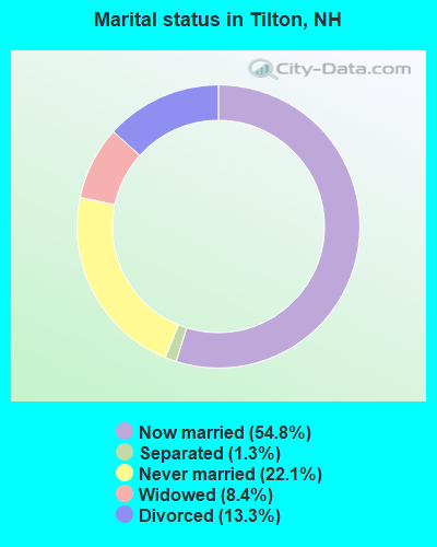
- Never married: 22.1%
- Now married: 54.8%
- Separated: 1.3%
- Widowed: 8.4%
- Divorced: 13.3%
For population 25 years and over in Tilton:
- High school or higher: 79.5%
- Bachelor's degree or higher: 17.7%
- Graduate or professional degree: 4.9%
- Unemployed: 5.0%
- Mean travel time to work (commute): 24.1 minutes
| Here: | 10.6 |
| New Hampshire average: | 10.9 |
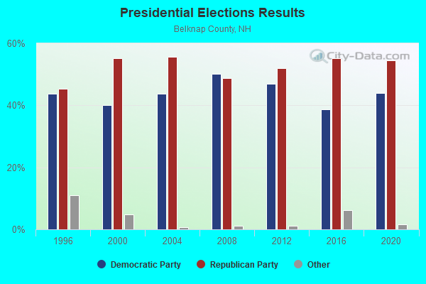
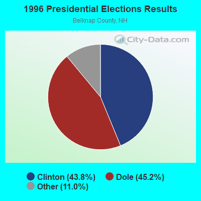


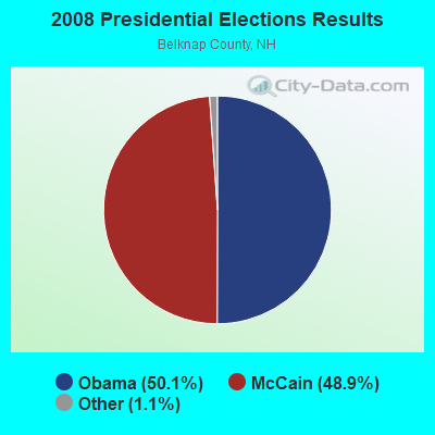
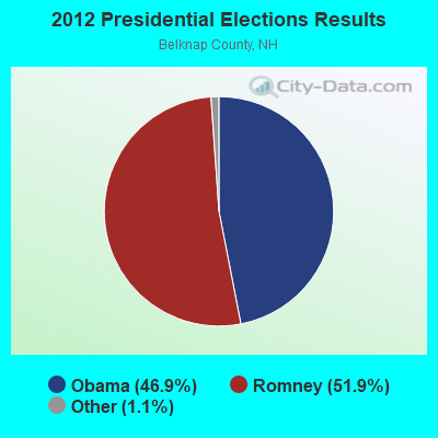


Graphs represent county-level data. Detailed 2008 Election Results
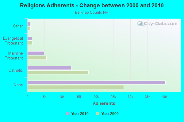
Religion statistics for Tilton, NH (based on Belknap County data)
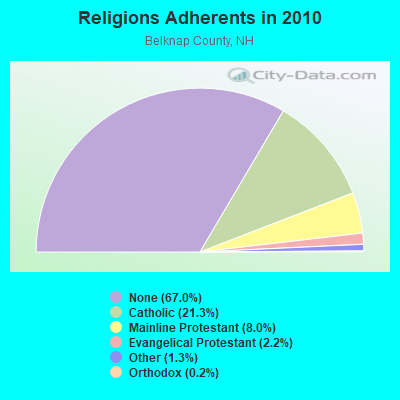
| Religion | Adherents | Congregations |
|---|---|---|
| Catholic | 12,810 | 8 |
| Mainline Protestant | 4,819 | 26 |
| Evangelical Protestant | 1,315 | 19 |
| Other | 793 | 4 |
| Orthodox | 120 | 1 |
| None | 40,231 | - |
Food Environment Statistics:
| Here: | 2.46 / 10,000 pop. |
| New Hampshire: | 2.14 / 10,000 pop. |
| This county: | 0.16 / 10,000 pop. |
| State: | 0.15 / 10,000 pop. |
| Belknap County: | 1.47 / 10,000 pop. |
| New Hampshire: | 1.78 / 10,000 pop. |
| This county: | 4.91 / 10,000 pop. |
| State: | 4.02 / 10,000 pop. |
| This county: | 13.10 / 10,000 pop. |
| New Hampshire: | 9.70 / 10,000 pop. |
| This county: | 8.5% |
| State: | 7.6% |
| Belknap County: | 25.0% |
| New Hampshire: | 24.4% |
| Belknap County: | 20.8% |
| New Hampshire: | 15.9% |
| Businesses in Tilton, NH | ||||
| Name | Count | Name | Count | |
|---|---|---|---|---|
| Ann Taylor | 1 | Kohl's | 1 | |
| Applebee's | 1 | Lane Bryant | 1 | |
| Banana Republic | 1 | Levi Strauss & Co. | 1 | |
| Bath & Body Works | 1 | Lowe's | 1 | |
| Brooks Brothers | 1 | McDonald's | 1 | |
| Burger King | 1 | Nike | 2 | |
| Casual Male XL | 1 | Nissan | 1 | |
| Circle K | 1 | Old Navy | 1 | |
| Clarks | 1 | Pac Sun | 1 | |
| Dairy Queen | 1 | Pizza Hut | 1 | |
| DressBarn | 1 | Rodeway Inn | 1 | |
| Dressbarn | 1 | Rue21 | 1 | |
| Dunkin Donuts | 3 | Sears | 1 | |
| Eddie Bauer | 1 | Shaw's | 1 | |
| Famous Footwear | 1 | Skechers USA | 1 | |
| FedEx | 2 | Staples | 1 | |
| Ford | 1 | Starbucks | 1 | |
| Gap | 1 | Subaru | 1 | |
| Gymboree | 1 | Super 8 | 1 | |
| H&R Block | 1 | True Value | 1 | |
| Hilton | 1 | U-Haul | 1 | |
| Holiday Inn | 1 | U.S. Cellular | 1 | |
| Home Depot | 1 | UPS | 2 | |
| IZOD | 1 | Verizon Wireless | 1 | |
| J.Crew | 1 | Volkswagen | 1 | |
| Jones New York | 1 | Walgreens | 1 | |
| Justice | 1 | Walmart | 1 | |
| KFC | 1 | Wendy's | 1 | |
Strongest AM radio stations in Tilton:
- WEZS (1350 AM; 5 kW; LACONIA, NH; Owner: GARY W. HAMMOND)
- WFTN (1240 AM; 1 kW; FRANKLIN, NH; Owner: NORTHEAST COMMUNICATIONS CORPORATION)
- WRKO (680 AM; 50 kW; BOSTON, MA; Owner: ENTERCOM BOSTON LICENSE, LLC)
- WEMJ (1490 AM; 1 kW; LACONIA, NH; Owner: WLNH RADIO, INC.)
- WNTK (1020 AM; 10 kW; NEWPORT, NH; Owner: KOOR COMMUNICATIONS, INC.)
- WGIN (930 AM; 10 kW; ROCHESTER, NH; Owner: CAPSTAR TX LIMITED PARTNERSHIP)
- WASR (1420 AM; 5 kW; WOLFEBORO, NH; Owner: RADIO WOLFEBORO, INC.)
- WEEI (850 AM; 50 kW; BOSTON, MA; Owner: ENTERCOM BOSTON LICENSE, LLC)
- WCRN (830 AM; 50 kW; WORCESTER, MA; Owner: CARTER BROADCASTING CORPORATION)
- WGIR (610 AM; 5 kW; MANCHESTER, NH; Owner: CAPSTAR TX LIMITED PARTNERSHIP)
- WPNH (1300 AM; 5 kW; PLYMOUTH, NH; Owner: NORTHEAST COMMUNICATIONS CORPORATION)
- WNNZ (640 AM; 50 kW; WESTFIELD, MA; Owner: CLEAR CHANNEL BROADCASTING LICENSES, INC.)
- WKOX (1200 AM; 50 kW; FRAMINGHAM, MA; Owner: CAPSTAR TX LIMITED PARTNERSHIP)
Strongest FM radio stations in Tilton:
- WFTN-FM (94.1 FM; FRANKLIN, NH; Owner: NORTHEAST COMMUNICATIONS CORPORATION)
- WNHI (93.3 FM; BELMONT, NH; Owner: CONCORD BROADCASTING, L.L.C.)
- WLKZ (104.9 FM; WOLFEBORO, NH; Owner: TELE-MEDIA COMPANY OF NEW HAMPSHIRE, L.L.C.)
- WSCY (106.9 FM; MOULTONBOROUGH, NH; Owner: NORTHEAST COMMUNICATIONS CORPORATION)
- WPNH-FM (100.1 FM; PLYMOUTH, NH; Owner: NORTHEAST COMMUNICATIONS CORPORATION)
- WLNH-FM (98.3 FM; LACONIA, NH; Owner: WLNH RADIO, INC)
- WHDQ (106.1 FM; CLAREMONT, NH; Owner: GREAT NORTHERN RADIO, L.L.C.)
- WVFM (105.7 FM; CAMPTON, NH; Owner: DEVON BROADCASTING COMPANY, INC.)
- WPKQ (103.7 FM; NORTH CONWAY, NH; Owner: CITADEL BROADCASTING COMPANY)
- WHOM (94.9 FM; MT. WASHINGTON, NH; Owner: CITADEL BROADCASTING COMPANY)
- WBHG (101.5 FM; MEREDITH, NH; Owner: WLNH RADIO, INC)
- WJYY (105.5 FM; CONCORD, NH; Owner: CONCORD BROADCASTING, L.L.C.)
- WMEX (106.5 FM; FARMINGTON, NH; Owner: WIMMEX, LLC)
- WVPR (89.5 FM; WINDSOR, VT; Owner: VERMONT PUBLIC RADIO)
- W282AF (104.3 FM; CONCORD, NH; Owner: CONCORD BIBLE FELLOWSHIP)
- WVNH (91.1 FM; CONCORD, NH; Owner: NEW HAMPSHIRE GOSPEL RADIO, INC.)
- WEVH (91.3 FM; HANOVER, NH; Owner: NEW HAMPSHIRE PUBLIC RADIO INC)
- WNTK-FM (99.7 FM; NEW LONDON, NH; Owner: SHEILA E. VINIKOOR)
- WNNH (99.1 FM; HENNIKER, NH; Owner: TELE-MEDIA COMPANY OF NEW HAMPSHIRE, L.L.C.)
- WJJR (98.1 FM; RUTLAND, VT; Owner: 6 JOHNSON ROAD LICENSES, INC.)
TV broadcast stations around Tilton:
- WMEA-TV (Channel 26; BIDDEFORD, ME; Owner: MAINE PUBLIC BROADCASTING CORP.)
- WMTW-TV (Channel 8; POLAND SPRING, ME; Owner: WMTW BROADCAST GROUP, LLC)
- WCSH (Channel 6; PORTLAND, ME; Owner: PACIFIC AND SOUTHERN COMPANY, INC.)
- WENH-TV (Channel 11; DURHAM, NH; Owner: UNIVERSITY OF NEW HAMPSHIRE)
- WPXG (Channel 21; CONCORD, NH; Owner: PAXSON BOSTON-68 LICENSE, INC.)
- National Bridge Inventory (NBI) Statistics
- 8Number of bridges
- 75ft / 22.8mTotal length
- $21,994,000Total costs
- 104,839Total average daily traffic
- 5,112Total average daily truck traffic
FCC Registered Cell Phone Towers:
3 (See the full list of FCC Registered Cell Phone Towers in Tilton)FCC Registered Antenna Towers:
14 (See the full list of FCC Registered Antenna Towers)FCC Registered Private Land Mobile Towers:
1 (See the full list of FCC Registered Private Land Mobile Towers in Tilton, NH)FCC Registered Broadcast Land Mobile Towers:
7 (See the full list of FCC Registered Broadcast Land Mobile Towers)FCC Registered Microwave Towers:
2- Burleigh & March Rds (Lat: 43.473111 Lon: -71.605056), Overall height: 57.9 m, Call Sign: WMG438, Licensee ID: L00176823,
Assigned Frequencies: 947.000 MHz, Grant Date: 08/04/1993, Expiration Date: 04/01/2014, Cancellation Date: 01/23/2014, Registrant: Northeast Communications Corporation, P.O. Box 99, Franklin, NH 03235
- SANBORNTON, 516 Steele Hill Rd (Lat: 43.552556 Lon: -71.578528), Type: Tower, Structure height: 45.7 m, Overall height: 47.2 m, Call Sign: WPTT797,
Assigned Frequencies: 6595.00 MHz, Grant Date: 12/06/2011, Expiration Date: 12/13/2021, Cancellation Date: 04/21/2015, Certifier: Steven T Campbell, Registrant: Holland & Knight LLP, 800 17th Street, N.W., Suite #1100, Washington, DC 20006-3906, Phone: (202) 955-3000, Fax: (202) 955-5564, Email:
FCC Registered Paging Towers:
1- Off Calef Hill Road (Lat: 43.473111 Lon: -71.605056), Call Sign: KNKD581,
Assigned Frequencies: 43.4200 MHz, Expiration Date: 04/01/1999, Cancellation Date: 03/31/1999, Registrant: Mobilemedia Communications, Inc., Debtor-In-Possession, 2101 Wilson Boulevard, Suite 935, Arlington, VA 22201, Phone: (703) 312-5153, Fax: (703) 312-5155, Email:
FCC Registered Maritime Coast & Aviation Ground Towers:
1- 61 Business Park Dr. (Lat: 43.462944 Lon: -71.559750), Type: Pole, Structure height: 1 m, Call Sign: WRCG724,
Assigned Frequencies: 161.975 MHz, 162.025 MHz, Grant Date: 09/26/2018, Expiration Date: 09/26/2028, Certifier: Joseph Dillier, Registrant: Sealite Usa, LLC, 61 Business Park Dr., Tilton, NH 03276, Phone: (603) 737-1314, Email:
FCC Registered Amateur Radio Licenses:
37 (See the full list of FCC Registered Amateur Radio Licenses in Tilton)FAA Registered Aircraft:
5- Aircraft: BEECH F33A (Category: Land, Seats: 5, Weight: Up to 12,499 Pounds, Speed: 138 mph), Engine: CONT MOTOR GTSI0-520-F-K (435 HP) (Reciprocating)
N-Number: 234WW, N234WW, N-234WW, Serial Number: CE-878, Year manufactured: 1979, Airworthiness Date: 06/18/1980, Certificate Issue Date: 12/02/2019
Registrant (Individual): Robert J Dumais, Po Box 295, Tilton, NH 03276 - Aircraft: CESSNA 140 (Category: Land, Seats: 2, Weight: Up to 12,499 Pounds, Speed: 105 mph), Engine: CONT MOTOR C90 SERIES (95 HP) (Reciprocating)
N-Number: 76106, N76106, N-76106, Serial Number: 10503, Year manufactured: 1946, Certificate Issue Date: 08/10/2004
Registrant (Individual): John R Cooper, 91 Clark Rd, Tilton, NH 03276 - Aircraft: SOCATA TBM 700 (Category: Land, Seats: 7, Weight: Up to 12,499 Pounds), Engine: P&W PT6A66D (850 HP) (Turbo-prop)
N-Number: 850HR, N850HR, N-850HR, Serial Number: 625, Year manufactured: 2012, Airworthiness Date: 06/28/2012, Certificate Issue Date: 03/03/2016
Registrant (LLC): Pelican Air Ii LLC, 40 E Main St, Tilton, NH 03276 - Aircraft: HAMMERVOLD JERRY E SCORPION TOO-133 (Category: Land, Seats: 2, Weight: Up to 12,499 Pounds), Engine: Reciprocating
N-Number: 8519Z, N8519Z, N-8519Z, Serial Number: 5227, Certificate Issue Date: 03/08/2016
Registrant (Individual): Robert W Jr Haney, 64 Winter St, Tilton, NH 03276 - Aircraft: PZL BIELSKO/MUELLER NP JANTAR STND SZD 48-1 (Category: Land, Seats: 2, Weight: Up to 12,499 Pounds), Engine: None
N-Number: 932KC, N932KC, N-932KC, Serial Number: B1023, Year manufactured: 1980, Airworthiness Date: 07/12/2004, Certificate Issue Date: 03/16/2019
Registrant (Individual): Kari J Mettinen, 170 Winter St, Tilton, NH 03276
2003 - 2018 National Fire Incident Reporting System (NFIRS) incidents
- Fire incident types reported to NFIRS in Tilton, NH
- 26947.5%Structure Fires
- 19334.1%Outside Fires
- 6912.2%Mobile Property/Vehicle Fires
- 356.2%Other
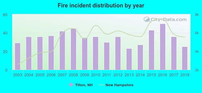 Based on the data from the years 2003 - 2018 the average number of fires per year is 35. The highest number of fire incidents - 50 took place in 2016, and the least - 23 in 2013. The data has a dropping trend.
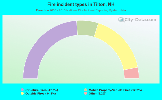 When looking into fire subcategories, the most incidents belonged to: Structure Fires (47.5%), and Outside Fires (34.1%).
Fire-safe hotels and motels in Tilton, New Hampshire:
- Super 8, 7 Tilton Rd, Tilton, New Hampshire 03276 , Phone: (603) 286-8882, Fax: (603) 286-8788
- Holiday Inn Express Hotel And Suites, 75 Tilton Rd, Tilton, New Hampshire 03276 , Phone: (603) 286-4550, Fax: (603) 286-4551
- Hampton Inn And Suites Tilton, 195 Laconia Rd, Tilton, New Hampshire 03276 , Phone: (603) 286-3400, Fax: (603) 286-3407
| Most common first names in Tilton, NH among deceased individuals | ||
| Name | Count | Lived (average) |
|---|---|---|
| John | 207 | 75.0 years |
| George | 186 | 76.1 years |
| William | 186 | 75.7 years |
| Joseph | 165 | 77.7 years |
| Charles | 150 | 74.4 years |
| Robert | 147 | 71.9 years |
| Richard | 111 | 72.2 years |
| James | 102 | 73.4 years |
| Mary | 99 | 75.2 years |
| Arthur | 93 | 80.1 years |
| Most common last names in Tilton, NH among deceased individuals | ||
| Last name | Count | Lived (average) |
|---|---|---|
| Smith | 84 | 72.4 years |
| Robert | 51 | 75.2 years |
| Brown | 45 | 67.8 years |
| Thompson | 36 | 75.7 years |
| Johnson | 33 | 71.1 years |
| Abbott | 30 | 76.3 years |
| Clark | 30 | 77.8 years |
| Hill | 30 | 76.0 years |
| Simpson | 30 | 76.6 years |
| Davis | 30 | 76.3 years |
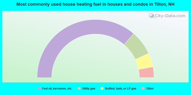
- 72.7%Fuel oil, kerosene, etc.
- 13.7%Utility gas
- 7.7%Bottled, tank, or LP gas
- 3.7%Electricity
- 2.2%Wood
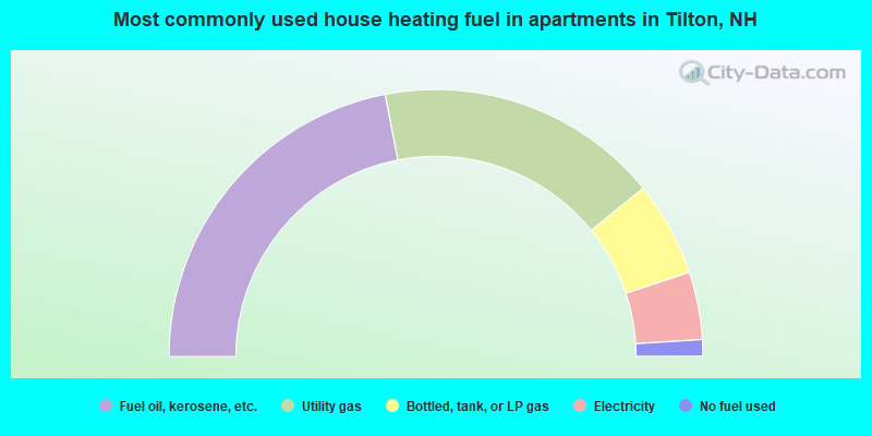
- 43.9%Fuel oil, kerosene, etc.
- 34.4%Utility gas
- 11.5%Bottled, tank, or LP gas
- 8.2%Electricity
- 2.0%No fuel used
Tilton compared to New Hampshire state average:
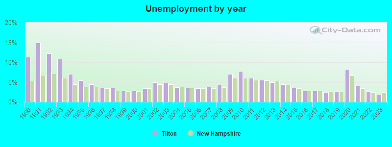
- Unemployed percentage below state average.
- Black race population percentage significantly below state average.
- Hispanic race population percentage significantly below state average.
- Foreign-born population percentage significantly below state average.
- Length of stay since moving in significantly above state average.
- Number of rooms per house significantly below state average.
- House age significantly below state average.
- Institutionalized population percentage significantly above state average.
- Percentage of population with a bachelor's degree or higher below state average.
State forum archive:

|
|
Total of 12 patent applications in 2008-2024.