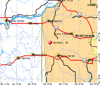
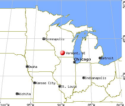
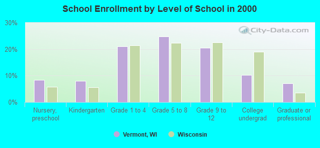
Vermont, Wisconsin
Submit your own pictures of this town and show them to the world
- OSM Map
- General Map
- Google Map
- MSN Map
Population change since 2000: -2.4%
 |
| Males: 411 | |
| Females: 408 |
| Median resident age: | 49.0 years |
| Wisconsin median age: | 42.6 years |
Zip codes: 53515.
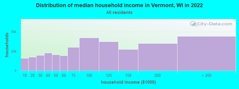
| Vermont: | $112,380 |
| WI: | $70,996 |
Estimated per capita income in 2022: $54,547 (it was $26,549 in 2000)
Vermont town income, earnings, and wages data
Estimated median house or condo value in 2022: $571,715 (it was $224,400 in 2000)
| Vermont: | $571,715 |
| WI: | $252,800 |
Mean prices in 2022: all housing units: $411,151; detached houses: $438,642; townhouses or other attached units: $279,342; in 2-unit structures: $335,997; in 3-to-4-unit structures: $260,203; in 5-or-more-unit structures: $281,289; mobile homes: $129,987
Detailed information about poverty and poor residents in Vermont, WI
Compare current foreclosures near Vermont, WI:
| Photo | Address | Area | Beds / Baths | Price | Details |
|---|---|---|---|---|---|

|
#1
County Road Y
Mazomanie, WI 53560
|
1,080 sq. feet
|
1 baths 2 beds |
show details | |

|
#2
Harbor House Dr Unit 6
Madison, WI 53719
|
- sq. feet
|
- baths - beds |
show details | |

|
#3
Webber Rd Apt 4
Middleton, WI 53562
|
- sq. feet
|
- baths - beds |
show details | |

|
#4
Morraine View Dr Unit 306
Madison, WI 53719
|
- sq. feet
|
- baths - beds |
show details | |

|
#5
King James Way # 9
Madison, WI 53719
|
- sq. feet
|
- baths - beds |
show details | |

|
#6
Century Ave
Middleton, WI 53562
|
- sq. feet
|
- baths - beds |
show details | |

|
#7
Industrial Dr # 210
Verona, WI 53593
|
- sq. feet
|
- baths - beds |
show details | |

|
#8
Mills St # 2
Black Earth, WI 53515
|
- sq. feet
|
- baths - beds |
show details | |

|
#9
Enterprise Dr
Verona, WI 53593
|
- sq. feet
|
- baths - beds |
show details | |

|
#10
Sweeney Dr Apt 1
Middleton, WI 53562
|
- sq. feet
|
- baths - beds |
show details |
| Photo | Address | Area | Beds / Baths | Price | Details |
|---|---|---|---|---|---|

|
#11
South Ave Apt 6
Middleton, WI 53562
|
- sq. feet
|
- baths - beds |
show details | |

|
#12
Stratton Way Apt 307
Madison, WI 53719
|
- sq. feet
|
- baths - beds |
show details | |

|
#13
Prairie Way Cir
Verona, WI 53593
|
- sq. feet
|
- baths - beds |
show details | |

|
#14
Anton Dr Apt 14
Madison, WI 53719
|
- sq. feet
|
- baths - beds |
show details | |

|
#15
W Verona Ave
Verona, WI 53593
|
- sq. feet
|
- baths - beds |
show details | |

|
#16
N Burberry Dr Apt 1117
Madison, WI 53719
|
- sq. feet
|
- baths - beds |
show details | |

|
#17
Lisa Ln # 126
Middleton, WI 53562
|
- sq. feet
|
- baths - beds |
show details | |

|
#18
Parmenter St # 323
Middleton, WI 53562
|
- sq. feet
|
- baths - beds |
show details | |

|
#19
Parmenter St Apt 5
Middleton, WI 53562
|
- sq. feet
|
- baths - beds |
show details | |

|
#20
Saint Andrews Dr
Waunakee, WI 53597
|
- sq. feet
|
- baths - beds |
show details |
| Photo | Address | Area | Beds / Baths | Price | Details |
|---|---|---|---|---|---|

|
#21
Old Sauk Rd
Madison, WI 53717
|
- sq. feet
|
- baths - beds |
show details | |

|
#22
Paoli St Apt 203
Verona, WI 53593
|
- sq. feet
|
- baths - beds |
show details | |

|
#23
Limestone Ln, Apt 326
Madison, WI 53719
|
- sq. feet
|
- baths - beds |
show details | |

|
#24
Fitchrona Rd
Madison, WI 53719
|
- sq. feet
|
- baths - beds |
show details | |

|
#25
Kessel Ct Apt 7
Madison, WI 53711
|
- sq. feet
|
- baths - beds |
show details | |

|
#26
Raymond Rd Apt 4
Madison, WI 53711
|
- sq. feet
|
- baths - beds |
show details | |

|
#27
East Pass Apt 2
Madison, WI 53719
|
- sq. feet
|
- baths - beds |
show details | |

|
#28
Tottenham Rd
Madison, WI 53711
|
- sq. feet
|
- baths - beds |
show details | |

|
#29
Cherbourg Ct
Madison, WI 53711
|
- sq. feet
|
- baths - beds |
show details | |

|
#30
Mckenna Blvd
Madison, WI 53711
|
- sq. feet
|
- baths - beds |
show details |
| Photo | Address | Area | Beds / Baths | Price | Details |
|---|---|---|---|---|---|

|
#31
Raymond Rd # 204
Madison, WI 53711
|
- sq. feet
|
- baths - beds |
show details | |

|
#32
Mckenna Blvd Apt 2
Madison, WI 53711
|
- sq. feet
|
- baths - beds |
show details | |

|
#33
Pheasant Ln Apt 215
Middleton, WI 53562
|
- sq. feet
|
- baths - beds |
show details | |

|
#34
Whitcomb Dr Apt 7
Madison, WI 53711
|
- sq. feet
|
- baths - beds |
show details | |

|
#35
12th St Apt 902
Prairie Du Sac, WI 53578
|
- sq. feet
|
- baths - beds |
show details | |

|
#36
Brindisi Ct Apt 6
Middleton, WI 53562
|
- sq. feet
|
- baths - beds |
show details | |

|
#37
Schroeder Rd Apt 8
Madison, WI 53711
|
- sq. feet
|
- baths - beds |
show details | |

|
#38
Schroeder Rd Apt 1
Madison, WI 53711
|
- sq. feet
|
- baths - beds |
show details | |

|
#39
Schroeder Rd Apt 2
Madison, WI 53711
|
- sq. feet
|
- baths - beds |
show details | |

|
#40
Salerno Ct Apt 5
Middleton, WI 53562
|
- sq. feet
|
- baths - beds |
show details |
| Photo | Address | Area | Beds / Baths | Price | Details |
|---|---|---|---|---|---|

|
#41
Schroeder Rd Apt 109
Madison, WI 53711
|
- sq. feet
|
- baths - beds |
show details | |

|
#42
S Gammon Rd Apt 1
Madison, WI 53719
|
- sq. feet
|
- baths - beds |
show details | |

|
#43
Kessel Ct Apt 37
Madison, WI 53711
|
- sq. feet
|
- baths - beds |
show details | |

|
#44
Town And Country Ln
Waunakee, WI 53597
|
- sq. feet
|
- baths - beds |
show details | |

|
#45
Mayo Dr Apt 304
Madison, WI 53719
|
- sq. feet
|
- baths - beds |
show details | |

|
#46
Angelus Way
Cross Plains, WI 53528
|
- sq. feet
|
- baths - beds |
show details | |

|
#47
S Cincinnati St
Spring Green, WI 53588
|
- sq. feet
|
- baths - beds |
show details | |

|
#48
Watts Rd, Apt 212
Verona, WI 53593
|
- sq. feet
|
- baths - beds |
show details | |

|
#49
Bear Claw Way Apt 306
Madison, WI 53717
|
- sq. feet
|
- baths - beds |
show details | |

|
Check over 1 million property listings on Foreclosure.com!
|
browse all offers | |||

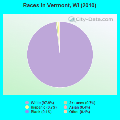
- 80297.9%White alone
- 60.7%Two or more races
- 60.7%Hispanic
- 30.4%Asian alone
- 10.1%Black alone
- 10.1%Other race alone
Races in Vermont detailed stats: ancestries, foreign born residents, place of birth
 Recent articles from our blog. Our writers, many of them Ph.D. graduates or candidates, create easy-to-read articles on a wide variety of topics.

 | Debating whether to relocate to Madison, WI (4 replies) |
| Talk to me about what you love about Madison... (55 replies) |
| Madison - The Best and The Worst (50 replies) |
| small crunchy town outside Madison? (10 replies) |
| Best areas to get land near Madison? (6 replies) |
| Moving from Orange County, CA to Madison ? (97 replies) |
Latest news from Vermont, WI collected exclusively by city-data.com from local newspapers, TV, and radio stations
Ancestries: German (43.9%), Norwegian (26.1%), Irish (14.8%), English (9.2%), Swiss (6.9%), Swedish (2.9%).
Current Local Time: CST time zone
Land area: 35.8 square miles.
Population density: 23 people per square mile (very low).
9 residents are foreign born
| This town: | 1.1% |
| Wisconsin: | 3.6% |
| Vermont town: | 1.0% ($2,205) |
| Wisconsin: | 2.0% ($2,245) |
Nearest city with pop. 50,000+: Madison, WI  (19.2 miles , pop. 208,054).
Nearest city with pop. 1,000,000+: Chicago, IL (137.1 miles , pop. 2,896,016).
Nearest cities:
), ), ), )Latitude: 43.08 N, Longitude: 89.77 W
Area code commonly used in this area: 608

| Here: | 2.0% |
| Wisconsin: | 2.7% |
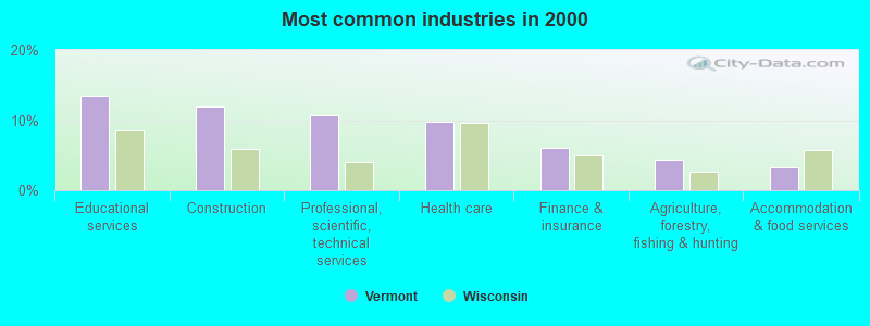
- Educational services (13.5%)
- Construction (12.0%)
- Professional, scientific, technical services (10.7%)
- Health care (9.8%)
- Finance & insurance (6.1%)
- Agriculture, forestry, fishing & hunting (4.3%)
- Accommodation & food services (3.3%)
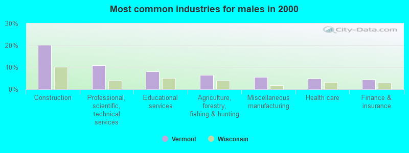
- Construction (20.3%)
- Professional, scientific, technical services (11.0%)
- Educational services (8.1%)
- Agriculture, forestry, fishing & hunting (6.5%)
- Miscellaneous manufacturing (5.7%)
- Health care (4.9%)
- Finance & insurance (4.5%)
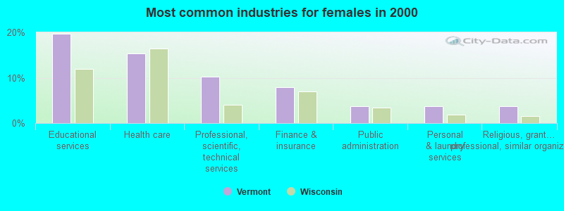
- Educational services (19.6%)
- Health care (15.4%)
- Professional, scientific, technical services (10.3%)
- Finance & insurance (7.9%)
- Public administration (3.7%)
- Personal & laundry services (3.7%)
- Religious, grantmaking, civic, professional, similar organizations (3.7%)
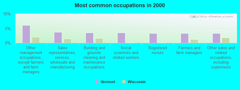
- Other management occupations, except farmers and farm managers (6.1%)
- Sales representatives, services, wholesale and manufacturing (3.7%)
- Building and grounds cleaning and maintenance occupations (3.5%)
- Social scientists and related workers (3.5%)
- Registered nurses (3.3%)
- Farmers and farm managers (3.3%)
- Other sales and related occupations, including supervisors (3.3%)
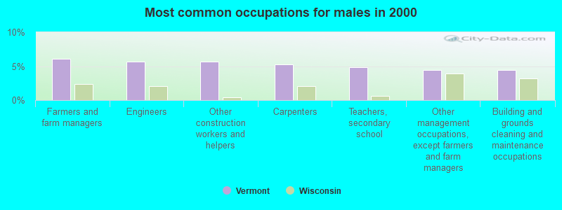
- Farmers and farm managers (6.1%)
- Engineers (5.7%)
- Other construction workers and helpers (5.7%)
- Carpenters (5.3%)
- Teachers, secondary school (4.9%)
- Other management occupations, except farmers and farm managers (4.5%)
- Building and grounds cleaning and maintenance occupations (4.5%)

- Other management occupations, except farmers and farm managers (7.9%)
- Registered nurses (7.0%)
- Social scientists and related workers (6.1%)
- Preschool, kindergarten, elementary, and middle school teachers (5.6%)
- Counselors, social workers, and other community and social service specialists (5.1%)
- Secretaries and administrative assistants (4.7%)
- Art and design workers (3.7%)
Average climate in Vermont, Wisconsin
Based on data reported by over 4,000 weather stations


(lower is better)
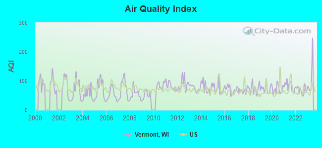
Air Quality Index (AQI) level in 2022 was 68.0. This is about average.
| City: | 68.0 |
| U.S.: | 72.6 |
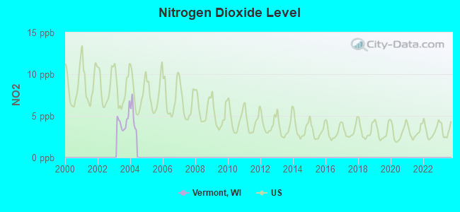
Nitrogen Dioxide (NO2) [ppb] level in 2003 was 4.36. This is about average. Closest monitor was 9.3 miles away from the city center.
| City: | 4.36 |
| U.S.: | 5.11 |
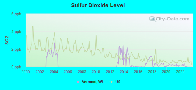
Sulfur Dioxide (SO2) [ppb] level in 2022 was 0.176. This is significantly better than average. Closest monitor was 9.3 miles away from the city center.
| City: | 0.176 |
| U.S.: | 1.515 |
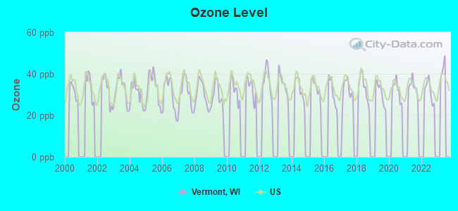
Ozone [ppb] level in 2022 was 31.8. This is about average. Closest monitor was 18.2 miles away from the city center.
| City: | 31.8 |
| U.S.: | 33.3 |
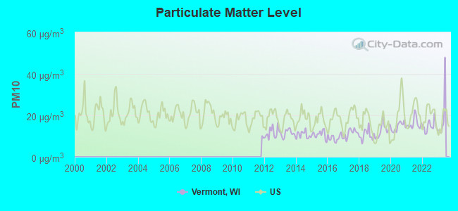
Particulate Matter (PM10) [µg/m3] level in 2022 was 14.7. This is better than average. Closest monitor was 17.1 miles away from the city center.
| City: | 14.7 |
| U.S.: | 19.2 |
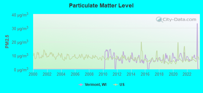
Particulate Matter (PM2.5) [µg/m3] level in 2022 was 7.51. This is about average. Closest monitor was 20.1 miles away from the city center.
| City: | 7.51 |
| U.S.: | 8.11 |
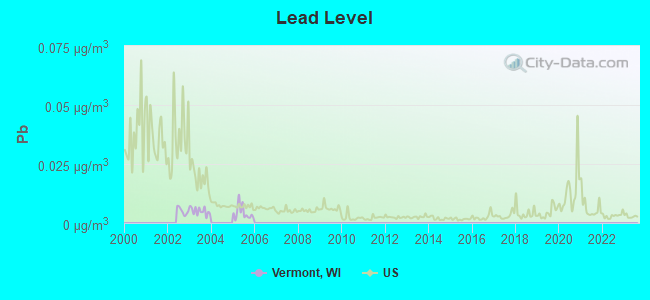
Lead (Pb) [µg/m3] level in 2005 was 0.00428. This is significantly better than average. Closest monitor was 18.7 miles away from the city center.
| City: | 0.00428 |
| U.S.: | 0.00931 |
Tornado activity:
Vermont-area historical tornado activity is above Wisconsin state average. It is 66% greater than the overall U.S. average.
On 6/7/1984, a category F5 (max. wind speeds 261-318 mph) tornado 13.0 miles away from the Vermont town center killed 9 people and injured 200 people and caused between $50,000 and $500,000 in damages.
On 7/3/1983, a category F4 (max. wind speeds 207-260 mph) tornado 19.6 miles away from the town center caused between $5000 and $50,000 in damages.
Earthquake activity:
Vermont-area historical earthquake activity is significantly above Wisconsin state average. It is 45% greater than the overall U.S. average.On 4/18/2008 at 09:36:59, a magnitude 5.4 (5.1 MB, 4.8 MS, 5.4 MW, 5.2 MW, Class: Moderate, Intensity: VI - VII) earthquake occurred 335.2 miles away from Vermont center
On 6/28/2004 at 06:10:52, a magnitude 4.2 (4.2 MW, Depth: 6.2 mi, Class: Light, Intensity: IV - V) earthquake occurred 120.8 miles away from the city center
On 6/10/1987 at 23:48:54, a magnitude 5.1 (4.9 MB, 4.4 MS, 4.6 MS, 5.1 LG) earthquake occurred 310.8 miles away from the city center
On 4/18/2008 at 09:36:59, a magnitude 5.2 (5.2 MW, Depth: 8.9 mi) earthquake occurred 335.2 miles away from the city center
On 2/10/2010 at 09:59:35, a magnitude 3.8 (3.8 MW, Depth: 6.2 mi, Class: Light, Intensity: II - III) earthquake occurred 100.8 miles away from the city center
On 9/2/1999 at 16:17:29, a magnitude 3.5 (3.5 LG, Depth: 3.1 mi) earthquake occurred 95.8 miles away from Vermont center
Magnitude types: regional Lg-wave magnitude (LG), body-wave magnitude (MB), surface-wave magnitude (MS), moment magnitude (MW)
Natural disasters:
The number of natural disasters in Dane County (18) is near the US average (15).Major Disasters (Presidential) Declared: 13
Emergencies Declared: 4
Causes of natural disasters: Storms: 12, Floods: 9, Tornadoes: 8, Winds: 2, Winter Storms: 2, Drought: 1, Hurricane: 1, Landslide: 1, Snow: 1, Snowstorm: 1, Other: 1 (Note: some incidents may be assigned to more than one category).
Hospitals and medical centers near Vermont:
- HEARTLAND COUNTRY VILLAGE (Nursing Home, about 5 miles away; BLACK EARTH, WI)
- REST HAVEN HEALTH CARE CENTER (Nursing Home, about 10 miles away; VERONA, WI)
- UNIV HSPTL HHA (Home Health Center, about 12 miles away; MIDDLETON, WI)
- ATTIC ANGEL PLACE HC (Nursing Home, about 13 miles away; MIDDLETON, WI)
- MAPLEWOOD OF SAUK PRAIRIE (Nursing Home, about 14 miles away; SAUK CITY, WI)
- SOUTHERNCARE MADISON (Hospital, about 14 miles away; MADISON, WI)
- FOUR WINDS MANOR (Nursing Home, about 14 miles away; VERONA, WI)
Colleges/universities with over 2000 students nearest to Vermont:
- Edgewood College (about 18 miles; Madison, WI; Full-time enrollment: 2,455)
- University of Wisconsin-Madison (about 19 miles; Madison, WI; FT enrollment: 34,621)
- University of Wisconsin Colleges (about 19 miles; Madison, WI; FT enrollment: 10,019)
- Madison Area Technical College (about 23 miles; Madison, WI; FT enrollment: 9,603)
- Herzing University-Madison (about 25 miles; Madison, WI; FT enrollment: 3,160)
- University of Wisconsin-Platteville (about 44 miles; Platteville, WI; FT enrollment: 7,679)
- University of Wisconsin-Whitewater (about 55 miles; Whitewater, WI; FT enrollment: 11,124)
Points of interest:
Notable location: Hylee Farm (A). Display/hide its location on the map
Churches in Vermont include: Vermont Lutheran Church (A), Saint James Church (B). Display/hide their locations on the map
Creeks: Ryan Creek (A), Bohn Creek (B), Moen Creek (C), Elvers Creek (D). Display/hide their locations on the map
| This town: | 2.5 people |
| Wisconsin: | 2.4 people |
| This town: | 75.4% |
| Whole state: | 64.4% |
| This town: | 7.1% |
| Whole state: | 7.3% |
Likely homosexual households (counted as self-reported same-sex unmarried-partner households)
- Lesbian couples: 1.2% of all households
- Gay men: 0.6% of all households
| This town: | 2.8% |
| Whole state: | 8.7% |
| This town: | 1.0% |
| Whole state: | 3.7% |
For population 15 years and over in Vermont:
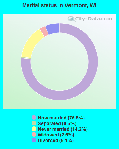
- Never married: 14.2%
- Now married: 76.5%
- Separated: 0.6%
- Widowed: 2.6%
- Divorced: 6.1%
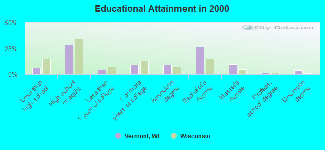
For population 25 years and over in Vermont:
- High school or higher: 93.5%
- Bachelor's degree or higher: 41.9%
- Graduate or professional degree: 15.1%
- Unemployed: 4.2%
- Mean travel time to work (commute): 28.5 minutes
| Here: | 10.5 |
| Wisconsin average: | 11.0 |
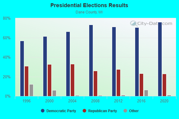
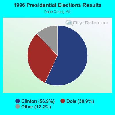
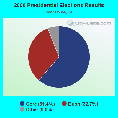
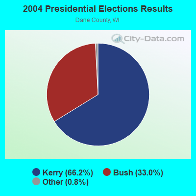
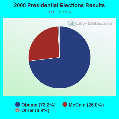
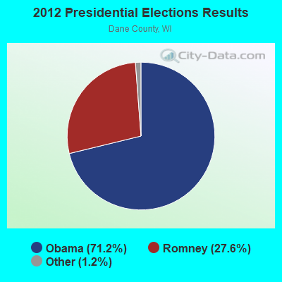
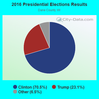
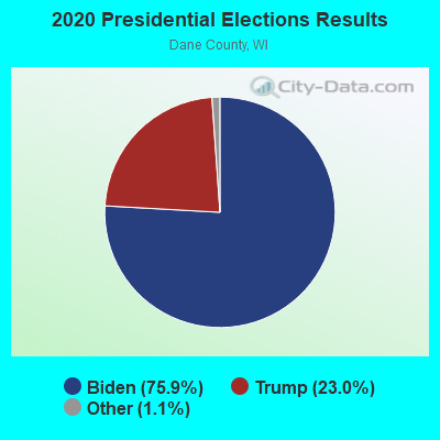
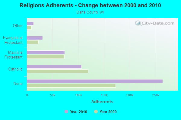
Graphs represent county-level data. Detailed 2008 Election Results
Religion statistics for Vermont, WI (based on Dane County data)
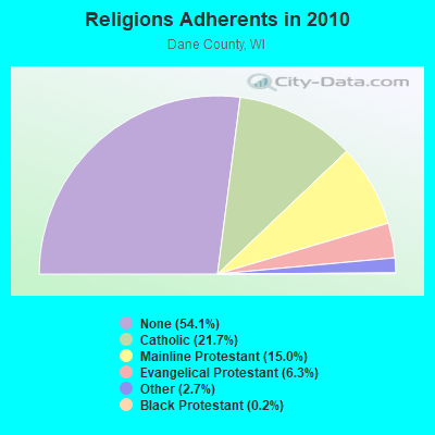
| Religion | Adherents | Congregations |
|---|---|---|
| Catholic | 106,036 | 34 |
| Mainline Protestant | 73,128 | 113 |
| Evangelical Protestant | 30,727 | 146 |
| Other | 12,968 | 49 |
| Black Protestant | 779 | 5 |
| Orthodox | 445 | 4 |
| None | 263,990 | - |
Food Environment Statistics:
| This county: | 1.53 / 10,000 pop. |
| Wisconsin: | 1.86 / 10,000 pop. |
| This county: | 0.04 / 10,000 pop. |
| State: | 0.11 / 10,000 pop. |
| This county: | 0.11 / 10,000 pop. |
| Wisconsin: | 0.38 / 10,000 pop. |
| This county: | 3.24 / 10,000 pop. |
| Wisconsin: | 4.12 / 10,000 pop. |
| Dane County: | 8.03 / 10,000 pop. |
| Wisconsin: | 8.64 / 10,000 pop. |
| This county: | 6.0% |
| Wisconsin: | 7.6% |
| Dane County: | 23.9% |
| Wisconsin: | 27.5% |
| Here: | 11.1% |
| Wisconsin: | 13.0% |
5.62% of this county's 2021 resident taxpayers lived in other counties in 2020 ($67,560 average adjusted gross income)
| Here: | 5.62% |
| Wisconsin average: | 6.07% |
0.01% of residents moved from foreign countries ($96 average AGI)
Dane County: 0.01% Wisconsin average: 0.00%
Top counties from which taxpayers relocated into this county between 2020 and 2021:
| from Milwaukee County, WI | |
| from Cook County, IL | |
| from Rock County, WI |
6.55% of this county's 2020 resident taxpayers moved to other counties in 2021 ($75,791 average adjusted gross income)
| Here: | 6.55% |
| Wisconsin average: | 6.10% |
0.01% of residents moved to foreign countries ($41 average AGI)
Dane County: 0.01% Wisconsin average: 0.00%
Top counties to which taxpayers relocated from this county between 2020 and 2021:
| to Rock County, WI | |
| to Columbia County, WI | |
| to Milwaukee County, WI |
Strongest AM radio stations in Vermont:
- WLMV (1480 AM; 10 kW; MADISON, WI; Owner: MID-WEST MANAGEMENT, INC.)
- WTDY (1670 AM; 10 kW; MADISON, WI; Owner: MID-WEST MANAGEMENT, INC.)
- WTSO (1070 AM; 10 kW; MADISON, WI; Owner: CAPSTAR TX LIMITED PARTNERSHIP)
- WHA (970 AM; 5 kW; MADISON, WI; Owner: BOARD REGENTS OF UNIV OF WI SYSTEM)
- WIBA (1310 AM; 5 kW; MADISON, WI; Owner: CAPSTAR TX LIMITED PARTNERSHIP)
- WTMJ (620 AM; 50 kW; MILWAUKEE, WI; Owner: JOURNAL BROADCAST CORPORATION)
- WTUX (1550 AM; daytime; 5 kW; MADISON, WI)
- WISN (1130 AM; 50 kW; MILWAUKEE, WI; Owner: CAPSTAR TX LIMITED PARTNERSHIP)
- WSCR (670 AM; 50 kW; CHICAGO, IL; Owner: INFINITY BROADCASTING OPERATIONS, INC.)
- WGN (720 AM; 50 kW; CHICAGO, IL; Owner: WGN CONTINENTAL BROADCASTING CO.)
- WNWC (1190 AM; daytime; 5 kW; SUN PRAIRIE, WI; Owner: NORTHWESTERN COLLEGE)
- WSPT (1010 AM; 50 kW; STEVENS POINT, WI)
- WBBM (780 AM; 50 kW; CHICAGO, IL; Owner: INFINITY BROADCASTING OPERATIONS, INC.)
Strongest FM radio stations in Vermont:
- WERN (88.7 FM; MADISON, WI; Owner: STATE OF WISCONSIN - EDUCATIONAL COMMUNICATIONS BOARD)
- WIBA-FM (101.5 FM; MADISON, WI; Owner: CAPSTAR TX LIMITED PARTNERSHIP)
- WZEE (104.1 FM; MADISON, WI; Owner: CAPSTAR TX LIMITED PARTNERSHIP)
- WORT (89.9 FM; MADISON, WI; Owner: BACK PORCH RADIO BROADCASTING, INC.)
- WCJZ (96.3 FM; SAUK CITY, WI; Owner: CAPSTAR TX LIMITED PARTNERSHIP)
- W215AQ (90.9 FM; MADISON, WI; Owner: STATE OF WISCONSIN - EDUCATIONAL COMMUNICATIONS BOARD)
- WOLX-FM (94.9 FM; BARABOO, WI; Owner: ENTERCOM MADISON LICENSE, LLC.)
- WNWC-FM (102.5 FM; MADISON, WI; Owner: NORTHWESTERN COLLEGE)
- WMMM-FM (105.5 FM; VERONA, WI; Owner: ENTERCOM MADISON LICENSE, LLC.)
- WWQM-FM (106.3 FM; MIDDLETON, WI; Owner: MID-WEST MANAGEMENT INC.)
- WMGN (98.1 FM; MADISON, WI; Owner: MID-WEST MANAGEMENT, INC.)
- WSUM (91.7 FM; MADISON, WI; Owner: BD. OF REGENTS OF UNIVERSITY OF WISCONSIN SYSTEM)
- WDMP-FM (99.3 FM; DODGEVILLE, WI; Owner: DODGE POINT BROADCASTING CO., INC.)
- WHHI (91.3 FM; HIGHLAND, WI; Owner: STATE OF WISCONSIN - EDUCATIONAL COMMUNICATIONS BOARD)
- WMAD-FM (92.1 FM; SUN PRAIRIE, WI; Owner: CAPSTAR TX LIMITED PARTNERSHIP)
- W277AE (103.3 FM; MADISON, WI; Owner: FAITH ACADEMY DBA WFEN)
TV broadcast stations around Vermont:
- WISC-TV (Channel 3; MADISON, WI; Owner: TELEVISION WISCONSIN, INC.)
- WMSN-TV (Channel 47; MADISON, WI; Owner: WMSN LICENSEE, LLC)
- WKOW-TV (Channel 27; MADISON, WI; Owner: WKOW TELEVISION, INC.)
- WHA-TV (Channel 21; MADISON, WI; Owner: BOARD OF REGENTS OF THE UNIV. OF WISCONSIN SYSTEM)
- WMTV (Channel 15; MADISON, WI; Owner: GRAY MIDAMERICA TV LICENSEE CORP.)
- W58CO (Channel 58; SAULT STE. MARIE, MI; Owner: MS COMMUNICATIONS, LLC)
- W38CT (Channel 38; MADISON, WI; Owner: TRINITY BROADCASTING NETWORK)
- W23BW (Channel 23; MADISON, WI; Owner: THREE ANGELS BROADCASTING NETWORK)
- W08CK (Channel 8; MADISON-MIDDLETON, WI; Owner: HEALTHY'S, INC.)
- National Bridge Inventory (NBI) Statistics
- 12Number of bridges
- 46ft / 14.1mTotal length
- $316,000Total costs
- 5,694Total average daily traffic
- 286Total average daily truck traffic
- 6,808Total future (year 2039) average daily traffic
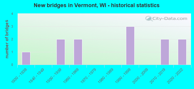
- New bridges - historical statistics
- 11930-1939
- 21950-1959
- 21960-1969
- 31990-1999
- 22010-2019
- 22020-2022
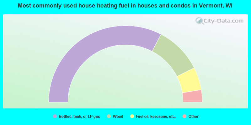
- 65.3%Bottled, tank, or LP gas
- 19.9%Wood
- 9.6%Fuel oil, kerosene, etc.
- 2.8%Utility gas
- 1.6%Solar energy
- 0.8%Electricity
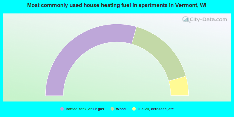
- 58.8%Bottled, tank, or LP gas
- 32.4%Wood
- 8.8%Fuel oil, kerosene, etc.
Vermont compared to Wisconsin state average:
- Median household income above state average.
- Median house value significantly above state average.
- Unemployed percentage significantly below state average.
- Black race population percentage significantly below state average.
- Hispanic race population percentage significantly below state average.
- Median age above state average.
- Foreign-born population percentage significantly below state average.
- Renting percentage significantly below state average.
- Length of stay since moving in significantly above state average.
- Number of rooms per house significantly below state average.
- House age significantly below state average.
- Percentage of population with a bachelor's degree or higher above state average.