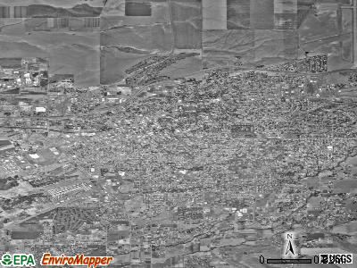
Walla Walla, Washington
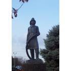
Walla Walla: fireman statue walla walla
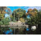
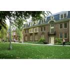
Walla Walla: whitman campus
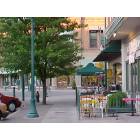
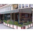
Walla Walla: downtown
Walla Walla: book store
Walla Walla: whitman college 1
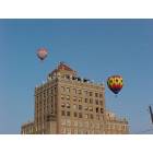
Walla Walla: marcus whitman hotel (downtown)
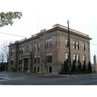
Walla Walla: City Hall
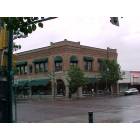
Walla Walla: main & 4th st Downtown. User comment: This picture is 2nd and Main, not 4th and Main. I am looking out my office window at this view as I type.
Walla Walla: coffee shop main st
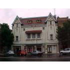
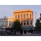
Walla Walla: macys store. User comment: This is the old Liberty Theater on Main Street in Walla Walla. It is now a part of Macy's.
Walla Walla: downtown
- see
60
more - add
your
Submit your own pictures of this city and show them to the world
- OSM Map
- General Map
- Google Map
- MSN Map
Population change since 2000: +12.8%
 |
| Males: 17,302 | |
| Females: 16,190 |
| Median resident age: | 37.6 years |
| Washington median age: | 38.4 years |
Zip codes: 99362.
| Walla Walla: | $58,811 |
| WA: | $91,306 |
Estimated per capita income in 2022: $33,159 (it was $15,792 in 2000)
Walla Walla city income, earnings, and wages data
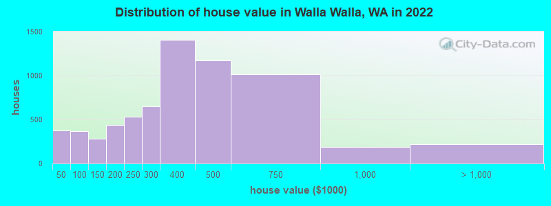
Estimated median house or condo value in 2022: $378,343 (it was $97,100 in 2000)
| Walla Walla: | $378,343 |
| WA: | $569,500 |
Mean prices in 2022: all housing units: $362,736; detached houses: $383,285; townhouses or other attached units: $485,914; in 5-or-more-unit structures: $299,980; mobile homes: $60,509
Median gross rent in 2022: $1,135.
(10.4% for White Non-Hispanic residents, 55.9% for Black residents, 17.7% for Hispanic or Latino residents, 8.0% for American Indian residents, 18.2% for Native Hawaiian and other Pacific Islander residents, 23.5% for other race residents, 15.7% for two or more races residents)
Detailed information about poverty and poor residents in Walla Walla, WA


- 22,11864.5%White alone
- 8,42624.6%Hispanic
- 1,4264.2%Two or more races
- 9952.9%Black alone
- 8592.5%Asian alone
- 1480.4%American Indian alone
- 860.3%Native Hawaiian and Other
Pacific Islander alone - 430.1%Other race alone

Races in Walla Walla detailed stats: ancestries, foreign born residents, place of birth
According to our research of Washington and other state lists, there were 15 registered sex offenders living in Walla Walla, Washington as of April 27, 2024.
The ratio of all residents to sex offenders in Walla Walla is 2,195 to 1.
The ratio of registered sex offenders to all residents in this city is lower than the state average.
Type |
2009 |
2010 |
2011 |
2012 |
2013 |
2014 |
2015 |
2016 |
2017 |
2018 |
2019 |
2020 |
2021 |
2022 |
|---|---|---|---|---|---|---|---|---|---|---|---|---|---|---|
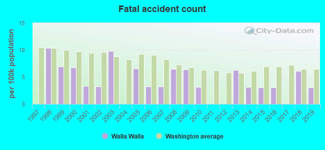
| Murders (per 100,000) | 0 (0.0) | 0 (0.0) | 3 (9.3) | 0 (0.0) | 0 (0.0) | 1 (3.1) | 4 (12.5) | 2 (6.2) | 1 (3.1) | 0 (0.0) | 2 (6.1) | 1 (3.0) | 1 (3.0) | 2 (5.9) |
| Rapes (per 100,000) | 34 (110.9) | 19 (59.9) | 22 (68.3) | 15 (46.2) | 13 (40.8) | 22 (69.1) | 18 (56.4) | 23 (71.2) | 30 (93.2) | 28 (85.1) | 36 (108.9) | 24 (72.9) | 26 (78.4) | 27 (79.6) |
| Robberies (per 100,000) | 16 (52.2) | 23 (72.5) | 20 (62.1) | 18 (55.4) | 14 (43.9) | 12 (37.7) | 23 (72.0) | 17 (52.6) | 24 (74.6) | 12 (36.5) | 16 (48.4) | 11 (33.4) | 7 (21.1) | 10 (29.5) |
| Assaults (per 100,000) | 60 (195.7) | 75 (236.4) | 85 (263.7) | 79 (243.4) | 70 (219.5) | 70 (219.9) | 130 (407.0) | 80 (247.5) | 90 (279.6) | 88 (267.4) | 68 (205.8) | 53 (160.9) | 59 (178.0) | 87 (256.6) |
| Burglaries (per 100,000) | 302 (985.1) | 229 (721.7) | 244 (757.1) | 274 (844.0) | 228 (715.0) | 268 (841.9) | 249 (779.6) | 233 (720.8) | 148 (459.8) | 164 (498.4) | 161 (487.2) | 127 (385.5) | 86 (259.4) | 206 (607.7) |
| Thefts (per 100,000) | 1,065 (3,474) | 1,005 (3,167) | 1,104 (3,425) | 1,101 (3,392) | 1,093 (3,428) | 1,201 (3,773) | 1,187 (3,716) | 1,043 (3,227) | 919 (2,855) | 979 (2,975) | 820 (2,481) | 582 (1,767) | 485 (1,463) | 741 (2,186) |
| Auto thefts (per 100,000) | 54 (176.1) | 57 (179.6) | 35 (108.6) | 71 (218.7) | 69 (216.4) | 94 (295.3) | 96 (300.6) | 99 (306.3) | 66 (205.0) | 60 (182.3) | 77 (233.0) | 50 (151.8) | 50 (150.8) | 90 (265.5) |
| Arson (per 100,000) | 11 (35.9) | 6 (18.9) | 11 (34.1) | 11 (33.9) | 11 (34.5) | 19 (59.7) | 17 (53.2) | 17 (52.6) | 11 (34.2) | 15 (45.6) | 5 (15.1) | 7 (21.2) | 6 (18.1) | 18 (53.1) |
| City-Data.com crime index | 365.5 | 308.5 | 343.3 | 314.5 | 294.1 | 350.3 | 400.4 | 338.6 | 321.8 | 301.0 | 306.9 | 216.3 | 199.4 | 286.9 |
The City-Data.com crime index weighs serious crimes and violent crimes more heavily. Higher means more crime, U.S. average is 246.1. It adjusts for the number of visitors and daily workers commuting into cities.
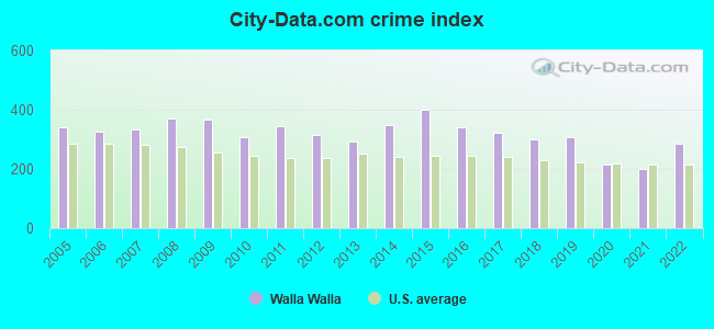
Crime rate in Walla Walla detailed stats: murders, rapes, robberies, assaults, burglaries, thefts, arson
Full-time law enforcement employees in 2021, including police officers: 77 (48 officers - 46 male; 2 female).
| Officers per 1,000 residents here: | 1.45 |
| Washington average: | 1.35 |
 Recent articles from our blog. Our writers, many of them Ph.D. graduates or candidates, create easy-to-read articles on a wide variety of topics.

 | Working in Wallula: live in Tri-Cities or Walla Walla? (4 replies) |
| thoughts on walla walla? (47 replies) |
| Walla Walla High crime rate (3 replies) |
| Walla Walla High Schools, Looking for Work in Adult Ed/ Immigration (1 reply) |
| Internet west of Walla Walla (2 replies) |
| Retiring and buying $450k house possible? (37 replies) |
Latest news from Walla Walla, WA collected exclusively by city-data.com from local newspapers, TV, and radio stations
Ancestries: German (9.4%), American (8.0%), English (5.2%), Irish (5.0%), European (3.3%), Russian (2.6%).
Current Local Time: PST time zone
Incorporated in 1862
Elevation: 1000 feet
Land area: 10.8 square miles.
Population density: 3,097 people per square mile (average).
3,644 residents are foreign born (5.8% Latin America, 1.5% Europe, 1.5% Asia, 1.1% Africa).
| This city: | 10.6% |
| Washington: | 14.9% |
Median real estate property taxes paid for housing units with mortgages in 2022: $2,960 (0.8%)
Median real estate property taxes paid for housing units with no mortgage in 2022: $2,983 (0.8%)
Nearest city with pop. 50,000+: Kennewick, WA  (40.9 miles , pop. 54,693).
Nearest city with pop. 200,000+: East Seattle, WA (210.8 miles , pop. 480,100).
Nearest city with pop. 1,000,000+: Los Angeles, CA (828.6 miles , pop. 3,694,820).
Nearest cities:
), ), ), Latitude: 46.07 N, Longitude: 118.33 W
Daytime population change due to commuting: +6,151 (+17.9%)
Workers who live and work in this city: 13,967 (91.2%)
Area code: 509
Walla Walla tourist attractions:
- Whitman Mission - Walla Walla, Washington - National Historic Site Where the Whitman Massacre Took Place
- Walla Walla Wineries - Walla Walla, Washington - The New Napa Valley of the Northwest
- Marcus Whitman Hotel & Conference Center - Walla Walla, Washington Luxury Hotel Located in Heart of Washington Wine Country
Walla Walla, Washington accommodation & food services, waste management - Economy and Business Data
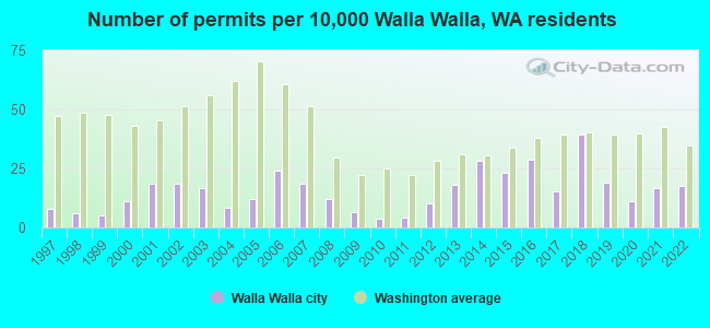
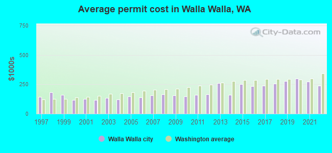
Single-family new house construction building permits:
- 2022: 52 buildings, average cost: $236,500
- 2021: 50 buildings, average cost: $276,200
- 2020: 33 buildings, average cost: $298,400
- 2019: 57 buildings, average cost: $279,400
- 2018: 117 buildings, average cost: $258,400
- 2017: 45 buildings, average cost: $239,600
- 2016: 85 buildings, average cost: $235,600
- 2015: 69 buildings, average cost: $249,900
- 2014: 84 buildings, average cost: $159,500
- 2013: 53 buildings, average cost: $259,100
- 2012: 30 buildings, average cost: $167,100
- 2011: 12 buildings, average cost: $162,200
- 2010: 11 buildings, average cost: $147,200
- 2009: 19 buildings, average cost: $157,600
- 2008: 36 buildings, average cost: $163,900
- 2007: 55 buildings, average cost: $158,000
- 2006: 71 buildings, average cost: $138,400
- 2005: 36 buildings, average cost: $148,700
- 2004: 25 buildings, average cost: $122,500
- 2003: 49 buildings, average cost: $134,200
- 2002: 55 buildings, average cost: $118,800
- 2001: 55 buildings, average cost: $125,000
- 2000: 33 buildings, average cost: $117,400
- 1999: 15 buildings, average cost: $158,600
- 1998: 18 buildings, average cost: $184,100
- 1997: 23 buildings, average cost: $142,400
| Here: | 5.8% |
| Washington: | 4.6% |
Population change in the 1990s: +2,368 (+8.7%).
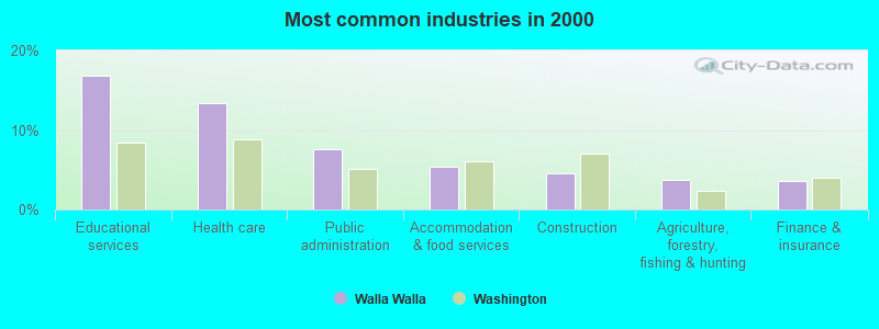
- Educational services (16.8%)
- Health care (13.4%)
- Public administration (7.6%)
- Accommodation & food services (5.4%)
- Construction (4.6%)
- Agriculture, forestry, fishing & hunting (3.7%)
- Finance & insurance (3.5%)
- Educational services (12.7%)
- Public administration (8.8%)
- Health care (8.0%)
- Construction (7.9%)
- Agriculture, forestry, fishing & hunting (5.7%)
- Food (4.3%)
- Accommodation & food services (4.2%)
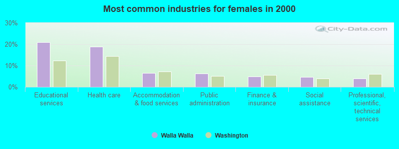
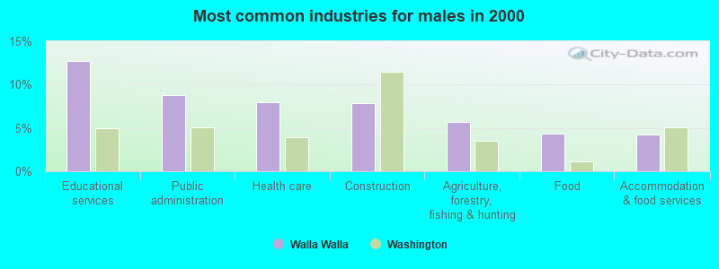
- Educational services (21.0%)
- Health care (18.8%)
- Accommodation & food services (6.5%)
- Public administration (6.4%)
- Finance & insurance (4.9%)
- Social assistance (4.6%)
- Professional, scientific, technical services (4.0%)
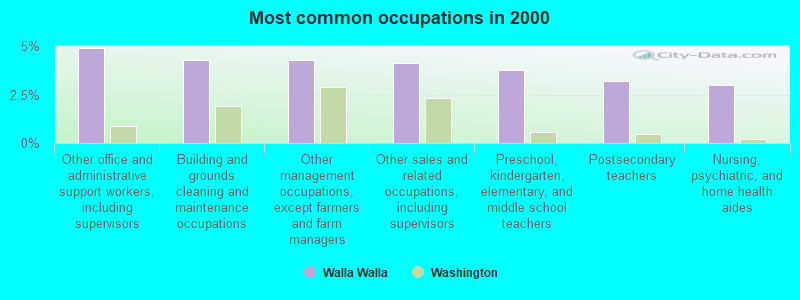
- Other office and administrative support workers, including supervisors (4.9%)
- Building and grounds cleaning and maintenance occupations (4.3%)
- Other management occupations, except farmers and farm managers (4.3%)
- Other sales and related occupations, including supervisors (4.1%)
- Preschool, kindergarten, elementary, and middle school teachers (3.8%)
- Postsecondary teachers (3.2%)
- Nursing, psychiatric, and home health aides (3.0%)
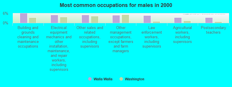
- Building and grounds cleaning and maintenance occupations (6.0%)
- Electrical equipment mechanics and other installation, maintenance, and repair workers, including supervisors (5.1%)
- Other sales and related occupations, including supervisors (5.1%)
- Other management occupations, except farmers and farm managers (4.8%)
- Law enforcement workers, including supervisors (4.7%)
- Agricultural workers, including supervisors (3.4%)
- Postsecondary teachers (3.4%)
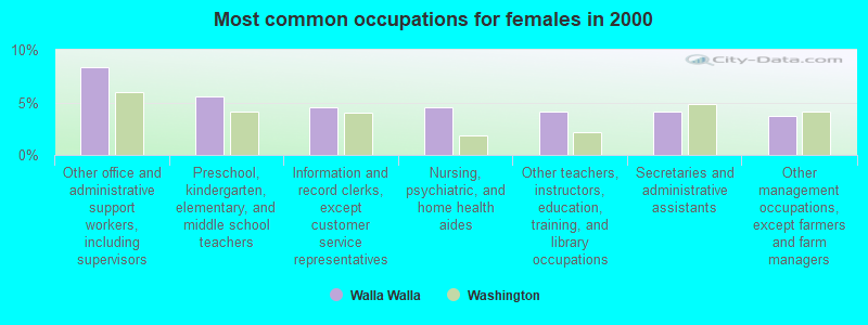
- Other office and administrative support workers, including supervisors (8.4%)
- Preschool, kindergarten, elementary, and middle school teachers (5.6%)
- Information and record clerks, except customer service representatives (4.5%)
- Nursing, psychiatric, and home health aides (4.5%)
- Other teachers, instructors, education, training, and library occupations (4.1%)
- Secretaries and administrative assistants (4.1%)
- Other management occupations, except farmers and farm managers (3.7%)
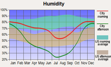
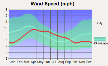
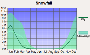
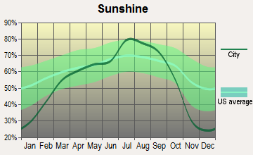
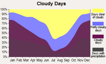
Average climate in Walla Walla, Washington
Based on data reported by over 4,000 weather stations


|
|

(lower is better)
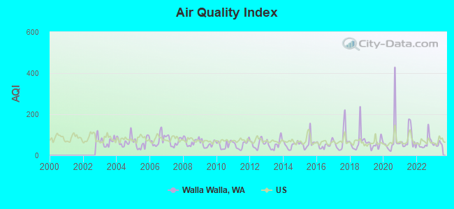
Air Quality Index (AQI) level in 2023 was 54.1. This is better than average.
| City: | 54.1 |
| U.S.: | 72.6 |
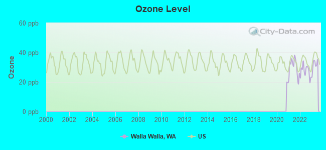
Ozone [ppb] level in 2023 was 31.3. This is about average. Closest monitor was 20.4 miles away from the city center.
| City: | 31.3 |
| U.S.: | 33.3 |
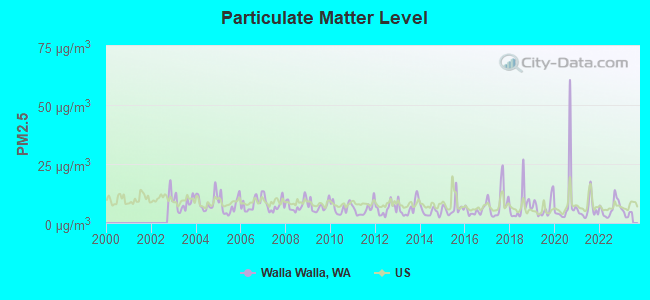
Particulate Matter (PM2.5) [µg/m3] level in 2022 was 6.35. This is better than average. Closest monitor was 1.1 miles away from the city center.
| City: | 6.35 |
| U.S.: | 8.11 |
Earthquake activity:
Walla Walla-area historical earthquake activity is significantly above Washington state average. It is 1237% greater than the overall U.S. average.On 10/28/1983 at 14:06:06, a magnitude 7.3 (6.2 MB, 7.3 MS, 7.0 MW, Class: Major, Intensity: VIII - XII) earthquake occurred 260.4 miles away from the city center, causing 2 deaths (2 shaking deaths) and 3 injuries, causing $15,000,000 total damage
On 4/13/1949 at 19:55:42, a magnitude 7.0 (7.0 UK) earthquake occurred 214.2 miles away from the city center, causing $80,000,000 total damage
On 8/18/1959 at 06:37:13, a magnitude 7.7 (7.7 UK) earthquake occurred 387.3 miles away from Walla Walla center, causing $26,000,000 total damage
On 2/28/2001 at 18:54:32, a magnitude 6.8 (6.5 MB, 6.6 MS, 6.8 MW, Class: Strong, Intensity: VII - IX) earthquake occurred 214.1 miles away from Walla Walla center, causing $2,000,000,000 total damage and $305,000,000 insured losses
On 10/3/1915 at 06:52:48, a magnitude 7.6 (7.6 UK) earthquake occurred 387.2 miles away from the city center
On 2/28/2001 at 18:54:32, a magnitude 6.8 (6.8 MD, Depth: 32.2 mi) earthquake occurred 221.9 miles away from the city center
Magnitude types: body-wave magnitude (MB), duration magnitude (MD), surface-wave magnitude (MS), moment magnitude (MW)
Natural disasters:
The number of natural disasters in Walla Walla County (11) is smaller than the US average (15).Major Disasters (Presidential) Declared: 7
Emergencies Declared: 1
Causes of natural disasters: Floods: 5, Winter Storms: 3, Landslides: 2, Mudslides: 2, Storms: 2, Earthquake: 1, Fire: 1, Heavy Rain: 1, Hurricane: 1, Snow: 1, Volcanic Eruption: 1, Other: 1 (Note: some incidents may be assigned to more than one category).
Main business address for: BANNER CORP (SAVINGS INSTITUTIONS, NOT FEDERALLY CHARTERED), KEY TECHNOLOGY INC (SPECIAL INDUSTRY MACHINERY (NO METALWORKING MACHINERY)).
Hospitals in Walla Walla:
- PROVIDENCE ST MARY MEDICAL CENTER (Voluntary non-profit - Private, 401 W POPLAR ST)
- WALLA WALLA COMMUNITY HOSPICE (1067 E ISAACS, BOX 2026)
- WALLA WALLA GENERAL HOSPITAL (Voluntary non-profit - Church, 1025 S SECOND AVE)
- WALLA WALLA VA MEDICAL CENTER (Government Federal, 77 WAINWRIGHT DRIVE)
Nursing Homes in Walla Walla:
- EVERGREEN WALLA WALLA HEALTH (1865 EAST ALDER)
- PARK MANOR REHABILITATION CTR (1710 PLAZA WAY)
- ST MARY MEDICAL CENTER T.C.U. (401 WEST POPLAR STREET)
- WASHINGTON ODD FELLOWS HOME (534 BOYER AVENUE)
Dialysis Facilities in Walla Walla:
Home Health Centers in Walla Walla:
Airports and heliports located in Walla Walla:
- Walla Walla Regional Airport (ALW) (Runways: 2, Commercial Ops: 948, Air Taxi Ops: 904, Itinerant Ops: 9,194, Local Ops: 12,543, Military Ops: 63)
- Darcy's Air Strip Airport (83WA) (Runways: 1)
- Page Airport (9W2) (Runways: 1)
- St Mary Medical Center Heliport (5WA3)
- Walla Walla General Hospital Heliport (WN06)
Colleges/Universities in Walla Walla:
Other colleges/universities with over 2000 students near Walla Walla:
- Columbia Basin College (about 40 miles; Pasco, WA; Full-time enrollment: 5,111)
- Eastern Oregon University (about 53 miles; La Grande, OR; FT enrollment: 3,127)
- Lewis-Clark State College (about 67 miles; Lewiston, ID; FT enrollment: 3,199)
- Washington State University (about 73 miles; Pullman, WA; FT enrollment: 25,055)
- University of Idaho (about 78 miles; Moscow, ID; FT enrollment: 10,416)
- Eastern Washington University (about 105 miles; Cheney, WA; FT enrollment: 11,643)
- Yakima Valley Community College (about 112 miles; Yakima, WA; FT enrollment: 3,632)
Public high schools in Walla Walla:
- WALLA WALLA COUNTY JUVENILE DETENTION (Location: 455 W. ROSE STREET, Grades: 8-12)
- ALTERNATIVE EDUCATION PROGRAM (Location: 500 TAUSICK WAY, Grades: 9-12)
- LINCOLN HIGH SCHOOL (Location: 421 S. 4TH AVE, Grades: 6-12)
- WALLA WALLA HIGH SCHOOL (Location: 800 ABBOTT RD, Grades: 9-12)
- HOMELINK (Location: 1718 PLEASANT ST, Grades: KG-12)
- SE AREA TECHNICAL SKILLS CENTER (Location: 525 CAMPUS LOOP DR, Grades: 11-12)
Private high school in Walla Walla:
Public elementary/middle schools in Walla Walla:
- BERNEY ELEMENTARY SCHOOL (Location: 1718 PLEASANT ST, Grades: KG-8)
- EDISON ELEMENTARY SCHOOL - WALLA WALLA (Location: 1315 E ALDER ST, Grades: KG-5)
- GARRISON MIDDLE SCHOOL (Location: 906 CHASE ST, Grades: 6-8)
- GREEN PARK ELEMENTARY SCHOOL (Location: 1105 E ISAACS AVE, Grades: PK-5)
- PIONEER MIDDLE SCHOOL (Location: 450 BRIDGE ST, Grades: 6-8)
- PROSPECT POINT ELEMENTARY (Location: 55 RESER RD, Grades: KG-5)
- SHARPSTEIN ELEMENTARY SCHOOL (Location: 410 HOWARD ST, Grades: KG-5)
- BLUE RIDGE ELEMENTARY (Location: 1150 W CHESTNUT ST, Grades: PK-5)
Private elementary/middle schools in Walla Walla:
Libraries in Walla Walla:
- WALLA WALLA PUBLIC LIBRARY (Operating income: $1,125,215; Location: 238 E. ALDER STREET; 110,710 books; 5,601 audio materials; 4,502 video materials; 12 local licensed databases; 11 state licensed databases; 201 print serial subscriptions; 1 electronic serial subscriptions)
- WALLA WALLA COUNTY RURAL LIBRARY DISTRICT (Operating income: $1,062,563; Location: 37 JADE AVE.; 62,830 books; 1,787 audio materials; 3,651 video materials; 3 local licensed databases; 11 state licensed databases; 76 print serial subscriptions)
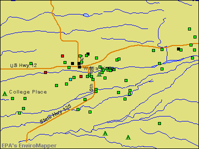
Points of interest:
Notable locations in Walla Walla: Walla Walla Country Club (A), Green Park Playground (B), Walla Walla Ranger Station (C), Washington State Penitentiary (D), Walla Walla County Fire District 4 Station 43 (E), Walla Walla Fire Department and Ambulance (F). Display/hide their locations on the map
Shopping Centers: Eastgate Shopping Center (1), Southgate Shopping Center (2), Plaza Shopping Center (3), Eastgate Mall (4). Display/hide their locations on the map
Main business address in Walla Walla include: BANNER CORP (A), KEY TECHNOLOGY INC (B). Display/hide their locations on the map
Cemeteries: Fort Walla Walla Military Cemetery (1), Mountain View Cemetery (2). Display/hide their locations on the map
Creeks: Bryant Creek (A), Titus Creek (B). Display/hide their locations on the map
Parks in Walla Walla include: Wildwood Park (1), Fort Walla Walla Park (2), Jefferson Park (3), Lions Park (4), Borleske Stadium (5), Tietan Park (6), Pioneer Park (7). Display/hide their locations on the map
Tourist attractions: Childrens Museum of Walla Walla (77 Wainwright Drive) (1), Kirkman House Museum (214 North Colville Street) (2), Historical Architecture Development Inc (Museums; 214 North Colville Street) (3). Display/hide their approximate locations on the map
Hotels: A & H Motel (2599 East Isaacs Avenue) (1), Inn at Blackberry Creek (1126 Pleasant Street) (2), McFeely Hotel (129 West Alder Street) (3), La Quinta Inn Walla Walla (520 North 2nd Avenue) (4), Best Western Walla Walla (7 East Oak Street) (5), Budget Inn (305 North 2nd Avenue) (6), Marcus Whitman Hotel & Conference Center (6 East Rose Street) (7), Howard Johnson (325 E Main Street) (8), City Center Motel (627 West Main Street) (9). Display/hide their approximate locations on the map
Birthplace of: Adam West - (born 1928), actor, Jonathan M. Wainwright (general) - Army Medal of Honor recipient, Walt Minnick - Politician, Bill Schelly - Writer, Burl Barer - Historian, Connor Trinneer - Stage, Dudley Wright Knox - Soilder, Eric O'Flaherty - Baseball player, Ferris Webster - Film editor, Hamza Yusuf - Islamic scholar.
Drinking water stations with addresses in Walla Walla and their reported violations in the past:
BLALOCK ORCHARD DIST 10 (Population served: 250, Groundwater):Past monitoring violations:DIXIE WATER ASSOCIATION (Population served: 240, Groundwater):
- 26 regular monitoring violations
Past health violations:BLALOCK ORCHARDS DIST 12 (Address: 1076 Newtown Road , Population served: 205, Groundwater):Past monitoring violations:
- MCL, Monthly (TCR) - In JUL-2005, Contaminant: Coliform
- One regular monitoring violation
Past monitoring violations:KPS GAS & GROCER (Population served: 104, Groundwater):
- 2 routine major monitoring violations
Past monitoring violations:COTTONWOOD GLEN WATER ASSN (Address: 3351 Ranch Rd , Population served: 65, Groundwater):
- 4 routine major monitoring violations
- 3 regular monitoring violations
Past monitoring violations:OASIS, THE (Serves OR, Population served: 50, Groundwater):
- Follow-up Or Routine LCR Tap M/R - In JAN-01-2006, Contaminant: Lead and Copper Rule. Follow-up actions: St Compliance achieved (DEC-31-2006)
Past monitoring violations:HIWAY TRAILER COURT (Population served: 18, Groundwater):
- 5 routine major monitoring violations
- One minor monitoring violation
- 2 regular monitoring violations
Past monitoring violations:
- One routine major monitoring violation
- 52 regular monitoring violations
| This city: | 2.4 people |
| Washington: | 2.5 people |
| This city: | 59.2% |
| Whole state: | 64.4% |
| This city: | 7.0% |
| Whole state: | 7.7% |
Likely homosexual households (counted as self-reported same-sex unmarried-partner households)
- Lesbian couples: 0.3% of all households
- Gay men: 0.2% of all households
People in group quarters in Walla Walla in 2010:
- 2,300 people in state prisons
- 911 people in college/university student housing
- 190 people in nursing facilities/skilled-nursing facilities
- 110 people in local jails and other municipal confinement facilities
- 61 people in emergency and transitional shelters (with sleeping facilities) for people experiencing homelessness
- 50 people in other noninstitutional facilities
- 29 people in group homes intended for adults
People in group quarters in Walla Walla in 2000:
- 2,364 people in state prisons
- 875 people in college dormitories (includes college quarters off campus)
- 373 people in nursing homes
- 104 people in other noninstitutional group quarters
- 85 people in local jails and other confinement facilities (including police lockups)
- 21 people in other group homes
- 4 people in religious group quarters
- 3 people in mental (psychiatric) hospitals or wards
Banks with most branches in Walla Walla (2011 data):
- Baker-Boyer National Bank: Wheatland Village Branch, The Plaza Branch, Eastgate Branch, Walla Walla Valley Mobile Branch, at Second And Main Streets. Info updated 2006/11/03: Bank assets: $502.0 mil, Deposits: $437.2 mil, local headquarters, positive income, Commercial Lending Specialization, 9 total offices, Holding Company: Baker Boyer Bancorp
- Banner Bank: Walla Walla - Eastgate Branch, Walla Walla Main Branch, Walla Walla - Ninth Avenue Branch, at 10 South First Street. Info updated 2011/05/03: Bank assets: $4,048.2 mil, Deposits: $3,348.4 mil, local headquarters, positive income, Commercial Lending Specialization, 87 total offices, Holding Company: Banner Corporation
- AmericanWest Bank: Walla Walla Downtown Financial Cente at 30 West Main, branch established on 2001/07/01; Walla Walla Eastgate Financial Cente at 1850 E Isaacs Avenue, branch established on 1981/09/14. Info updated 2011/12/12: Bank assets: $2,274.6 mil, Deposits: $1,889.1 mil, headquarters in Spokane, WA, positive income, Commercial Lending Specialization, 76 total offices, Holding Company: Skbhc Holdings Llc
- Community Bank: Walla Walla Branch at 28 East Alder, branch established on 2002/12/09. Info updated 2006/11/03: Bank assets: $360.5 mil, Deposits: $317.3 mil, headquarters in Joseph, OR, positive income, Agricultural Specialization, 16 total offices, Holding Company: Community Bancshares, Inc.
- JPMorgan Chase Bank, National Association: Walla Walla at 101 W Alder St, branch established on 1990/02/23. Info updated 2011/11/10: Bank assets: $1,811,678.0 mil, Deposits: $1,190,738.0 mil, headquarters in Columbus, OH, positive income, International Specialization, 5577 total offices, Holding Company: Jpmorgan Chase & Co.
- U.S. Bank National Association: Walla Walla Branch at 22 East Alder, branch established on 1961/11/24. Info updated 2012/01/30: Bank assets: $330,470.8 mil, Deposits: $236,091.5 mil, headquarters in Cincinnati, OH, positive income, 3121 total offices, Holding Company: U.S. Bancorp
- Sterling Savings Bank: Walla Walla Branch at 2 East Main Street, branch established on 1981/01/01. Info updated 2012/03/21: Bank assets: $9,207.8 mil, Deposits: $6,454.1 mil, headquarters in Spokane, WA, positive income, Commercial Lending Specialization, 192 total offices, Holding Company: Sterling Financial Corporation
- Bank of America, National Association: Walla Walla Valley Branch at 111 West Main Street, branch established on 1939/09/20. Info updated 2009/11/18: Bank assets: $1,451,969.3 mil, Deposits: $1,077,176.8 mil, headquarters in Charlotte, NC, positive income, 5782 total offices, Holding Company: Bank Of America Corporation
- Columbia State Bank: Walla Walla Branch at 500 W Main Street, branch established on 2004/12/27. Info updated 2011/08/09: Bank assets: $4,785.2 mil, Deposits: $3,892.8 mil, headquarters in Tacoma, WA, positive income, Commercial Lending Specialization, 104 total offices, Holding Company: Columbia Banking System, Inc.
For population 15 years and over in Walla Walla:
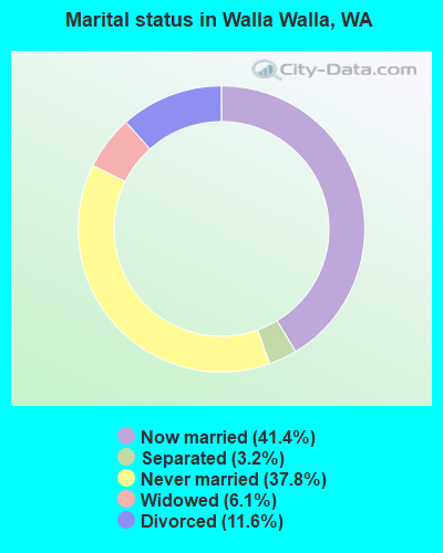
- Never married: 37.8%
- Now married: 41.4%
- Separated: 3.2%
- Widowed: 6.1%
- Divorced: 11.6%
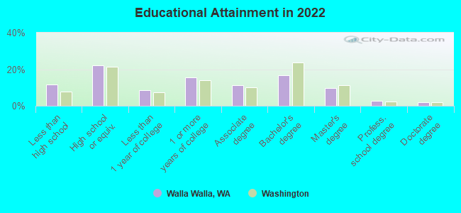
For population 25 years and over in Walla Walla:
- High school or higher: 87.8%
- Bachelor's degree or higher: 29.3%
- Graduate or professional degree: 13.1%
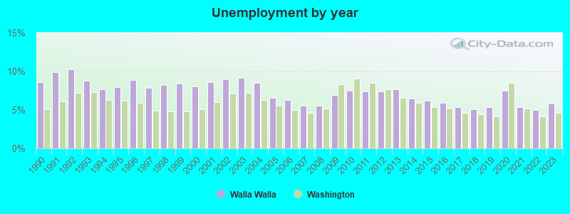
- Unemployed: 10.7%
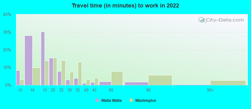
- Mean travel time to work (commute): 10.3 minutes
| Here: | 12.5 |
| Washington average: | 11.6 |
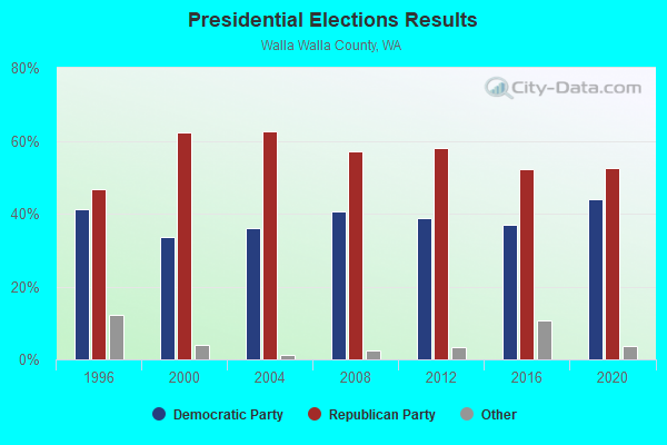
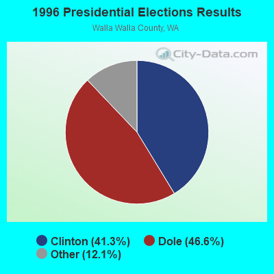
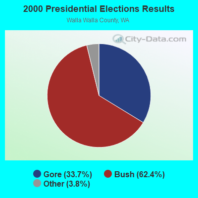
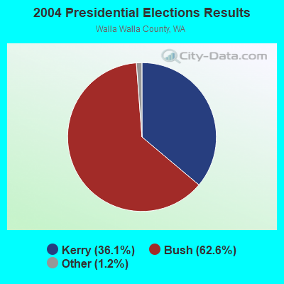
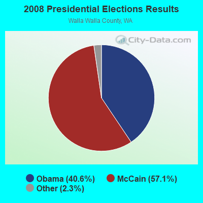
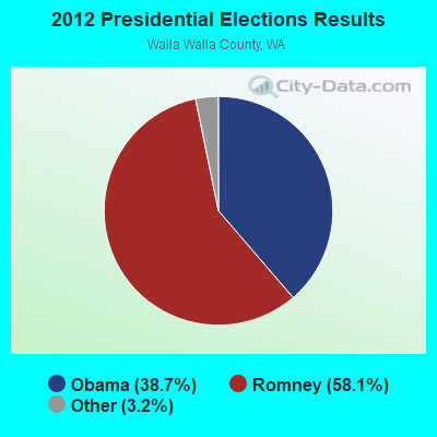
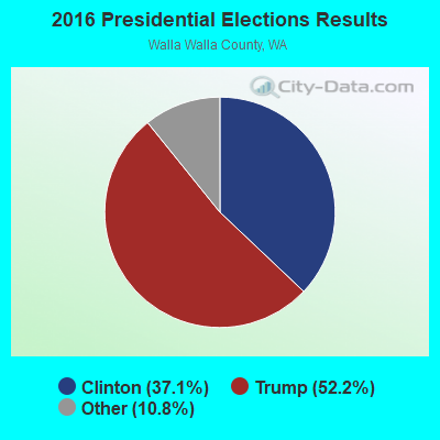
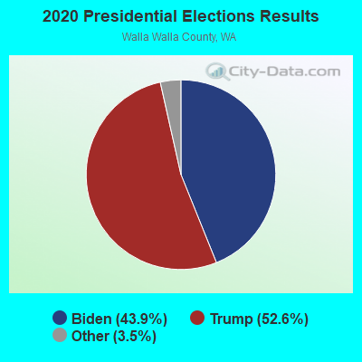
Graphs represent county-level data. Detailed 2008 Election Results
Religion statistics for Walla Walla, WA (based on Walla Walla County data)
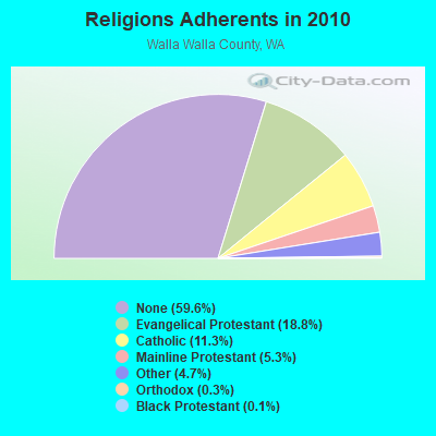
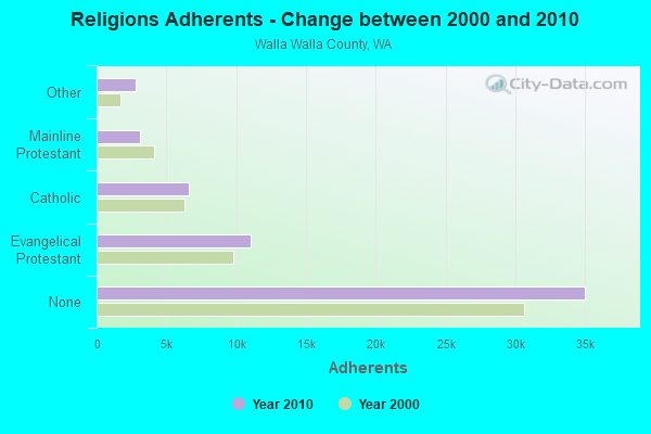
| Religion | Adherents | Congregations |
|---|---|---|
| Evangelical Protestant | 11,036 | 44 |
| Catholic | 6,630 | 5 |
| Mainline Protestant | 3,109 | 12 |
| Other | 2,761 | 12 |
| Orthodox | 160 | 1 |
| Black Protestant | 72 | 1 |
| None | 35,013 | - |
Food Environment Statistics:
| Walla Walla County: | 2.45 / 10,000 pop. |
| Washington: | 2.06 / 10,000 pop. |
| Walla Walla County: | 0.18 / 10,000 pop. |
| Washington: | 0.19 / 10,000 pop. |
| This county: | 0.70 / 10,000 pop. |
| State: | 1.18 / 10,000 pop. |
| Walla Walla County: | 1.93 / 10,000 pop. |
| Washington: | 2.67 / 10,000 pop. |
| Walla Walla County: | 5.95 / 10,000 pop. |
| State: | 8.26 / 10,000 pop. |
| This county: | 8.2% |
| Washington: | 7.7% |
| Here: | 24.8% |
| Washington: | 25.7% |
| Walla Walla County: | 12.8% |
| Washington: | 13.9% |
Health and Nutrition:
| Walla Walla: | 48.8% |
| Washington: | 49.9% |
| Here: | 46.6% |
| Washington: | 47.2% |
| Walla Walla: | 28.4 |
| Washington: | 28.4 |
| Walla Walla: | 21.0% |
| Washington: | 20.9% |
| Here: | 10.3% |
| Washington: | 10.5% |
| This city: | 6.8 |
| State: | 6.8 |
| Walla Walla: | 32.1% |
| Washington: | 32.8% |
| This city: | 56.1% |
| Washington: | 56.8% |
| This city: | 78.9% |
| Washington: | 79.4% |
More about Health and Nutrition of Walla Walla, WA Residents
| Local government employment and payroll (March 2022) | |||||
| Function | Full-time employees | Monthly full-time payroll | Average yearly full-time wage | Part-time employees | Monthly part-time payroll |
|---|---|---|---|---|---|
| Police Protection - Officers | 45 | $411,202 | $109,654 | 0 | $0 |
| Firefighters | 45 | $439,957 | $117,322 | 0 | $0 |
| Parks and Recreation | 32 | $228,336 | $85,626 | 1 | $1,945 |
| Police - Other | 30 | $171,891 | $68,756 | 1 | $4,802 |
| Streets and Highways | 28 | $203,749 | $87,321 | 0 | $0 |
| Solid Waste Management | 26 | $137,414 | $63,422 | 1 | $2,873 |
| Other Government Administration | 25 | $128,262 | $61,566 | 0 | $0 |
| Financial Administration | 23 | $176,499 | $92,086 | 0 | $0 |
| Water Supply | 19 | $115,602 | $73,012 | 0 | $0 |
| Other and Unallocable | 8 | $45,615 | $68,423 | 1 | $2,722 |
| Local Libraries | 7 | $45,989 | $78,838 | 8 | $20,962 |
| Sewerage | 6 | $26,260 | $52,520 | 0 | $0 |
| Judicial and Legal | 6 | $48,667 | $97,334 | 0 | $0 |
| Fire - Other | 3 | $21,923 | $87,692 | 0 | $0 |
| Housing and Community Development (Local) | 2 | $17,483 | $104,898 | 0 | $0 |
| Totals for Government | 305 | $2,218,849 | $87,299 | 12 | $33,304 |
Walla Walla government finances - Expenditure in 2018 (per resident):
- Construction - Regular Highways: $4,612,000 ($137.70)
Parks and Recreation: $1,688,000 ($50.40)
General - Other: $241,000 ($7.20)
Libraries: $8,000 ($0.24)
General Public Buildings: $7,000 ($0.21)
- Current Operations - Water Utilities: $8,876,000 ($265.02)
Police Protection: $8,759,000 ($261.53)
Solid Waste Management: $6,588,000 ($196.70)
General - Other: $5,902,000 ($176.22)
Local Fire Protection: $5,146,000 ($153.65)
Sewerage: $4,180,000 ($124.81)
Health - Other: $3,897,000 ($116.36)
Natural Resources - Other: $3,736,000 ($111.55)
Regular Highways: $3,472,000 ($103.67)
Financial Administration: $2,860,000 ($85.39)
Parks and Recreation: $1,669,000 ($49.83)
Libraries: $1,242,000 ($37.08)
Central Staff Services: $1,151,000 ($34.37)
Judicial and Legal Services: $1,137,000 ($33.95)
General Public Buildings: $600,000 ($17.91)
Miscellaneous Commercial Activities - Other: $514,000 ($15.35)
Housing and Community Development: $262,000 ($7.82)
Public Welfare - Other: $155,000 ($4.63)
Protective Inspection and Regulation - Other: $143,000 ($4.27)
- General - Interest on Debt: $2,132,000 ($63.66)
- Intergovernmental to Local - Other - Water Utilities: $2,132,000 ($63.66)
Other - Sewerage: $1,575,000 ($47.03)
Other - Solid Waste Management: $1,516,000 ($45.26)
Other - Natural Resources - Other: $406,000 ($12.12)
Other - Judicial and Legal Services: $267,000 ($7.97)
Other - Central Staff Services: $226,000 ($6.75)
Other - Correctional Institutions: $89,000 ($2.66)
Other - Health - Other: $67,000 ($2.00)
Other - Housing and Community Development: $52,000 ($1.55)
Other - General - Other: $4,000 ($0.12)
Other - Parks and Recreation: $2,000 ($0.06)
- Other Capital Outlay - Water Utilities: $2,395,000 ($71.51)
Solid Waste Management: $2,249,000 ($67.15)
Sewerage: $1,161,000 ($34.66)
General - Other: $710,000 ($21.20)
Natural Resources - Other: $439,000 ($13.11)
Police Protection: $25,000 ($0.75)
Regular Highways: $7,000 ($0.21)
- Total Salaries and Wages: $22,335,000 ($666.88)
- Water Utilities - Interest on Debt: $647,000 ($19.32)
Walla Walla government finances - Revenue in 2018 (per resident):
- Charges - Sewerage: $13,989,000 ($417.68)
Solid Waste Management: $11,618,000 ($346.89)
Other: $5,375,000 ($160.49)
Parks and Recreation: $541,000 ($16.15)
Miscellaneous Commercial Activities: $352,000 ($10.51)
Regular Highways: $227,000 ($6.78)
- Federal Intergovernmental - Housing and Community Development: $260,000 ($7.76)
Other: $94,000 ($2.81)
- Local Intergovernmental - Other: $1,811,000 ($54.07)
- Miscellaneous - Special Assessments: $1,705,000 ($50.91)
General Revenue - Other: $1,147,000 ($34.25)
Donations From Private Sources: $802,000 ($23.95)
Rents: $242,000 ($7.23)
Fines and Forfeits: $183,000 ($5.46)
Interest Earnings: $0 ($0.00)
- Revenue - Water Utilities: $13,348,000 ($398.54)
- State Intergovernmental - Highways: $2,730,000 ($81.51)
Other: $1,590,000 ($47.47)
General Local Government Support: $496,000 ($14.81)
Health and Hospitals: $1,000 ($0.03)
- Tax - General Sales and Gross Receipts: $7,868,000 ($234.92)
Public Utilities Sales: $7,677,000 ($229.22)
Property: $7,141,000 ($213.22)
Other Selective Sales: $973,000 ($29.05)
Other License: $846,000 ($25.26)
Other: $810,000 ($24.18)
Documentary and Stock Transfer: $453,000 ($13.53)
Occupation and Business License - Other: $297,000 ($8.87)
Amusements Sales: $72,000 ($2.15)
Walla Walla government finances - Debt in 2018 (per resident):
- Long Term Debt - Beginning Outstanding - Unspecified Public Purpose: $69,479,000 ($2074.50)
Outstanding Unspecified Public Purpose: $68,160,000 ($2035.11)
Retired Unspecified Public Purpose: $10,511,000 ($313.84)
Issue, Unspecified Public Purpose: $9,192,000 ($274.45)
- Short Term Debt Outstanding - Beginning: $276,000 ($8.24)
| Businesses in Walla Walla, WA | ||||
| Name | Count | Name | Count | |
|---|---|---|---|---|
| 7-Eleven | 1 | Little Caesars Pizza | 1 | |
| AT&T | 1 | Macy's | 1 | |
| Ace Hardware | 1 | MasterBrand Cabinets | 2 | |
| Albertsons | 1 | McDonald's | 2 | |
| Applebee's | 1 | Motherhood Maternity | 1 | |
| Arby's | 1 | Nike | 6 | |
| AutoZone | 1 | Nissan | 1 | |
| Baskin-Robbins | 2 | Pizza Hut | 1 | |
| Bed Bath & Beyond | 1 | Quiznos | 1 | |
| Best Western | 1 | RadioShack | 1 | |
| Budget Car Rental | 1 | Rite Aid | 1 | |
| Burger King | 1 | Safeway | 2 | |
| Chevrolet | 1 | Sears | 1 | |
| Circle K | 1 | Sprint Nextel | 1 | |
| Comfort Inn | 1 | Staples | 1 | |
| Curves | 1 | Starbucks | 5 | |
| Dairy Queen | 1 | Super 8 | 1 | |
| Domino's Pizza | 1 | T-Mobile | 1 | |
| FedEx | 4 | Taco Bell | 2 | |
| GNC | 1 | Toyota | 1 | |
| Goodwill | 6 | Travelodge | 1 | |
| H&R Block | 2 | True Value | 1 | |
| Holiday Inn | 1 | U-Haul | 1 | |
| Jones New York | 2 | UPS | 7 | |
| KFC | 1 | Vons | 2 | |
| Kmart | 1 | Wendy's | 1 | |
| La Quinta | 1 | YMCA | 1 | |
Strongest AM radio stations in Walla Walla:
- KUJ (1420 AM; 5 kW; WALLA WALLA, WA; Owner: ALEXANDRA COMMUNICATIONS)
- KTEL (1490 AM; 1 kW; WALLA WALLA, WA; Owner: WW2, L.L.C.)
- KGDC (1320 AM; 1 kW; WALLA WALLA, WA; Owner: BRIDGE BROADCASTING, INC.)
- KFLD (870 AM; 10 kW; PASCO, WA; Owner: CAPSTAR TX LIMITED PARTNERSHIP)
- KONA (610 AM; 5 kW; KENNEWICK-RICHLAND-P, WA; Owner: COMMONWEALTH LICENSE SUBSIDIARY, LLC)
- KTBI (810 AM; daytime; 50 kW; EPHRATA, WA; Owner: TACOMA BROADCASTERS, INCORPORATED)
- KQQQ (1150 AM; 25 kW; PULLMAN, WA; Owner: RADIO PALOUSE, INC.)
- KUMA (1290 AM; 5 kW; PENDLETON, OR; Owner: ROUND-UP RADIO, INC.)
- KGA (1510 AM; 50 kW; SPOKANE, WA; Owner: CITADEL BROADCASTING COMPANY)
- KALE (960 AM; 5 kW; RICHLAND, WA; Owner: NEW NORTHWEST BROADCASTERS, LLC)
- KMAX (840 AM; 10 kW; COLFAX, WA; Owner: PALOUSE COUNTRY, INC.)
- KWEI (1260 AM; 50 kW; WEISER, ID; Owner: TREASURE VALLEY BROADCASTING CO.)
- KPOJ (620 AM; 50 kW; PORTLAND, OR; Owner: CITICASTERS LICENSES, L.P.)
Strongest FM radio stations in Walla Walla:
- KHSS (100.7 FM; WALLA WALLA, WA; Owner: TWO HEARTS COMMUNICATIONS, LLC)
- KWCW (90.5 FM; WALLA WALLA, WA; Owner: ASWC RADIO COMMITTEE)
- KNLT (95.7 FM; WALLA WALLA, WA; Owner: NEW NORTHWEST BROADCASTERS, LLC)
- KGTS (91.3 FM; COLLEGE PLACE, WA; Owner: WALLA WALLA COLLEGE)
- KWWS (89.7 FM; WALLA WALLA, WA; Owner: WASHINGTON STATE UNIVERSITY)
- KRKL (93.3 FM; WALLA WALLA, WA; Owner: EDUCATIONAL MEDIA FOUNDATION)
- KOLW (97.9 FM; MILTON-FREEWATER, OR; Owner: CAPSTAR TX LIMITED PARTNERSHIP)
- KUJ-FM (99.1 FM; WALLA WALLA, WA; Owner: ALEXANDRA COMMUNICATIONS)
- KZZM (101.9 FM; WESTON, OR; Owner: BUTTERFIELD BROADCASTING CORPORATION)
- KZHR (92.5 FM; DAYTON, WA; Owner: COMMONWEALTH LICENSE SUBSIDIARY, LLC)
- KLRF (88.5 FM; MILTON-FREEWATER, OR; Owner: LIFETALK RADIO, INC.)
- KWHT (103.5 FM; PENDLETON, OR; Owner: KSRV, INC.)
- KUBQ (98.7 FM; LA GRANDE, OR; Owner: GRANDE RADIO, INC.)
- KONA-FM (105.3 FM; KENNEWICK, WA; Owner: COMMONWEALTH LICENSE SUBSIDIARY, LLC)
- KXRX (97.1 FM; WALLA WALLA, WA; Owner: CAPSTAR TX LIMITED PARTNERSHIP)
- KUMA-FM (107.7 FM; PENDLETON, OR; Owner: ROUND-UP RADIO, INC.)
- KIOK (94.9 FM; RICHLAND, WA; Owner: NEW NORTHWEST BROADCASTERS, LLC)
- KEYW (98.3 FM; PASCO, WA; Owner: CAPSTAR TX LIMITED PARTNERSHIP)
- K261CG (100.1 FM; PASCO, WA; Owner: NORTHWEST CHICANO RADIO NETWORK)
- KFAE-FM (89.1 FM; RICHLAND, WA; Owner: WASHINGTON STATE UNIVERSITY)
TV broadcast stations around Walla Walla:
- K28FT (Channel 28; WALLA WALLA, WA; Owner: BLUE MOUNTAIN BROADCASTING ASSOCIATION)
- K36EW (Channel 36; COLLEGE PLACE, WA; Owner: BLUE MOUNTAIN BROADCASTING ASSOCIATION)
- KAZW-TV (Channel 9; WALLA WALLA, WA; Owner: CASA OF WASHINGTON, LLC)
- K33EJ (Channel 33; WALLA WALLA, WA; Owner: THREE ANGELS BROADCASTING NETWORK, INC.)
- K14HT (Channel 14; WALLA WALLA, ETC., WA; Owner: APPLE VALLEY BROADCASTING, INC.)
- KORX-CA (Channel 16; PENDLETON, OR; Owner: WATCHTV, INC.)
Medal of Honor Recipients
Medal of Honor Recipient born in Walla Walla: Jonathan M. Wainwright.
- National Bridge Inventory (NBI) Statistics
- 49Number of bridges
- 472ft / 144mTotal length
- $151,451,000Total costs
- 217,410Total average daily traffic
- 18,937Total average daily truck traffic
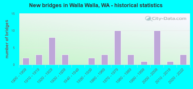
- New bridges - historical statistics
- 21900-1909
- 31910-1919
- 81920-1929
- 31930-1939
- 21950-1959
- 31960-1969
- 101970-1979
- 31980-1989
- 11990-1999
- 102000-2009
- 12010-2019
- 32020-2022
FCC Registered Antenna Towers: 185 (See the full list of FCC Registered Antenna Towers)
FCC Registered Commercial Land Mobile Towers: 2 (See the full list of FCC Registered Commercial Land Mobile Towers in Walla Walla, WA)
FCC Registered Private Land Mobile Towers: 3 (See the full list of FCC Registered Private Land Mobile Towers)
FCC Registered Broadcast Land Mobile Towers: 59 (See the full list of FCC Registered Broadcast Land Mobile Towers)
FCC Registered Microwave Towers: 62 (See the full list of FCC Registered Microwave Towers in this town)
FCC Registered Paging Towers: 10 (See the full list of FCC Registered Paging Towers)
FCC Registered Maritime Coast & Aviation Ground Towers: 2 (See the full list of FCC Registered Maritime Coast & Aviation Ground Towers)
FCC Registered Amateur Radio Licenses: 385 (See the full list of FCC Registered Amateur Radio Licenses in Walla Walla)
FAA Registered Aircraft Manufacturers and Dealers: 1 (See the full list of FAA Registered Manufacturers and Dealers in Walla Walla)
FAA Registered Aircraft: 83 (See the full list of FAA Registered Aircraft)
2002 - 2018 National Fire Incident Reporting System (NFIRS) incidents
- Fire incident types reported to NFIRS in Walla Walla, WA
- 95143.0%Outside Fires
- 83437.7%Structure Fires
- 34115.4%Mobile Property/Vehicle Fires
- 843.8%Other
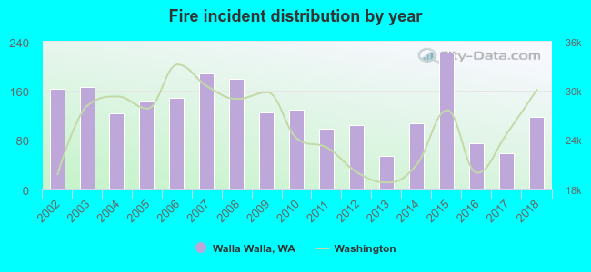 Based on the data from the years 2002 - 2018 the average number of fires per year is 130. The highest number of fire incidents - 222 took place in 2015, and the least - 55 in 2013. The data has a declining trend.
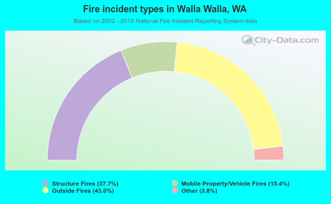 When looking into fire subcategories, the most reports belonged to: Outside Fires (43.0%), and Structure Fires (37.7%).
Fire-safe hotels and motels in Walla Walla, Washington:
- Quality Inn & Suites, 520 N Second Ave, Walla Walla, Washington 99362 , Phone: (509) 525-2522, Fax: (509) 522-2565
- Red Lion Inn & Suites, 325 E Main St, Walla Walla, Washington 99362 , Phone: (509) 529-4360, Fax: (509) 529-7463
- Hampton Inn & Suites - Walla Walla, 1531 Kelly Pl, Walla Walla, Washington 99362 , Phone: (509) 525-1398, Fax: (509) 525-1498
- Comfort Inn & Suites, 1419 Pine St, Walla Walla, Washington 99362 , Phone: (509) 522-3500, Fax: (509) 522-3501
- Walla Walla Hospitality, LLC Dba Courtyard By Marriot Walla Walla, 550 W Rose, Walla Walla, Washington 99362 , Phone: (509) 876-8100, Fax: (509) 876-8101
- Nageshwar Motel, Inc dba La Quinta Inn & Suites, 776 Silverstone Dr, Walla walla, Washington 99362 , Phone: (509) 394-8815
- comfort Inn & suites, 1419 W Pine St, Walla walla, Washington 99362 , Phone: (509) 522-3500, Fax: (509) 522-3501
- Holiday Inn Express, 1433 W Pine St, Walla Walla, Washington 99362 , Phone: (509) 525-6200, Fax: (509) 525-6210
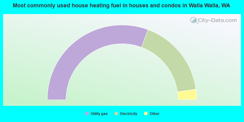
- 61.4%Utility gas
- 34.2%Electricity
- 1.7%Bottled, tank, or LP gas
- 1.7%Wood
- 0.6%Fuel oil, kerosene, etc.
- 0.3%Solar energy
- 0.2%Other fuel
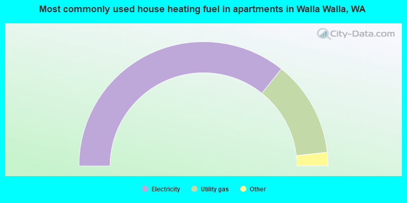
- 71.5%Electricity
- 25.0%Utility gas
- 1.5%Bottled, tank, or LP gas
- 1.1%No fuel used
- 0.3%Fuel oil, kerosene, etc.
- 0.3%Coal or coke
- 0.2%Wood
Walla Walla compared to Washington state average:
- Median household income below state average.
- Median house value below state average.
- Hispanic race population percentage above state average.
- Length of stay since moving in significantly above state average.
- House age above state average.
- Institutionalized population percentage significantly above state average.

|
|
Total of 108 patent applications in 2008-2024.