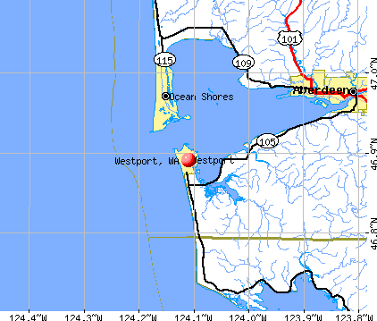
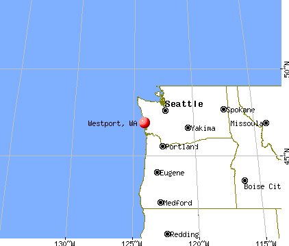
Westport, Washington
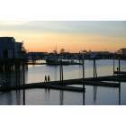
Westport: Sunset on the boardwalk in Westport Washington
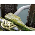
Westport: Knotword, Westport Marina
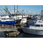
Westport: Fishing boats at rest in Westport Marina

Westport: Finding Treasures on the Beach at Westport
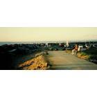
Westport: Westport Dunes
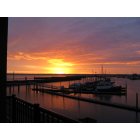
Westport: Sunrise over Westport Marina 1-1-12
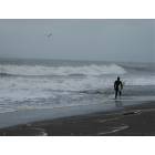
Westport: Surf's up in Half Moon Bay, Westport
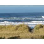
Westport: The Beach in Westport
- add
your
Submit your own pictures of this city and show them to the world
- OSM Map
- General Map
- Google Map
- MSN Map
Population change since 2000: +6.0%
 |
| Males: 1,059 | |
| Females: 1,206 |
| Median resident age: | 40.2 years |
| Washington median age: | 38.4 years |
Zip codes: 98595.
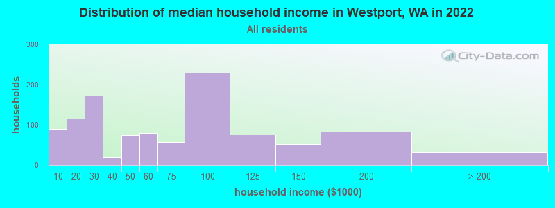
| Westport: | $57,409 |
| WA: | $91,306 |
Estimated per capita income in 2022: $32,529 (it was $17,362 in 2000)
Westport city income, earnings, and wages data
Estimated median house or condo value in 2022: $258,619 (it was $98,400 in 2000)
| Westport: | $258,619 |
| WA: | $569,500 |
Mean prices in 2022: all housing units: $274,506; detached houses: $297,323; townhouses or other attached units: $218,689; in 2-unit structures: $252,387; in 5-or-more-unit structures: $250,787; mobile homes: $122,211; occupied boats, rvs, vans, etc.: $215,521
Median gross rent in 2022: $777.
(20.1% for White Non-Hispanic residents, 100.0% for Black residents, 35.4% for Hispanic or Latino residents, 48.4% for other race residents, 83.8% for two or more races residents)
Detailed information about poverty and poor residents in Westport, WA


Compare current foreclosures near Westport, WA:
| Photo | Address | Area | Beds / Baths | Price | Details |
|---|---|---|---|---|---|

|
#1
2nd St N
Westport, WA 98595
|
- sq. feet
|
- baths - beds |
show details | |

|
#2
Chenault Ave
Hoquiam, WA 98550
|
- sq. feet
|
1 baths 3 beds |
show details | |

|
#3
Pioneer Blvd
Aberdeen, WA 98520
|
1,732 sq. feet
|
1 baths 3 beds |
show details | |

|
#4
W 5th St
Aberdeen, WA 98520
|
2,010 sq. feet
|
2 baths 3 beds |
show details | |

|
#5
W 5th St
Aberdeen, WA 98520
|
- sq. feet
|
1 baths 4 beds |
show details | |

|
#6
Pacific Ave
Hoquiam, WA 98550
|
1,300 sq. feet
|
1 baths 3 beds |
show details | |

|
#7
Cherry St
Hoquiam, WA 98550
|
- sq. feet
|
1 baths 2 beds |
show details | |

|
#8
Sumner Ave
Hoquiam, WA 98550
|
1,714 sq. feet
|
2 baths 4 beds |
show details | |

|
#9
E Scott St
Aberdeen, WA 98520
|
1,356 sq. feet
|
2 baths 3 beds |
show details | |

|
#10
Monroe St
Hoquiam, WA 98550
|
- sq. feet
|
2 baths 3 beds |
show details |
| Photo | Address | Area | Beds / Baths | Price | Details |
|---|---|---|---|---|---|

|
#11
W 2nd St
Aberdeen, WA 98520
|
- sq. feet
|
1 baths 2 beds |
show details | |

|
#12
30th St
Hoquiam, WA 98550
|
- sq. feet
|
1 baths 2 beds |
show details | |

|
#13
Pacific Ave
Hoquiam, WA 98550
|
- sq. feet
|
1 baths 2 beds |
show details | |

|
#14
N I St
Aberdeen, WA 98520
|
- sq. feet
|
2 baths 3 beds |
show details | |

|
#15
N Michigan St
Aberdeen, WA 98520
|
1,416 sq. feet
|
- baths - beds |
show details | |

|
#16
Wheeler Ave
Hoquiam, WA 98550
|
- sq. feet
|
1 baths 2 beds |
show details | |

|
#17
Emerson Ave
Hoquiam, WA 98550
|
- sq. feet
|
1 baths 2 beds |
show details | |

|
#18
Maple St
Hoquiam, WA 98550
|
1,646 sq. feet
|
- baths - beds |
show details | |

|
#19
N C St
Aberdeen, WA 98520
|
- sq. feet
|
- baths - beds |
show details | |

|
#20
E 1st St Apt 201
Aberdeen, WA 98520
|
- sq. feet
|
- baths - beds |
show details |
| Photo | Address | Area | Beds / Baths | Price | Details |
|---|---|---|---|---|---|

|
#21
E Wishkah St # 115
Aberdeen, WA 98520
|
- sq. feet
|
- baths - beds |
show details | |

|
#22
E 4th St # 3
Aberdeen, WA 98520
|
- sq. feet
|
- baths - beds |
show details | |

|
#23
Mcclellan St
Aberdeen, WA 98520
|
- sq. feet
|
- baths - beds |
show details | |

|
#24
W 2nd St
Aberdeen, WA 98520
|
- sq. feet
|
- baths - beds |
show details | |

|
#25
N Bel Air Loop SW
Ocean Shores, WA 98569
|
- sq. feet
|
- baths - beds |
show details | |

|
#26
Rustemeyer Rd, Trlr 4
Aberdeen, WA 98520
|
- sq. feet
|
- baths - beds |
show details | |

|
#27
Pacific Blvd NW
Ocean Shores, WA 98569
|
- sq. feet
|
- baths - beds |
show details | |

|
#28
Emerson Ave
Tokeland, WA 98590
|
1,742 sq. feet
|
- baths - beds |
show details | |

|
#29
Pt Brown Ave NE
Ocean Shores, WA 98569
|
- sq. feet
|
- baths - beds |
show details | |

|
#30
Constantine Way
Aberdeen, WA 98520
|
- sq. feet
|
- baths - beds |
show details |
| Photo | Address | Area | Beds / Baths | Price | Details |
|---|---|---|---|---|---|

|
#31
Miller Ct NE
Ocean Shores, WA 98569
|
- sq. feet
|
- baths - beds |
show details | |

|
#32
Ocosta Myrtle St
Aberdeen, WA 98520
|
- sq. feet
|
- baths - beds |
show details | |

|
#33
Cygnus St SW
Ocean Shores, WA 98569
|
- sq. feet
|
- baths - beds |
show details | |

|
#34
Beacon Hill Dr
Hoquiam, WA 98550
|
- sq. feet
|
- baths - beds |
show details | |

|
#35
W Wishkah St
Aberdeen, WA 98520
|
- sq. feet
|
- baths - beds |
show details | |

|
#36
Tingstrom Ln, # 531
Grayland, WA 98547
|
- sq. feet
|
- baths - beds |
show details | |

|
#37
S Mill St
Aberdeen, WA 98520
|
- sq. feet
|
- baths - beds |
show details | |

|
#38
Bayview Ln
Hoquiam, WA 98550
|
- sq. feet
|
- baths - beds |
show details | |

|
#39
Ensign Ave NW
Ocean Shores, WA 98569
|
- sq. feet
|
- baths - beds |
show details | |

|
#40
Burleigh Ave
Aberdeen, WA 98520
|
- sq. feet
|
- baths - beds |
show details |
| Photo | Address | Area | Beds / Baths | Price | Details |
|---|---|---|---|---|---|

|
#41
Westerly Dr
Aberdeen, WA 98520
|
- sq. feet
|
- baths - beds |
show details | |

|
#42
Wooding St
Aberdeen, WA 98520
|
- sq. feet
|
- baths - beds |
show details | |

|
#43
E Ocean Shores Blvd SW
Ocean Shores, WA 98569
|
- sq. feet
|
- baths - beds |
show details | |

|
#44
N L St
Aberdeen, WA 98520
|
- sq. feet
|
- baths - beds |
show details | |

|
#45
W Market St
Aberdeen, WA 98520
|
- sq. feet
|
- baths - beds |
show details | |

|
#46
E 10th St
Aberdeen, WA 98520
|
- sq. feet
|
- baths - beds |
show details | |

|
Check over 1 million property listings on Foreclosure.com!
|
browse all offers | |||


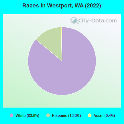
- 2,13383.9%White alone
- 33713.3%Hispanic
- 90.4%Asian alone
- 10.04%Black alone
- 10.04%Two or more races
Races in Westport detailed stats: ancestries, foreign born residents, place of birth
According to our research of Washington and other state lists, there were 4 registered sex offenders living in Westport, Washington as of April 27, 2024.
The ratio of all residents to sex offenders in Westport is 547 to 1.
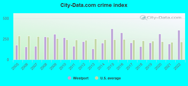
Type |
2009 |
2010 |
2011 |
2012 |
2013 |
2014 |
2015 |
2016 |
2017 |
2018 |
2019 |
2020 |
2021 |
2022 |
|---|---|---|---|---|---|---|---|---|---|---|---|---|---|---|
| Murders (per 100,000) | 0 (0.0) | 0 (0.0) | 0 (0.0) | 0 (0.0) | 0 (0.0) | 0 (0.0) | 0 (0.0) | 0 (0.0) | 0 (0.0) | 0 (0.0) | 0 (0.0) | 0 (0.0) | 0 (0.0) | 0 (0.0) |
| Rapes (per 100,000) | 3 (114.0) | 0 (0.0) | 0 (0.0) | 0 (0.0) | 0 (0.0) | 0 (0.0) | 2 (99.9) | 1 (49.7) | 0 (0.0) | 1 (48.9) | 0 (0.0) | 3 (142.7) | 1 (47.1) | 2 (87.7) |
| Robberies (per 100,000) | 1 (38.0) | 0 (0.0) | 0 (0.0) | 0 (0.0) | 0 (0.0) | 0 (0.0) | 0 (0.0) | 0 (0.0) | 0 (0.0) | 0 (0.0) | 0 (0.0) | 1 (47.6) | 0 (0.0) | 1 (43.9) |
| Assaults (per 100,000) | 2 (76.0) | 1 (47.6) | 0 (0.0) | 0 (0.0) | 0 (0.0) | 1 (49.6) | 3 (149.9) | 1 (49.7) | 1 (49.3) | 2 (97.7) | 7 (336.5) | 0 (0.0) | 2 (94.2) | 3 (131.6) |
| Burglaries (per 100,000) | 21 (798.2) | 43 (2,049) | 17 (797.4) | 29 (1,372) | 12 (587.7) | 17 (842.8) | 20 (999.0) | 23 (1,144) | 11 (542.7) | 13 (635.1) | 8 (384.6) | 9 (428.2) | 8 (376.8) | 27 (1,184) |
| Thefts (per 100,000) | 85 (3,231) | 50 (2,382) | 53 (2,486) | 57 (2,698) | 36 (1,763) | 58 (2,876) | 92 (4,595) | 88 (4,376) | 74 (3,651) | 26 (1,270) | 55 (2,644) | 70 (3,330) | 56 (2,638) | 79 (3,465) |
| Auto thefts (per 100,000) | 2 (76.0) | 5 (238.2) | 2 (93.8) | 4 (189.3) | 5 (244.9) | 4 (198.3) | 3 (149.9) | 5 (248.6) | 3 (148.0) | 1 (48.9) | 1 (48.1) | 6 (285.4) | 1 (47.1) | 7 (307.0) |
| Arson (per 100,000) | 1 (38.0) | 1 (47.6) | 0 (0.0) | 2 (94.7) | 0 (0.0) | 0 (0.0) | 0 (0.0) | 3 (149.2) | 0 (0.0) | 0 (0.0) | 0 (0.0) | 2 (95.1) | 1 (47.1) | 0 (0.0) |
| City-Data.com crime index | 309.0 | 267.3 | 162.8 | 219.1 | 131.2 | 199.8 | 375.6 | 324.7 | 205.7 | 157.8 | 203.8 | 314.5 | 192.2 | 355.7 |
The City-Data.com crime index weighs serious crimes and violent crimes more heavily. Higher means more crime, U.S. average is 246.1. It adjusts for the number of visitors and daily workers commuting into cities.
Crime rate in Westport detailed stats: murders, rapes, robberies, assaults, burglaries, thefts, arson
Full-time law enforcement employees in 2021, including police officers: 8 (7 officers - 6 male; 1 female).
| Officers per 1,000 residents here: | 3.30 |
| Washington average: | 1.35 |
 Recent articles from our blog. Our writers, many of them Ph.D. graduates or candidates, create easy-to-read articles on a wide variety of topics.

 | Westport or Port Angeles? (5 replies) |
| Ocean Shores joins forces to restore ferry service with Westport (4 replies) |
| Ocean Shores--good, bad and the ugly (107 replies) |
| Westport vs. Ocean Shores (15 replies) |
| Retiring to Ocean Shores (16 replies) |
| Do you live in one of the new Zoom Towns? (31 replies) |
Latest news from Westport, WA collected exclusively by city-data.com from local newspapers, TV, and radio stations
Ancestries: Irish (22.7%), German (11.6%), Dutch (8.7%), English (8.3%), Norwegian (7.0%), Swedish (6.0%).
Current Local Time: PST time zone
Incorporated in 1914
Elevation: 12 feet
Land area: 3.60 square miles.
Population density: 628 people per square mile (low).
95 residents are foreign born (2.0% Latin America, 0.7% Europe, 0.5% Asia, 0.5% North America).
| This city: | 3.7% |
| Washington: | 14.9% |
Median real estate property taxes paid for housing units with mortgages in 2022: $1,984 (0.7%)
Median real estate property taxes paid for housing units with no mortgage in 2022: $2,287 (1.2%)
Nearest city with pop. 50,000+: Lakewood, WA  (77.0 miles , pop. 58,211).
Nearest city with pop. 200,000+: Seattle, WA (97.7 miles , pop. 563,374).
Nearest city with pop. 1,000,000+: Los Angeles, CA (935.0 miles , pop. 3,694,820).
Nearest cities:
), ), Latitude: 46.89 N, Longitude: 124.11 W

Single-family new house construction building permits:
- 2022: 23 buildings, average cost: $242,000
- 2021: 15 buildings, average cost: $339,300
- 2020: 6 buildings, average cost: $201,500
- 2019: 10 buildings, average cost: $146,400
- 2018: 4 buildings, average cost: $271,000
- 2017: 3 buildings, average cost: $122,500
- 2015: 4 buildings, average cost: $134,800
- 2014: 1 building, cost: $105,800
- 2013: 1 building, cost: $187,300
- 2012: 2 buildings, average cost: $257,500
- 2011: 4 buildings, average cost: $160,300
- 2010: 4 buildings, average cost: $233,500
- 2009: 1 building, cost: $64,300
- 2008: 16 buildings, average cost: $132,000
- 2007: 51 buildings, average cost: $228,400
- 2006: 14 buildings, average cost: $136,800
- 2005: 11 buildings, average cost: $120,200
- 2004: 9 buildings, average cost: $120,200
- 2003: 15 buildings, average cost: $88,900
- 2002: 10 buildings, average cost: $93,600
- 2001: 5 buildings, average cost: $98,500
- 2000: 5 buildings, average cost: $88,300
- 1999: 7 buildings, average cost: $101,300
- 1998: 6 buildings, average cost: $83,100
- 1997: 6 buildings, average cost: $83,100
| Here: | 7.4% |
| Washington: | 4.6% |
- Accommodation & food services (14.4%)
- Agriculture, forestry, fishing & hunting (10.8%)
- Educational services (9.7%)
- Public administration (7.6%)
- Transportation equipment (7.1%)
- Health care (6.1%)
- Food (4.4%)
- Agriculture, forestry, fishing & hunting (18.2%)
- Transportation equipment (12.0%)
- Educational services (8.8%)
- Accommodation & food services (8.8%)
- Construction (6.9%)
- Public administration (6.0%)
- Food & beverage stores (4.7%)
- Accommodation & food services (21.2%)
- Educational services (10.9%)
- Health care (9.8%)
- Public administration (9.6%)
- Food (5.4%)
- Department & other general merchandise stores (4.1%)
- Other direct selling establishments (3.9%)
- Fishing, hunting, and forestry occupations (9.4%)
- Other management occupations, except farmers and farm managers (6.7%)
- Building and grounds cleaning and maintenance occupations (5.3%)
- Other production occupations, including supervisors (4.6%)
- Retail sales workers, except cashiers (4.0%)
- Electrical equipment mechanics and other installation, maintenance, and repair workers, including supervisors (3.3%)
- Other sales and related occupations, including supervisors (3.3%)
- Fishing, hunting, and forestry occupations (17.1%)
- Other production occupations, including supervisors (7.5%)
- Other management occupations, except farmers and farm managers (6.4%)
- Electrical equipment mechanics and other installation, maintenance, and repair workers, including supervisors (6.0%)
- Carpenters (4.3%)
- Other sales and related occupations, including supervisors (4.1%)
- Electricians (3.6%)
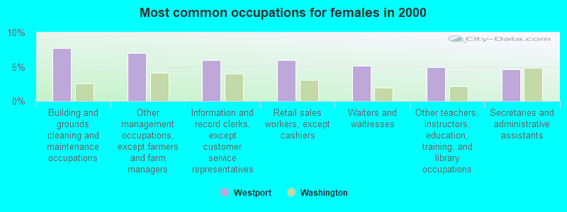
- Building and grounds cleaning and maintenance occupations (7.8%)
- Other management occupations, except farmers and farm managers (7.0%)
- Information and record clerks, except customer service representatives (5.9%)
- Retail sales workers, except cashiers (5.9%)
- Waiters and waitresses (5.2%)
- Other teachers, instructors, education, training, and library occupations (4.9%)
- Secretaries and administrative assistants (4.7%)
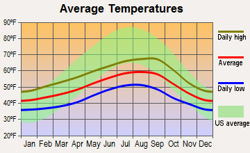
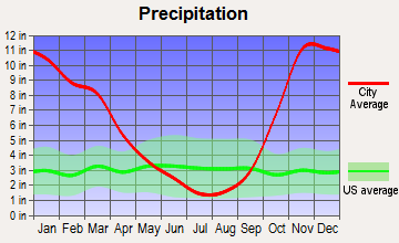
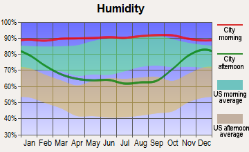
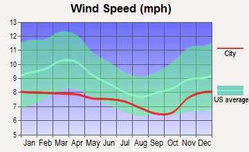
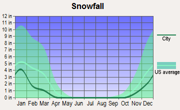
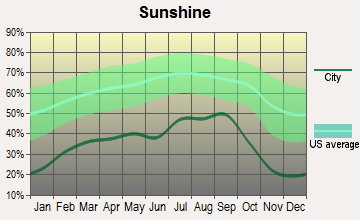
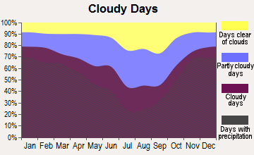
Average climate in Westport, Washington
Based on data reported by over 4,000 weather stations
|
|

(lower is better)
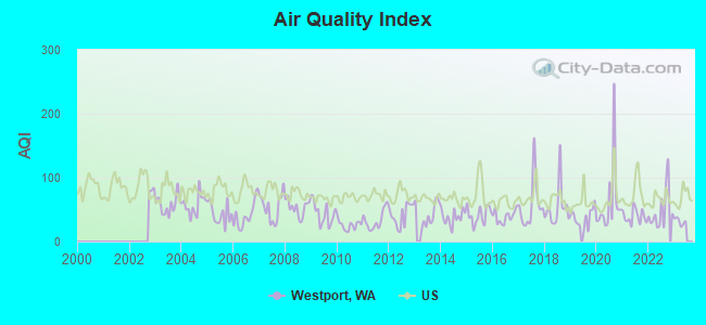
Air Quality Index (AQI) level in 2022 was 49.2. This is significantly better than average.
| City: | 49.2 |
| U.S.: | 72.6 |
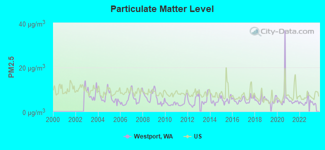
Particulate Matter (PM2.5) [µg/m3] level in 2022 was 4.44. This is significantly better than average. Closest monitor was 14.3 miles away from the city center.
| City: | 4.44 |
| U.S.: | 8.11 |
Earthquake activity:
Westport-area historical earthquake activity is significantly above Washington state average. It is 1200% greater than the overall U.S. average.On 4/13/1949 at 19:55:42, a magnitude 7.0 (7.0 UK, Class: Major, Intensity: VIII - XII) earthquake occurred 79.8 miles away from Westport center, causing $80,000,000 total damage
On 2/28/2001 at 18:54:32, a magnitude 6.8 (6.8 MD, Depth: 32.2 mi, Class: Strong, Intensity: VII - IX) earthquake occurred 67.6 miles away from Westport center
On 2/28/2001 at 18:54:32, a magnitude 6.8 (6.5 MB, 6.6 MS, 6.8 MW) earthquake occurred 73.5 miles away from the city center, causing $2,000,000,000 total damage and $305,000,000 insured losses
On 4/29/1965 at 15:28:43, a magnitude 6.6 (6.6 UK) earthquake occurred 88.7 miles away from the city center, causing $28,000,000 total damage
On 7/3/1999 at 01:43:54, a magnitude 5.8 (5.4 MB, 5.5 MS, 5.8 MW, 5.3 ME, Depth: 25.2 mi, Class: Moderate, Intensity: VI - VII) earthquake occurred 43.0 miles away from Westport center
On 1/31/1922 at 13:17:28, a magnitude 7.6 (7.6 UK) earthquake occurred 434.2 miles away from the city center
Magnitude types: body-wave magnitude (MB), duration magnitude (MD), energy magnitude (ME), surface-wave magnitude (MS), moment magnitude (MW)
Natural disasters:
The number of natural disasters in Grays Harbor County (28) is a lot greater than the US average (15).Major Disasters (Presidential) Declared: 25
Emergencies Declared: 1
Causes of natural disasters: Floods: 21, Storms: 15, Mudslides: 12, Landslides: 10, Winter Storms: 7, Winds: 4, Heavy Rains: 2, Snows: 2, Tornadoes: 2, Earthquake: 1, Hurricane: 1, Volcanic Eruption: 1, Other: 1 (Note: some incidents may be assigned to more than one category).
Hospitals and medical centers near Westport:
- HARBORS HOME HEALTH/HOSPICE (Home Health Center, about 13 miles away; HOQUIAM, WA)
- HOQUIAM HEALTHCARE, INC DBA PACIFIC CARE CENTER (Nursing Home, about 14 miles away; HOQUIAM, WA)
- FMC ABERDEEN (Dialysis Facility, about 14 miles away; ABERDEEN, WA)
- GRAYS HARBOR CONVALESCENT CENTER (Nursing Home, about 14 miles away; ABERDEEN, WA)
- GRAYS HARBOR HEALTH AND REHABILITATION CENTER (Nursing Home, about 14 miles away; ABERDEEN, WA)
- GRAYS HARBOR COMMUNITY HOSPITAL Acute Care Hospitals (about 14 miles away; ABERDEEN, WA)
- COMMUNITY HOSPITAL HOSPICE (Hospital, about 15 miles away; ABERDEEN, WA)
Airports located in Westport:
- Westport Airport (14S) (Runways: 1, Itinerant Ops: 500, Local Ops: 500)
Colleges/universities with over 2000 students nearest to Westport:
- The Evergreen State College (about 55 miles; Olympia, WA; Full-time enrollment: 4,613)
- Centralia College (about 56 miles; Centralia, WA; FT enrollment: 2,354)
- South Puget Sound Community College (about 57 miles; Olympia, WA; FT enrollment: 3,981)
- Pierce College at Fort Steilacoom (about 76 miles; Lakewood, WA; FT enrollment: 5,228)
- Lower Columbia College (about 77 miles; Longview, WA; FT enrollment: 2,595)
- Clover Park Technical College (about 79 miles; Lakewood, WA; FT enrollment: 4,185)
- Tacoma Community College (about 79 miles; Tacoma, WA; FT enrollment: 6,622)
Public high school in Westport:
- OCOSTA JUNIOR - SENIOR HIGH (Location: 2580 MONTESANO STREET SOUTH, Grades: 7-12)
Public elementary/middle school in Westport:
- OCOSTA ELEMENTARY SCHOOL (Location: 2580 MONTESANO STREET SOUTH, Grades: PK-6)
User-submitted facts and corrections:
- Strongest FM stations please add: KYAO (100.1 FM Ocean Shores - Ocean Shores Educational Media
Points of interest:
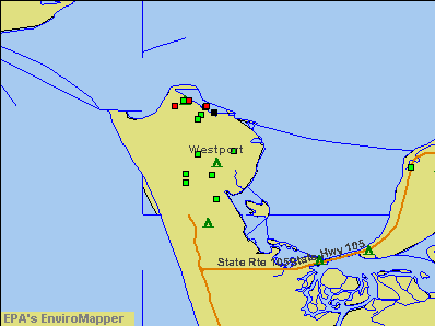
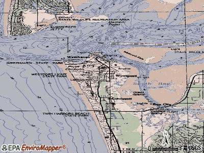
Notable locations in Westport: Westport Marina (A), Westport Wastewater Treatment Plant (B), Grays Harbor CG (C), South Beach Ambulance Service (D), City of Westport Fire Department (E), Westport City Hall (F), Westport Maritime Museum (G), Grays Harbor Lighthouse (H), Westport Timberland Library (I). Display/hide their locations on the map
Churches in Westport include: Saint Christopher Episcopal Church (A), Twin Harbor Baptist Church (B), Kingdom Hall of Jehovahs Witnesses (C). Display/hide their locations on the map
Parks in Westport include: Westhaven State Park (1), Westport Light State Park (2). Display/hide their locations on the map
Tourist attractions: Westport Aquarium (Aquariums; 321 East Harbor), Vacations By The Sea (Recreation Areas; 2662 W Ocean Ave), Cachalot Charters (Tours & Charters; 2511 Westhaven Drive).
Hotels: Holiday Motel (231 East Dock Street), COHO Charters Motel & RV Park of Westport Inc (2501 North Nyhus), Historic Glen Acres Bed & Breakfast (222 N Montesano St), Pacific Motel & RV Inc (330 South Forrest Street), Ocean Avenue Inn (275 West Ocean Avenue), Breakers Motel (971 South Montesano Street), Chateau Westport (710 West Hancock), Cranberry Motel (920 South Montesano Street), Mariners Cove Inn LLC (303 W Ocean Ave).
| This city: | 2.1 people |
| Washington: | 2.5 people |
| This city: | 52.8% |
| Whole state: | 64.4% |
| This city: | 9.8% |
| Whole state: | 7.7% |
Likely homosexual households (counted as self-reported same-sex unmarried-partner households)
- Lesbian couples: 0.6% of all households
- Gay men: 0.4% of all households
9 people in military barracks, etc. in 2000
Banks with branches in Westport (2011 data):
- Anchor Bank: 03 - Westport Branch at Montesano And Washington, branch established on 1907/01/01. Info updated 2011/04/05: Bank assets: $486.5 mil, Deposits: $352.2 mil, headquarters in Aberdeen, WA, negative income in the last year, Commercial Lending Specialization, 13 total offices, Holding Company: Anchor Bancorp, Inc.
- Bank of America, National Association: Westport Branch at 620 North Montesano Street, branch established on 1961/04/13. Info updated 2009/11/18: Bank assets: $1,451,969.3 mil, Deposits: $1,077,176.8 mil, headquarters in Charlotte, NC, positive income, 5782 total offices, Holding Company: Bank Of America Corporation
For population 15 years and over in Westport:
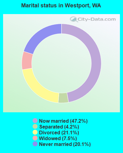
- Never married: 20.1%
- Now married: 47.2%
- Separated: 4.2%
- Widowed: 7.5%
- Divorced: 21.1%
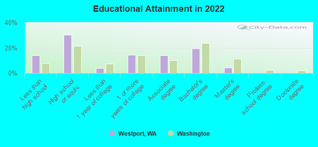
For population 25 years and over in Westport:
- High school or higher: 85.4%
- Bachelor's degree or higher: 19.2%
- Graduate or professional degree: 5.2%
- Unemployed: 7.7%
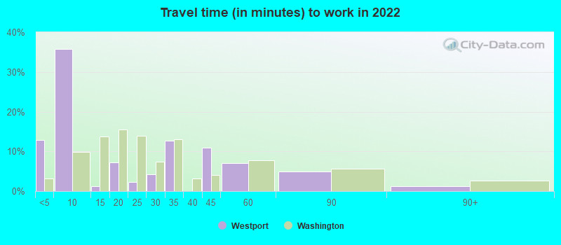
- Mean travel time to work (commute): 19.0 minutes
| Here: | 10.8 |
| Washington average: | 11.6 |
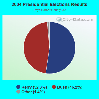
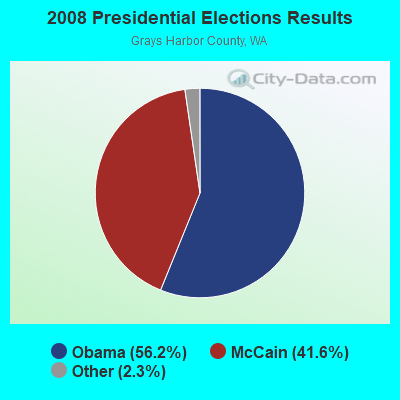

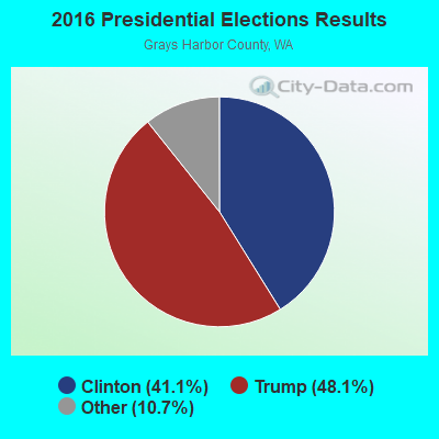
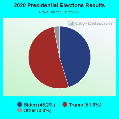
Graphs represent county-level data. Detailed 2008 Election Results
Religion statistics for Westport, WA (based on Grays Harbor County data)
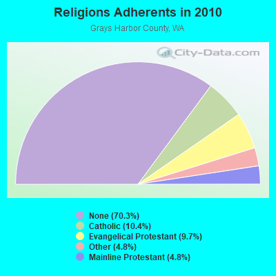
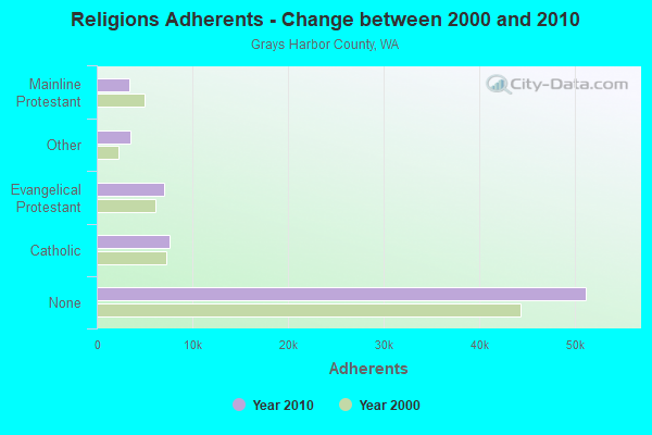
| Religion | Adherents | Congregations |
|---|---|---|
| Catholic | 7,602 | 8 |
| Evangelical Protestant | 7,083 | 58 |
| Other | 3,506 | 14 |
| Mainline Protestant | 3,459 | 25 |
| None | 51,147 | - |
Food Environment Statistics:
| Grays Harbor County: | 3.51 / 10,000 pop. |
| State: | 2.06 / 10,000 pop. |
| Here: | 2.95 / 10,000 pop. |
| Washington: | 1.18 / 10,000 pop. |
| This county: | 4.21 / 10,000 pop. |
| Washington: | 2.67 / 10,000 pop. |
| Grays Harbor County: | 8.99 / 10,000 pop. |
| State: | 8.26 / 10,000 pop. |
| Grays Harbor County: | 11.0% |
| Washington: | 7.7% |
| Grays Harbor County: | 33.8% |
| State: | 25.7% |
| Here: | 18.4% |
| Washington: | 13.9% |
Health and Nutrition:
| Here: | 49.5% |
| Washington: | 49.9% |
| Here: | 46.3% |
| Washington: | 47.2% |
| Westport: | 29.9 |
| State: | 28.4 |
| This city: | 22.5% |
| Washington: | 20.9% |
| Westport: | 19.2% |
| Washington: | 10.5% |
| This city: | 6.8 |
| Washington: | 6.8 |
| Westport: | 41.2% |
| Washington: | 32.8% |
| Westport: | 52.7% |
| Washington: | 56.8% |
| Westport: | 76.4% |
| Washington: | 79.4% |
More about Health and Nutrition of Westport, WA Residents
| Local government employment and payroll (March 2022) | |||||
| Function | Full-time employees | Monthly full-time payroll | Average yearly full-time wage | Part-time employees | Monthly part-time payroll |
|---|---|---|---|---|---|
| Police Protection - Officers | 7 | $50,215 | $86,083 | 0 | $0 |
| Streets and Highways | 4 | $26,363 | $79,089 | 1 | $1,638 |
| Sewerage | 4 | $26,389 | $79,167 | 0 | $0 |
| Water Supply | 4 | $26,992 | $80,976 | 0 | $0 |
| Financial Administration | 3 | $21,586 | $86,344 | 0 | $0 |
| Other Government Administration | 2 | $12,727 | $76,362 | 6 | $3,679 |
| Police - Other | 2 | $16,050 | $96,300 | 0 | $0 |
| Other and Unallocable | 1 | $6,613 | $79,356 | 0 | $0 |
| Judicial and Legal | 0 | $0 | 2 | $4,540 | |
| Totals for Government | 27 | $186,935 | $83,082 | 9 | $9,857 |
Westport government finances - Expenditure in 2017 (per resident):
- Construction - Regular Highways: $37,000 ($16.34)
Parking Facilities: $11,000 ($4.86)
- Current Operations - Water Utilities: $1,044,000 ($460.93)
Police Protection: $992,000 ($437.97)
Sewerage: $794,000 ($350.55)
Solid Waste Management: $681,000 ($300.66)
Health - Other: $649,000 ($286.53)
General - Other: $387,000 ($170.86)
Regular Highways: $375,000 ($165.56)
Local Fire Protection: $257,000 ($113.47)
Judicial and Legal Services: $176,000 ($77.70)
Financial Administration: $148,000 ($65.34)
General Public Buildings: $129,000 ($56.95)
Parks and Recreation: $107,000 ($47.24)
Protective Inspection and Regulation - Other: $96,000 ($42.38)
Central Staff Services: $87,000 ($38.41)
Air Transportation: $12,000 ($5.30)
Libraries: $6,000 ($2.65)
Parking Facilities: $3,000 ($1.32)
- General - Interest on Debt: $212,000 ($93.60)
- Intergovernmental to Local - Other - Solid Waste Management: $31,000 ($13.69)
Other - General - Other: $1,000 ($0.44)
- Other Capital Outlay - Sewerage: $112,000 ($49.45)
General - Other: $53,000 ($23.40)
Parks and Recreation: $39,000 ($17.22)
Water Utilities: $27,000 ($11.92)
Local Fire Protection: $23,000 ($10.15)
Regular Highways: $13,000 ($5.74)
Police Protection: $11,000 ($4.86)
- Total Salaries and Wages: $1,735,000 ($766.00)
- Water Utilities - Interest on Debt: $5,000 ($2.21)
Westport government finances - Revenue in 2017 (per resident):
- Charges - Sewerage: $1,173,000 ($517.88)
Solid Waste Management: $672,000 ($296.69)
Other: $171,000 ($75.50)
- Local Intergovernmental - Other: $3,000 ($1.32)
- Miscellaneous - General Revenue - Other: $242,000 ($106.84)
Fines and Forfeits: $61,000 ($26.93)
Donations From Private Sources: $49,000 ($21.63)
Rents: $42,000 ($18.54)
Sale of Property: $1,000 ($0.44)
Interest Earnings: $0 ($0.00)
- Revenue - Water Utilities: $1,232,000 ($543.93)
- State Intergovernmental - Other: $60,000 ($26.49)
Highways: $48,000 ($21.19)
General Local Government Support: $28,000 ($12.36)
Health and Hospitals: $1,000 ($0.44)
- Tax - Property: $1,267,000 ($559.38)
Occupation and Business License - Other: $685,000 ($302.43)
Public Utilities Sales: $634,000 ($279.91)
General Sales and Gross Receipts: $424,000 ($187.20)
Other Selective Sales: $314,000 ($138.63)
Other License: $30,000 ($13.25)
Documentary and Stock Transfer: $28,000 ($12.36)
Amusements Sales: $2,000 ($0.88)
Westport government finances - Debt in 2017 (per resident):
- Long Term Debt - Beginning Outstanding - Unspecified Public Purpose: $8,843,000 ($3904.19)
Outstanding Unspecified Public Purpose: $8,380,000 ($3699.78)
Retired Unspecified Public Purpose: $498,000 ($219.87)
Issue, Unspecified Public Purpose: $35,000 ($15.45)
Businesses in Westport, WA
- Ace Hardware: 1
- Subway: 1
Strongest AM radio stations in Westport:
- KXRO (1320 AM; 5 kW; ABERDEEN, WA; Owner: MCC RADIO, LLC)
- KIRO (710 AM; 50 kW; SEATTLE, WA; Owner: ENTERCOM SEATTLE LICENSE, LLC)
- KTTH (770 AM; 50 kW; SEATTLE, WA; Owner: ENTERCOM SEATTLE LICENSE, LLC)
- KGNW (820 AM; 50 kW; BURIEN-SEATTLE, WA; Owner: INSPIRATION MEDIA, INC.)
- KJR (950 AM; 50 kW; SEATTLE, WA)
- KOMO (1000 AM; 50 kW; SEATTLE, WA; Owner: FISHER BROADCASTING - SEATTLE RADIO, L.L.C.)
- KYCW (1090 AM; 50 kW; SEATTLE, WA; Owner: INFINITY RADIO SUBSIDIARY OPERATIONS INC.)
- KIXI (880 AM; 50 kW; MERCER ISLAND/SEATTL, WA; Owner: BELLEVUE RADIO, INC.)
- KPOJ (620 AM; 50 kW; PORTLAND, OR; Owner: CITICASTERS LICENSES, L.P.)
- KKOL (1300 AM; 50 kW; SEATTLE, WA; Owner: INSPIRATION MEDIA, INC.)
- KPAM (860 AM; 50 kW; TROUTDALE, OR; Owner: PAMPLIN BROADCASTING-OREGON, INC.)
- KWOK (1490 AM; 1 kW; HOQUIAM, WA; Owner: MCC RADIO, LLC)
- KXL (750 AM; 50 kW; PORTLAND, OR; Owner: ROSE CITY RADIO CORPORATION)
Strongest FM radio stations in Westport:
- KAYO-FM (99.3 FM; ELMA, WA; Owner: SOUTH SOUND BROADCASTING, LLC)
- KFMY (97.7 FM; RAYMOND, WA; Owner: SOUTH SOUND BROADCASTING, LLC)
- KJET (105.7 FM; SOUTH BEND, WA; Owner: JODESHA BROADCASTING, INC.)
- KXXK (95.3 FM; HOQUIAM, WA; Owner: MCC RADIO, LLC)
- KMNT (102.9 FM; CENTRALIA, WA; Owner: CITICASTERS LICENSES, L.P.)
- K216DH (91.1 FM; CATHLAMET, WA; Owner: TILLICUM FOUNDATION)
- KDUX-FM (104.7 FM; ABERDEEN, WA; Owner: MCC RADIO, LLC)
- K205EN (88.9 FM; ABERDEEN, WA; Owner: CALVARY CHAPEL OF TWIN FALLS, INC.)
- K207DB (89.3 FM; ABERDEEN, WA; Owner: EDUCATIONAL MEDIA FOUNDATION)
- KMUN (91.9 FM; ASTORIA, OR; Owner: TILLICUM FOUNDATION)
- KGY-FM (96.9 FM; MCCLEARY, WA; Owner: KGY, INC.)
- KWYA (89.7 FM; ASTORIA, OR; Owner: WAY-FM MEDIA GROUP, INC.)
- KSWW (102.1 FM; MONTESANO, WA; Owner: JODESHA BROADCASTING, INC.)
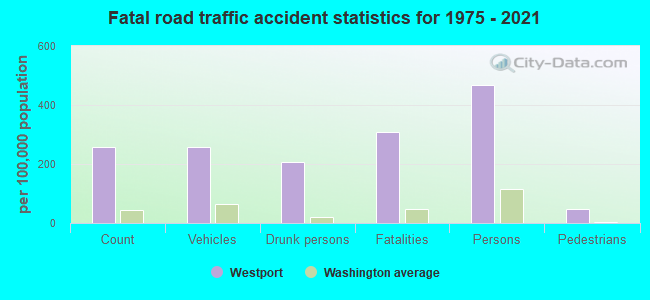
Westport fatal accident list:
May 29, 1998 03:15 PM, Sr-105, Vehicles: 1, Persons: 1, Fatalities: 1, Drunk persons involved: 1
Feb 17, 1991 02:00 AM, Westhaven, Vehicles: 1, Persons: 3, Fatalities: 2, Drunk persons involved: 1
Oct 17, 1991 04:51 PM, 105, Vehicles: 1, Persons: 2, Fatalities: 1, Drunk persons involved: 1
Mar 17, 1989 09:25 PM, Smontesano, Vehicles: 1, Persons: 2, Fatalities: 1, Drunk persons involved: 1
FCC Registered Broadcast Land Mobile Towers: 14 (See the full list of FCC Registered Broadcast Land Mobile Towers in Westport, WA)
FCC Registered Microwave Towers: 6 (See the full list of FCC Registered Microwave Towers in this town)
FCC Registered Maritime Coast & Aviation Ground Towers: 12 (See the full list of FCC Registered Maritime Coast & Aviation Ground Towers)
FCC Registered Amateur Radio Licenses: 39 (See the full list of FCC Registered Amateur Radio Licenses in Westport)
2002 - 2018 National Fire Incident Reporting System (NFIRS) incidents
- Fire incident types reported to NFIRS in Westport, WA
- 21333.7%Structure Fires
- 18629.4%Other
- 17728.0%Outside Fires
- 568.9%Mobile Property/Vehicle Fires
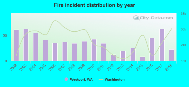 Based on the data from the years 2002 - 2018 the average number of fires per year is 37. The highest number of reported fire incidents - 62 took place in 2003, and the least - 8 in 2015. The data has a declining trend.
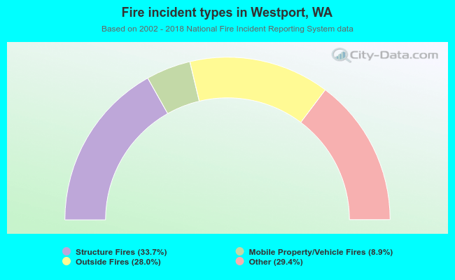 When looking into fire subcategories, the most reports belonged to: Structure Fires (33.7%), and Other (29.4%).
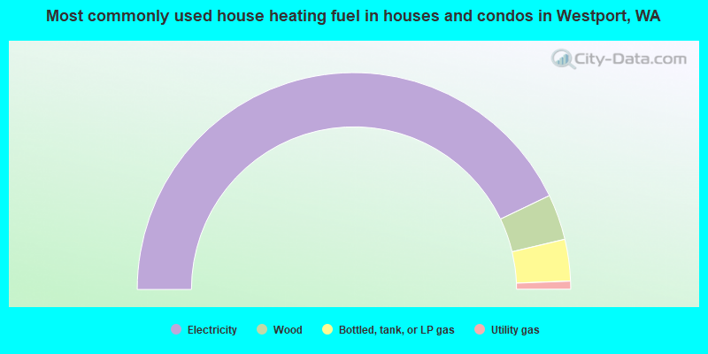
- 85.7%Electricity
- 6.8%Wood
- 6.2%Bottled, tank, or LP gas
- 1.2%Utility gas
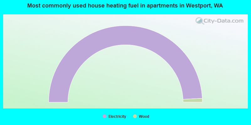
- 98.4%Electricity
- 1.6%Wood
Westport compared to Washington state average:
- Median household income below state average.
- Median house value below state average.
- Unemployed percentage below state average.
- Black race population percentage significantly below state average.
- Median age significantly above state average.
- Foreign-born population percentage significantly below state average.
- Length of stay since moving in significantly above state average.
Westport on our top lists:
- #27 on the list of "Top 101 cities with the most residents born in Austria (population 500+)"
- #27 on the list of "Top 101 cities with the most residents born in Malaysia (population 500+)"
- #56 on the list of "Top 101 counties with highest percentage of residents voting for 3rd party candidates in the 2012 Presidential Election (pop. 50,000+)"

|
Total of 9 patent applications in 2008-2024.