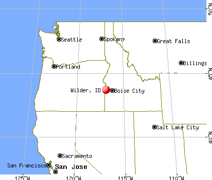
Wilder, Idaho
Submit your own pictures of this city and show them to the world
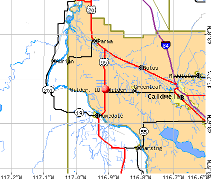
- OSM Map
- General Map
- Google Map
- MSN Map
Population change since 2000: +12.3%
 |
| Males: 765 | |
| Females: 877 |
| Median resident age: | 30.6 years |
| Idaho median age: | 37.5 years |
Zip codes: 83676.
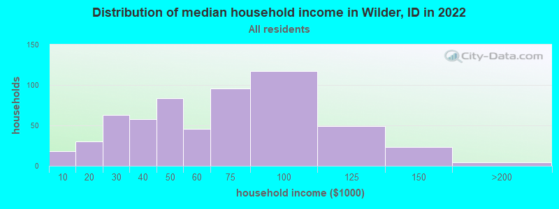
| Wilder: | $56,237 |
| ID: | $72,785 |
Estimated per capita income in 2022: $20,588 (it was $7,601 in 2000)
Wilder city income, earnings, and wages data
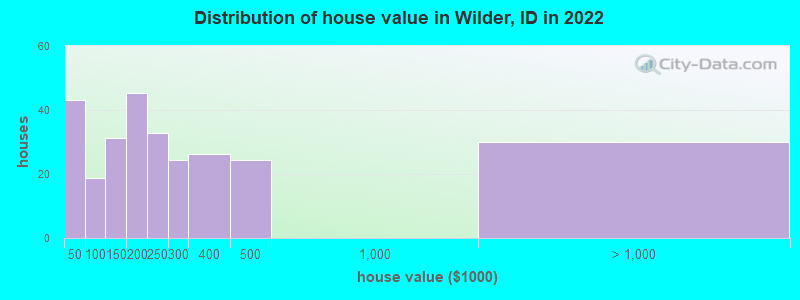
Estimated median house or condo value in 2022: $220,151 (it was $62,300 in 2000)
| Wilder: | $220,151 |
| ID: | $432,500 |
Mean prices in 2022: all housing units: $320,912; detached houses: $350,760; mobile homes: $19,977
Median gross rent in 2022: $828.
(5.5% for White Non-Hispanic residents, 24.4% for Hispanic or Latino residents, 23.5% for other race residents, 4.5% for two or more races residents)
Detailed information about poverty and poor residents in Wilder, ID
Compare current foreclosures near Wilder, ID:
| Photo | Address | Area | Beds / Baths | Price | Details |
|---|---|---|---|---|---|

|
#1
Jacks Rd
Parma, ID 83660
|
2,340 sq. feet
|
3 baths 5 beds |
show details | |

|
#2
N Montana Ave
Caldwell, ID 83605
|
2,408 sq. feet
|
3 baths 4 beds |
show details | |

|
#3
Vine St
Middleton, ID 83644
|
1,524 sq. feet
|
1 baths 3 beds |
show details | |

|
#4
Kennebec Way
Caldwell, ID 83605
|
2,526 sq. feet
|
2 baths 4 beds |
show details | |

|
#5
Nanticoke Ave
Caldwell, ID 83605
|
2,025 sq. feet
|
2 baths 4 beds |
show details | |

|
#6
W Blueberry Ave
Nampa, ID 83651
|
1,258 sq. feet
|
2 baths 3 beds |
show details | |

|
#7
Roanoke Dr
Caldwell, ID 83605
|
1,261 sq. feet
|
2 baths 3 beds |
show details | |

|
#8
W Cannon River St
Nampa, ID 83686
|
2,530 sq. feet
|
2 baths 4 beds |
show details | |

|
#9
W Zachery Ave
Nampa, ID 83651
|
2,074 sq. feet
|
2 baths 3 beds |
show details | |

|
#10
Trailside Dr
Caldwell, ID 83607
|
1,002 sq. feet
|
2 baths 3 beds |
show details |
| Photo | Address | Area | Beds / Baths | Price | Details |
|---|---|---|---|---|---|

|
#11
Olympia Dr
Caldwell, ID 83605
|
1,848 sq. feet
|
2 baths 3 beds |
show details | |

|
#12
Citrus St
Caldwell, ID 83605
|
2,038 sq. feet
|
2 baths 3 beds |
show details | |

|
#13
Pluto Cir
Caldwell, ID 83605
|
1,336 sq. feet
|
2 baths 3 beds |
show details | |

|
#14
N La Cresta Ave
Caldwell, ID 83605
|
960 sq. feet
|
1 baths 3 beds |
show details | |

|
#15
Elton Ln
Caldwell, ID 83607
|
1,203 sq. feet
|
2 baths 3 beds |
show details | |

|
#16
Terrace Dr
Caldwell, ID 83605
|
1,358 sq. feet
|
2 baths 3 beds |
show details | |

|
#17
Southwell Ct
Middleton, ID 83644
|
2,509 sq. feet
|
2 baths 4 beds |
show details | |

|
#18
Challis Pl
Caldwell, ID 83605
|
2,129 sq. feet
|
2 baths 4 beds |
show details | |

|
#19
Taft St
Caldwell, ID 83605
|
1,404 sq. feet
|
1 baths 3 beds |
show details | |

|
#20
W Mcgraw Dr
Nampa, ID 83651
|
1,570 sq. feet
|
2 baths 3 beds |
show details |
| Photo | Address | Area | Beds / Baths | Price | Details |
|---|---|---|---|---|---|

|
#21
Cantrice Ln
Caldwell, ID 83607
|
1,540 sq. feet
|
2 baths 3 beds |
show details | |

|
#22
Antelope Way
Caldwell, ID 83607
|
1,307 sq. feet
|
2 baths 3 beds |
show details | |

|
#23
Bismark Ave
Caldwell, ID 83605
|
943 sq. feet
|
2 baths 3 beds |
show details | |

|
#24
Pembrook Ave
Caldwell, ID 83605
|
1,523 sq. feet
|
2 baths 3 beds |
show details | |

|
#25
Notus Rd
Caldwell, ID 83607
|
1,216 sq. feet
|
1 baths 2 beds |
show details | |

|
#26
W Kipling Way
Nampa, ID 83651
|
2,010 sq. feet
|
2 baths 4 beds |
show details | |

|
#27
Purple Sage Rd, Trlr 30
Caldwell, ID 83607
|
672 sq. feet
|
1 baths 2 beds |
show details | |

|
#28
Leo Dr
Nampa, ID 83651
|
1,322 sq. feet
|
2 baths 3 beds |
show details | |

|
#29
River Rd
Caldwell, ID 83607
|
1,342 sq. feet
|
2 baths 3 beds |
show details | |

|
#30
W Halverson St
Middleton, ID 83644
|
1,620 sq. feet
|
2 baths 4 beds |
show details |
| Photo | Address | Area | Beds / Baths | Price | Details |
|---|---|---|---|---|---|

|
#31
E Ash St
Caldwell, ID 83605
|
1,060 sq. feet
|
1 baths 3 beds |
show details | |

|
#32
Settlers Ave
Caldwell, ID 83607
|
1,121 sq. feet
|
2 baths 3 beds |
show details | |

|
#33
W Flamingo Ave, Trlr 25
Nampa, ID 83651
|
1,288 sq. feet
|
1 baths - beds |
show details | |

|
#34
N 6th St
Nyssa, OR 97913
|
- sq. feet
|
- baths - beds |
show details | |

|
#35
Smith Ave # 3
Nampa, ID 83651
|
- sq. feet
|
- baths - beds |
show details | |

|
#36
W Colorado River St
Nampa, ID 83686
|
- sq. feet
|
- baths - beds |
show details | |

|
#37
White River St
Caldwell, ID 83605
|
- sq. feet
|
- baths - beds |
show details | |

|
#38
Boise St Apt 104
Middleton, ID 83644
|
- sq. feet
|
- baths - beds |
show details | |

|
#39
W Terrazzo Dr
Nampa, ID 83651
|
- sq. feet
|
- baths - beds |
show details | |

|
#40
Cherry Ln # 203
Nampa, ID 83687
|
- sq. feet
|
- baths - beds |
show details |
| Photo | Address | Area | Beds / Baths | Price | Details |
|---|---|---|---|---|---|

|
#41
Ehrgood Ave
Nyssa, OR 97913
|
1,344 sq. feet
|
- baths - beds |
show details | |

|
#42
Emison Ave
Nyssa, OR 97913
|
900 sq. feet
|
- baths - beds |
show details | |

|
#43
W Crested Butte Ct
Nampa, ID 83651
|
- sq. feet
|
- baths - beds |
show details | |

|
#44
Stanley Lake St
Middleton, ID 83644
|
- sq. feet
|
- baths - beds |
show details | |

|
#45
N Middleton Rd # D
Middleton, ID 83644
|
- sq. feet
|
- baths - beds |
show details | |

|
#46
N Middleton Rd # C
Middleton, ID 83644
|
- sq. feet
|
- baths - beds |
show details | |

|
#47
Rocky Mountain Ln, Unit 102
Nampa, ID 83687
|
- sq. feet
|
- baths - beds |
show details | |

|
#48
Calico Ave
Nampa, ID 83687
|
- sq. feet
|
- baths - beds |
show details | |

|
#49
W Brassy Cove Loop Apt 201
Nampa, ID 83651
|
- sq. feet
|
- baths - beds |
show details | |

|
Check over 1 million property listings on Foreclosure.com!
|
browse all offers | |||


- 1,16365.1%Hispanic
- 51228.7%White alone
- 663.7%Two or more races
- 191.1%Other race alone
- 150.8%Native Hawaiian and Other
Pacific Islander alone - 70.4%Asian alone
- 50.3%American Indian alone
- 20.1%Black alone
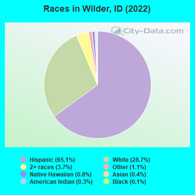
Races in Wilder detailed stats: ancestries, foreign born residents, place of birth
According to our research of Idaho and other state lists, there were 23 registered sex offenders living in Wilder, Idaho as of April 26, 2024.
The ratio of all residents to sex offenders in Wilder is 64 to 1.
Type |
2009 |
2010 |
2011 |
2012 |
2013 |
2014 |
2015 |
2016 |
2017 |
2018 |
2019 |
2020 |
2021 |
2022 |
|---|---|---|---|---|---|---|---|---|---|---|---|---|---|---|
| Murders (per 100,000) | 0 (0.0) | 0 (0.0) | 0 (0.0) | 0 (0.0) | 0 (0.0) | 0 (0.0) | 0 (0.0) | 0 (0.0) | 0 (0.0) | 0 (0.0) | 0 (0.0) | 0 (0.0) | 0 (0.0) | 0 (0.0) |
| Rapes (per 100,000) | 0 (0.0) | 0 (0.0) | 0 (0.0) | 1 (63.8) | 0 (0.0) | 0 (0.0) | 0 (0.0) | 0 (0.0) | 0 (0.0) | 0 (0.0) | 0 (0.0) | 1 (53.8) | 2 (108.5) | 2 (116.3) |
| Robberies (per 100,000) | 0 (0.0) | 0 (0.0) | 1 (64.5) | 1 (63.8) | 0 (0.0) | 2 (126.0) | 0 (0.0) | 0 (0.0) | 0 (0.0) | 0 (0.0) | 0 (0.0) | 0 (0.0) | 0 (0.0) | 0 (0.0) |
| Assaults (per 100,000) | 5 (339.2) | 2 (130.5) | 2 (129.0) | 2 (127.6) | 3 (191.3) | 4 (252.0) | 3 (186.0) | 6 (365.9) | 2 (117.9) | 2 (114.4) | 0 (0.0) | 0 (0.0) | 0 (0.0) | 4 (232.6) |
| Burglaries (per 100,000) | 4 (271.4) | 5 (326.2) | 5 (322.6) | 5 (318.9) | 6 (382.7) | 5 (315.1) | 7 (434.0) | 7 (426.8) | 12 (707.1) | 2 (114.4) | 0 (0.0) | 5 (269.1) | 5 (271.3) | 7 (407.0) |
| Thefts (per 100,000) | 15 (1,018) | 17 (1,109) | 8 (516.1) | 7 (446.4) | 11 (701.5) | 15 (945.2) | 10 (620.0) | 16 (975.6) | 9 (530.3) | 4 (228.8) | 2 (109.5) | 11 (592.0) | 4 (217.0) | 8 (465.1) |
| Auto thefts (per 100,000) | 1 (67.8) | 0 (0.0) | 2 (129.0) | 2 (127.6) | 0 (0.0) | 2 (126.0) | 2 (124.0) | 5 (304.9) | 3 (176.8) | 1 (57.2) | 3 (164.2) | 0 (0.0) | 0 (0.0) | 3 (174.4) |
| Arson (per 100,000) | 1 (67.8) | 0 (0.0) | 0 (0.0) | 0 (0.0) | 0 (0.0) | 0 (0.0) | 0 (0.0) | 1 (61.0) | 0 (0.0) | 0 (0.0) | 0 (0.0) | 0 (0.0) | 0 (0.0) | 0 (0.0) |
| City-Data.com crime index | 133.0 | 93.3 | 98.7 | 146.0 | 93.1 | 158.2 | 102.3 | 166.5 | 108.4 | 44.6 | 17.5 | 85.6 | 114.5 | 200.6 |
The City-Data.com crime index weighs serious crimes and violent crimes more heavily. Higher means more crime, U.S. average is 246.1. It adjusts for the number of visitors and daily workers commuting into cities.
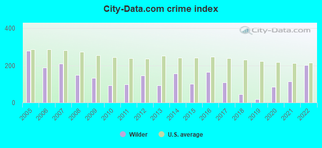
Crime rate in Wilder detailed stats: murders, rapes, robberies, assaults, burglaries, thefts, arson
Full-time law enforcement employees in 2021, including police officers: 5 (5 officers - 4 male; 1 female).
| Officers per 1,000 residents here: | 2.71 |
| Idaho average: | 1.59 |
 Recent articles from our blog. Our writers, many of them Ph.D. graduates or candidates, create easy-to-read articles on a wide variety of topics.

 | Any other lifetime Boiseans fed up and leaving??? (47 replies) |
| Small cabin builder (7 replies) |
| Coronavirus in Idaho (63 replies) |
| 2 nights/1 day in Sun Valley. Worth it? (while on our way to Grand Teton/Yellowstone) (18 replies) |
| Utility costs in Caldwell area (7 replies) |
| Looking for safe, creative--good vibes--type community in Idaho: Help please. (107 replies) |
Latest news from Wilder, ID collected exclusively by city-data.com from local newspapers, TV, and radio stations
Ancestries: English (5.4%), German (3.1%), Irish (3.0%), Italian (1.6%).
Current Local Time: MST time zone
Elevation: 2424 feet
Land area: 0.38 square miles.
Population density: 4,364 people per square mile (average).
426 residents are foreign born (22.8% Latin America).
| This city: | 23.9% |
| Idaho: | 5.7% |
| Wilder city: | 1.1% ($712) |
| Idaho: | 1.0% ($1,007) |
Nearest city with pop. 50,000+: Nampa, ID  (18.7 miles , pop. 51,867).
Nearest city with pop. 200,000+: Northwest Clackamas, OR (305.5 miles , pop. 224,220).
Nearest city with pop. 1,000,000+: Los Angeles, CA (668.0 miles , pop. 3,694,820).
Nearest cities:
), ), ), Latitude: 43.68 N, Longitude: 116.91 W
Area code: 208

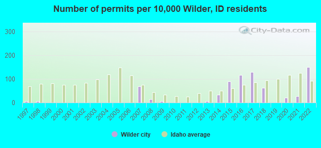
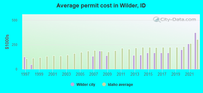
Single-family new house construction building permits:
- 2022: 22 buildings, average cost: $373,900
- 2021: 4 buildings, average cost: $260,400
- 2020: 3 buildings, average cost: $198,100
- 2018: 9 buildings, average cost: $168,400
- 2017: 19 buildings, average cost: $167,200
- 2016: 17 buildings, average cost: $168,600
- 2015: 13 buildings, average cost: $167,600
- 2014: 5 buildings, average cost: $144,200
- 2013: 1 building, cost: $140,600
- 2009: 1 building, cost: $138,500
- 2008: 2 buildings, average cost: $185,800
- 2007: 10 buildings, average cost: $132,400
- 1998: 1 building, cost: $45,500
- 1997: 1 building, cost: $126,200
| Here: | 3.5% |
| Idaho: | 3.1% |
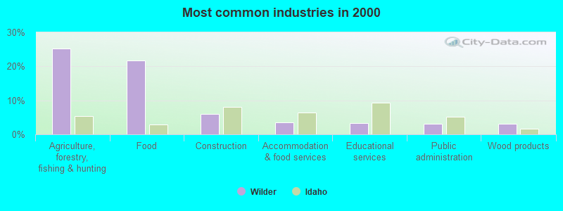
- Agriculture, forestry, fishing & hunting (25.3%)
- Food (21.8%)
- Construction (6.0%)
- Accommodation & food services (3.5%)
- Educational services (3.3%)
- Public administration (3.1%)
- Wood products (3.1%)
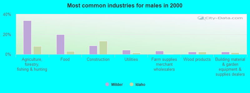
- Agriculture, forestry, fishing & hunting (33.9%)
- Food (19.9%)
- Construction (8.8%)
- Utilities (4.2%)
- Farm supplies merchant wholesalers (3.3%)
- Wood products (2.6%)
- Building material & garden equipment & supplies dealers (2.6%)
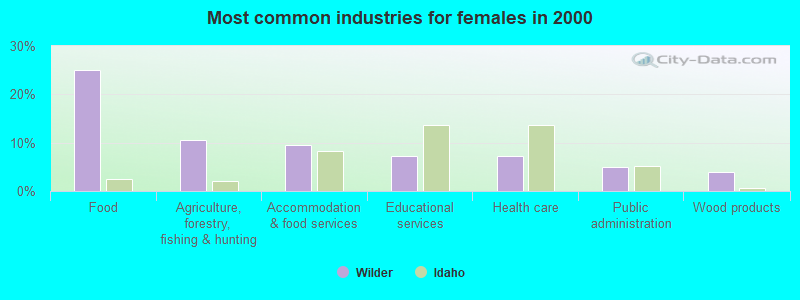
- Food (25.0%)
- Agriculture, forestry, fishing & hunting (10.6%)
- Accommodation & food services (9.4%)
- Educational services (7.2%)
- Health care (7.2%)
- Public administration (5.0%)
- Wood products (3.9%)
- Agricultural workers, including supervisors (23.4%)
- Other production occupations, including supervisors (11.5%)
- Laborers and material movers, hand (5.3%)
- Food processing workers (5.1%)
- Other material moving workers, except laborers (3.5%)
- Other office and administrative support workers, including supervisors (2.5%)
- Cashiers (2.5%)
- Agricultural workers, including supervisors (30.3%)
- Other production occupations, including supervisors (10.1%)
- Laborers and material movers, hand (6.2%)
- Other material moving workers, except laborers (5.5%)
- Carpenters (3.6%)
- Driver/sales workers and truck drivers (3.6%)
- Pipelayers, plumbers, pipefitters, and steamfitters (2.9%)
- Other production occupations, including supervisors (13.9%)
- Agricultural workers, including supervisors (11.7%)
- Food processing workers (9.4%)
- Waiters and waitresses (5.0%)
- Financial clerks, except bookkeeping, accounting and auditing clerks (4.4%)
- Laborers and material movers, hand (3.9%)
- Building and grounds cleaning and maintenance occupations (3.9%)
Average climate in Wilder, Idaho
Based on data reported by over 4,000 weather stations


|
|


(lower is better)
Air Quality Index (AQI) level in 2022 was 87.5. This is worse than average.
| City: | 87.5 |
| U.S.: | 72.6 |
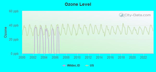
Ozone [ppb] level in 2004 was 29.5. This is about average. Closest monitor was 14.4 miles away from the city center.
| City: | 29.5 |
| U.S.: | 33.3 |
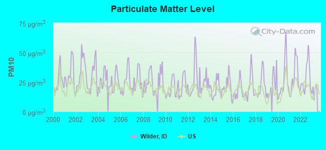
Particulate Matter (PM10) [µg/m3] level in 2022 was 29.1. This is significantly worse than average. Closest monitor was 18.6 miles away from the city center.
| City: | 29.1 |
| U.S.: | 19.2 |
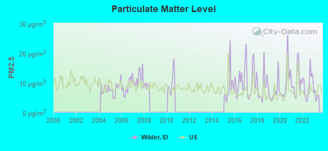
Particulate Matter (PM2.5) [µg/m3] level in 2022 was 9.43. This is about average. Closest monitor was 8.0 miles away from the city center.
| City: | 9.43 |
| U.S.: | 8.11 |
Earthquake activity:
Wilder-area historical earthquake activity is significantly above Idaho state average. It is 2287% greater than the overall U.S. average.On 10/3/1915 at 06:52:48, a magnitude 7.6 (7.6 UK, Class: Major, Intensity: VIII - XII) earthquake occurred 221.8 miles away from the city center
On 10/28/1983 at 14:06:06, a magnitude 7.3 (6.2 MB, 7.3 MS, 7.0 MW) earthquake occurred 157.4 miles away from the city center, causing 2 deaths (2 shaking deaths) and 3 injuries, causing $15,000,000 total damage
On 8/18/1959 at 06:37:13, a magnitude 7.7 (7.7 UK) earthquake occurred 316.5 miles away from Wilder center, causing $26,000,000 total damage
On 3/31/2020 at 23:52:30, a magnitude 6.5 (6.5 MW, Depth: 7.5 mi, Class: Strong, Intensity: VII - IX) earthquake occurred 104.4 miles away from Wilder center
On 12/16/1954 at 11:07:12, a magnitude 7.0 (7.0 UK) earthquake occurred 314.7 miles away from the city center
On 12/21/1932 at 06:10:09, a magnitude 7.2 (7.2 UK) earthquake occurred 362.5 miles away from the city center
Magnitude types: body-wave magnitude (MB), surface-wave magnitude (MS), moment magnitude (MW)
Natural disasters:
The number of natural disasters in Canyon County (3) is a lot smaller than the US average (15).Emergencies Declared: 1
Causes of natural disasters: Flood: 1, Hurricane: 1, Other: 1 (Note: some incidents may be assigned to more than one category).

Hospitals and medical centers near Wilder:
- KINDRED NURSING AND REHAB - CALDWELL (Nursing Home, about 11 miles away; CALDWELL, ID)
- WEST VALLEY MEDICAL CENTER Acute Care Hospitals (about 11 miles away; CALDWELL, ID)
- KINDRED NURSING AND REHAB - CANYON WEST (Nursing Home, about 13 miles away; CALDWELL, ID)
- MALHEUR MEMORIAL HOSPITAL (Nursing Home, about 15 miles away; NYSSA, OR)
Colleges/universities with over 2000 students nearest to Wilder:
- Northwest Nazarene University (about 19 miles; Nampa, ID; Full-time enrollment: 2,290)
- College of Western Idaho (about 21 miles; Nampa, ID; FT enrollment: 6,300)
- Treasure Valley Community College (about 24 miles; Ontario, OR; FT enrollment: 2,055)
- Boise State University (about 36 miles; Boise, ID; FT enrollment: 16,774)
- Eastern Oregon University (about 128 miles; La Grande, OR; FT enrollment: 3,127)
- College of Southern Idaho (about 145 miles; Twin Falls, ID; FT enrollment: 5,051)
- Walla Walla Community College (about 180 miles; Walla Walla, WA; FT enrollment: 4,263)
Points of interest:
Notable location: Wilder Rural Fire Protection District (A). Display/hide its location on the map
Birthplace of: Phil Batt - Politician.
Drinking water stations with addresses in Wilder and their reported violations in the past:
RIVER BEND GOLF COURSE (Population served: 150, Groundwater):Past monitoring violations:
- One routine major monitoring violation
| This city: | 3.4 people |
| Idaho: | 2.7 people |
| This city: | 77.9% |
| Whole state: | 69.6% |
| This city: | 5.5% |
| Whole state: | 6.3% |
Likely homosexual households (counted as self-reported same-sex unmarried-partner households)
- Lesbian couples: 0.2% of all households
- Gay men: 0.7% of all households
Banks with branches in Wilder (2011 data):
- Zions First National Bank: Wilder Branch at 315 Avenue A, branch established on 1946/12/06. Info updated 2006/11/03: Bank assets: $17,531.3 mil, Deposits: $14,905.3 mil, headquarters in Salt Lake City, UT, positive income, Commercial Lending Specialization, 151 total offices, Holding Company: Zions Bancorporation
For population 15 years and over in Wilder:
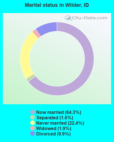
- Never married: 22.4%
- Now married: 64.3%
- Separated: 1.6%
- Widowed: 1.9%
- Divorced: 9.9%
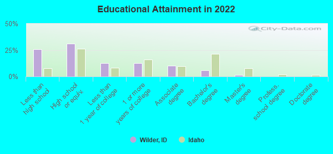
For population 25 years and over in Wilder:
- High school or higher: 71.2%
- Bachelor's degree or higher: 7.0%
- Graduate or professional degree: 1.7%
- Unemployed: 16.2%
- Mean travel time to work (commute): 20.5 minutes
| Here: | 16.2 |
| Idaho average: | 11.0 |
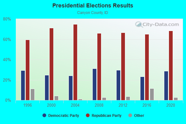
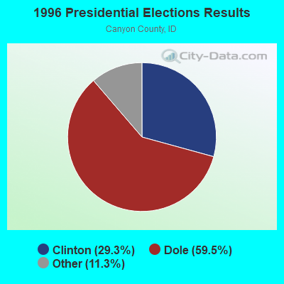
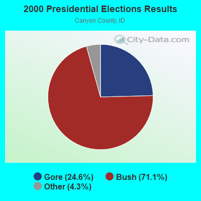
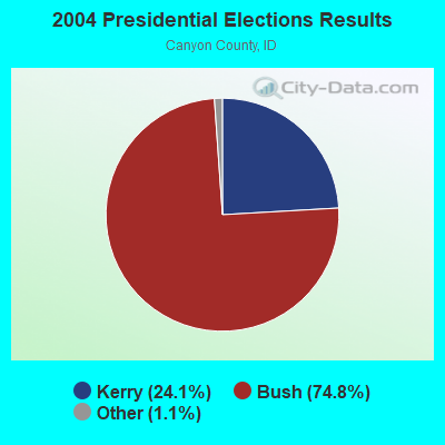
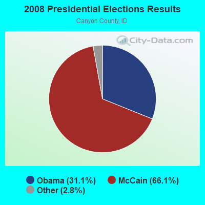
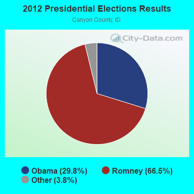
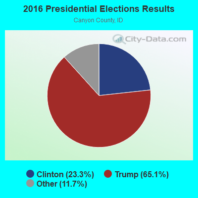
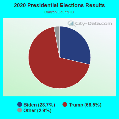
Graphs represent county-level data. Detailed 2008 Election Results
Religion statistics for Wilder, ID (based on Canyon County data)
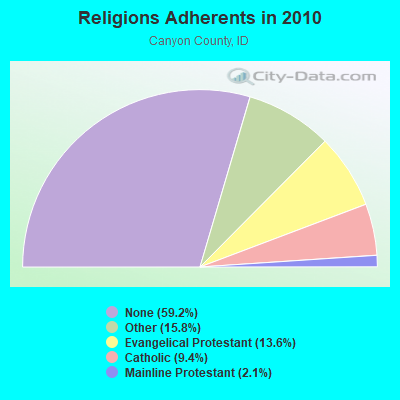
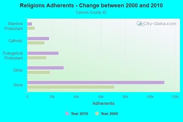
| Religion | Adherents | Congregations |
|---|---|---|
| Other | 29,810 | 68 |
| Evangelical Protestant | 25,615 | 114 |
| Catholic | 17,838 | 3 |
| Mainline Protestant | 3,881 | 19 |
| None | 111,779 | - |
Food Environment Statistics:
| This county: | 1.18 / 10,000 pop. |
| Idaho: | 1.88 / 10,000 pop. |
| This county: | 0.28 / 10,000 pop. |
| Idaho: | 0.28 / 10,000 pop. |
| Here: | 0.28 / 10,000 pop. |
| Idaho: | 0.53 / 10,000 pop. |
| Canyon County: | 2.35 / 10,000 pop. |
| Idaho: | 3.87 / 10,000 pop. |
| Here: | 4.37 / 10,000 pop. |
| State: | 7.75 / 10,000 pop. |
| Canyon County: | 7.7% |
| State: | 7.7% |
| This county: | 28.7% |
| Idaho: | 25.7% |
| Canyon County: | 15.7% |
| Idaho: | 11.7% |
Health and Nutrition:
| Wilder: | 44.3% |
| State: | 48.7% |
| This city: | 42.6% |
| Idaho: | 45.7% |
| Wilder: | 28.3 |
| Idaho: | 28.6 |
| Wilder: | 26.0% |
| Idaho: | 21.8% |
| Wilder: | 9.0% |
| Idaho: | 10.0% |
| This city: | 6.7 |
| Idaho: | 6.8 |
| Here: | 28.3% |
| State: | 33.4% |
| Wilder: | 51.5% |
| Idaho: | 56.0% |
| Wilder: | 79.8% |
| Idaho: | 78.5% |
More about Health and Nutrition of Wilder, ID Residents
| Local government employment and payroll (March 2022) | |||||
| Function | Full-time employees | Monthly full-time payroll | Average yearly full-time wage | Part-time employees | Monthly part-time payroll |
|---|---|---|---|---|---|
| Housing and Community Development (Local) | 5 | $15,307 | $36,737 | 1 | $717 |
| Police Protection - Officers | 5 | $19,543 | $46,903 | 0 | $0 |
| Other Government Administration | 2 | $6,244 | $37,464 | 10 | $916 |
| Financial Administration | 1 | $2,320 | $27,840 | 0 | $0 |
| Sewerage | 1 | $1,640 | $19,680 | 0 | $0 |
| Water Supply | 1 | $2,080 | $24,960 | 0 | $0 |
| Streets and Highways | 0 | $0 | 2 | $2,155 | |
| Police - Other | 0 | $0 | 1 | $80 | |
| Totals for Government | 15 | $47,135 | $37,708 | 14 | $3,868 |
Wilder government finances - Expenditure in 2018 (per resident):
- Construction - Water Utilities: $9,000 ($5.48)
Parks and Recreation: $8,000 ($4.87)
Police Protection: $6,000 ($3.65)
Financial Administration: $2,000 ($1.22)
Sewerage: $1,000 ($0.61)
- Current Operations - Regular Highways: $1,100,000 ($669.91)
Sewerage: $396,000 ($241.17)
Police Protection: $385,000 ($234.47)
Water Utilities: $216,000 ($131.55)
Central Staff Services: $82,000 ($49.94)
Financial Administration: $50,000 ($30.45)
Miscellaneous Commercial Activities - Other: $37,000 ($22.53)
Parks and Recreation: $23,000 ($14.01)
Protective Inspection and Regulation - Other: $17,000 ($10.35)
Solid Waste Management: $13,000 ($7.92)
Judicial and Legal Services: $5,000 ($3.05)
- General - Interest on Debt: $83,000 ($50.55)
- Other Capital Outlay - Sewerage: $57,000 ($34.71)
Water Utilities: $43,000 ($26.19)
Police Protection: $16,000 ($9.74)
Regular Highways: $13,000 ($7.92)
Parks and Recreation: $6,000 ($3.65)
Financial Administration: $1,000 ($0.61)
- Total Salaries and Wages: $457,000 ($278.32)
Wilder government finances - Revenue in 2018 (per resident):
- Charges - Sewerage: $416,000 ($253.35)
Solid Waste Management: $130,000 ($79.17)
Parks and Recreation: $1,000 ($0.61)
- Federal Intergovernmental - Sewerage: $12,000 ($7.31)
- Local Intergovernmental - General Local Government Support: $41,000 ($24.97)
Highways: $19,000 ($11.57)
- Miscellaneous - Fines and Forfeits: $32,000 ($19.49)
General Revenue - Other: $31,000 ($18.88)
Sale of Property: $1,000 ($0.61)
Interest Earnings: $0 ($0.00)
- Revenue - Water Utilities: $364,000 ($221.68)
- State Intergovernmental - General Local Government Support: $161,000 ($98.05)
Highways: $157,000 ($95.62)
Water Utilities: $2,000 ($1.22)
- Tax - Property: $305,000 ($185.75)
Occupation and Business License - Other: $24,000 ($14.62)
Public Utilities Sales: $14,000 ($8.53)
Other License: $13,000 ($7.92)
Alcoholic Beverage License: $1,000 ($0.61)
Wilder government finances - Debt in 2018 (per resident):
- Long Term Debt - Beginning Outstanding - Unspecified Public Purpose: $2,067,000 ($1258.83)
Outstanding Unspecified Public Purpose: $2,000,000 ($1218.03)
Retired Unspecified Public Purpose: $67,000 ($40.80)
Strongest AM radio stations in Wilder:
- KBOI (670 AM; 50 kW; BOISE, ID; Owner: CITADEL BROADCASTING COMPANY)
- KWEI (1260 AM; 50 kW; WEISER, ID; Owner: TREASURE VALLEY BROADCASTING CO.)
- KBGN (1060 AM; daytime; 10 kW; CALDWELL, ID; Owner: NELSON M. AND KAREN E. WILSON)
- KBSU (730 AM; 15 kW; BOISE, ID; Owner: IDAHO STATE BOARD OF EDUCATION)
- KIDO (580 AM; 5 kW; NAMPA, ID; Owner: CITICASTERS LICENSES, L.P.)
- KKIC (950 AM; 4 kW; BOISE, ID; Owner: WESTERN PACIFIC, INC)
- KGEM (1140 AM; 10 kW; BOISE, ID; Owner: JOURNAL BROADCAST CORPORATION)
- KFXD (630 AM; 5 kW; BOISE, ID; Owner: CITICASTERS LICENSES, L.P.)
- KSRV (1380 AM; 5 kW; ONTARIO, OR; Owner: HBG-RADIO ONTARIO LLC)
- KTIK (1350 AM; 5 kW; NAMPA, ID; Owner: CITADEL BROADCASTING COMPANY)
- KCID (1490 AM; 1 kW; CALDWELL, ID; Owner: JOURNAL BROADCAST CORPORATION)
- KSPD (790 AM; 1 kW; BOISE, ID; Owner: KSPD, INC.)
- KIOV (1450 AM; 1 kW; PAYETTE, ID; Owner: ASSOCIATES COMMUNICATIONS OF IDAHO,)
Strongest FM radio stations in Wilder:
- KJHY (101.9 FM; EMMETT, ID; Owner: CAPITAL WEST INC)
- KWEI-FM (99.5 FM; FRUITLAND, ID; Owner: TREASURE VALLEY BROADCASTING CO.)
- KIZN (92.3 FM; BOISE, ID; Owner: CITADEL BROADCASTING COMPANY)
- KKGL (96.9 FM; NAMPA, ID; Owner: CITADEL BROADCASTING COMPANY)
- KQFC (97.9 FM; BOISE, ID; Owner: CITADEL BROADCASTING COMPANY)
- KZMG (93.1 FM; NEW PLYMOUTH, ID; Owner: CITADEL BROADCASTING COMPANY)
- KBSU-FM (90.3 FM; BOISE, ID; Owner: IDAHO STATE BOARD OF EDUCATION)
- KBSX (91.5 FM; BOISE, ID; Owner: IDAHO STATE BOARD OF EDUCATION)
- KARO (98.7 FM; NYSSA, OR; Owner: EDUCATIONAL MEDIA FOUNDATION)
- KCIX (105.9 FM; GARDEN CITY, ID; Owner: CITICASTERS LICENSES, L.P.)
- KRVB (94.9 FM; NAMPA, ID; Owner: JOURNAL BROADCAST CORPORATION)
- KXLT-FM (107.9 FM; EAGLE, ID; Owner: CITICASTERS LICENSES, L.P.)
- KJOT (105.1 FM; BOISE, ID; Owner: JOURNAL BROADCAST CORPORATION)
- KTHI (107.1 FM; CALDWELL, ID; Owner: JOURNAL BROADCAST CORPORATION)
- KBXL (94.1 FM; CALDWELL, ID; Owner: KSPD, INC.)
- KTSY (89.5 FM; CALDWELL, ID; Owner: GEM STATE ADVENTIST ACADEMY)
- KSAS-FM (103.3 FM; CALDWELL, ID; Owner: CITICASTERS LICENSES, L.P.)
- KLTB (104.3 FM; BOISE, ID; Owner: CITICASTERS LICENSES, L.P.)
- KQXR (100.3 FM; PAYETTE, ID; Owner: JOURNAL BROADCAST CORPORATION)
- KSRV-FM (96.1 FM; ONTARIO, OR; Owner: HBG-RADIO ONTARIO LLC)
TV broadcast stations around Wilder:
- KMBA-LP (Channel 19; ONTARIO, OR; Owner: TREASURE VALLEY COMMUNITY COLLEGE)
Wilder fatal accident list:
Jun 25, 2015 04:04 PM, Us-95, Red Top Road, Lat: 43.690644, Lon: -116.911972, Vehicles: 2, Persons: 3, Fatalities: 1
Oct 18, 2013 03:24 AM, Sr-19, Lat: 43.668833, Lon: -116.884575, Vehicles: 2, Persons: 3, Fatalities: 2, Drunk persons involved: 1
Jun 7, 2012 09:00 PM, Fargo Rd, Peckham Rd, Lat: 43.675944, Lon: -116.931933, Vehicles: 2, Persons: 2, Fatalities: 1, Drunk persons involved: 1
- National Bridge Inventory (NBI) Statistics
- 16Number of bridges
- 56ft / 17.5mTotal length
- $802,000Total costs
- 20,175Total average daily traffic
- 2,117Total average daily truck traffic
- 30,263Total future (year 2039) average daily traffic
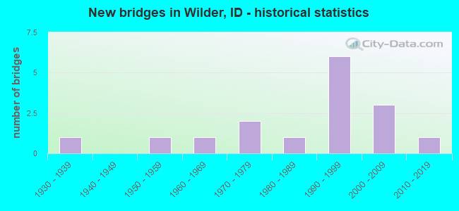
- New bridges - historical statistics
- 11930-1939
- 11950-1959
- 11960-1969
- 21970-1979
- 11980-1989
- 61990-1999
- 32000-2009
- 12010-2019
FCC Registered Cell Phone Towers:
2 (See the full list of FCC Registered Cell Phone Towers in Wilder)FCC Registered Antenna Towers:
46 (See the full list of FCC Registered Antenna Towers)FCC Registered Broadcast Land Mobile Towers:
8 (See the full list of FCC Registered Broadcast Land Mobile Towers in Wilder, ID)FCC Registered Microwave Towers:
25 (See the full list of FCC Registered Microwave Towers in this town)FCC Registered Amateur Radio Licenses:
54 (See the full list of FCC Registered Amateur Radio Licenses in Wilder)FAA Registered Aircraft:
5- Aircraft: TUCKER THADDEUS D VANS RV-6 (Category: Land, Seats: 2, Weight: Up to 12,499 Pounds), Engine: LYCOMING I0360 SER (180 HP) (Reciprocating)
N-Number: 104TT, N104TT, N-104TT, Serial Number: 60531, Year manufactured: 2003, Airworthiness Date: 07/17/2003, Certificate Issue Date: 11/27/2002
Registrant (Individual): Thaddeus D Tucker, 19807 Hun Ln, Wilder, ID 83676 - Aircraft: AMAN J MARK SKY STAR OUTBACK (Category: Land, Seats: 2, Weight: Up to 12,499 Pounds), Engine: CONT MOTOR IO-240 SER (128 HP) (Reciprocating)
N-Number: 2326L, N2326L, N-2326L, Serial Number: SS9901-0185, Year manufactured: 1999, Airworthiness Date: 04/05/2000, Certificate Issue Date: 01/29/2018
Registrant (Co-Owned): Andrew J Bartles, 29673 Peckham Rd, Wilder, ID 83676, Other Owners: Edward J Leavitt - Aircraft: CESSNA 182A (Category: Land, Seats: 4, Weight: Up to 12,499 Pounds, Speed: 119 mph), Engine: CONT MOTOR O-470 SERIES (230 HP) (Reciprocating)
N-Number: 5866B, N5866B, N-5866B, Serial Number: 33866, Year manufactured: 1956, Airworthiness Date: 12/06/1956, Certificate Issue Date: 11/07/2018
Registrant (Individual): Bradford K Young, 1125 Bushnell Ave, Wilder, ID 83676 - Aircraft: PIPER PA-12 (Category: Land, Seats: 3, Weight: Up to 12,499 Pounds, Speed: 82 mph), Engine: LYCOMING 0-320 SERIES (180 HP) (Reciprocating)
N-Number: 87806, N87806, N-87806, Serial Number: 12-7, Year manufactured: 1946, Airworthiness Date: 04/01/1958, Certificate Issue Date: 09/27/2016
Registrant (Co-Owned): Russell G Tackett, 25026 Boehner Rd, Wilder, ID 83676, Other Owners: Tracie L Tackett - Aircraft: PARKER JUDSON B SERIES 5 (Category: Land, Seats: 2, Weight: Up to 12,499 Pounds), Engine: Reciprocating
N-Number: 695CP, N695CP, N-695CP, Serial Number: S9506-0130, Certificate Issue Date: 02/07/1996
Registrant (Partnership): Judson Parker, 28081 Watkins Glen Ct, Wilder, ID 83676, Other Owners: Clarissa Parker
| Home Mortgage Disclosure Act Aggregated Statistics For Year 2009 (Based on 1 partial tract) | ||
| C) Refinancings | ||
|---|---|---|
| Number | Average Value | |
| LOANS ORIGINATED | 1 | $100,720 |
| APPLICATIONS APPROVED, NOT ACCEPTED | 0 | $0 |
| APPLICATIONS DENIED | 0 | $0 |
| APPLICATIONS WITHDRAWN | 0 | $0 |
| FILES CLOSED FOR INCOMPLETENESS | 0 | $0 |
Detailed HMDA statistics for the following Tracts: 0222.00
2002 - 2018 National Fire Incident Reporting System (NFIRS) incidents
- Fire incident types reported to NFIRS in Wilder, ID
- 35159.8%Outside Fires
- 14725.0%Structure Fires
- 6911.8%Mobile Property/Vehicle Fires
- 203.4%Other
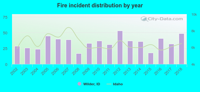 Based on the data from the years 2002 - 2018 the average number of fire incidents per year is 35. The highest number of fires - 53 took place in 2012, and the least - 17 in 2008. The data has an increasing trend.
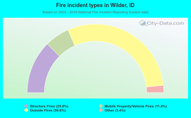 When looking into fire subcategories, the most reports belonged to: Outside Fires (59.8%), and Structure Fires (25.0%).
| Most common first names in Wilder, ID among deceased individuals | ||
| Name | Count | Lived (average) |
|---|---|---|
| John | 23 | 79.9 years |
| William | 14 | 80.7 years |
| Charles | 14 | 76.8 years |
| James | 14 | 75.4 years |
| Robert | 12 | 74.8 years |
| Mary | 10 | 84.6 years |
| Frank | 7 | 79.0 years |
| Richard | 7 | 72.3 years |
| Edna | 7 | 84.4 years |
| Fred | 7 | 80.1 years |
| Most common last names in Wilder, ID among deceased individuals | ||
| Last name | Count | Lived (average) |
|---|---|---|
| Howell | 10 | 79.4 years |
| Page | 8 | 74.7 years |
| Brown | 6 | 76.3 years |
| Norris | 6 | 71.4 years |
| Olsen | 6 | 83.2 years |
| Smith | 6 | 78.8 years |
| Johnson | 5 | 78.4 years |
| Rodriguez | 5 | 70.0 years |
| Shields | 5 | 72.2 years |
| Jenkins | 4 | 77.8 years |
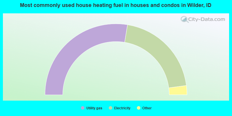
- 55.5%Utility gas
- 40.8%Electricity
- 2.9%Fuel oil, kerosene, etc.
- 0.9%Wood
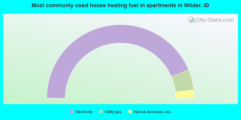
- 87.4%Electricity
- 9.1%Utility gas
- 3.5%Fuel oil, kerosene, etc.
Wilder compared to Idaho state average:
- Median house value below state average.
- Black race population percentage significantly below state average.
- Hispanic race population percentage significantly above state average.
- Median age significantly below state average.
- Foreign-born population percentage significantly above state average.
- Renting percentage above state average.
- Length of stay since moving in significantly above state average.
- Percentage of population with a bachelor's degree or higher significantly below state average.

|
Total of 18 patent applications in 2008-2024.