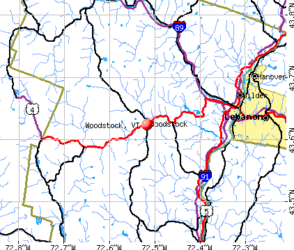
Woodstock, Vermont
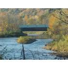
Woodstock: Covered bridge over the Ottauqueechee River, just West of Woodstock village.

Woodstock: Creekside Boutique, Woodstock, VT
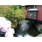
Woodstock: Creekside Boutique, Woodstock, VT
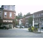
Woodstock: Main Street, Woodstock VT
- add
your
Submit your own pictures of this village and show them to the world
- OSM Map
- General Map
- Google Map
- MSN Map
Population change since 2000: -3.9%
 |
| Males: 407 | |
| Females: 532 |
| Median resident age: | 58.5 years |
| Vermont median age: | 43.2 years |
Zip codes: 05091.
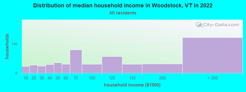
| Woodstock: | $85,509 |
| VT: | $73,991 |
Estimated per capita income in 2022: $69,576 (it was $28,639 in 2000)
Woodstock village income, earnings, and wages data
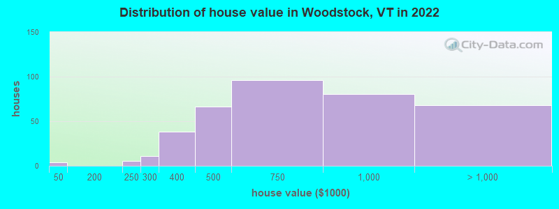
Estimated median house or condo value in 2022: $677,633 (it was $204,800 in 2000)
| Woodstock: | $677,633 |
| VT: | $304,700 |
Mean prices in 2022: all housing units: $702,990; detached houses: $790,963; townhouses or other attached units: $480,668; in 2-unit structures: $464,603; in 3-to-4-unit structures: $796,911; in 5-or-more-unit structures: $250,641
Median gross rent in 2022: $1,098.
Detailed information about poverty and poor residents in Woodstock, VT
Compare current foreclosures near Woodstock, VT:
| Photo | Address | Area | Beds / Baths | Price | Details |
|---|---|---|---|---|---|

|
#1
Doe Hill Way
Woodstock, VT 05091
|
1,264 sq. feet
|
1 baths 1 beds |
$262,900
|
show details |

|
#2
Winter St W
West Lebanon, NH 03784
|
894 sq. feet
|
1 baths 2 beds |
show details | |

|
#3
Bank Street Ext
Lebanon, NH 03766
|
1,232 sq. feet
|
1 baths 4 beds |
show details | |

|
#4
Orchard Rd
Enfield, NH 03748
|
1,056 sq. feet
|
2 baths 2 beds |
show details | |

|
#5
Dawn Dr
White River Junction, VT 05001
|
- sq. feet
|
- baths - beds |
show details | |

|
#6
N Puckerbrush Rd
Reading, VT 05062
|
- sq. feet
|
- baths - beds |
show details | |

|
#7
S Main St Apt 2
White River Junction, VT 05001
|
- sq. feet
|
- baths - beds |
show details | |

|
#8
Bavier Ave
Windsor, VT 05089
|
- sq. feet
|
- baths - beds |
show details | |

|
#9
Renihan Mdws
Lebanon, NH 03766
|
- sq. feet
|
- baths - beds |
show details | |

|
#10
Dairy Hill Rd
South Royalton, VT 05068
|
- sq. feet
|
- baths - beds |
show details |
| Photo | Address | Area | Beds / Baths | Price | Details |
|---|---|---|---|---|---|

|
#11
Downing Rd
Hanover, NH 03755
|
- sq. feet
|
- baths - beds |
show details | |

|
#12
Dillon Rd
Ludlow, VT 05149
|
- sq. feet
|
- baths - beds |
show details | |

|
#13
Upper Falls Rd
Perkinsville, VT 05151
|
- sq. feet
|
- baths - beds |
show details | |

|
Check over 1 million property listings on Foreclosure.com!
|
browse all offers | |||


- 1,00296.5%White alone
- 171.6%Two or more races
- 50.5%Black alone
- 20.2%Hispanic
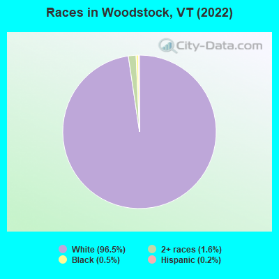
Races in Woodstock detailed stats: ancestries, foreign born residents, place of birth
According to our research of Vermont and other state lists, there were 2 registered sex offenders living in Woodstock, Vermont as of April 27, 2024.
The ratio of all residents to sex offenders in Woodstock is 526 to 1.
The ratio of registered sex offenders to all residents in this city is near the state average.
Type |
2009 |
2010 |
2011 |
2012 |
2013 |
2014 |
2015 |
2016 |
2017 |
2018 |
2019 |
2020 |
2021 |
2022 |
|---|---|---|---|---|---|---|---|---|---|---|---|---|---|---|
| Murders (per 100,000) | 0 (0.0) | 0 (0.0) | 0 (0.0) | 0 (0.0) | 0 (0.0) | 0 (0.0) | 0 (0.0) | 0 (0.0) | 0 (0.0) | 0 (0.0) | 0 (0.0) | 0 (0.0) | 0 (0.0) | 0 (0.0) |
| Rapes (per 100,000) | 0 (0.0) | 0 (0.0) | 0 (0.0) | 1 (32.8) | 0 (0.0) | 1 (33.4) | 0 (0.0) | 0 (0.0) | 0 (0.0) | 1 (34.3) | 2 (68.4) | 2 (68.8) | 1 (34.5) | 1 (32.6) |
| Robberies (per 100,000) | 1 (32.0) | 0 (0.0) | 0 (0.0) | 0 (0.0) | 0 (0.0) | 1 (33.4) | 0 (0.0) | 1 (33.7) | 0 (0.0) | 0 (0.0) | 0 (0.0) | 0 (0.0) | 0 (0.0) | 0 (0.0) |
| Assaults (per 100,000) | 0 (0.0) | 1 (32.8) | 0 (0.0) | 3 (98.5) | 0 (0.0) | 0 (0.0) | 1 (33.5) | 1 (33.7) | 0 (0.0) | 2 (68.6) | 1 (34.2) | 0 (0.0) | 1 (34.5) | 1 (32.6) |
| Burglaries (per 100,000) | 7 (224.2) | 6 (196.9) | 2 (65.6) | 24 (788.2) | 3 (99.9) | 8 (267.6) | 3 (100.5) | 1 (33.7) | 11 (374.4) | 2 (68.6) | 7 (239.3) | 4 (137.6) | 3 (103.5) | 1 (32.6) |
| Thefts (per 100,000) | 21 (672.6) | 21 (689.0) | 3 (98.3) | 31 (1,018) | 22 (732.6) | 16 (535.1) | 9 (301.4) | 7 (235.6) | 16 (544.6) | 25 (857.0) | 17 (581.2) | 10 (344.0) | 10 (344.9) | 27 (881.2) |
| Auto thefts (per 100,000) | 3 (96.1) | 0 (0.0) | 0 (0.0) | 0 (0.0) | 0 (0.0) | 1 (33.4) | 1 (33.5) | 0 (0.0) | 0 (0.0) | 1 (34.3) | 1 (34.2) | 1 (34.4) | 0 (0.0) | 0 (0.0) |
| Arson (per 100,000) | 0 (0.0) | 0 (0.0) | 0 (0.0) | 0 (0.0) | 0 (0.0) | 0 (0.0) | 0 (0.0) | 0 (0.0) | 0 (0.0) | 0 (0.0) | 1 (34.2) | 0 (0.0) | 0 (0.0) | 0 (0.0) |
| City-Data.com crime index | 59.9 | 47.9 | 8.5 | 141.9 | 36.3 | 79.6 | 28.5 | 28.6 | 48.0 | 83.0 | 104.3 | 81.2 | 55.5 | 70.2 |
The City-Data.com crime index weighs serious crimes and violent crimes more heavily. Higher means more crime, U.S. average is 246.1. It adjusts for the number of visitors and daily workers commuting into cities.
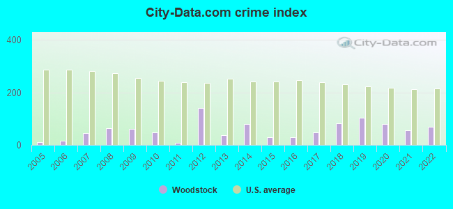
Crime rate in Woodstock detailed stats: murders, rapes, robberies, assaults, burglaries, thefts, arson
Full-time law enforcement employees in 2021, including police officers: 6 (5 officers - 5 male; 0 female).
| Officers per 1,000 residents here: | 1.72 |
| Vermont average: | 1.69 |
 Recent articles from our blog. Our writers, many of them Ph.D. graduates or candidates, create easy-to-read articles on a wide variety of topics.

 | Woodstock Winter vacation questions (19 replies) |
| Life in Woodstock (37 replies) |
| Brattleboro murder (58 replies) |
| NPR Brave Little State Why Do People Leave Vermont (83 replies) |
| Woodstock VT / Hanover Area (6 replies) |
| Southern Vermont Retirement Advice! Thank you! (22 replies) |
Latest news from Woodstock, VT collected exclusively by city-data.com from local newspapers, TV, and radio stations
Ancestries: English (22.1%), Irish (14.7%), German (11.7%), French Canadian (8.7%), American (4.1%), European (4.1%).
Current Local Time: EST time zone
Incorporated in 1837
Elevation: 705 feet
Land area: 1.03 square miles.
Population density: 908 people per square mile (low).
78 residents are foreign born (3.9% Europe, 1.3% Asia, 1.3% North America, 0.9% Oceania).
| This village: | 7.5% |
| Vermont: | 4.4% |
Median real estate property taxes paid for housing units with mortgages in 2022: $9,808 (1.4%)
Median real estate property taxes paid for housing units with no mortgage in 2022: $9,931 (1.4%)
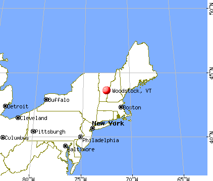
Nearest city with pop. 50,000+: Manchester, NH  (69.4 miles , pop. 107,006).
Nearest city with pop. 200,000+: Boston, MA (115.5 miles , pop. 589,141).
Nearest city with pop. 1,000,000+: Bronx, NY (204.2 miles , pop. 1,332,650).
Nearest cities:
), ), ), ), ), ), )Latitude: 43.62 N, Longitude: 72.52 W
Area code: 802
Woodstock tourist attractions:
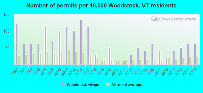
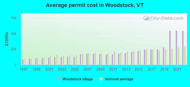
Single-family new house construction building permits:
- 2022: 6 buildings, average cost: $550,000
- 2021: 6 buildings, average cost: $550,000
- 2020: 5 buildings, average cost: $550,000
- 2019: 4 buildings, average cost: $282,200
- 2018: 2 buildings, average cost: $249,800
- 2017: 4 buildings, average cost: $248,100
- 2016: 6 buildings, average cost: $246,000
- 2015: 4 buildings, average cost: $226,800
- 2014: 5 buildings, average cost: $211,200
- 2013: 3 buildings, average cost: $193,300
- 2012: 1 building, cost: $184,000
- 2011: 1 building, cost: $172,800
- 2010: 5 buildings, average cost: $165,900
- 2009: 1 building, cost: $178,900
- 2008: 3 buildings, average cost: $182,400
- 2007: 11 buildings, average cost: $181,200
- 2006: 13 buildings, average cost: $171,000
- 2005: 10 buildings, average cost: $132,800
- 2004: 11 buildings, average cost: $132,800
- 2003: 10 buildings, average cost: $132,800
- 2002: 7 buildings, average cost: $130,700
- 2001: 11 buildings, average cost: $121,400
- 2000: 6 buildings, average cost: $118,000
- 1999: 6 buildings, average cost: $109,200
- 1998: 6 buildings, average cost: $101,700
- 1997: 12 buildings, average cost: $91,700
| Here: | 1.9% |
| Vermont: | 2.0% |
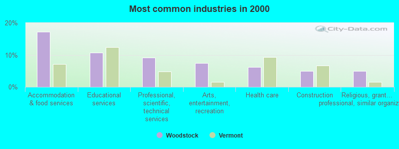
- Accommodation & food services (17.3%)
- Educational services (10.7%)
- Professional, scientific, technical services (9.1%)
- Arts, entertainment, recreation (7.5%)
- Health care (6.1%)
- Construction (5.0%)
- Religious, grantmaking, civic, professional, similar organizations (5.0%)
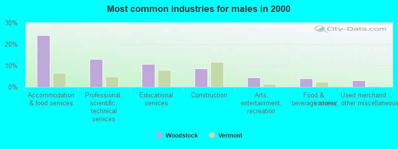
- Accommodation & food services (24.1%)
- Professional, scientific, technical services (12.9%)
- Educational services (10.8%)
- Construction (8.6%)
- Arts, entertainment, recreation (4.3%)
- Food & beverage stores (3.9%)
- Used merchandise, gift, novelty, souvenir, other miscellaneous stores (3.0%)
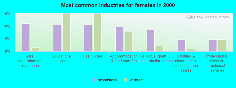
- Arts, entertainment, recreation (11.1%)
- Educational services (10.6%)
- Health care (10.6%)
- Accommodation & food services (9.6%)
- Religious, grantmaking, civic, professional, similar organizations (8.7%)
- Clothing & accessories, including shoe, stores (4.8%)
- Professional, scientific, technical services (4.8%)
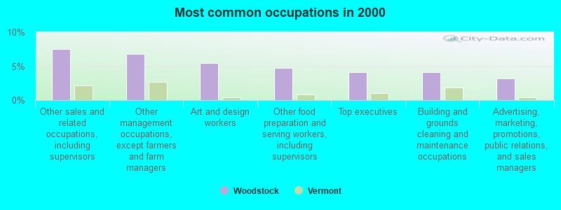
- Other sales and related occupations, including supervisors (7.5%)
- Other management occupations, except farmers and farm managers (6.8%)
- Art and design workers (5.5%)
- Other food preparation and serving workers, including supervisors (4.8%)
- Top executives (4.1%)
- Building and grounds cleaning and maintenance occupations (4.1%)
- Advertising, marketing, promotions, public relations, and sales managers (3.2%)
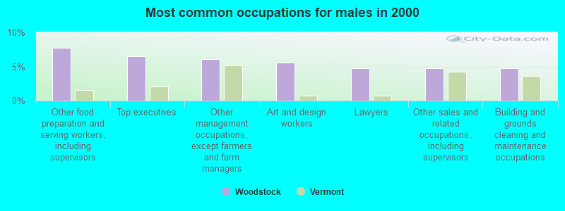
- Other food preparation and serving workers, including supervisors (7.8%)
- Top executives (6.5%)
- Other management occupations, except farmers and farm managers (6.0%)
- Art and design workers (5.6%)
- Lawyers (4.7%)
- Other sales and related occupations, including supervisors (4.7%)
- Building and grounds cleaning and maintenance occupations (4.7%)
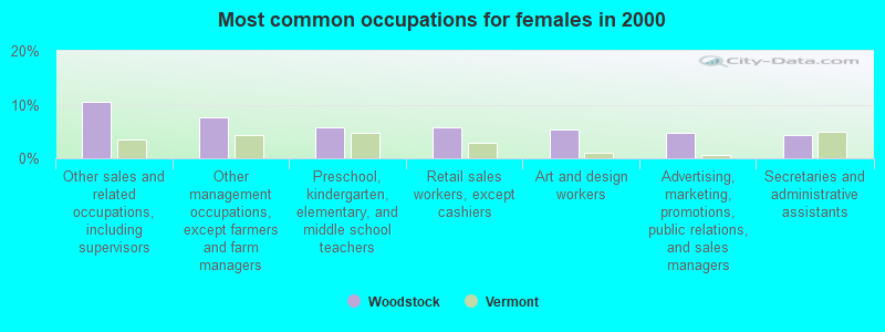
- Other sales and related occupations, including supervisors (10.6%)
- Other management occupations, except farmers and farm managers (7.7%)
- Preschool, kindergarten, elementary, and middle school teachers (5.8%)
- Retail sales workers, except cashiers (5.8%)
- Art and design workers (5.3%)
- Advertising, marketing, promotions, public relations, and sales managers (4.8%)
- Secretaries and administrative assistants (4.3%)
Average climate in Woodstock, Vermont
Based on data reported by over 4,000 weather stations


(lower is better)
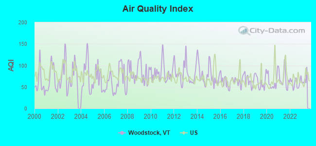
Air Quality Index (AQI) level in 2022 was 59.9. This is better than average.
| City: | 59.9 |
| U.S.: | 72.6 |
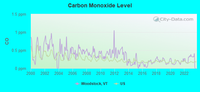
Carbon Monoxide (CO) [ppm] level in 2022 was 0.251. This is about average. Closest monitor was 23.3 miles away from the city center.
| City: | 0.251 |
| U.S.: | 0.251 |
Nitrogen Dioxide (NO2) [ppb] level in 2022 was 6.51. This is worse than average. Closest monitor was 23.3 miles away from the city center.
| City: | 6.51 |
| U.S.: | 5.11 |
Sulfur Dioxide (SO2) [ppb] level in 2022 was 0.299. This is significantly better than average. Closest monitor was 20.1 miles away from the city center.
| City: | 0.299 |
| U.S.: | 1.515 |
Ozone [ppb] level in 2022 was 25.0. This is better than average. Closest monitor was 10.2 miles away from the city center.
| City: | 25.0 |
| U.S.: | 33.3 |
Particulate Matter (PM2.5) [µg/m3] level in 2022 was 5.82. This is better than average. Closest monitor was 10.4 miles away from the city center.
| City: | 5.82 |
| U.S.: | 8.11 |
Tornado activity:
Woodstock-area historical tornado activity is slightly above Vermont state average. It is 66% smaller than the overall U.S. average.
On 8/20/1968, a category F3 (max. wind speeds 158-206 mph) tornado 38.9 miles away from the Woodstock village center injured one person and caused between $5000 and $50,000 in damages.
On 10/24/1955, a category F2 (max. wind speeds 113-157 mph) tornado 17.6 miles away from the village center caused between $5000 and $50,000 in damages.
Earthquake activity:
Woodstock-area historical earthquake activity is significantly above Vermont state average. It is 70% smaller than the overall U.S. average.On 4/20/2002 at 10:50:47, a magnitude 5.3 (5.3 ML, Depth: 3.0 mi, Class: Moderate, Intensity: VI - VII) earthquake occurred 85.0 miles away from Woodstock center
On 10/7/1983 at 10:18:46, a magnitude 5.3 (5.1 MB, 5.3 LG, 5.1 ML) earthquake occurred 93.9 miles away from the city center
On 4/20/2002 at 10:50:47, a magnitude 5.2 (5.2 MB, 4.2 MS, 5.2 MW, 5.0 MW) earthquake occurred 84.4 miles away from Woodstock center
On 1/19/1982 at 00:14:42, a magnitude 4.7 (4.5 MB, 4.7 MD, 4.5 LG, Class: Light, Intensity: IV - V) earthquake occurred 46.8 miles away from the city center
On 10/16/2012 at 23:12:25, a magnitude 4.7 (4.7 ML, Depth: 10.0 mi) earthquake occurred 93.2 miles away from the city center
On 6/16/1995 at 12:13:11, a magnitude 3.8 (3.8 LG, Depth: 3.1 mi, Class: Light, Intensity: II - III) earthquake occurred 54.8 miles away from Woodstock center
Magnitude types: regional Lg-wave magnitude (LG), body-wave magnitude (MB), duration magnitude (MD), local magnitude (ML), surface-wave magnitude (MS), moment magnitude (MW)
Natural disasters:
The number of natural disasters in Windsor County (20) is greater than the US average (15).Major Disasters (Presidential) Declared: 16
Emergencies Declared: 2
Causes of natural disasters: Floods: 14, Storms: 13, Tropical Storms: 2, Heavy Rain: 1, Hurricane: 1, Ice Storm: 1, Landslide: 1, Snowstorm: 1, Wind: 1, Winter Storm: 1 (Note: some incidents may be assigned to more than one category).

Hospitals and medical centers near Woodstock:
- WHITE RIVER JCT VA MEDICAL CENTER (Hospital, Acute Care - Veterans Administration, about 10 miles away; WHITE RIVER JUNCTION, VT)
- BROOKSIDE HEALTH AND REHABILITATION (Nursing Home, about 11 miles away; WHITE RIVER JUNCTION, VT)
- MT ASCUTNEY HOSPITAL Critical Access Hospitals (about 11 miles away; WINDSOR, VT)
- VNA AND HOSPICE OF VERMONT AND NH (Hospital, about 12 miles away; WHITE RIVER JUNCTION, VT)
- HANOVER TERRACE HEALTHCARE (Nursing Home, about 14 miles away; HANOVER, NH)
- CEDAR HILL HEALTH CARE CENTER (Nursing Home, about 15 miles away; WINDSOR, VT)
- FRESENIUS MEDICAL CARE OF LEBANON (Dialysis Facility, about 15 miles away; LEBANON, NH)
Amtrak stations near Woodstock:
- 11 miles: WHITE RIVER JUNCTION (RAILROAD ROW) . Services: ticket office, fully wheelchair accessible, enclosed waiting area, public restrooms, public payphones, free short-term parking, paid long-term parking, call for car rental service, call for taxi service, public transit connection.
- 12 miles: WINDSOR-MOUNT ASCUTNEY (WINDSOR, DEPOT AVE.) . Services: public payphones, free short-term parking, free long-term parking, call for car rental service, intercity bus service.
- 15 miles: KILLINGTON (RTE 4) - Seasonal Bus Station . Services: fully wheelchair accessible, enclosed waiting area, public payphones, snack bar, free short-term parking, call for car rental service, call for taxi service, public transit connection.
Colleges/universities with over 2000 students nearest to Woodstock:
- Dartmouth College (about 13 miles; Hanover, NH; Full-time enrollment: 6,030)
- Castleton State College (about 34 miles; Castleton, VT; FT enrollment: 2,079)
- Norwich University (about 37 miles; Northfield, VT; FT enrollment: 4,221)
- Middlebury College (about 43 miles; Middlebury, VT; FT enrollment: 3,077)
- Plymouth State University (about 43 miles; Plymouth, NH; FT enrollment: 4,838)
- Keene State College (about 50 miles; Keene, NH; FT enrollment: 5,098)
- NHTI-Concord's Community College (about 57 miles; Concord, NH; FT enrollment: 2,865)
Public high school in Woodstock:
- WOODSTOCK SENIOR UHSD #4 (Students: 422, Location: 496-1 WOODSTOCK ROAD, Grades: 9-12)
Public elementary/middle schools in Woodstock:
- WOODSTOCK UNION MIDDLE SCHOOL (Students: 208, Location: 496-1 WOODSTOCK ROAD, Grades: 7-8)
- WOODSTOCK ELEMENTARY SCHOOL (Students: 191, Location: 15 SOUTH STREET, Grades: PK-6)
Points of interest:
Notable locations in Woodstock: Frost Mill (A), Woodstock Town Hall (B), Woodstock Historical Society Building (C), Woodstock Community Recreation Center (D), Woodstock Community Correctional Center Library (E), Windsor County Courthouse (F), Norman Williams Public Library (G), Masonic Temple (H), Little Theatre (I), John Cotton Dana Library (J), Daughters of the American Revolution Historic House and Museum (K), Dana House Museum (L), American Legion House (M). Display/hide their locations on the map
Churches in Woodstock include: Saint James Episcopal Church (A), Woodstock Church of Christ (B), First Congregational Church (C), First Church of Christ Scientist (D), North Chapel (E), Our Lady of the Snows Roman Catholic Church (F). Display/hide their locations on the map
Cemetery: River Street Cemetery (1). Display/hide its location on the map
Streams, rivers, and creeks: Kedron Brook (A). Display/hide its location on the map
Parks in Woodstock include: Faulknet Park (1), The Green (2), Tribou Park (3), Vail Field (4), Woodstock Village Historic District (5), Billings Park and Trails (6), Billings Farm Museum (7). Display/hide their locations on the map
Tourist attractions: Billings Farm & Museum (River Road), Woodstock Historical Society (Cultural Attractions- Events- & Facilities; 26 Elm Street), Bike Vermont (Tours & Charters; 52 Pleasant Street).
Hotels: Winslow House (38 Route 4 West), Braeside Motel (P.O. Box 411), The Woodbridge Inn of Woodstock (546 Woodstock Road), Woodstock Inn & Resort (14 The Green), Shire Motel (46 Pleasant Street), Union Arena Inc (496 Woodstock Road), Applebutter Inn Bed and Breakfast (Happy Valley Road).
Court: Vermont State - Courts- Superior Courts- Windsor Superior (12 The Green).
Birthplace of: Keegan Bradley - Professional golfer, Joseph A. Mower - Union Army general, Sylvester Churchill - Inspector General of the Army, Benjamin Tyler Henry - Inventor, Fred C. Ainsworth - Surgeon in the Army who rose to Adjutant General.
Drinking water stations with addresses in Woodstock and their reported violations in the past:
WOODSTOCK AQUEDUCT CO (Population served: 2,473, Groundwater):Past monitoring violations:SUNRISE COMMUNITY WATER SYSTEM (Address: 1377 COX DIST RD , Population served: 829, Groundwater):
- Monitoring and Reporting (DBP) - Between OCT-2009 and DEC-2009, Contaminant: Chlorine. Follow-up actions: St Public Notif requested (MAR-01-2010), St Formal NOV issued (MAR-01-2010), St Public Notif received (JUN-29-2010), St Compliance achieved (MAR-17-2011)
- One minor monitoring violation
Past monitoring violations:SUICIDE SIX SKI AREA (Address: 2030 DEERBROOK WAY , Population served: 339, Groundwater):
- One routine major monitoring violation
- 3 regular monitoring violations
Past monitoring violations:WOODSTOCK INN & RESORT`S RACQUET & FITNE (Address: 2030 DEERBROOK WAY , Population served: 100, Groundwater):
- One routine major monitoring violation
Past health violations:WOODBRIDGE COFFEE HOUSE (Address: 5763 WEST WOODSTOCK RD , Population served: 52, Groundwater):Past monitoring violations:
- MCL, Monthly (TCR) - In SEP-2009, Contaminant: Coliform. Follow-up actions: St Tech Assistance Visit (SEP-16-2009), St Formal NOV issued (SEP-16-2009), St Public Notif requested (SEP-16-2009), St Boil Water Order (SEP-16-2009), St Compliance achieved (NOV-18-2010)
- MCL, Monthly (TCR) - In JUL-2009, Contaminant: Coliform. Follow-up actions: St Tech Assistance Visit (JUL-14-2009), St Formal NOV issued (JUL-14-2009), St Boil Water Order (JUL-14-2009), St Public Notif requested (JUL-14-2009), St Public Notif received (OCT-02-2009), St Compliance achieved (NOV-18-2010)
- MCL, Monthly (TCR) - Between JUL-2006 and SEP-2006, Contaminant: Coliform. Follow-up actions: St Tech Assistance Visit (AUG-02-2006), St Boil Water Order (AUG-02-2006), St Public Notif requested (AUG-02-2006), St Formal NOV issued (AUG-02-2006), St Compliance achieved (AUG-10-2011)
- Monitoring, Repeat Major (TCR) - Between JAN-2010 and MAR-2010, Contaminant: Coliform (TCR). Follow-up actions: St Public Notif requested (APR-26-2010), St Formal NOV issued (APR-26-2010), St Public Notif received (MAY-07-2010), St Compliance achieved (NOV-18-2010)
- 2 routine major monitoring violations
- One minor monitoring violation
Past health violations:WILD APPLE LIMITED PARTNERSHIP (Address: 2513 WEST WOODSTOCK RD , Population served: 50, Groundwater):Past monitoring violations:
- MCL, Acute (TCR) - In JUL-2009, Contaminant: Coliform. Follow-up actions: St Tech Assistance Visit (JUL-14-2009), St Formal NOV issued (JUL-14-2009), St Public Notif requested (JUL-14-2009), St Boil Water Order (JUL-14-2009), St Compliance achieved (SEP-27-2010)
- Monitoring, Source Water (GWR) - In JUL-13-2012, Contaminant: E. COLI. Follow-up actions: St Formal NOV issued (AUG-28-2012), St Public Notif requested (AUG-28-2012)
- Monitoring, Repeat Major (TCR) - In SEP-2009, Contaminant: Coliform (TCR). Follow-up actions: St Public Notif requested (NOV-02-2009), St Formal NOV issued (NOV-02-2009), St Compliance achieved (SEP-27-2010)
- Monitoring, Repeat Major (TCR) - Between APR-2009 and JUN-2009, Contaminant: Coliform (TCR). Follow-up actions: St Public Notif requested (JUL-23-2009), St Formal NOV issued (JUL-23-2009), St Compliance achieved (SEP-27-2010)
- 18 routine major monitoring violations
- 3 minor monitoring violations
- One regular monitoring violation
Past health violations:LINCOLN CORNER (Address: 2 LINCOLN CORNERS , Population served: 47, Groundwater):Past monitoring violations:
- MCL, Monthly (TCR) - In MAR-2006, Contaminant: Coliform. Follow-up actions: St Public Notif requested (MAR-30-2006), St Formal NOV issued (MAR-30-2006), St Compliance achieved (JAN-29-2010)
- MCL, Monthly (TCR) - In DEC-2005, Contaminant: Coliform. Follow-up actions: St Tech Assistance Visit (DEC-16-2005), St Boil Water Order (DEC-16-2005), St Public Notif requested (DEC-16-2005), St Formal NOV issued (DEC-16-2005), St Compliance achieved (JAN-29-2010)
- MCL, Monthly (TCR) - In NOV-2005, Contaminant: Coliform. Follow-up actions: St Tech Assistance Visit (NOV-10-2005), St Boil Water Order (NOV-10-2005), St Public Notif requested (NOV-10-2005), St Formal NOV issued (NOV-10-2005), St Compliance achieved (JAN-29-2010)
- MCL, Monthly (TCR) - In OCT-2005, Contaminant: Coliform. Follow-up actions: St Tech Assistance Visit (OCT-27-2005), St Boil Water Order (OCT-27-2005), St Public Notif requested (OCT-27-2005), St Formal NOV issued (OCT-27-2005), St Compliance achieved (JAN-29-2010)
- MCL, Monthly (TCR) - In SEP-2005, Contaminant: Coliform. Follow-up actions: St Formal NOV issued (OCT-10-2005), St Boil Water Order (OCT-10-2005), St Tech Assistance Visit (OCT-10-2005), St Public Notif requested (OCT-10-2005), St Compliance achieved (JAN-29-2010)
- MCL, Monthly (TCR) - Between JUL-2005 and SEP-2005, Contaminant: Coliform. Follow-up actions: St Boil Water Order (AUG-23-2005), St Public Notif requested (AUG-23-2005), St Tech Assistance Visit (AUG-23-2005), St Violation/Reminder Notice (AUG-23-2005), St Public Notif received (AUG-31-2005), St Compliance achieved (JAN-29-2010)
- One regular monitoring violation
Past monitoring violations:OTTAUQUECHEE MOTEL (Address: 4324 WEST WOODSTOCK RD , Population served: 43, Groundwater):
- One regular monitoring violation
Past health violations:Past monitoring violations:
- MCL, Monthly (TCR) - In DEC-2013, Contaminant: Coliform. Follow-up actions: St Tech Assistance Visit (JAN-03-2014), St Formal NOV issued (JAN-03-2014), St Boil Water Order (JAN-03-2014), St Public Notif requested (JAN-03-2014), St Public Notif received (APR-01-2014), St Compliance achieved (MAY-16-2014)
- Monitoring, Source Water (GWR) - In DEC-27-2013, Contaminant: E. COLI. Follow-up actions: St Public Notif requested (JAN-17-2014), St Formal NOV issued (JAN-17-2014), St Compliance achieved (MAY-16-2014)
- Monitoring, Repeat Major (TCR) - Between OCT-2013 and DEC-2013, Contaminant: Coliform (TCR). Follow-up actions: St Public Notif requested (JAN-17-2014), St Formal NOV issued (JAN-17-2014), St Compliance achieved (MAY-16-2014)
- 5 routine major monitoring violations
- 2 regular monitoring violations
| This village: | 2.0 people |
| Vermont: | 2.3 people |
| This village: | 50.6% |
| Whole state: | 62.5% |
| This village: | 6.1% |
| Whole state: | 9.2% |
Likely homosexual households (counted as self-reported same-sex unmarried-partner households)
- Lesbian couples: 0.7% of all households
- Gay men: 1.1% of all households
13 people in nursing facilities/skilled-nursing facilities in 2010
People in group quarters in Woodstock in 2000:
- 71 people in state prisons
- 23 people in other group homes
- 11 people in nursing homes
Banks with branches in Woodstock (2011 data):
- Lake Sunapee Bank, FSB: West Woodstock Branch at Route 4 West, branch established on 2001/02/13; Woodstock Branch at One Bond Street, branch established on 1989/11/14. Info updated 2011/07/21: Bank assets: $1,040.6 mil, Deposits: $808.6 mil, headquarters in Newport, NH, positive income, Mortgage Lending Specialization, 27 total offices
- TD Bank, National Association: Woodstock Branch at 429 Woodstock Road, branch established on 1979/04/10; Woodstock Branch at 21 Elm Street, branch established on 1865/01/01. Info updated 2010/10/04: Bank assets: $188,912.6 mil, Deposits: $153,149.8 mil, headquarters in Wilmington, DE, positive income, 1314 total offices, Holding Company: Toronto-Dominion Bank, The
- Mascoma Savings Bank: Woodstock Branch at 448 Woodstock Road, branch established on 2002/09/17. Info updated 2011/07/21: Bank assets: $990.7 mil, Deposits: $719.7 mil, headquarters in Lebanon, NH, positive income, Commercial Lending Specialization, 18 total offices
- People's United Bank: Woodstock Branch at 2 The Green, branch established on 1938/07/14. Info updated 2012/02/16: Bank assets: $27,319.3 mil, Deposits: $20,835.4 mil, headquarters in Bridgeport, CT, positive income, Commercial Lending Specialization, 374 total offices
- RBS Citizens, National Association: Woodstock Branch at 431 Woodstock Road, branch established on 1980/02/04. Info updated 2007/09/19: Bank assets: $106,940.6 mil, Deposits: $75,690.2 mil, headquarters in Providence, RI, positive income, 1135 total offices, Holding Company: Uk Financial Investments Limited
For population 15 years and over in Woodstock:
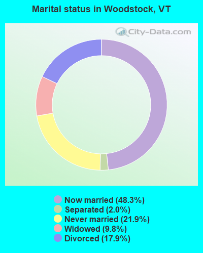
- Never married: 21.9%
- Now married: 48.3%
- Separated: 2.0%
- Widowed: 9.8%
- Divorced: 17.9%
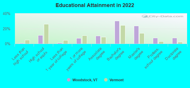
For population 25 years and over in Woodstock:
- High school or higher: 99.1%
- Bachelor's degree or higher: 66.8%
- Graduate or professional degree: 35.7%
- Unemployed: 2.9%
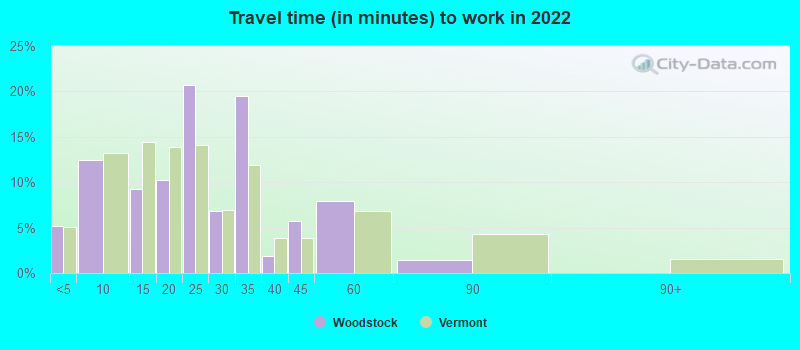
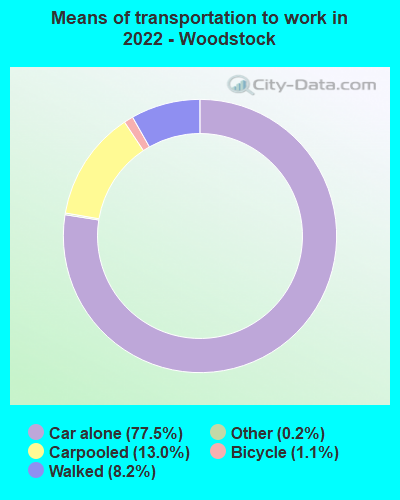
- Mean travel time to work (commute): 19.4 minutes
| Here: | 9.4 |
| Vermont average: | 10.8 |
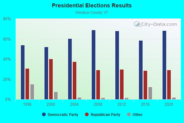
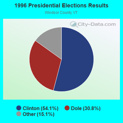
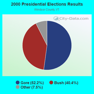
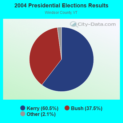
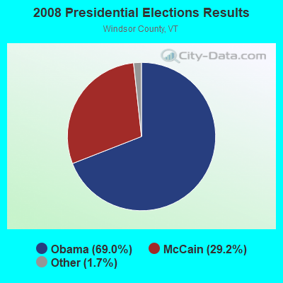
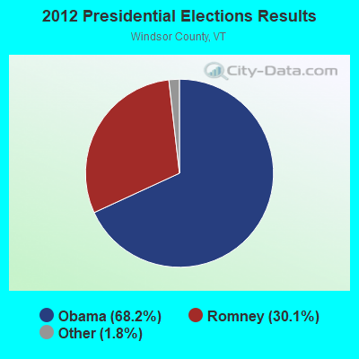
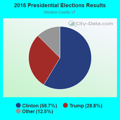
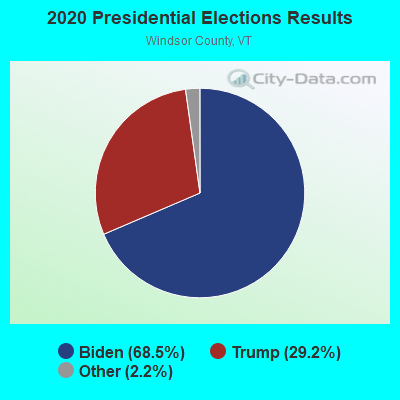
Graphs represent county-level data. Detailed 2008 Election Results
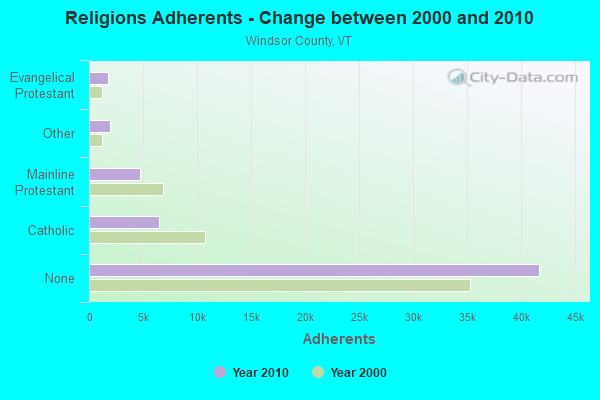
Religion statistics for Woodstock, VT (based on Windsor County data)
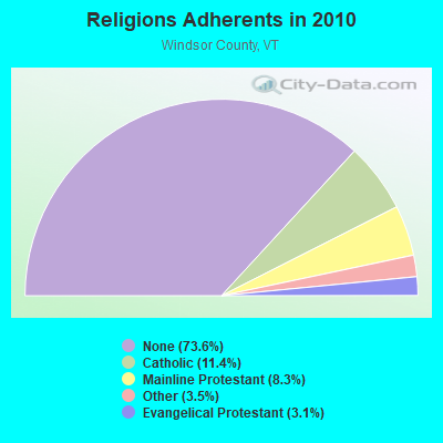
| Religion | Adherents | Congregations |
|---|---|---|
| Catholic | 6,485 | 10 |
| Mainline Protestant | 4,700 | 45 |
| Other | 1,964 | 17 |
| Evangelical Protestant | 1,750 | 21 |
| Orthodox | 55 | 1 |
| None | 41,716 | - |
Food Environment Statistics:
| This county: | 4.93 / 10,000 pop. |
| Vermont: | 3.84 / 10,000 pop. |
| This county: | 1.23 / 10,000 pop. |
| Vermont: | 1.95 / 10,000 pop. |
| This county: | 7.93 / 10,000 pop. |
| Vermont: | 6.40 / 10,000 pop. |
| This county: | 14.97 / 10,000 pop. |
| Vermont: | 11.52 / 10,000 pop. |
| Here: | 7.1% |
| Vermont: | 6.8% |
| This county: | 22.8% |
| Vermont: | 22.3% |
| Windsor County: | 9.7% |
| Vermont: | 13.3% |
Health and Nutrition:
| Here: | 55.6% |
| Vermont: | 52.9% |
| Woodstock: | 55.7% |
| Vermont: | 51.9% |
| Here: | 28.4 |
| Vermont: | 28.4 |
| Woodstock: | 18.5% |
| Vermont: | 21.2% |
| Here: | 11.4% |
| State: | 8.8% |
| This city: | 7.0 |
| Vermont: | 6.9 |
| This city: | 41.0% |
| Vermont: | 34.9% |
| Woodstock: | 60.2% |
| Vermont: | 59.7% |
| Here: | 80.0% |
| Vermont: | 79.6% |
More about Health and Nutrition of Woodstock, VT Residents
| Local government employment and payroll (March 2022) | |||||
| Function | Full-time employees | Monthly full-time payroll | Average yearly full-time wage | Part-time employees | Monthly part-time payroll |
|---|---|---|---|---|---|
| Streets and Highways | 7 | $33,507 | $57,441 | 0 | $0 |
| Other Government Administration | 4 | $28,564 | $85,692 | 0 | $0 |
| Sewerage | 4 | $20,757 | $62,271 | 0 | $0 |
| Health | 1 | $3,605 | $43,260 | 0 | $0 |
| Firefighters | 1 | $7,205 | $86,460 | 0 | $0 |
| Financial Administration | 1 | $5,646 | $67,752 | 1 | $1,222 |
| Other and Unallocable | 0 | $0 | 2 | $1,415 | |
| Totals for Government | 18 | $99,284 | $66,189 | 3 | $2,637 |
Woodstock government finances - Expenditure in 2017 (per resident):
- Current Operations - Police Protection: $763,000 ($812.57)
Regular Highways: $472,000 ($502.66)
Central Staff Services: $269,000 ($286.47)
General - Other: $248,000 ($264.11)
Financial Administration: $45,000 ($47.92)
Parks and Recreation: $8,000 ($8.52)
- Other Capital Outlay - Regular Highways: $38,000 ($40.47)
Police Protection: $27,000 ($28.75)
Woodstock government finances - Revenue in 2017 (per resident):
- Charges - Other: $336,000 ($357.83)
- Miscellaneous - Fines and Forfeits: $211,000 ($224.71)
Interest Earnings: $13,000 ($13.84)
General Revenue - Other: $1,000 ($1.06)
- State Intergovernmental - Highways: $291,000 ($309.90)
Other: $242,000 ($257.72)
- Tax - Property: $643,000 ($684.77)
Other License: $7,000 ($7.45)
Woodstock government finances - Cash and Securities in 2017 (per resident):
- Other Funds - Cash and Securities: $992,000 ($1056.44)
Businesses in Woodstock, VT
- FedEx: 2
- True Value: 1
Strongest AM radio stations in Woodstock:
- WNTK (1020 AM; 10 kW; NEWPORT, NH; Owner: KOOR COMMUNICATIONS, INC.)
- WNHV (910 AM; 1 kW; WHITE RIVER JUNCTION, VT)
- WNNZ (640 AM; 50 kW; WESTFIELD, MA; Owner: CLEAR CHANNEL BROADCASTING LICENSES, INC.)
- WGY (810 AM; 50 kW; SCHENECTADY, NY; Owner: CLEAR CHANNEL BROADCASTING LICENSES, INC.)
- WRKO (680 AM; 50 kW; BOSTON, MA; Owner: ENTERCOM BOSTON LICENSE, LLC)
- WSYB (1380 AM; 5 kW; RUTLAND, VT; Owner: CAPSTAR TX LIMITED PARTNERSHIP)
- WNBX (1480 AM; 5 kW; SPRINGFIELD, VT)
- WCRN (830 AM; 50 kW; WORCESTER, MA; Owner: CARTER BROADCASTING CORPORATION)
- WTSL (1400 AM; 1 kW; HANOVER, NH; Owner: CAPSTAR TX LIMITED PARTNERSHIP)
- WEEI (850 AM; 50 kW; BOSTON, MA; Owner: ENTERCOM BOSTON LICENSE, LLC)
- WDCR (1340 AM; 1 kW; HANOVER, NH; Owner: TRUSTEES OF DARTMOUTH COLLEGE)
- WCHP (760 AM; 35 kW; CHAMPLAIN, NY; Owner: CHAMPLAIN RADIO, INC.)
- WPTR (1540 AM; 50 kW; ALBANY, NY; Owner: KIMTRON, INC.)
Strongest FM radio stations in Woodstock:
- WMXR (93.9 FM; WOODSTOCK, VT; Owner: CLEAR CHANNEL BROADCASTING LICENSES, INC.)
- WVPR (89.5 FM; WINDSOR, VT; Owner: VERMONT PUBLIC RADIO)
- WJJR (98.1 FM; RUTLAND, VT; Owner: 6 JOHNSON ROAD LICENSES, INC.)
- WZRT (97.1 FM; RUTLAND, VT; Owner: CAPSTAR TX LIMITED PARTNERSHIP)
- WEBK (105.3 FM; KILLINGTON, VT; Owner: 6 JOHNSON ROAD LICENSES, INC.)
- WGLV (91.7 FM; WOODSTOCK, VT; Owner: CHRISTIAN MINISTRIES INC)
- WHDQ-FM1 (106.1 FM; RUTLAND, VT; Owner: GREAT NORTHERN RADIO, L.L.C.)
- WHDQ (106.1 FM; CLAREMONT, NH; Owner: GREAT NORTHERN RADIO, L.L.C.)
- WWOD (104.3 FM; HARTFORD, VT; Owner: FAMILY BROADCASTING, INC.)
- WXXK (100.5 FM; LEBANON, NH; Owner: CAPSTAR TX LIMITED PARTNERSHIP)
- WRJT (103.1 FM; ROYALTON, VT; Owner: LISBON COMMUNICATIONS, INC.)
- WEVH (91.3 FM; HANOVER, NH; Owner: NEW HAMPSHIRE PUBLIC RADIO INC)
- W232AP (94.3 FM; WHITE RIVER JUNCTION, VT; Owner: CLEAR CHANNEL BROADCASTING LICENSES, INC.)
- WVRR (101.7 FM; NEWPORT, NH; Owner: CAPSTAR TX LIMITED PARTNERSHIP)
- WJEN (94.5 FM; RUTLAND, VT; Owner: 6 JOHNSON ROAD LICENSES, INC.)
- WDEV-FM (96.1 FM; WARREN, VT; Owner: RADIO VERMONT, INC.)
- WEQX (102.7 FM; MANCHESTER, VT; Owner: NORTHSHIRE COMMUNICATIONS, INC.)
- WJAN (95.1 FM; SUNDERLAND, VT; Owner: 6 JOHNSON ROAD LICENSES, INC.)
- WEXP (101.5 FM; BRANDON, VT; Owner: VOX VERMONT, L.L.C.)
- WGXL (92.3 FM; HANOVER, NH; Owner: CAPSTAR TX LIMITED PARTNERSHIP)
TV broadcast stations around Woodstock:
- WVTA (Channel 41; WINDSOR, VT; Owner: VERMONT ETV, INC.)
- WNNE (Channel 31; HARTFORD, VT; Owner: HEARST-ARGYLE STATIONS, INC.)
- W17CI (Channel 17; CLAREMONT, NH; Owner: UPPER VALLEY BROADCASTING, LLC)
- W15BK (Channel 15; HANOVER, NH; Owner: UNIVERSITY OF NEW HAMPSHIRE)
- Woodstock, Vermont
- Fatal accident count26
- Vehicles involved in fatal accidents37
- Fatal accidents involving drunk persons:10
- Fatalities30
- Persons involved in fatal accidents53
- Pedestrians involved in fatal accidents2
- Vermont average
- Fatal accident count1909
- Vehicles involved in fatal accidents2668
- Fatal accidents involving drunk persons770
- Fatalities2150
- Persons involved in fatal accidents4634
- Pedestrians involved in fatal accidents98
- National Bridge Inventory (NBI) Statistics
- 28Number of bridges
- 180ft / 55.1mTotal length
- $9,814,000Total costs
- 50,810Total average daily traffic
- 2,609Total average daily truck traffic
- 53,354Total future (year 2027) average daily traffic
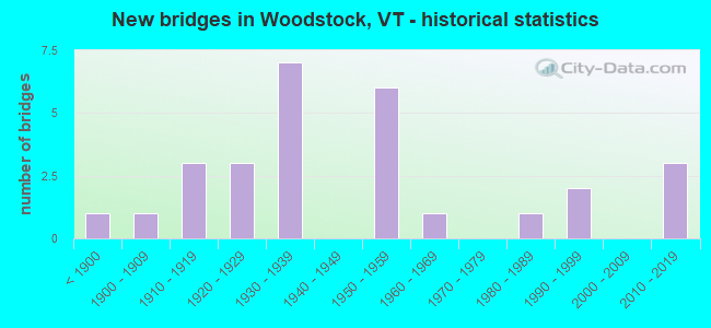
- New bridges - historical statistics
- 1Before 1900
- 11900-1909
- 31910-1919
- 31920-1929
- 71930-1939
- 61950-1959
- 11960-1969
- 11980-1989
- 21990-1999
- 32010-2019
FCC Registered Antenna Towers:
3- Edward G Roach, 893 Larry Curtis Road (Lat: 43.590722 Lon: -72.592861), Type: 22.8, Overall height: 21 m, Registrant: Sba Towers Ii LLC, Eroach@sbasite.Com, , Boca -Raton, Phone: (561) 995-7670
- Edward G Roach, 893 Larry Curtis Road (Lat: 43.590722 Lon: -72.592861), Type: 22.8, Overall height: 21 m, Registrant: Sba Towers Ii LLC, Eroach@sbasite.Com, , Boca -Raton, Phone: (561) 995-7670
- Edward G Roach, 893 Larry Curtis Road (Vt10980-A) (Lat: 43.590722 Lon: -72.592861), Type: 28.8, Structure height: 50027 m, Overall height: 21 m, Registrant: Sba Towers Ii LLC, Eroach@sbasite.Com, , Boca -Raton, Phone: (561) 995-7670
FCC Registered Broadcast Land Mobile Towers:
11 (See the full list of FCC Registered Broadcast Land Mobile Towers in Woodstock, VT)FCC Registered Microwave Towers:
2- BRIDGEWATER, 893 Larry Curtis Road (Vt10980-A) (Lat: 43.590722 Lon: -72.592861), Type: Mtower, Structure height: 21 m, Overall height: 28.8 m, Call Sign: WQTI397,
Assigned Frequencies: 953.950 MHz, 6345.49 MHz, 6345.49 MHz, 6345.49 MHz, 6345.49 MHz, 6345.49 MHz, 6345.49 MHz, 6345.49 MHz, 6345.49 MHz, 6345.49 MHz, 6345.49 MHz, Grant Date: 03/20/2024, Expiration Date: 02/10/2034, Certifier: Phillip T Chitwood, Registrant: Vermont Transco LLC, 366 Pinnacle Ridge Road, Rutland, VT 05701, Phone: (802) 772-3777, Email:
- Quechee-02, 235 Fairbanks Turn (Lat: 43.648889 Lon: -72.460528), Type: Mtower, Structure height: 27.4 m, Call Sign: WQVI909,
Assigned Frequencies: 11225.0 MHz, 11425.0 MHz, 11225.0 MHz, 11425.0 MHz, 11225.0 MHz, 11425.0 MHz, 11225.0 MHz, 11425.0 MHz, 11225.0 MHz, 11425.0 MHz... (+14 more), Grant Date: 02/26/2015, Expiration Date: 02/26/2025, Certifier: Fran Stocker, Registrant: Radyn, Inc, Silver Spring, MD 20914, Phone: (301) 493-5171, Fax: (301) 576-4553, Email:
FCC Registered Paging Towers:
1- 15 Slayton Terrace (Lat: 43.625500 Lon: -72.515194), Type: Tower, Structure height: 6.1 m, Overall height: 10.7 m, Call Sign: KDS417,
Assigned Frequencies: 152.030 MHz, Grant Date: 04/02/2019, Expiration Date: 04/01/2029, Certifier: Gerald W Blanchard, Registrant: Keller And Heckman LLP, 1001 G Street Nw, Suite 500 West, Washington, DC 20001, Phone: (202) 434-4100, Fax: (202) 434-4646, Email:
FCC Registered Amateur Radio Licenses:
18 (See the full list of FCC Registered Amateur Radio Licenses in Woodstock)FAA Registered Aircraft:
1- Aircraft: AERONCA 65-LA (Category: Land, Seats: 2, Weight: Up to 12,499 Pounds, Speed: 75 mph), Engine: LYCOMING 0-145B SERIES (65 HP) (Reciprocating)
N-Number: 24244, N24244, N-24244, Serial Number: L7119, Year manufactured: 1939, Airworthiness Date: 03/04/1957, Certificate Issue Date: 07/17/2019
Registrant (Individual): George P Jr Thomas, 73 South St, Woodstock, VT 05091
2002 - 2018 National Fire Incident Reporting System (NFIRS) incidents
- Fire incident types reported to NFIRS in Woodstock, VT
- 12664.6%Structure Fires
- 3819.5%Outside Fires
- 178.7%Mobile Property/Vehicle Fires
- 147.2%Other
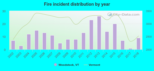 According to the data from the years 2002 - 2018 the average number of fires per year is 11. The highest number of fires - 26 took place in 2013, and the least - 1 in 2017. The data has a growing trend.
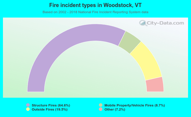 When looking into fire subcategories, the most reports belonged to: Structure Fires (64.6%), and Outside Fires (19.5%).
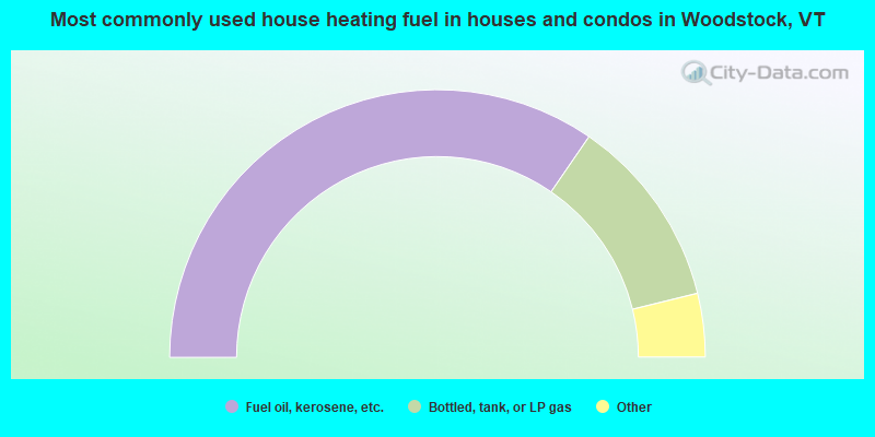
- 69.5%Fuel oil, kerosene, etc.
- 23.3%Bottled, tank, or LP gas
- 2.5%Utility gas
- 2.2%Electricity
- 1.8%Wood
- 0.7%Other fuel
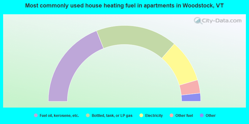
- 38.3%Fuel oil, kerosene, etc.
- 34.8%Bottled, tank, or LP gas
- 18.3%Electricity
- 5.7%Other fuel
- 1.7%Wood
- 1.3%No fuel used
Woodstock compared to Vermont state average:
- Median house value above state average.
- Unemployed percentage significantly below state average.
- Black race population percentage below state average.
- Hispanic race population percentage significantly below state average.
- Median age above state average.
- Foreign-born population percentage above state average.
- Length of stay since moving in significantly below state average.
- Number of rooms per house above state average.
- House age above state average.
- Number of college students significantly below state average.
- Percentage of population with a bachelor's degree or higher above state average.
Woodstock on our top lists:
- #57 on the list of "Top 101 cities with the most people born in other U.S. states (population 500+)"
- #39 on the list of "Top 101 counties with the highest percentage of residents that keep firearms around their homes"
- #40 on the list of "Top 101 counties with highest percentage of residents voting for Obama (Democrat) in the 2012 Presidential Election (pop. 50,000+)"
- #47 on the list of "Top 101 counties with the highest percentage of residents that smoked 100+ cigarettes in their lives"
- #54 on the list of "Top 101 counties with the lowest surface withdrawal of fresh water for public supply (pop. 50,000+)"
- #61 on the list of "Top 101 counties with the best general health status score of residents (1-5), 3 years of data"

|
|
Total of 34 patent applications in 2008-2024.