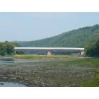
Cornish, New Hampshire

Submit your own pictures of this town and show them to the world
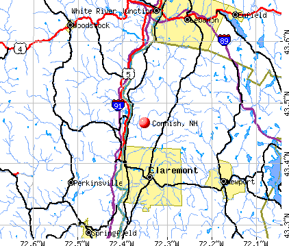
- OSM Map
- General Map
- Google Map
- MSN Map
Population change since 2000: -1.3%
 |
| Males: 821 | |
| Females: 819 |
| Median resident age: | 48.6 years |
| New Hampshire median age: | 43.9 years |
Zip codes: 03745.
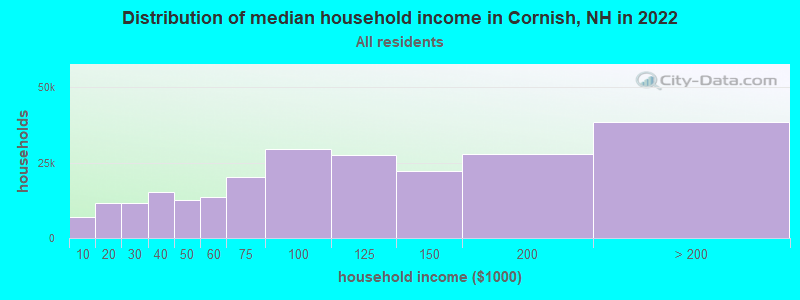
| Cornish: | $91,458 |
| NH: | $89,992 |
Estimated per capita income in 2022: $43,379 (it was $23,165 in 2000)
Cornish town income, earnings, and wages data
Estimated median house or condo value in 2022: $316,103 (it was $117,400 in 2000)
| Cornish: | $316,103 |
| NH: | $384,700 |
Mean prices in 2022: all housing units: $337,766; detached houses: $372,023; townhouses or other attached units: $454,943; in 2-unit structures: $245,522; in 3-to-4-unit structures: $240,260; in 5-or-more-unit structures: $222,243; mobile homes: $88,713
Detailed information about poverty and poor residents in Cornish, NH
Compare current foreclosures near Cornish, NH:
| Photo | Address | Area | Beds / Baths | Price | Details |
|---|---|---|---|---|---|

|
#1
Doe Hill Way
Woodstock, VT 05091
|
1,264 sq. feet
|
1 baths 1 beds |
$262,900
|
show details |

|
#2
S Main St
Newport, NH 03773
|
100 sq. feet
|
1 baths 1 beds |
$60,000
|
show details |

|
#3
W Terrace St
Claremont, NH 03743
|
988 sq. feet
|
1 baths 3 beds |
show details | |

|
#4
Elm St
Claremont, NH 03743
|
2,232 sq. feet
|
2 baths 4 beds |
show details | |

|
#5
S Koski Rd
Newport, NH 03773
|
1,596 sq. feet
|
2 baths 3 beds |
show details | |

|
#6
Elm St
Newport, NH 03773
|
2,029 sq. feet
|
2 baths 4 beds |
show details | |

|
#7
Ryder Corner Rd
Sunapee, NH 03782
|
1,248 sq. feet
|
1 baths 3 beds |
show details | |

|
#8
Old Springfield Rd
Charlestown, NH 03603
|
1,848 sq. feet
|
1 baths 4 beds |
show details | |

|
#9
James St
Charlestown, NH 03603
|
1,032 sq. feet
|
2 baths 2 beds |
show details | |

|
#10
Knights Hill Rd
New London, NH 03257
|
3,024 sq. feet
|
2 baths 4 beds |
show details |
| Photo | Address | Area | Beds / Baths | Price | Details |
|---|---|---|---|---|---|

|
#11
Morways Park
Charlestown, NH 03603
|
1,064 sq. feet
|
2 baths 2 beds |
show details | |

|
#12
Bank Street Ext
Lebanon, NH 03766
|
1,232 sq. feet
|
1 baths 4 beds |
show details | |

|
#13
Dodge Pl
Claremont, NH 03743
|
1,650 sq. feet
|
2 baths 3 beds |
show details | |

|
#14
Ryder Corner Rd
Sunapee, NH 03782
|
1,508 sq. feet
|
2 baths 3 beds |
show details | |

|
#15
Winter St W
West Lebanon, NH 03784
|
894 sq. feet
|
1 baths 2 beds |
show details | |

|
#16
Pine Grove St
Claremont, NH 03743
|
2,304 sq. feet
|
1 baths 3 beds |
show details | |

|
#17
Elm St
Claremont, NH 03743
|
2,176 sq. feet
|
2 baths 5 beds |
show details | |

|
#18
Orchard Rd
Enfield, NH 03748
|
1,056 sq. feet
|
2 baths 2 beds |
show details | |

|
#19
Byrd Ave
Claremont, NH 03743
|
1,904 sq. feet
|
1 baths 3 beds |
show details | |

|
#20
Renihan Mdws
Lebanon, NH 03766
|
- sq. feet
|
- baths - beds |
show details |
| Photo | Address | Area | Beds / Baths | Price | Details |
|---|---|---|---|---|---|

|
#21
Franklin St Frnt A
Claremont, NH 03743
|
- sq. feet
|
- baths - beds |
show details | |

|
#22
W Pleasant St
Claremont, NH 03743
|
- sq. feet
|
- baths - beds |
show details | |

|
#23
Westview Ter
Springfield, VT 05156
|
- sq. feet
|
- baths - beds |
show details | |

|
#24
Us Route 4, Unit 5
Enfield, NH 03748
|
- sq. feet
|
- baths - beds |
show details | |

|
#25
S Koski Rd
Newport, NH 03773
|
- sq. feet
|
- baths - beds |
show details | |

|
#26
S Main St Apt 2
White River Junction, VT 05001
|
- sq. feet
|
- baths - beds |
show details | |

|
#27
Bowman Rd
Springfield, NH 03284
|
- sq. feet
|
- baths - beds |
show details | |

|
#28
N Puckerbrush Rd
Reading, VT 05062
|
- sq. feet
|
- baths - beds |
show details | |

|
#29
Dawn Dr
White River Junction, VT 05001
|
- sq. feet
|
- baths - beds |
show details | |

|
#30
Dogwood Ln
Springfield, VT 05156
|
- sq. feet
|
- baths - beds |
show details |
| Photo | Address | Area | Beds / Baths | Price | Details |
|---|---|---|---|---|---|

|
#31
Blood Rd
Newport, NH 03773
|
- sq. feet
|
- baths - beds |
show details | |

|
#32
Roberts Rd
Springfield, VT 05156
|
- sq. feet
|
- baths - beds |
show details | |

|
#33
Bavier Ave
Windsor, VT 05089
|
- sq. feet
|
- baths - beds |
show details | |

|
#34
Taylor Dr
Springfield, VT 05156
|
- sq. feet
|
- baths - beds |
show details | |

|
#35
Downing Rd
Hanover, NH 03755
|
- sq. feet
|
- baths - beds |
show details | |

|
#36
Upper Falls Rd
Perkinsville, VT 05151
|
- sq. feet
|
- baths - beds |
show details | |

|
#37
Mill St
Cavendish, VT 05142
|
- sq. feet
|
- baths - beds |
show details | |

|
#38
Parkview St
Newport, NH 03773
|
- sq. feet
|
- baths - beds |
show details | |

|
Check over 1 million property listings on Foreclosure.com!
|
browse all offers | |||

- 1,58096.3%White alone
- 241.5%Two or more races
- 150.9%Hispanic
- 80.5%American Indian alone
- 60.4%Black alone
- 60.4%Asian alone
- 10.06%Other race alone
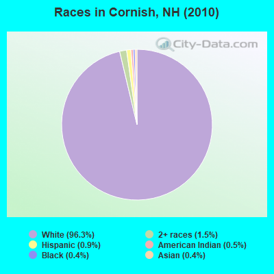
Races in Cornish detailed stats: ancestries, foreign born residents, place of birth
According to our research of New Hampshire and other state lists, there were 5 registered sex offenders living in Cornish, New Hampshire as of April 26, 2024.
The ratio of all residents to sex offenders in Cornish is 328 to 1.
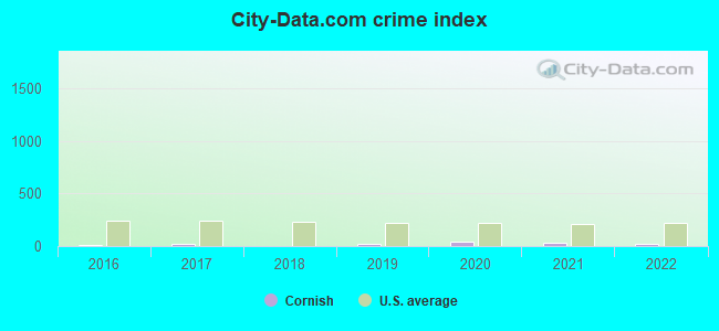
Type |
2016 |
2017 |
2018 |
2019 |
2020 |
2021 |
2022 |
|---|---|---|---|---|---|---|---|
| Murders (per 100,000) | 0 (0.0) | 0 (0.0) | 0 (0.0) | 0 (0.0) | 0 (0.0) | 0 (0.0) | 0 (0.0) |
| Rapes (per 100,000) | 0 (0.0) | 0 (0.0) | 0 (0.0) | 0 (0.0) | 0 (0.0) | 0 (0.0) | 0 (0.0) |
| Robberies (per 100,000) | 0 (0.0) | 0 (0.0) | 0 (0.0) | 0 (0.0) | 0 (0.0) | 0 (0.0) | 0 (0.0) |
| Assaults (per 100,000) | 0 (0.0) | 0 (0.0) | 0 (0.0) | 0 (0.0) | 0 (0.0) | 0 (0.0) | 0 (0.0) |
| Burglaries (per 100,000) | 2 (123.7) | 1 (62.0) | 0 (0.0) | 2 (123.2) | 2 (123.9) | 0 (0.0) | 0 (0.0) |
| Thefts (per 100,000) | 2 (123.7) | 2 (124.1) | 1 (61.7) | 5 (308.1) | 13 (805.5) | 11 (681.5) | 7 (421.9) |
| Auto thefts (per 100,000) | 0 (0.0) | 2 (124.1) | 0 (0.0) | 0 (0.0) | 1 (62.0) | 0 (0.0) | 0 (0.0) |
| Arson (per 100,000) | 0 (0.0) | 0 (0.0) | 0 (0.0) | 1 (61.6) | 0 (0.0) | 0 (0.0) | 0 (0.0) |
| City-Data.com crime index | 13.6 | 19.2 | 2.5 | 20.9 | 45.8 | 27.3 | 16.9 |
The City-Data.com crime index weighs serious crimes and violent crimes more heavily. Higher means more crime, U.S. average is 246.1. It adjusts for the number of visitors and daily workers commuting into cities.
Crime rate in Cornish detailed stats: murders, rapes, robberies, assaults, burglaries, thefts, arson
 Recent articles from our blog. Our writers, many of them Ph.D. graduates or candidates, create easy-to-read articles on a wide variety of topics.

 | First visit to NH (28 replies) |
| Commute from Keene to Claremont (20 replies) |
| So much to enjoy in my little State (8 replies) |
| Claremont, NH SOS!! (Long . . .) (53 replies) |
| Anyone live in the Eastman community? (20 replies) |
| Hello all! Would like responses from all people from NH! (42 replies) |
Latest news from Cornish, NH collected exclusively by city-data.com from local newspapers, TV, and radio stations
Ancestries: English (20.8%), Irish (12.4%), French (11.7%), German (11.3%), French Canadian (8.5%), United States (7.2%).
Current Local Time: EST time zone
Incorporated in 1765
Elevation: 610 feet
Land area: 42.1 square miles.
Population density: 39 people per square mile (very low).
41 residents are foreign born (1.1% Europe, 0.7% North America, 0.4% Asia, 0.3% Latin America).
| This town: | 2.5% |
| New Hampshire: | 4.4% |
| Cornish town: | 2.2% ($2,639) |
| New Hampshire: | 2.3% ($2,946) |
Nearest city with pop. 50,000+: Manchester, NH  (55.3 miles , pop. 107,006).
Nearest city with pop. 200,000+: Boston, MA (101.3 miles , pop. 589,141).
Nearest city with pop. 1,000,000+: Bronx, NY (198.8 miles , pop. 1,332,650).
Nearest cities:
), ), ), ), )Latitude: 43.48 N, Longitude: 72.32 W

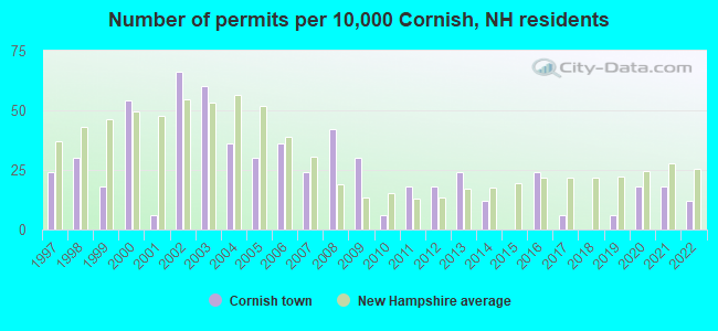
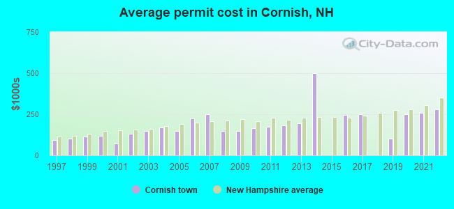
Single-family new house construction building permits:
- 2022: 2 buildings, average cost: $279,200
- 2021: 3 buildings, average cost: $259,200
- 2020: 3 buildings, average cost: $248,200
- 2019: 1 building, cost: $100,000
- 2017: 1 building, cost: $248,100
- 2016: 4 buildings, average cost: $246,000
- 2014: 2 buildings, average cost: $500,000
- 2013: 4 buildings, average cost: $193,300
- 2012: 3 buildings, average cost: $184,000
- 2011: 3 buildings, average cost: $172,800
- 2010: 1 building, cost: $165,900
- 2009: 5 buildings, average cost: $150,000
- 2008: 7 buildings, average cost: $150,000
- 2007: 4 buildings, average cost: $250,000
- 2006: 6 buildings, average cost: $225,000
- 2005: 5 buildings, average cost: $150,200
- 2004: 6 buildings, average cost: $170,000
- 2003: 10 buildings, average cost: $150,000
- 2002: 11 buildings, average cost: $130,700
- 2001: 1 building, cost: $70,000
- 2000: 9 buildings, average cost: $118,000
- 1999: 3 buildings, average cost: $116,000
- 1998: 5 buildings, average cost: $101,700
- 1997: 4 buildings, average cost: $91,700
| Here: | 2.1% |
| New Hampshire: | 2.5% |
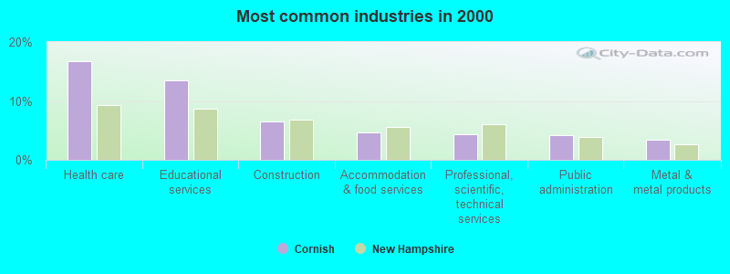
- Health care (16.8%)
- Educational services (13.5%)
- Construction (6.5%)
- Accommodation & food services (4.7%)
- Professional, scientific, technical services (4.4%)
- Public administration (4.1%)
- Metal & metal products (3.4%)
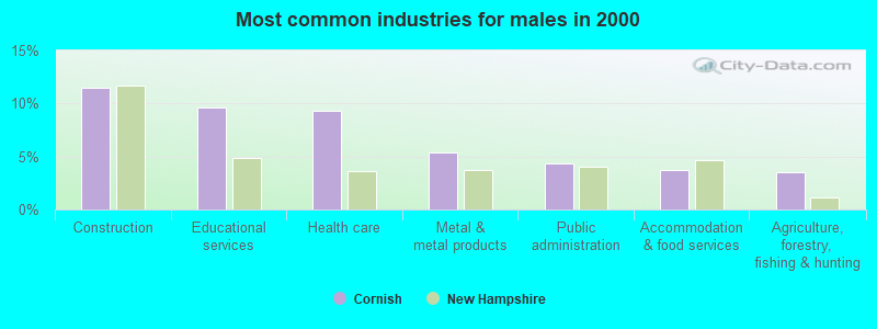
- Construction (11.5%)
- Educational services (9.7%)
- Health care (9.3%)
- Metal & metal products (5.3%)
- Public administration (4.3%)
- Accommodation & food services (3.7%)
- Agriculture, forestry, fishing & hunting (3.5%)
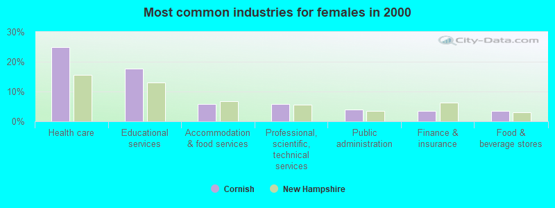
- Health care (24.8%)
- Educational services (17.6%)
- Accommodation & food services (5.7%)
- Professional, scientific, technical services (5.7%)
- Public administration (4.0%)
- Finance & insurance (3.5%)
- Food & beverage stores (3.5%)
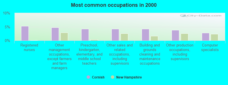
- Registered nurses (5.2%)
- Other management occupations, except farmers and farm managers (4.8%)
- Preschool, kindergarten, elementary, and middle school teachers (4.3%)
- Other sales and related occupations, including supervisors (4.3%)
- Building and grounds cleaning and maintenance occupations (4.3%)
- Other production occupations, including supervisors (3.8%)
- Computer specialists (2.8%)
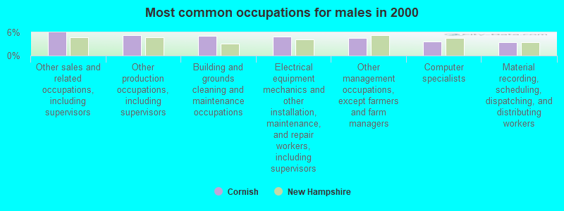
- Other sales and related occupations, including supervisors (6.0%)
- Other production occupations, including supervisors (5.3%)
- Building and grounds cleaning and maintenance occupations (5.1%)
- Electrical equipment mechanics and other installation, maintenance, and repair workers, including supervisors (4.9%)
- Other management occupations, except farmers and farm managers (4.5%)
- Computer specialists (3.7%)
- Material recording, scheduling, dispatching, and distributing workers (3.5%)
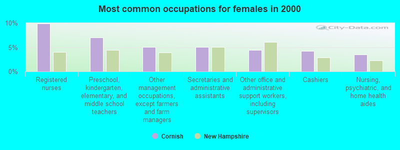
- Registered nurses (9.9%)
- Preschool, kindergarten, elementary, and middle school teachers (7.0%)
- Other management occupations, except farmers and farm managers (5.1%)
- Secretaries and administrative assistants (5.1%)
- Other office and administrative support workers, including supervisors (4.4%)
- Cashiers (4.2%)
- Nursing, psychiatric, and home health aides (3.5%)
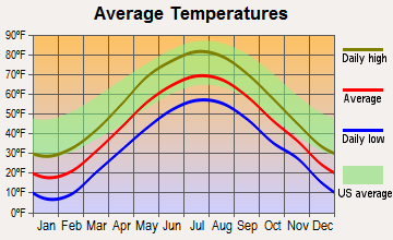
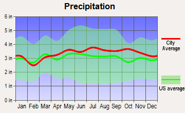
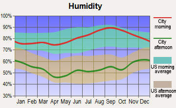
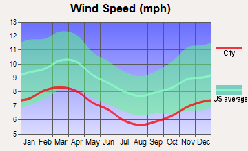
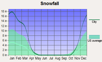
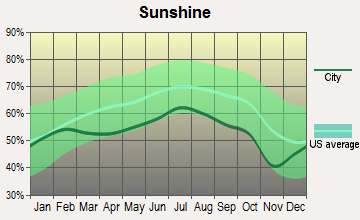
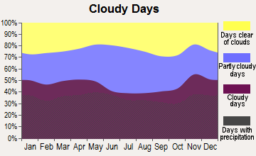
Average climate in Cornish, New Hampshire
Based on data reported by over 4,000 weather stations
(lower is better)
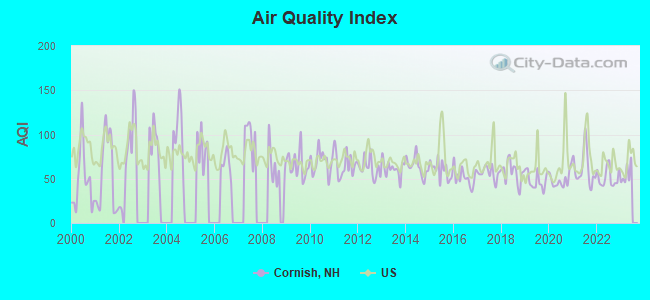
Air Quality Index (AQI) level in 2022 was 51.4. This is significantly better than average.
| City: | 51.4 |
| U.S.: | 72.6 |
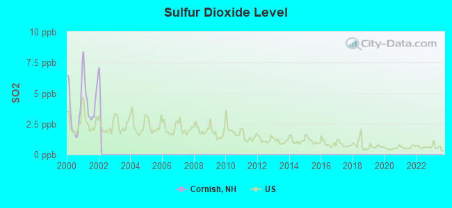
Sulfur Dioxide (SO2) [ppb] level in 2001 was 4.62. This is significantly worse than average. Closest monitor was 8.0 miles away from the city center.
| City: | 4.62 |
| U.S.: | 1.51 |

Ozone [ppb] level in 2022 was 25.3. This is better than average. Closest monitor was 3.6 miles away from the city center.
| City: | 25.3 |
| U.S.: | 33.3 |
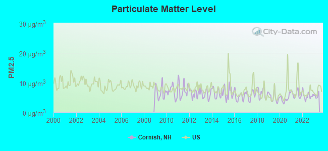
Particulate Matter (PM2.5) [µg/m3] level in 2022 was 5.54. This is significantly better than average. Closest monitor was 8.0 miles away from the city center.
| City: | 5.54 |
| U.S.: | 8.11 |
Tornado activity:
Cornish-area historical tornado activity is near New Hampshire state average. It is 57% smaller than the overall U.S. average.
On 8/20/1968, a category F3 (max. wind speeds 158-206 mph) tornado 35.8 miles away from the Cornish town center injured one person and caused between $5000 and $50,000 in damages.
On 7/9/1962, a category F2 (max. wind speeds 113-157 mph) tornado 10.3 miles away from the town center caused between $500 and $5000 in damages.
Earthquake activity:
Cornish-area historical earthquake activity is significantly above New Hampshire state average. It is 70% smaller than the overall U.S. average.On 4/20/2002 at 10:50:47, a magnitude 5.3 (5.3 ML, Depth: 3.0 mi, Class: Moderate, Intensity: VI - VII) earthquake occurred 99.2 miles away from the city center
On 10/7/1983 at 10:18:46, a magnitude 5.3 (5.1 MB, 5.3 LG, 5.1 ML) earthquake occurred 106.4 miles away from the city center
On 4/20/2002 at 10:50:47, a magnitude 5.2 (5.2 MB, 4.2 MS, 5.2 MW, 5.0 MW) earthquake occurred 98.6 miles away from Cornish center
On 1/19/1982 at 00:14:42, a magnitude 4.7 (4.5 MB, 4.7 MD, 4.5 LG, Class: Light, Intensity: IV - V) earthquake occurred 36.0 miles away from Cornish center
On 10/16/2012 at 23:12:25, a magnitude 4.7 (4.7 ML, Depth: 10.0 mi) earthquake occurred 83.7 miles away from the city center
On 6/16/1995 at 12:13:11, a magnitude 3.8 (3.8 LG, Depth: 3.1 mi, Class: Light, Intensity: II - III) earthquake occurred 59.3 miles away from the city center
Magnitude types: regional Lg-wave magnitude (LG), body-wave magnitude (MB), duration magnitude (MD), local magnitude (ML), surface-wave magnitude (MS), moment magnitude (MW)
Natural disasters:
The number of natural disasters in Sullivan County (28) is a lot greater than the US average (15).Major Disasters (Presidential) Declared: 18
Emergencies Declared: 9
Causes of natural disasters: Storms: 13, Floods: 12, Snows: 4, Winter Storms: 4, Hurricanes: 3, Blizzard: 1, Ice Storm: 1, Landslide: 1, Snowfall: 1, Snowstorm: 1, Tropical Storm: 1, Wind: 1, Other: 1 (Note: some incidents may be assigned to more than one category).
Hospitals and medical centers near Cornish:
- MT ASCUTNEY HOSPITAL Critical Access Hospitals (about 5 miles away; WINDSOR, VT)
- CEDAR HILL HEALTH CARE CENTER (Nursing Home, about 6 miles away; WINDSOR, VT)
- ELM WOOD CENTER AT CLAREMONT (Nursing Home, about 7 miles away; CLAREMONT, NH)
- VALLEY REGIONAL HOSPITAL Critical Access Hospitals (about 7 miles away; CLAREMONT, NH)
- CONNECTICUT VALLEY HOME CARE (Home Health Center, about 10 miles away; NEWPORT, NH)
- TRUSTING HANDS (Home Health Center, about 10 miles away; NEWPORT, NH)
- NEWPORT HOSPITAL (Hospital, about 11 miles away; NEWPORT, NH)
Amtrak stations near Cornish:
- 4 miles: WINDSOR-MOUNT ASCUTNEY (WINDSOR, DEPOT AVE.) . Services: public payphones, free short-term parking, free long-term parking, call for car rental service, intercity bus service.
- 9 miles: CLAREMONT (PLAINS RD.) . Services: public payphones, free short-term parking, free long-term parking.
- 12 miles: WHITE RIVER JUNCTION (RAILROAD ROW) . Services: ticket office, fully wheelchair accessible, enclosed waiting area, public restrooms, public payphones, free short-term parking, paid long-term parking, call for car rental service, call for taxi service, public transit connection.
Colleges/universities with over 2000 students nearest to Cornish:
- Dartmouth College (about 16 miles; Hanover, NH; Full-time enrollment: 6,030)
- Plymouth State University (about 37 miles; Plymouth, NH; FT enrollment: 4,838)
- Keene State College (about 39 miles; Keene, NH; FT enrollment: 5,098)
- NHTI-Concord's Community College (about 44 miles; Concord, NH; FT enrollment: 2,865)
- Castleton State College (about 45 miles; Castleton, VT; FT enrollment: 2,079)
- Norwich University (about 49 miles; Northfield, VT; FT enrollment: 4,221)
- Franklin Pierce University (about 50 miles; Rindge, NH; FT enrollment: 2,139)
Public elementary/middle school in Cornish:
- CORNISH ELEMENTARY SCHOOL (Students: 145, Location: 274 TOWN HOUSE RD., Grades: PK-8)
Points of interest:
Notable locations in Cornish: Barrett Four Corners (A), Cornish Fire Department Station 2 (B), Cornish Fire Department Station 1 (C), Cornish Rescue Squad (D). Display/hide their locations on the map
Churches in Cornish include: Trinity Church (A), First Baptist Church of Cornish (B). Display/hide their locations on the map
Cemeteries: Huggin Cemetery (1), Edminister Cemetery (2), Trinity Cemetery (3), Comings Cemetery (4), Child Cemetery (5), Chase Cemetery (6). Display/hide their locations on the map
Lakes and reservoirs: Blow-me-down Pond (A), Whitewater Reservoir (B), Blow-Me-Down Pond (C), Storrs Pond (D). Display/hide their locations on the map
Streams, rivers, and creeks: Bashan Brook (A), Hubbard Brook (B), Notch Brook (C), Leavitt Brook (D), Blow-me-down Brook (E). Display/hide their locations on the map
Parks in Cornish include: Cornish State Wildlife Management Area (1), Chase Island State Wildlife Management Area (2), Saint Gaudens National Historic Site (3), Saint-Gaudens National Historic Site (4). Display/hide their locations on the map
Birthplace of: Salmon P. Chase - (1808-1873), Supreme Court Chief Justice, Julie Duncan - Film actor.
Drinking water stations with addresses in Cornish and their reported violations in the past:
SAINT GAUDENS NHS (Population served: 25, Groundwater):Past health violations:
- MCL, Monthly (TCR) - Between JUL-2008 and SEP-2008, Contaminant: Coliform. Follow-up actions: St Public Notif requested (SEP-18-2008), St Violation/Reminder Notice (SEP-18-2008), St Public Notif received (DEC-08-2008), St Compliance achieved (JUL-27-2009)
| This town: | 2.4 people |
| New Hampshire: | 2.5 people |
| This town: | 72.2% |
| Whole state: | 66.3% |
| This town: | 5.5% |
| Whole state: | 8.3% |
Likely homosexual households (counted as self-reported same-sex unmarried-partner households)
- Lesbian couples: 0.1% of all households
- Gay men: 0.1% of all households
| This town: | 4.5% |
| Whole state: | 6.5% |
| This town: | 2.8% |
| Whole state: | 2.8% |
For population 15 years and over in Cornish:
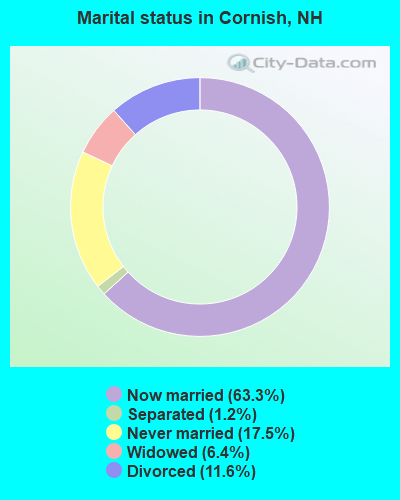
- Never married: 17.5%
- Now married: 63.3%
- Separated: 1.2%
- Widowed: 6.4%
- Divorced: 11.6%
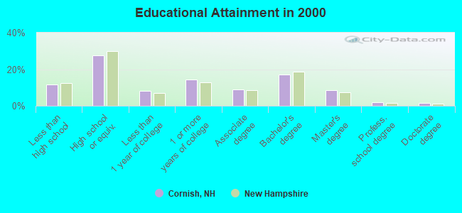
For population 25 years and over in Cornish:
- High school or higher: 88.3%
- Bachelor's degree or higher: 29.0%
- Graduate or professional degree: 11.8%
- Unemployed: 2.6%
- Mean travel time to work (commute): 25.1 minutes
| Here: | 11.1 |
| New Hampshire average: | 10.9 |
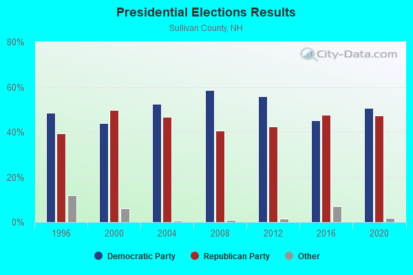
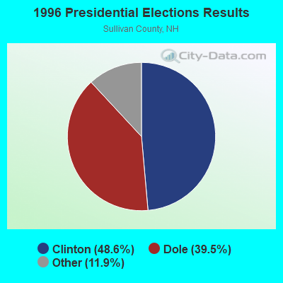
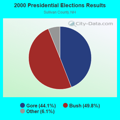
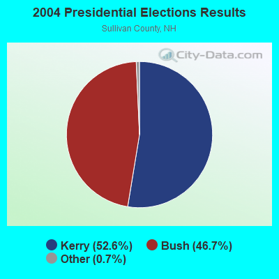
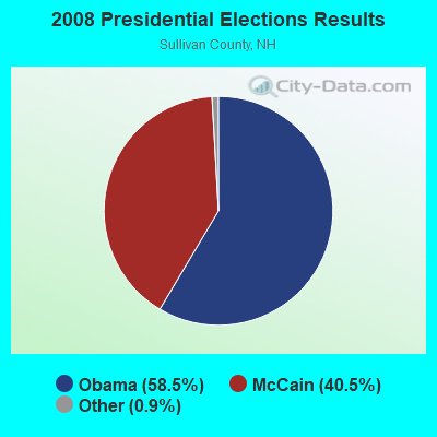
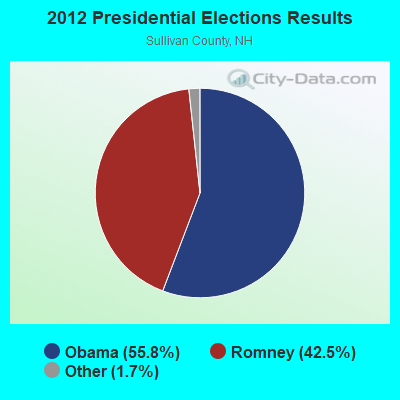
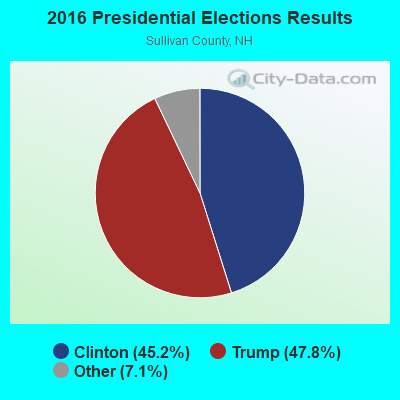
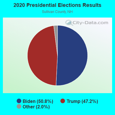
Graphs represent county-level data. Detailed 2008 Election Results
Religion statistics for Cornish, NH (based on Sullivan County data)
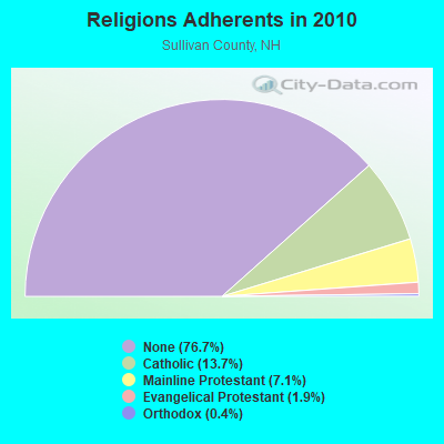
| Religion | Adherents | Congregations |
|---|---|---|
| Catholic | 6,008 | 1 |
| Mainline Protestant | 3,118 | 28 |
| Evangelical Protestant | 849 | 14 |
| Orthodox | 185 | 2 |
| Other | 29 | 2 |
| None | 33,553 | - |
Food Environment Statistics:
| This county: | 1.41 / 10,000 pop. |
| New Hampshire: | 2.14 / 10,000 pop. |
| This county: | 0.23 / 10,000 pop. |
| New Hampshire: | 0.15 / 10,000 pop. |
| Sullivan County: | 1.41 / 10,000 pop. |
| State: | 1.78 / 10,000 pop. |
| This county: | 6.34 / 10,000 pop. |
| State: | 4.02 / 10,000 pop. |
| This county: | 4.93 / 10,000 pop. |
| New Hampshire: | 9.70 / 10,000 pop. |
| This county: | 8.0% |
| New Hampshire: | 7.6% |
| Here: | 26.9% |
| New Hampshire: | 24.4% |
| Sullivan County: | 18.5% |
| State: | 15.9% |
Strongest AM radio stations in Cornish:
- WNTK (1020 AM; 10 kW; NEWPORT, NH; Owner: KOOR COMMUNICATIONS, INC.)
- WTSV (1230 AM; 1 kW; CLAREMONT, NH; Owner: GREAT NORTHERN RADIO, L.L.C.)
- WNBX (1480 AM; 5 kW; SPRINGFIELD, VT)
- WNHV (910 AM; 1 kW; WHITE RIVER JUNCTION, VT)
- WRKO (680 AM; 50 kW; BOSTON, MA; Owner: ENTERCOM BOSTON LICENSE, LLC)
- WNNZ (640 AM; 50 kW; WESTFIELD, MA; Owner: CLEAR CHANNEL BROADCASTING LICENSES, INC.)
- WCRN (830 AM; 50 kW; WORCESTER, MA; Owner: CARTER BROADCASTING CORPORATION)
- WGY (810 AM; 50 kW; SCHENECTADY, NY; Owner: CLEAR CHANNEL BROADCASTING LICENSES, INC.)
- WEEI (850 AM; 50 kW; BOSTON, MA; Owner: ENTERCOM BOSTON LICENSE, LLC)
- WKOX (1200 AM; 50 kW; FRAMINGHAM, MA; Owner: CAPSTAR TX LIMITED PARTNERSHIP)
- WVNE (760 AM; daytime; 25 kW; LEICESTER, MA; Owner: BLOUNT MASSCOM, INC.)
- WBIX (1060 AM; 40 kW; NATICK, MA; Owner: LANGER BROADCASTING CORPORATION)
- WALE (990 AM; 50 kW; GREENVILLE, RI; Owner: NORTH AMERICAN BROADCASTING CO., INC.)
Strongest FM radio stations in Cornish:
- WHDQ (106.1 FM; CLAREMONT, NH; Owner: GREAT NORTHERN RADIO, L.L.C.)
- WVPR (89.5 FM; WINDSOR, VT; Owner: VERMONT PUBLIC RADIO)
- WVRR (101.7 FM; NEWPORT, NH; Owner: CAPSTAR TX LIMITED PARTNERSHIP)
- WJJR (98.1 FM; RUTLAND, VT; Owner: 6 JOHNSON ROAD LICENSES, INC.)
- WZRT (97.1 FM; RUTLAND, VT; Owner: CAPSTAR TX LIMITED PARTNERSHIP)
- WEBK (105.3 FM; KILLINGTON, VT; Owner: 6 JOHNSON ROAD LICENSES, INC.)
- WMXR (93.9 FM; WOODSTOCK, VT; Owner: CLEAR CHANNEL BROADCASTING LICENSES, INC.)
- WEVH (91.3 FM; HANOVER, NH; Owner: NEW HAMPSHIRE PUBLIC RADIO INC)
- WGLV (91.7 FM; WOODSTOCK, VT; Owner: CHRISTIAN MINISTRIES INC)
- WHDQ-FM1 (106.1 FM; RUTLAND, VT; Owner: GREAT NORTHERN RADIO, L.L.C.)
- WXXK (100.5 FM; LEBANON, NH; Owner: CAPSTAR TX LIMITED PARTNERSHIP)
- WNTK-FM (99.7 FM; NEW LONDON, NH; Owner: SHEILA E. VINIKOOR)
- WWOD (104.3 FM; HARTFORD, VT; Owner: FAMILY BROADCASTING, INC.)
- WEQX (102.7 FM; MANCHESTER, VT; Owner: NORTHSHIRE COMMUNICATIONS, INC.)
- WXKK (93.5 FM; SPRINGFIELD, VT; Owner: CLEAR CHANNEL BROADCASTING LICENSES, INC.)
- WJAN (95.1 FM; SUNDERLAND, VT; Owner: 6 JOHNSON ROAD LICENSES, INC.)
- W232AP (94.3 FM; WHITE RIVER JUNCTION, VT; Owner: CLEAR CHANNEL BROADCASTING LICENSES, INC.)
- WPNH-FM (100.1 FM; PLYMOUTH, NH; Owner: NORTHEAST COMMUNICATIONS CORPORATION)
- WPKQ (103.7 FM; NORTH CONWAY, NH; Owner: CITADEL BROADCASTING COMPANY)
- WHOM (94.9 FM; MT. WASHINGTON, NH; Owner: CITADEL BROADCASTING COMPANY)
TV broadcast stations around Cornish:
- WVTA (Channel 41; WINDSOR, VT; Owner: VERMONT ETV, INC.)
- WNNE (Channel 31; HARTFORD, VT; Owner: HEARST-ARGYLE STATIONS, INC.)
- W17CI (Channel 17; CLAREMONT, NH; Owner: UPPER VALLEY BROADCASTING, LLC)
- W15BK (Channel 15; HANOVER, NH; Owner: UNIVERSITY OF NEW HAMPSHIRE)
- W10AC (Channel 10; CLAREMONT, NH; Owner: CLAREMONT TELEVISION, INC.)
- W12AF (Channel 12; CLAREMONT, NH; Owner: CLAREMONT TELEVISION INC.)
- W62AT (Channel 62; BELLOWS FALLS, VT; Owner: MT. MANSFIELD TELEVISION, INC.)
- National Bridge Inventory (NBI) Statistics
- 15Number of bridges
- 105ft / 32.2mTotal length
- $47,130,000Total costs
- 12,309Total average daily traffic
- 682Total average daily truck traffic
- 18,208Total future (year 2042) average daily traffic
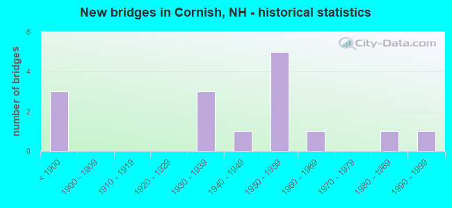
- New bridges - historical statistics
- 3Before 1900
- 31930-1939
- 11940-1949
- 51950-1959
- 11960-1969
- 11980-1989
- 11990-1999
FCC Registered Antenna Towers:
7- Terrance Turner, 200 Burr Rd (Lat: 43.511361 Lon: -72.260972), Type: 51.8, Structure height: 33019 m, Overall height: 51.8 m, Registrant: Tilson Technology, Tturner@tilsontech.Com, 4th Floor, Portl-and, Phone: (207) 956-3440
- Terrance Turner, 200 Burr Rd (Lat: 43.511361 Lon: -72.260972), Type: 51.8, Structure height: 33019 m, Overall height: 51.8 m, Registrant: Tilson Technology, Tturner@tilsontech.Com, 4th Floor, Portl-and, Phone: (207) 956-3440
- Terry Turner, 200 Burr Rd (Lat: 43.511361 Lon: -72.260972), Type: 51.8, Structure height: 33019 m, Overall height: 51.8 m, Registrant: Tilson Technology, Tturner@tilsontech.Com, 4th Floor, Portl-and, Phone: (207) 956-3440
- Terry Turner, 200 Burr Rd (Lat: 43.511361 Lon: -72.260972), Type: 51.8, Structure height: 33019 m, Overall height: 51.8 m, Registrant: Tilson Technology, Tturner@tilsontech.Com, 4th Floor, Portl-and, Phone: (207) 956-3440
- Kelley E Spear, 200 Burr Rd (Lat: 43.511361 Lon: -72.260972), Type: 51.8, Structure height: 33019 m, Overall height: 51.8 m, Registrant: Tilson Technology, Kspear@tilsontech.Com, 4th Floor, 2798204 Portl-and, Phone: (207) 956-3440
- Kelley Spear, 200 Burr Rd (Lat: 43.511361 Lon: -72.260972), Type: 51.8, Structure height: 33019 m, Overall height: 51.8 m, Registrant: Tilson Technology, Kspear@tilsontech.Com, 4th Floor, 2798204 Portl-and, Phone: (207) 956-3440
- Donna Kellison, 200 Burr Rd (Lat: 43.511361 Lon: -72.260972), Type: 51.8, Structure height: 33019 m, Overall height: 51.8 m, Registrant: Vertical Bridge Development, LLC, Fcc-Faa@verticalbridge.Com, Suite 200, Boca -Raton, Phone: (561) 406-4015
FCC Registered Amateur Radio Licenses:
12 (See the full list of FCC Registered Amateur Radio Licenses in Cornish)FAA Registered Aircraft:
1- Aircraft: THARP RICHARD CHALLENGER II (Category: Land, Seats: 2, Weight: Up to 12,499 Pounds), Engine: ROTAX 503 SERIES (52 HP) (Reciprocating)
N-Number: 28RT, N28RT, N-28RT, Serial Number: CH2-0699-1888, Year manufactured: 2001, Airworthiness Date: 11/24/2008, Certificate Issue Date: 06/24/2008
Registrant (Individual): Brian Meyette, 166 Skyline Dr, Cornish, NH 03745
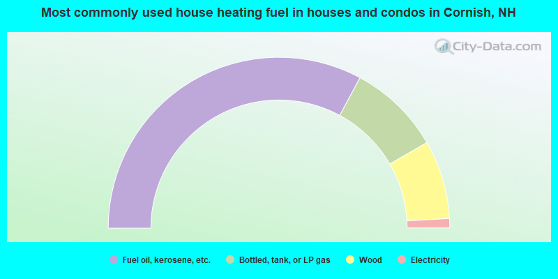
- 65.8%Fuel oil, kerosene, etc.
- 17.6%Bottled, tank, or LP gas
- 14.9%Wood
- 1.8%Electricity
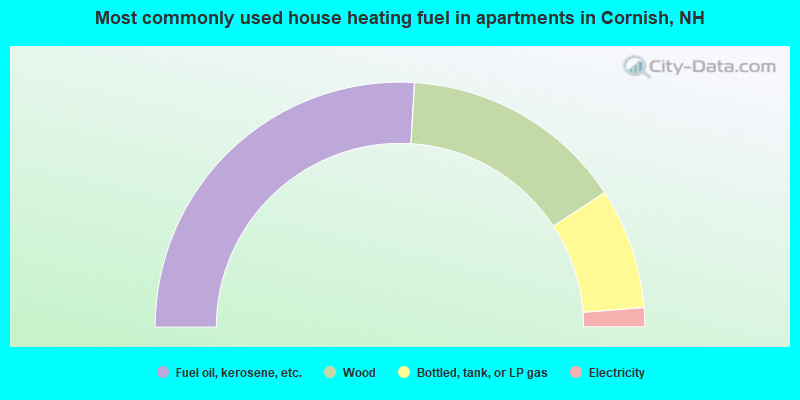
- 51.9%Fuel oil, kerosene, etc.
- 29.6%Wood
- 16.0%Bottled, tank, or LP gas
- 2.5%Electricity
Cornish compared to New Hampshire state average:
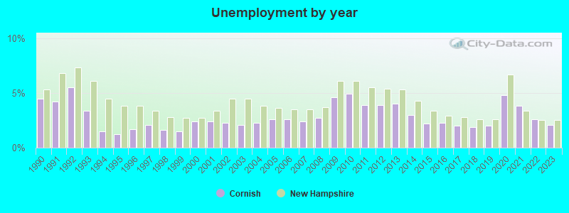
- Unemployed percentage significantly below state average.
- Black race population percentage significantly below state average.
- Hispanic race population percentage significantly below state average.
- Median age above state average.
- Foreign-born population percentage significantly below state average.
- Renting percentage below state average.
- Length of stay since moving in significantly above state average.
- Number of rooms per house significantly below state average.
- House age significantly below state average.
Cornish on our top lists:
- #89 on the list of "Top 101 cities with the most residents born in Other Central America (population 500+)"

|
|
Total of 46 patent applications in 2008-2024.