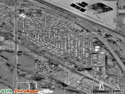
Drexel-Alvernon, Arizona
Submit your own pictures of this place and show them to the world
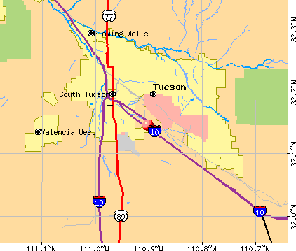
- OSM Map
- General Map
- Google Map
- MSN Map
| Males: 2,419 | |
| Females: 2,504 |
| Median resident age: | 30.0 years |
| Arizona median age: | 34.2 years |
Zip codes: 85706.
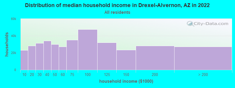
| Drexel-Alvernon: | $53,938 |
| AZ: | $74,568 |
Estimated per capita income in 2022: $21,031 (it was $11,068 in 2000)
Drexel-Alvernon CDP income, earnings, and wages data
Estimated median house or condo value in 2022: $213,805 (it was $69,200 in 2000)
| Drexel-Alvernon: | $213,805 |
| AZ: | $402,800 |
Mean prices in 2022: all housing units: $358,231; detached houses: $392,439; townhouses or other attached units: $275,497; in 2-unit structures: over $1,000,000; in 3-to-4-unit structures: $210,654; in 5-or-more-unit structures: $246,614; mobile homes: $121,731; occupied boats, rvs, vans, etc.: $16,113
Drexel-Alvernon, AZ residents, houses, and apartments details
Detailed information about poverty and poor residents in Drexel-Alvernon, AZ
Compare current foreclosures near your location:
| Photo | Address | Area | Beds / Baths | Price | Details |
|---|---|---|---|---|---|

|
#1
N Rhodes St
Pretty Prairie, KS 67570
|
1,725 sq. feet
|
2 baths 4 beds |
show details | |

|
#2
S Goddard Rd
Goddard, KS 67052
|
1,054 sq. feet
|
2 baths 2 beds |
show details | |

|
#3
W 21st St N
Cheney, KS 67025
|
3,190 sq. feet
|
3 baths 5 beds |
show details | |

|
#4
E Winterset St
Goddard, KS 67052
|
816 sq. feet
|
1 baths 2 beds |
show details | |

|
#5
NE Waterloo Ave
Murdock, KS 67111
|
1,220 sq. feet
|
1 baths 3 beds |
show details | |

|
#6
W 39th St S
Goddard, KS 67052
|
4,221 sq. feet
|
3 baths 3 beds |
show details | |

|
#7
E Arlington Rd
Haven, KS 67543
|
960 sq. feet
|
1 baths 2 beds |
show details | |

|
#8
S 391st St W
Cheney, KS 67025
|
2,558 sq. feet
|
3 baths 3 beds |
show details | |

|
#9
SE Viney Ave
Murdock, KS 67111
|
- sq. feet
|
- baths - beds |
show details | |

|
#10
W Main St
Mount Hope, KS 67108
|
- sq. feet
|
- baths - beds |
show details |
| Photo | Address | Area | Beds / Baths | Price | Details |
|---|---|---|---|---|---|

|
#11
N 189th Cir W
Colwich, KS 67030
|
- sq. feet
|
- baths - beds |
show details | |

|
#12
N Main St
Goddard, KS 67052
|
- sq. feet
|
- baths - beds |
show details | |

|
#13
Martens Ct
Goddard, KS 67052
|
- sq. feet
|
- baths - beds |
show details | |

|
#14
E 4th Ave Apt 1
Cheney, KS 67025
|
- sq. feet
|
- baths - beds |
show details | |

|
#15
W Maple St Lot D
Goddard, KS 67052
|
- sq. feet
|
- baths - beds |
show details | |

|
#16
W 47th St S
Garden Plain, KS 67050
|
- sq. feet
|
- baths - beds |
show details | |

|
#17
S 339th St W
Cheney, KS 67025
|
- sq. feet
|
- baths - beds |
show details | |

|
#18
E Casey Dr
Goddard, KS 67052
|
- sq. feet
|
- baths - beds |
show details | |

|
Check over 1 million property listings on Foreclosure.com!
|
browse all offers | |||

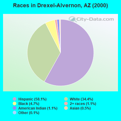
- 2,43458.1%Hispanic
- 1,44034.4%White alone
- 1954.7%Black alone
- 451.1%American Indian alone
- 481.1%Two or more races
- 220.5%Asian alone
- 50.1%Other race alone
- 30.07%Native Hawaiian and Other
Pacific Islander alone
 Recent articles from our blog. Our writers, many of them Ph.D. graduates or candidates, create easy-to-read articles on a wide variety of topics.

 | What streets should I avoid if I want to live in Tucson? (77 replies) |
| No bids on Tempe's Centerpoint Towers (40 replies) |
| Is it crowded in AZ???? (80 replies) |
Ancestries: German (11.3%), Irish (7.0%), English (3.4%), Italian (3.2%), United States (2.1%), Polish (1.9%).
Current Local Time: MST (no DST) time zone
Land area: 0.92 square miles.
Population density: 5,330 people per square mile (average).
683 residents are foreign born (16.0% Latin America).
| This place: | 16.3% |
| Arizona: | 12.8% |
| Drexel-Alvernon CDP: | 1.2% ($835) |
| Arizona: | 0.9% ($962) |
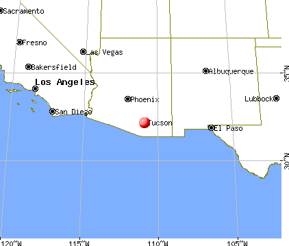
Nearest city with pop. 50,000+: Tucson, AZ  (4.9 miles , pop. 486,699).
Nearest city with pop. 1,000,000+: Phoenix, AZ (117.5 miles , pop. 1,321,045).
Nearest cities:
), ), ), ), Latitude: 32.15 N, Longitude: 110.90 W
Area code commonly used in this area: 520
Property values in Drexel-Alvernon, AZ
| Here: | 3.6% |
| Arizona: | 3.8% |
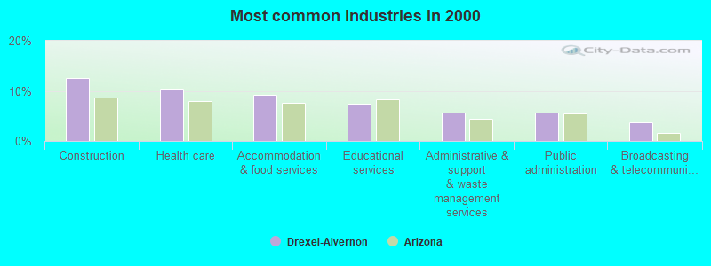
- Construction (12.5%)
- Health care (10.5%)
- Accommodation & food services (9.2%)
- Educational services (7.4%)
- Administrative & support & waste management services (5.6%)
- Public administration (5.6%)
- Broadcasting & telecommunications (3.7%)
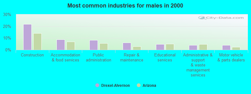
- Construction (21.8%)
- Accommodation & food services (8.6%)
- Public administration (8.2%)
- Repair & maintenance (6.2%)
- Educational services (4.7%)
- Administrative & support & waste management services (4.1%)
- Motor vehicle & parts dealers (3.9%)
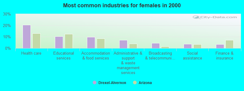
- Health care (20.4%)
- Educational services (10.3%)
- Accommodation & food services (9.7%)
- Administrative & support & waste management services (7.2%)
- Broadcasting & telecommunications (4.6%)
- Social assistance (3.8%)
- Finance & insurance (3.6%)
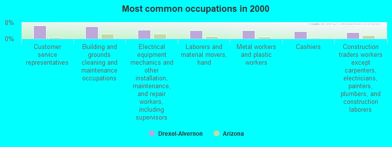
- Customer service representatives (6.5%)
- Building and grounds cleaning and maintenance occupations (6.0%)
- Electrical equipment mechanics and other installation, maintenance, and repair workers, including supervisors (4.4%)
- Laborers and material movers, hand (4.1%)
- Metal workers and plastic workers (4.0%)
- Cashiers (3.6%)
- Construction traders workers except carpenters, electricians, painters, plumbers, and construction laborers (3.3%)
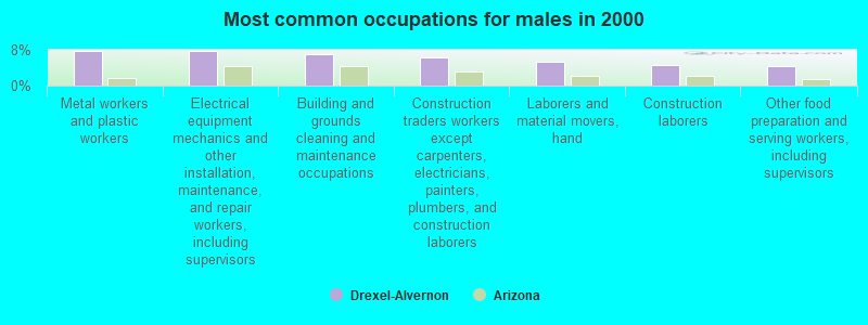
- Metal workers and plastic workers (7.8%)
- Electrical equipment mechanics and other installation, maintenance, and repair workers, including supervisors (7.7%)
- Building and grounds cleaning and maintenance occupations (6.9%)
- Construction traders workers except carpenters, electricians, painters, plumbers, and construction laborers (6.3%)
- Laborers and material movers, hand (5.3%)
- Construction laborers (4.7%)
- Other food preparation and serving workers, including supervisors (4.3%)
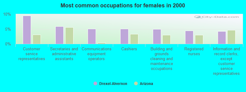
- Customer service representatives (9.5%)
- Secretaries and administrative assistants (5.8%)
- Communications equipment operators (5.0%)
- Cashiers (5.0%)
- Building and grounds cleaning and maintenance occupations (4.9%)
- Registered nurses (4.5%)
- Information and record clerks, except customer service representatives (4.2%)
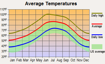
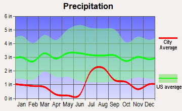
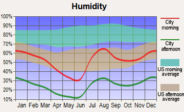
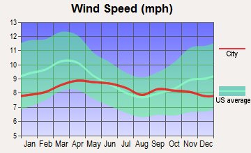
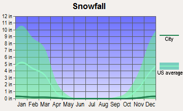
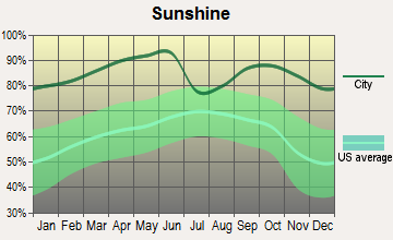
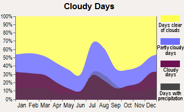
Average climate in Drexel-Alvernon, Arizona
Based on data reported by over 4,000 weather stations
(lower is better)
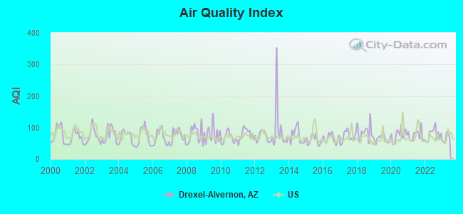
Air Quality Index (AQI) level in 2022 was 77.7. This is about average.
| City: | 77.7 |
| U.S.: | 72.6 |
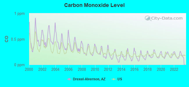
Carbon Monoxide (CO) [ppm] level in 2022 was 0.180. This is better than average. Closest monitor was 4.3 miles away from the city center.
| City: | 0.180 |
| U.S.: | 0.251 |
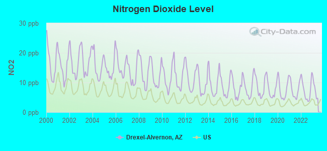
Nitrogen Dioxide (NO2) [ppb] level in 2022 was 7.42. This is significantly worse than average. Closest monitor was 4.3 miles away from the city center.
| City: | 7.42 |
| U.S.: | 5.11 |
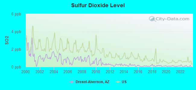
Sulfur Dioxide (SO2) [ppb] level in 2022 was 0.102. This is significantly better than average. Closest monitor was 4.3 miles away from the city center.
| City: | 0.102 |
| U.S.: | 1.515 |

Ozone [ppb] level in 2022 was 33.4. This is about average. Closest monitor was 4.3 miles away from the city center.
| City: | 33.4 |
| U.S.: | 33.3 |
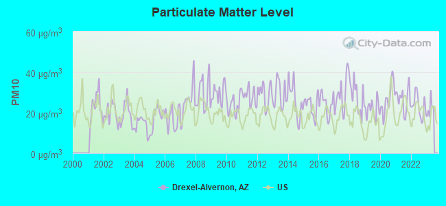
Particulate Matter (PM10) [µg/m3] level in 2022 was 23.4. This is worse than average. Closest monitor was 4.3 miles away from the city center.
| City: | 23.4 |
| U.S.: | 19.2 |
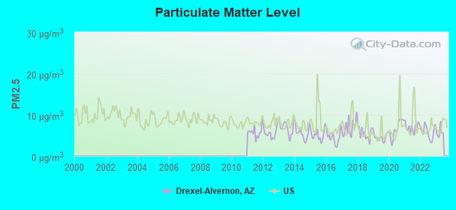
Particulate Matter (PM2.5) [µg/m3] level in 2022 was 5.80. This is better than average. Closest monitor was 11.4 miles away from the city center.
| City: | 5.80 |
| U.S.: | 8.11 |
Earthquake activity:
Drexel-Alvernon-area historical earthquake activity is significantly above Arizona state average. It is 1459% greater than the overall U.S. average.On 6/28/1992 at 11:57:34, a magnitude 7.6 (6.2 MB, 7.6 MS, 7.3 MW, Depth: 0.7 mi, Class: Major, Intensity: VIII - XII) earthquake occurred 355.1 miles away from the city center, causing 3 deaths (1 shaking deaths, 2 other deaths) and 400 injuries, causing $100,000,000 total damage and $40,000,000 insured losses
On 5/19/1940 at 04:36:40, a magnitude 7.2 (7.2 UK) earthquake occurred 288.9 miles away from the city center, causing $33,000,000 total damage
On 12/31/1934 at 18:45:56, a magnitude 7.1 (7.1 UK) earthquake occurred 286.2 miles away from the city center
On 10/16/1999 at 09:46:44, a magnitude 7.4 (6.3 MB, 7.4 MS, 7.2 MW, 7.3 ML) earthquake occurred 359.3 miles away from Drexel-Alvernon center
On 10/15/1979 at 23:16:54, a magnitude 7.0 (5.7 MB, 6.9 MS, 7.0 ML, 6.4 MW) earthquake occurred 280.3 miles away from the city center
On 11/24/1987 at 13:15:56, a magnitude 6.7 (6.0 MB, 6.6 MS, 6.7 ML, 6.1 ML, Class: Strong, Intensity: VII - IX) earthquake occurred 301.2 miles away from Drexel-Alvernon center
Magnitude types: body-wave magnitude (MB), local magnitude (ML), surface-wave magnitude (MS), moment magnitude (MW)
Natural disasters:
The number of natural disasters in Pima County (13) is near the US average (15).Major Disasters (Presidential) Declared: 10
Emergencies Declared: 1
Causes of natural disasters: Floods: 9, Storms: 8, Fires: 2, Hurricane: 1, Tornado: 1, Other: 1 (Note: some incidents may be assigned to more than one category).

Hospitals and medical centers near Drexel-Alvernon:
- AVALON SOUTHWEST HEALTH AND REHABILITATION (Nursing Home, about 3 miles away; TUCSON, AZ)
- TUCSON SOUTH CENTRAL DIALYSIS (DVA) (Dialysis Facility, about 3 miles away; TUCSON, AZ)
- UNIVERSITY OF ARIZONA MEDICAL CTR- SOUTH CAM, THE Acute Care Hospitals (about 3 miles away; TUCSON, AZ)
- DESERT DIALYSIS CENTER SOUTH TUCSON (DCI) (Dialysis Facility, about 4 miles away; TUCSON, AZ)
- ARIZONA STATE VETERAN HOME-TUCSON (Nursing Home, about 5 miles away; TUCSON, AZ)
- DEPENDABLE HOME HEALTH, INC (Home Health Center, about 5 miles away; TUCSON, AZ)
- DEPENDABLE NURSES INC (Home Health Center, about 5 miles away; TUCSON, AZ)
Colleges/universities with over 2000 students nearest to Drexel-Alvernon:
- Pima Community College (about 6 miles; Tucson, AZ; Full-time enrollment: 18,794)
- University of Arizona (about 7 miles; Tucson, AZ; FT enrollment: 36,324)
- Pima Medical Institute-Tucson (about 8 miles; Tucson, AZ; FT enrollment: 2,357)
- Central Arizona College (about 72 miles; Coolidge, AZ; FT enrollment: 4,893)
- Eastern Arizona College (about 83 miles; Thatcher, AZ; FT enrollment: 3,810)
- Cochise College (about 90 miles; Douglas, AZ; FT enrollment: 8,597)
- Arizona State University-Polytechnic (about 93 miles; Mesa, AZ; FT enrollment: 3,311)
Points of interest:
Notable location: Rural / Metro Fire Department Station 73 (A). Display/hide its location on the map
Church in Drexel-Alvernon: Kingdom Hall of Jehovahs Witnesses (A). Display/hide its location on the map
Park in Drexel-Alvernon: Los Niños Neighborhood Park (1). Display/hide its location on the map
| This place: | 3.2 people |
| Arizona: | 2.6 people |
| This place: | 74.4% |
| Whole state: | 68.2% |
| This place: | 9.0% |
| Whole state: | 6.2% |
Likely homosexual households (counted as self-reported same-sex unmarried-partner households)
- Lesbian couples: 0.7% of all households
- Gay men: 0.2% of all households
| This place: | 18.5% |
| Whole state: | 13.9% |
| This place: | 7.3% |
| Whole state: | 6.2% |
For population 15 years and over in Drexel-Alvernon:
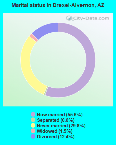
- Never married: 29.8%
- Now married: 55.6%
- Separated: 0.6%
- Widowed: 1.5%
- Divorced: 12.4%
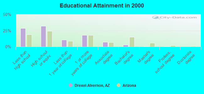
For population 25 years and over in Drexel-Alvernon:
- High school or higher: 71.3%
- Bachelor's degree or higher: 3.9%
- Graduate or professional degree: 1.2%
- Unemployed: 5.5%
- Mean travel time to work (commute): 22.2 minutes
| Here: | 12.7 |
| Arizona average: | 13.1 |
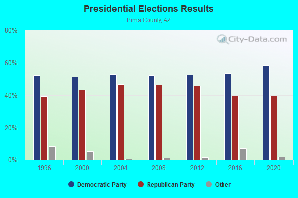
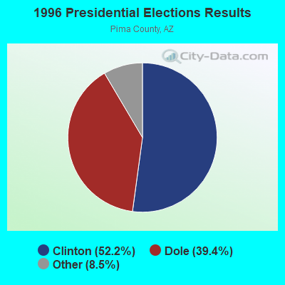
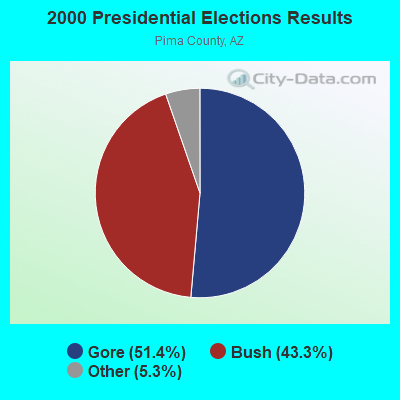
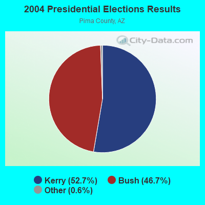
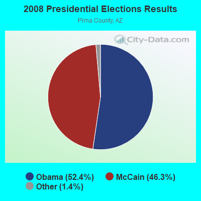

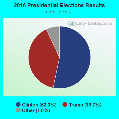
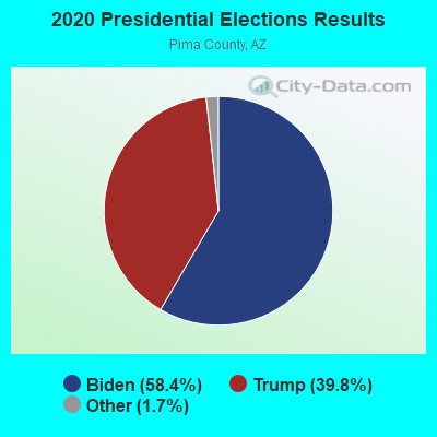
Graphs represent county-level data. Detailed 2008 Election Results
Religion statistics for Drexel-Alvernon, AZ (based on Pima County data)
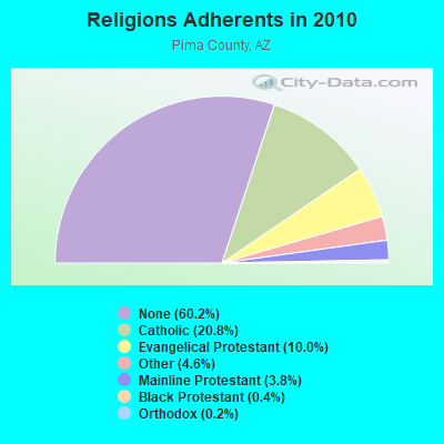
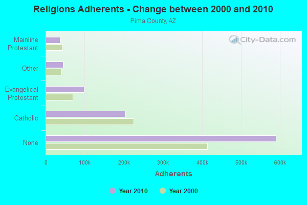
| Religion | Adherents | Congregations |
|---|---|---|
| Catholic | 203,770 | 50 |
| Evangelical Protestant | 98,278 | 362 |
| Other | 45,011 | 128 |
| Mainline Protestant | 37,037 | 77 |
| Black Protestant | 4,190 | 14 |
| Orthodox | 2,260 | 5 |
| None | 589,717 | - |
Food Environment Statistics:
| Here: | 1.22 / 10,000 pop. |
| Arizona: | 1.36 / 10,000 pop. |
| This county: | 0.09 / 10,000 pop. |
| Arizona: | 0.14 / 10,000 pop. |
| This county: | 0.52 / 10,000 pop. |
| Arizona: | 0.55 / 10,000 pop. |
| This county: | 2.27 / 10,000 pop. |
| Arizona: | 2.47 / 10,000 pop. |
| Pima County: | 6.17 / 10,000 pop. |
| State: | 6.21 / 10,000 pop. |
| This county: | 7.8% |
| State: | 8.0% |
| This county: | 21.2% |
| State: | 22.8% |
| Pima County: | 15.2% |
| Arizona: | 14.2% |
5.84% of this county's 2021 resident taxpayers lived in other counties in 2020 ($71,876 average adjusted gross income)
| Here: | 5.84% |
| Arizona average: | 6.85% |
0.07% of residents moved from foreign countries ($644 average AGI)
Pima County: 0.07% Arizona average: 0.03%
Top counties from which taxpayers relocated into this county between 2020 and 2021:
| from Maricopa County, AZ | |
| from Pinal County, AZ | |
| from Cochise County, AZ |
5.17% of this county's 2020 resident taxpayers moved to other counties in 2021 ($65,979 average adjusted gross income)
| Here: | 5.17% |
| Arizona average: | 5.72% |
0.06% of residents moved to foreign countries ($677 average AGI)
Pima County: 0.06% Arizona average: 0.03%
Top counties to which taxpayers relocated from this county between 2020 and 2021:
| to Maricopa County, AZ | |
| to Pinal County, AZ | |
| to Cochise County, AZ |
Strongest AM radio stations in Drexel-Alvernon:
- KQTL (1210 AM; 10 kW; SAHUARITA, AZ; Owner: RADIO UNICA OF TUCSON LICENSE CORP.)
- KFLT (830 AM; 50 kW; TUCSON, AZ; Owner: FAMILY LIFE B/CING SYSTEM, INC.)
- KTKT (990 AM; 10 kW; TUCSON, AZ; Owner: ARIZONA LOTUS CORP.)
- KUAZ (1550 AM; daytime; 50 kW; TUCSON, AZ; Owner: ARIZONA BOARD OF REGENTS)
- KNST (790 AM; 5 kW; TUCSON, AZ)
- KEVT (1030 AM; 10 kW; CORTARO, AZ; Owner: ONE MART CORP.)
- KTZR (1450 AM; 1 kW; TUCSON, AZ; Owner: CLEAR CHANNEL BROADCASTING LICENSES, INC.)
- KJLL (1330 AM; 5 kW; SOUTH TUCSON, AZ; Owner: HUDSON COMMUNICATIONS, INC)
- KXEW (1600 AM; 1 kW; SOUTH TUCSON, AZ; Owner: CAM BROADCASTING COMPANY, INC.)
- KGMS (940 AM; 1 kW; TUCSON, AZ)
- KFFN (1490 AM; 1 kW; TUCSON, AZ; Owner: JOURNAL BROADCAST CORPORATION)
- KSAZ (580 AM; 5 kW; MARANA, AZ; Owner: OWL BROADCASTING & DEVELOPMENT, INC.)
- KCUB (1290 AM; 1 kW; TUCSON, AZ; Owner: CITADEL BROADCASTING COMPANY)
Strongest FM radio stations in Drexel-Alvernon:
- KXCI (91.3 FM; TUCSON, AZ; Owner: FOUNDATION FOR CREATIVE BROADCASTING, INC.)
- KLPX (96.1 FM; TUCSON, AZ; Owner: ARIZONA LOTUS CORPORATION)
- KZLZ-FM2 (105.3 FM; TUCSON, AZ; Owner: ENTRAVISION HOLDINGS, LLC)
- K263AA (100.5 FM; TUCSON, AZ; Owner: EDUCATIONAL MEDIA FOUNDATION)
- K255AC (98.9 FM; TUCSON, AZ; Owner: MARICOPA COUNTY COMMUN. COLLEGE DIST)
- KUAT-FM (90.5 FM; TUCSON, AZ; Owner: ARIZONA BOARD OF REGENTS)
- K292CM (106.3 FM; SUMMERHAVEN, AZ; Owner: ARIZONA LOTUS CORPORATION)
- KZLZ-FM1 (105.3 FM; TUCSON, AZ; Owner: ENTRAVISION HOLDINGS, LLC)
- KIIM-FM (99.5 FM; TUCSON, AZ; Owner: CITADEL BROADCASTING COMPANY)
- KOYT (92.9 FM; TUCSON, AZ; Owner: CAPSTAR TX LIMITED PARTNERSHIP)
- KHYT (107.5 FM; TUCSON, AZ; Owner: CITADEL BROADCASTING COMPANY)
- KRQQ (93.7 FM; TUCSON, AZ; Owner: CAPSTAR TX LIMITED PARTNERSHIP)
- KMXZ-FM (94.9 FM; TUCSON, AZ; Owner: JOURNAL BROADCAST CORPORATION)
- KWFM-FM (97.1 FM; GREEN VALLEY, AZ; Owner: CAPSTAR TX LIMITED PARTNERSHIP)
- KGMG (106.3 FM; ORACLE, AZ; Owner: JOURNAL BROADCAST CORPORATION)
- K261CK (100.1 FM; SAN XAVIER, AZ; Owner: WORLD RADIO NETWORK, INC.)
- KCDX (103.1 FM; FLORENCE, AZ; Owner: DESERT WEST AIR RANCHERS CORPORATION)
- KXKQ (94.1 FM; SAFFORD, AZ; Owner: MCMURRAY COMMUNICATIONS, INC.)
- KZPT (104.1 FM; TUCSON, AZ; Owner: JOURNAL BROADCAST CORPORATION)
- KUAZ-FM (89.1 FM; TUCSON, AZ; Owner: ARIZONA BOARD OF REGENTS)
TV broadcast stations around Drexel-Alvernon:
- KHRR (Channel 40; TUCSON, AZ; Owner: NBC TELEMUNDO PHOENIX, INC.)
- K54FW (Channel 54; TUCSON, AZ; Owner: TRINITY BROADCASTING OF ARIZONA, INC)
- KTTU-TV (Channel 18; TUCSON, AZ; Owner: KTTU-TV, INC.)
- K02BW (Channel 2; CASAS ADOBES, AZ; Owner: EMMIS TELEVISION LICENSE CORPORATION)
- K16EO (Channel 16; ORO VALLEY/TUCSON, AZ; Owner: EMMIS TELEVISION LICENSE CORPORATION)
- KUAS-TV (Channel 27; TUCSON, AZ; Owner: ARIZONA BOARD OF REGENTS FOR BENEFIT OF UNIV OF AZ.)
- National Bridge Inventory (NBI) Statistics
- 4Number of bridges
- 33ft / 9.8mTotal length
- 152,096Total average daily traffic
- 21,764Total average daily truck traffic
FCC Registered Antenna Towers:
4- THOMAS J MCGOVERN, 1 Mile East Of Drexel-Alvernon Along Uprr Row (Lat: 32.146194 Lon: -110.887611), Type: 13.7, Overall height: 13.7 m, Registrant: Union Pacific Railroad, Uplicensing@up.Com, , Omaha, Phone: (402) 544-1777
- THOMAS J MCGOVERN, 1 Mile East Of Drexel-Alvernon Along Uprr Row (Lat: 32.146194 Lon: -110.887611), Type: 13.7, Overall height: 13.7 m, Registrant: Union Pacific Railroad, Uplicensing@up.Com, , Omaha, Phone: (402) 544-1777
- Thomas McGovern, 1 Mile East Of Drexel-Alvernon, Along Uprr Row. (Lat: 32.146194 Lon: -110.887611), Type: 13.7, Structure height: 04019 m, Overall height: 13.7 m, Licensee ID: C, Registrant: Union Pacific Railroad, Uplicensing@up.Com, , Omaha, Phone: (402) 544-1777
- Thomas McGovern, 1 Mile East Of Drexel-Alvernon, Along Uprr Row. (Lat: 32.146194 Lon: -110.887611), Type: 13.7, Structure height: 04019 m, Overall height: 13.7 m, Registrant: Union Pacific Railroad, Uplicensing@up.Com, , Omaha, Phone: (402) 544-1777
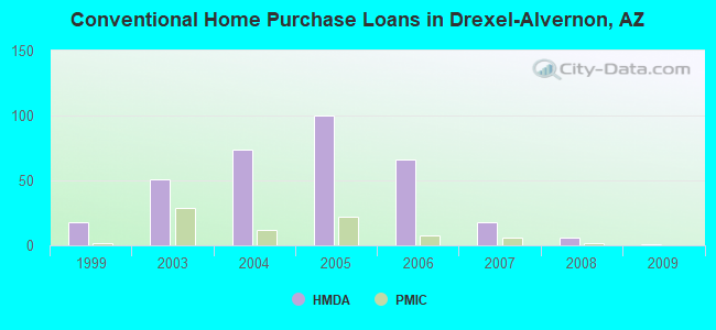
| Home Mortgage Disclosure Act Aggregated Statistics For Year 2009 (Based on 1 full tract) | ||||||||||
| A) FHA, FSA/RHS & VA Home Purchase Loans | B) Conventional Home Purchase Loans | C) Refinancings | D) Home Improvement Loans | F) Non-occupant Loans on < 5 Family Dwellings (A B C & D) | ||||||
|---|---|---|---|---|---|---|---|---|---|---|
| Number | Average Value | Number | Average Value | Number | Average Value | Number | Average Value | Number | Average Value | |
| LOANS ORIGINATED | 12 | $84,587 | 1 | $71,090 | 26 | $106,260 | 2 | $24,190 | 1 | $51,340 |
| APPLICATIONS APPROVED, NOT ACCEPTED | 0 | $0 | 0 | $0 | 1 | $73,070 | 0 | $0 | 0 | $0 |
| APPLICATIONS DENIED | 2 | $86,890 | 0 | $0 | 20 | $110,984 | 1 | $39,500 | 1 | $74,050 |
| APPLICATIONS WITHDRAWN | 0 | $0 | 2 | $61,220 | 9 | $110,589 | 0 | $0 | 0 | $0 |
| FILES CLOSED FOR INCOMPLETENESS | 1 | $78,000 | 0 | $0 | 2 | $135,765 | 0 | $0 | 0 | $0 |
Detailed HMDA statistics for the following Tracts: 0041.12
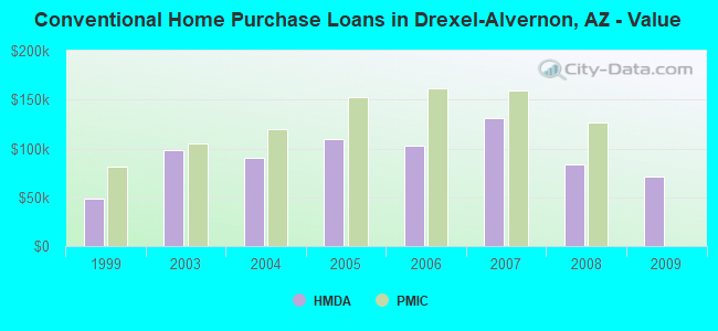
| Private Mortgage Insurance Companies Aggregated Statistics For Year 2009 (Based on 1 full tract) | ||
| B) Refinancings | ||
|---|---|---|
| Number | Average Value | |
| LOANS ORIGINATED | 0 | $0 |
| APPLICATIONS APPROVED, NOT ACCEPTED | 0 | $0 |
| APPLICATIONS DENIED | 1 | $141,200 |
| APPLICATIONS WITHDRAWN | 0 | $0 |
| FILES CLOSED FOR INCOMPLETENESS | 0 | $0 |
Detailed PMIC statistics for the following Tracts: 0041.12
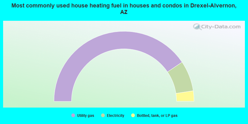
- 81.1%Utility gas
- 14.1%Electricity
- 4.8%Bottled, tank, or LP gas
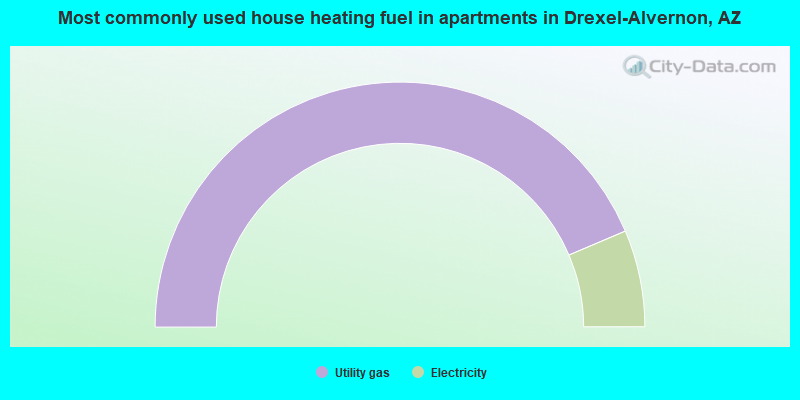
- 87.2%Utility gas
- 12.8%Electricity
Drexel-Alvernon compared to Arizona state average:
- Median house value below state average.
- Unemployed percentage below state average.
- Hispanic race population percentage above state average.
- Renting percentage significantly below state average.
- Length of stay since moving in significantly above state average.
- Number of rooms per house significantly below state average.
- House age significantly below state average.
- Percentage of population with a bachelor's degree or higher significantly below state average.