Lennon, Michigan
Submit your own pictures of this village and show them to the world
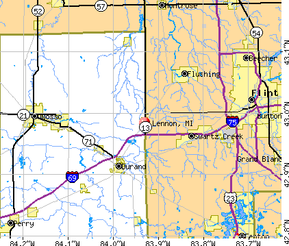
- OSM Map
- General Map
- Google Map
- MSN Map
Population change since 2000: -8.3%
 |
| Males: 253 | |
| Females: 221 |
| Median resident age: | 40.0 years |
| Michigan median age: | 40.3 years |
Zip codes: 48449.
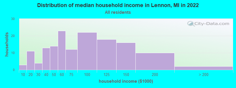
| Lennon: | $60,108 |
| MI: | $66,986 |
Estimated per capita income in 2022: $32,957 (it was $17,148 in 2000)
Lennon village income, earnings, and wages data
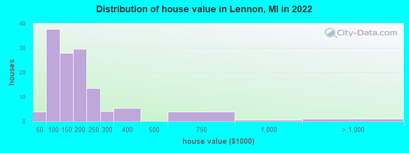
Estimated median house or condo value in 2022: $148,906 (it was $94,100 in 2000)
| Lennon: | $148,906 |
| MI: | $224,400 |
Mean prices in 2022: all housing units: $181,792; detached houses: $188,085; townhouses or other attached units: $189,501; in 2-unit structures: $138,838; in 3-to-4-unit structures: $149,011; in 5-or-more-unit structures: $92,797; mobile homes: $47,804
Median gross rent in 2022: $730.
(8.3% for White Non-Hispanic residents, 50.0% for Black residents, 80.0% for Hispanic or Latino residents, 40.0% for two or more races residents)
Detailed information about poverty and poor residents in Lennon, MI
Compare current foreclosures near Lennon, MI:
| Photo | Address | Area | Beds / Baths | Price | Details |
|---|---|---|---|---|---|

|
#1
S Grand Traverse St
Flint, MI 48507
|
864 sq. feet
|
1 baths 2 beds |
$90,000
|
show details |

|
#2
Plainfield Ave
Flint, MI 48506
|
941 sq. feet
|
1 baths 3 beds |
$95,500
|
show details |

|
#3
Covered Wagons Trl
Flint, MI 48532
|
4,108 sq. feet
|
4 baths 4 beds |
$499,500
|
show details |

|
#4
W Dewey St
Flint, MI 48505
|
1,440 sq. feet
|
1 baths 3 beds |
$120,500
|
show details |

|
#5
Nichols Rd
Lennon, MI 48449
|
- sq. feet
|
- baths - beds |
show details | |

|
#6
Peter B St
Lennon, MI 48449
|
- sq. feet
|
- baths - beds |
show details | |

|
#7
Wilkinson Rd
Lennon, MI 48449
|
- sq. feet
|
- baths - beds |
show details | |

|
#8
Wardwell Dr
Lennon, MI 48449
|
- sq. feet
|
- baths - beds |
show details | |

|
#9
S Sheridan Rd
Lennon, MI 48449
|
- sq. feet
|
- baths - beds |
show details | |

|
#10
N Durand Rd
Lennon, MI 48449
|
- sq. feet
|
- baths - beds |
show details |
| Photo | Address | Area | Beds / Baths | Price | Details |
|---|---|---|---|---|---|

|
#11
E Genesee St
Durand, MI 48429
|
- sq. feet
|
1 baths 3 beds |
$47,500
|
show details |

|
#12
Johnson Rd
Flushing, MI 48433
|
1,986 sq. feet
|
2 baths 4 beds |
show details | |

|
#13
W Wilson Rd
Clio, MI 48420
|
1,916 sq. feet
|
2 baths 4 beds |
show details | |

|
#14
Begole St
Flint, MI 48504
|
894 sq. feet
|
1 baths 2 beds |
show details | |

|
#15
Parkway Ct
Flint, MI 48503
|
1,570 sq. feet
|
1 baths 4 beds |
show details | |

|
#16
Van Vleet Rd
Gaines, MI 48436
|
2,340 sq. feet
|
1 baths 3 beds |
show details | |

|
#17
Moulton Dr
Flint, MI 48507
|
1,276 sq. feet
|
1 baths 3 beds |
show details | |

|
#18
Valley Oaks Cir # 20
Flint, MI 48532
|
1,280 sq. feet
|
3 baths 2 beds |
show details | |

|
#19
Beers Rd
Swartz Creek, MI 48473
|
1,424 sq. feet
|
2 baths 4 beds |
show details | |

|
#20
Dye Krest Dr
Flint, MI 48532
|
1,826 sq. feet
|
2 baths 3 beds |
show details |
| Photo | Address | Area | Beds / Baths | Price | Details |
|---|---|---|---|---|---|

|
#21
N Averill Ave
Flint, MI 48506
|
- sq. feet
|
1 baths 3 beds |
show details | |

|
#22
Mckinley Rd
Montrose, MI 48457
|
1,928 sq. feet
|
2 baths 4 beds |
show details | |

|
#23
Lake Rd
Montrose, MI 48457
|
1,324 sq. feet
|
1 baths 3 beds |
show details | |

|
#24
Howard St
Mount Morris, MI 48458
|
2,766 sq. feet
|
5 baths 5 beds |
show details | |

|
#25
Huggins Ave
Flint, MI 48506
|
1,020 sq. feet
|
1 baths 3 beds |
show details | |

|
#26
Huggins Ave
Flint, MI 48506
|
1,296 sq. feet
|
1 baths 3 beds |
show details | |

|
#27
E Pierson Rd
Flint, MI 48506
|
- sq. feet
|
2 baths 4 beds |
show details | |

|
#28
Litchfield Dr
Flint, MI 48532
|
1,264 sq. feet
|
1 baths 3 beds |
show details | |

|
#29
Spellman Dr
Flint, MI 48503
|
2,035 sq. feet
|
3 baths 4 beds |
show details | |

|
#30
Carpenter Rd
Flushing, MI 48433
|
2,021 sq. feet
|
2 baths 4 beds |
show details |
| Photo | Address | Area | Beds / Baths | Price | Details |
|---|---|---|---|---|---|

|
#31
E Mount Morris Rd
Mount Morris, MI 48458
|
1,986 sq. feet
|
2 baths 4 beds |
show details | |

|
#32
Brownell Blvd
Flint, MI 48504
|
1,263 sq. feet
|
1 baths 3 beds |
show details | |

|
#33
Prospect Dr
Byron, MI 48418
|
1,560 sq. feet
|
2 baths 3 beds |
show details | |

|
#34
Allen Dr
Montrose, MI 48457
|
1,416 sq. feet
|
1 baths 3 beds |
show details | |

|
#35
Partridge Dr
Flushing, MI 48433
|
1,528 sq. feet
|
1 baths 4 beds |
show details | |

|
#36
Herrick St
Flint, MI 48503
|
736 sq. feet
|
1 baths 2 beds |
show details | |

|
#37
S M-52
Owosso, MI 48867
|
1,988 sq. feet
|
2 baths 4 beds |
show details | |

|
#38
Macdonald Ave
Flint, MI 48507
|
941 sq. feet
|
1 baths 3 beds |
show details | |

|
#39
N Jennings Rd
Flint, MI 48504
|
2,018 sq. feet
|
1 baths 4 beds |
show details | |

|
#40
W Pasadena Ave
Flint, MI 48504
|
1,020 sq. feet
|
1 baths 3 beds |
show details |
| Photo | Address | Area | Beds / Baths | Price | Details |
|---|---|---|---|---|---|

|
#41
S Franklin Ave
Flint, MI 48503
|
1,774 sq. feet
|
2 baths 4 beds |
show details | |

|
#42
Woodside Cir
Grand Blanc, MI 48439
|
984 sq. feet
|
1 baths 2 beds |
show details | |

|
#43
Windemere Ave
Flint, MI 48503
|
1,112 sq. feet
|
1 baths 3 beds |
show details | |

|
#44
N Saginaw St
Montrose, MI 48457
|
1,256 sq. feet
|
1 baths 3 beds |
show details | |

|
#45
Stevenson St
Flint, MI 48504
|
942 sq. feet
|
1 baths 3 beds |
show details | |

|
#46
Cook Rd
Swartz Creek, MI 48473
|
1,120 sq. feet
|
1 baths 3 beds |
show details | |

|
#47
N Chevrolet Ave
Flint, MI 48504
|
1 sq. feet
|
1 baths 3 beds |
show details | |

|
#48
Gilbert St
Flint, MI 48532
|
1,056 sq. feet
|
1 baths 2 beds |
show details | |

|
#49
Rolston Rd
Fenton, MI 48430
|
1,240 sq. feet
|
1 baths 3 beds |
show details | |

|
Check over 1 million property listings on Foreclosure.com!
|
browse all offers | |||


- 35593.4%White alone
- 112.9%Two or more races
- 102.6%Hispanic
- 10.3%Black alone
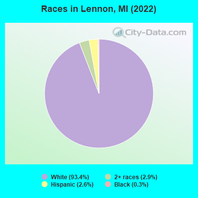
Races in Lennon detailed stats: ancestries, foreign born residents, place of birth
According to our research of Michigan and other state lists, there were 15 registered sex offenders living in Lennon, Michigan as of April 26, 2024.
The ratio of all residents to sex offenders in Lennon is 30 to 1.
Type |
2009 |
2010 |
2011 |
2012 |
2013 |
2014 |
2015 |
2016 |
2017 |
2018 |
2019 |
2020 |
2021 |
2022 |
|---|---|---|---|---|---|---|---|---|---|---|---|---|---|---|
| Murders (per 100,000) | 0 (0.0) | 0 (0.0) | 0 (0.0) | 0 (0.0) | 0 (0.0) | 0 (0.0) | 0 (0.0) | 0 (0.0) | 0 (0.0) | 0 (0.0) | 0 (0.0) | 0 (0.0) | 0 (0.0) | 0 (0.0) |
| Rapes (per 100,000) | 0 (0.0) | 0 (0.0) | 0 (0.0) | 0 (0.0) | 0 (0.0) | 0 (0.0) | 0 (0.0) | 0 (0.0) | 1 (200.8) | 0 (0.0) | 0 (0.0) | 0 (0.0) | 0 (0.0) | 0 (0.0) |
| Robberies (per 100,000) | 0 (0.0) | 0 (0.0) | 0 (0.0) | 0 (0.0) | 0 (0.0) | 0 (0.0) | 0 (0.0) | 0 (0.0) | 0 (0.0) | 0 (0.0) | 0 (0.0) | 0 (0.0) | 0 (0.0) | 0 (0.0) |
| Assaults (per 100,000) | 1 (204.9) | 1 (195.7) | 0 (0.0) | 1 (197.2) | 0 (0.0) | 0 (0.0) | 0 (0.0) | 0 (0.0) | 0 (0.0) | 1 (206.6) | 0 (0.0) | 0 (0.0) | 0 (0.0) | 0 (0.0) |
| Burglaries (per 100,000) | 4 (819.7) | 0 (0.0) | 0 (0.0) | 2 (394.5) | 2 (400.0) | 0 (0.0) | 2 (400.0) | 0 (0.0) | 0 (0.0) | 5 (1,033) | 2 (414.9) | 14 (2,923) | 0 (0.0) | 19 (3,992) |
| Thefts (per 100,000) | 6 (1,230) | 3 (587.1) | 7 (1,370) | 1 (197.2) | 8 (1,600) | 2 (407.3) | 0 (0.0) | 3 (601.2) | 5 (1,004) | 2 (413.2) | 4 (829.9) | 2 (417.5) | 0 (0.0) | 0 (0.0) |
| Auto thefts (per 100,000) | 1 (204.9) | 0 (0.0) | 0 (0.0) | 0 (0.0) | 0 (0.0) | 0 (0.0) | 0 (0.0) | 0 (0.0) | 0 (0.0) | 0 (0.0) | 0 (0.0) | 0 (0.0) | 0 (0.0) | 2 (420.2) |
| Arson (per 100,000) | 0 (0.0) | 0 (0.0) | 0 (0.0) | 0 (0.0) | 0 (0.0) | 0 (0.0) | 0 (0.0) | 1 (200.4) | 0 (0.0) | 0 (0.0) | 0 (0.0) | 1 (208.8) | 0 (0.0) | 0 (0.0) |
| City-Data.com crime index | 163.9 | 62.6 | 54.8 | 75.0 | 92.0 | 16.3 | 28.0 | 24.0 | 200.8 | 130.2 | 62.2 | 221.3 | 0.0 | 313.0 |
The City-Data.com crime index weighs serious crimes and violent crimes more heavily. Higher means more crime, U.S. average is 246.1. It adjusts for the number of visitors and daily workers commuting into cities.
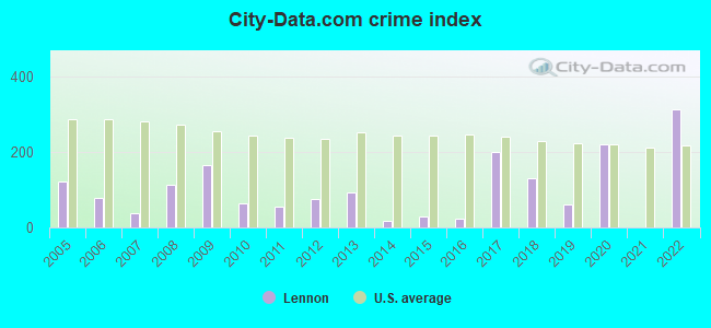
Crime rate in Lennon detailed stats: murders, rapes, robberies, assaults, burglaries, thefts, arson
Full-time law enforcement employees in 2019, including police officers: 1 (1 officers - 1 male; 0 female).
| Officers per 1,000 residents here: | 2.07 |
| Michigan average: | 1.88 |
 Recent articles from our blog. Our writers, many of them Ph.D. graduates or candidates, create easy-to-read articles on a wide variety of topics.

 | What Makes Flint, MI so miserable? (86 replies) |
| Hash Bash (2 replies) |
| Corunna,Lennon?! (3 replies) |
| Where do you reside? (197 replies) |
| How many over age 60 ? (4 replies) |
| Thinking of Moving to Flint? (111 replies) |
Latest news from Lennon, MI collected exclusively by city-data.com from local newspapers, TV, and radio stations
Ancestries: German (26.1%), American (17.2%), English (8.9%), Irish (8.9%), Norwegian (4.5%), Dutch (3.8%).
Current Local Time: EST time zone
Elevation: 795 feet
Land area: 0.92 square miles.
Population density: 514 people per square mile (low).
1 resident is foreign born
| This village: | 0.3% |
| Michigan: | 6.9% |
Median real estate property taxes paid for housing units with mortgages in 2022: $1,861 (1.1%)
Median real estate property taxes paid for housing units with no mortgage in 2022: $1,501 (1.2%)
Nearest city with pop. 50,000+: Flint, MI  (12.4 miles , pop. 124,943).
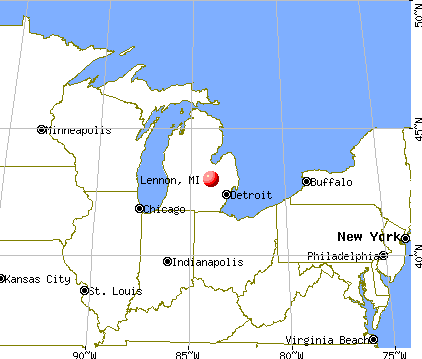
Nearest city with pop. 200,000+: Detroit, MI (59.0 miles , pop. 951,270).
Nearest city with pop. 1,000,000+: Chicago, IL (207.1 miles , pop. 2,896,016).
Nearest cities:
), ), ), ), ), )Latitude: 42.98 N, Longitude: 83.93 W
Area code: 810

| Here: | 4.4% |
| Michigan: | 3.5% |
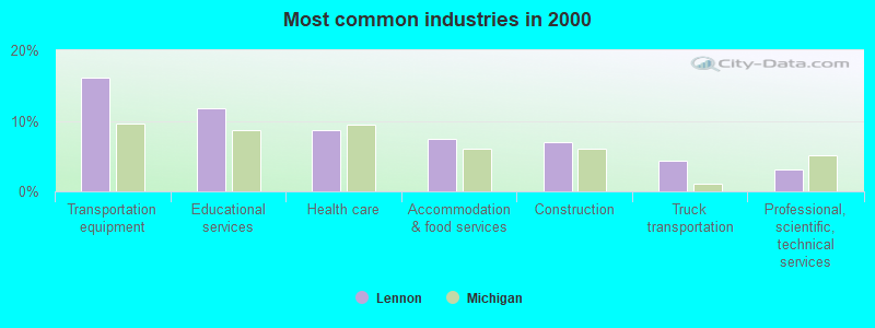
- Transportation equipment (16.2%)
- Educational services (11.8%)
- Health care (8.7%)
- Accommodation & food services (7.4%)
- Construction (7.0%)
- Truck transportation (4.4%)
- Professional, scientific, technical services (3.1%)
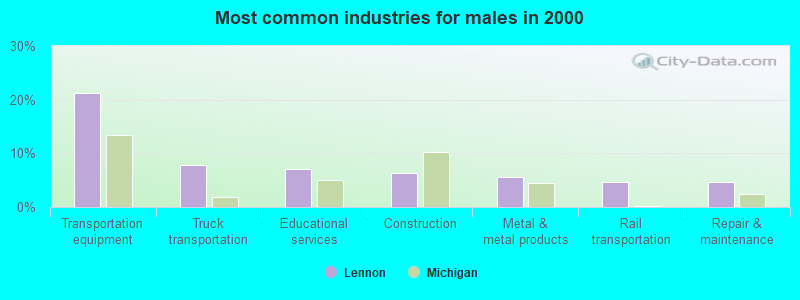
- Transportation equipment (21.3%)
- Truck transportation (7.9%)
- Educational services (7.1%)
- Construction (6.3%)
- Metal & metal products (5.5%)
- Rail transportation (4.7%)
- Repair & maintenance (4.7%)
- Educational services (17.6%)
- Health care (16.7%)
- Accommodation & food services (13.7%)
- Transportation equipment (9.8%)
- Construction (7.8%)
- Public administration (3.9%)
- Administrative & support & waste management services (3.9%)
- Metal workers and plastic workers (7.9%)
- Electrical equipment mechanics and other installation, maintenance, and repair workers, including supervisors (7.4%)
- Building and grounds cleaning and maintenance occupations (6.1%)
- Driver/sales workers and truck drivers (5.2%)
- Vehicle and mobile equipment mechanics, installers, and repairers (4.4%)
- Cooks and food preparation workers (3.9%)
- Preschool, kindergarten, elementary, and middle school teachers (3.5%)
- Metal workers and plastic workers (14.2%)
- Electrical equipment mechanics and other installation, maintenance, and repair workers, including supervisors (13.4%)
- Driver/sales workers and truck drivers (9.4%)
- Building and grounds cleaning and maintenance occupations (6.3%)
- Vehicle and mobile equipment mechanics, installers, and repairers (5.5%)
- Other construction workers and helpers (4.7%)
- Other production occupations, including supervisors (4.7%)
- Financial clerks, except bookkeeping, accounting and auditing clerks (6.9%)
- Cooks and food preparation workers (6.9%)
- Material recording, scheduling, dispatching, and distributing workers (5.9%)
- Building and grounds cleaning and maintenance occupations (5.9%)
- Preschool, kindergarten, elementary, and middle school teachers (4.9%)
- Other office and administrative support workers, including supervisors (4.9%)
- Bus drivers (4.9%)
Average climate in Lennon, Michigan
Based on data reported by over 4,000 weather stations


(lower is better)
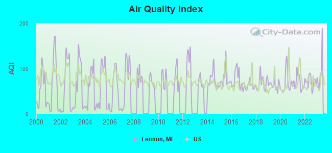
Air Quality Index (AQI) level in 2022 was 70.9. This is about average.
| City: | 70.9 |
| U.S.: | 72.6 |
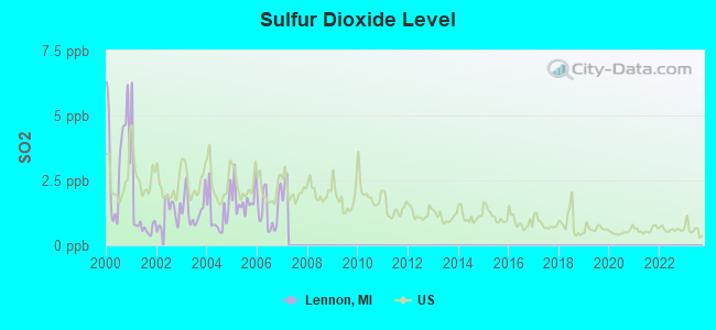
Sulfur Dioxide (SO2) [ppb] level in 2006 was 1.34. This is about average. Closest monitor was 11.5 miles away from the city center.
| City: | 1.34 |
| U.S.: | 1.51 |
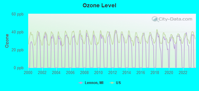
Ozone [ppb] level in 2022 was 31.7. This is about average. Closest monitor was 12.7 miles away from the city center.
| City: | 31.7 |
| U.S.: | 33.3 |
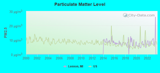
Particulate Matter (PM2.5) [µg/m3] level in 2022 was 8.25. This is about average. Closest monitor was 13.9 miles away from the city center.
| City: | 8.25 |
| U.S.: | 8.11 |
Tornado activity:
Lennon-area historical tornado activity is above Michigan state average. It is 58% greater than the overall U.S. average.
On 6/8/1953, a category F5 (max. wind speeds 261-318 mph) tornado 9.0 miles away from the Lennon village center killed 116 people and injured 844 people and caused between $5,000,000 and $50,000,000 in damages.
On 5/12/1956, a category F4 (max. wind speeds 207-260 mph) tornado 12.7 miles away from the village center killed 3 people and injured 116 people and caused between $500,000 and $5,000,000 in damages.
Earthquake activity:
Lennon-area historical earthquake activity is significantly above Michigan state average. It is 47% smaller than the overall U.S. average.On 9/25/1998 at 19:52:52, a magnitude 5.2 (4.8 MB, 4.3 MS, 5.2 LG, 4.5 MW, Depth: 3.1 mi, Class: Moderate, Intensity: VI - VII) earthquake occurred 208.4 miles away from the city center
On 1/31/1986 at 16:46:43, a magnitude 5.0 (5.0 MB) earthquake occurred 171.0 miles away from the city center
On 5/2/2015 at 16:23:07, a magnitude 4.2 (4.2 MW, Depth: 2.8 mi, Class: Light, Intensity: IV - V) earthquake occurred 92.1 miles away from the city center
On 7/12/1986 at 08:19:37, a magnitude 4.5 (4.5 MB) earthquake occurred 170.8 miles away from Lennon center
On 7/27/1980 at 18:52:21, a magnitude 5.2 (5.1 MB, 4.7 MS, 5.0 UK, 5.2 UK) earthquake occurred 330.5 miles away from Lennon center
On 4/18/2008 at 09:36:59, a magnitude 5.4 (5.1 MB, 4.8 MS, 5.4 MW, 5.2 MW) earthquake occurred 375.7 miles away from Lennon center
Magnitude types: regional Lg-wave magnitude (LG), body-wave magnitude (MB), surface-wave magnitude (MS), moment magnitude (MW)
Natural disasters:
The number of natural disasters in Genesee County (13) is near the US average (15).Major Disasters (Presidential) Declared: 7
Emergencies Declared: 5
Causes of natural disasters: Storms: 7, Floods: 6, Tornadoes: 3, Winds: 2, Blizzard: 1, Hurricane: 1, Power Outage: 1, Snowstorm: 1, Winter Storm: 1, Other: 2 (Note: some incidents may be assigned to more than one category).

Hospitals and medical centers near Lennon:
- DURAND SENIOR CARE AND REHAB CENTER, L L C (Nursing Home, about 6 miles away; DURAND, MI)
- SURGERY CENTER OF GENESEE COUNTY (Hospital, about 8 miles away; FLINT, MI)
- HEARTLAND HEALTH CARE CENTER-FOSTRIAN (Nursing Home, about 9 miles away; FLUSHING, MI)
- GENTIVA HEALTH SERVICES (Home Health Center, about 9 miles away; FLINT, MI)
- FMC DIALYSIS - FLINT (Dialysis Facility, about 9 miles away; FLINT, MI)
- ALL AMERICANS HOME HEALTH CARE (Home Health Center, about 9 miles away; FLINT, MI)
- HOME ADVANTAGE (Home Health Center, about 9 miles away; FLINT, MI)
Amtrak stations near Lennon:
- 6 miles: DURAND (200 RAILROAD ST.) . Services: enclosed waiting area, public restrooms, public payphones, free short-term parking, free long-term parking, taxi stand.
- 15 miles: FLINT (1407 S. DORT HWY.) . Services: ticket office, partially wheelchair accessible, enclosed waiting area, public restrooms, public payphones, vending machines, free short-term parking, free long-term parking, call for car rental service, call for taxi service, public transit connection.
Colleges/universities with over 2000 students nearest to Lennon:
- Kettering University (about 12 miles; Flint, MI; Full-time enrollment: 2,044)
- Baker College of Flint (about 12 miles; Flint, MI; FT enrollment: 3,877)
- Baker College Center for Graduate Studies (about 12 miles; Flint, MI; FT enrollment: 3,405)
- Baker College of Owosso (about 13 miles; Owosso, MI; FT enrollment: 2,081)
- University of Michigan-Flint (about 13 miles; Flint, MI; FT enrollment: 6,284)
- Mott Community College (about 14 miles; Flint, MI; FT enrollment: 7,394)
- Michigan State University (about 33 miles; East Lansing, MI; FT enrollment: 41,736)
User-submitted facts and corrections:
- Hi Guys - I know this may not be relevant to the fact that your town is called Lennon but my name is Frank Lennon and I'm Irish living in Ireland. The name Lennon is an Irish name (John Lennon's grandfather came from Dublin, Ireland's capital city and Paul Mc Cartney's mother was Irish as is his name. The name long ago in the Irish language meant "cloak" and probably referred to the type of cloak that the Lennon clan wore.There are many well known Lennon's around these islands and we are still involved in music, sport etc. (...). Love to all the citizens of Lennon. Frank Lennon
Points of interest:
Notable locations in Lennon: Lennon Station (A), Perkins Library (B), Lennon Village Hall (C). Display/hide their locations on the map
Church in Lennon: Lennon United Methodist Church (A). Display/hide its location on the map
Drinking water stations with addresses in Lennon and their reported violations in the past:
SPEEDWAY (Population served: 300, Groundwater):Past health violations:LENNON CAFE (Population served: 100, Groundwater):
- MCL, Monthly (TCR) - In JUN-2013, Contaminant: Coliform. Follow-up actions: St Compliance achieved (JUN-07-2013), St Violation/Reminder Notice (JUN-12-2013)
Past monitoring violations:VENICE TWP. FIREHALL & COMPLEX (Population served: 25, Groundwater):
- One regular monitoring violation
Past monitoring violations:
- One routine major monitoring violation
- One regular monitoring violation
Drinking water stations with addresses in Lennon that have no violations reported:
- VENICE PK RDF-OFFICE (Population served: 50, Primary Water Source Type: Groundwater)
- LENNON WESLEYAN (Population served: 25, Primary Water Source Type: Groundwater)
| This village: | 2.8 people |
| Michigan: | 2.5 people |
| This village: | 73.5% |
| Whole state: | 66.0% |
| This village: | 8.8% |
| Whole state: | 6.4% |
Likely homosexual households (counted as self-reported same-sex unmarried-partner households)
- Lesbian couples: 1.1% of all households
- Gay men: 0.0% of all households
3 people in other noninstitutional group quarters in 2000
For population 15 years and over in Lennon:
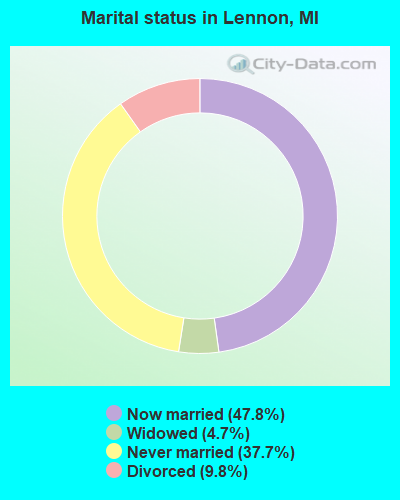
- Never married: 37.7%
- Now married: 47.8%
- Separated: 0.0%
- Widowed: 4.7%
- Divorced: 9.8%
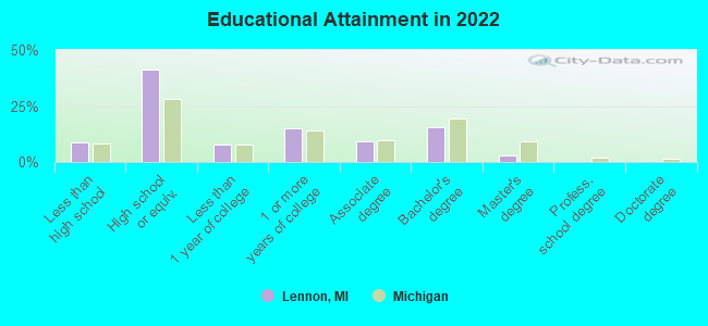
For population 25 years and over in Lennon:
- High school or higher: 91.1%
- Bachelor's degree or higher: 17.4%
- Graduate or professional degree: 3.7%
- Unemployed: 10.2%
- Mean travel time to work (commute): 36.8 minutes
| Here: | 7.9 |
| Michigan average: | 11.0 |
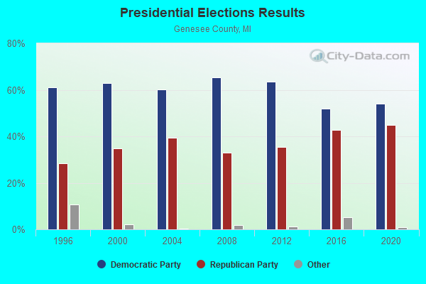
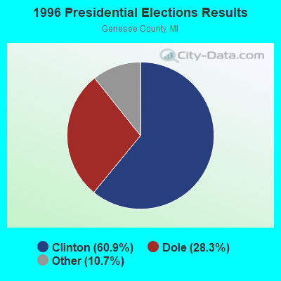
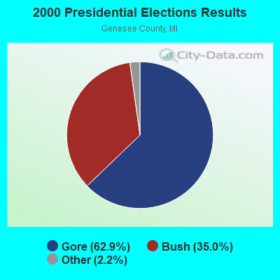
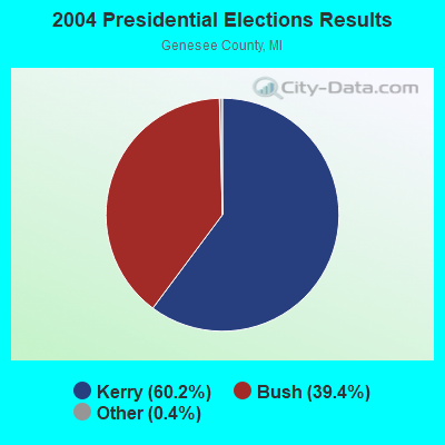
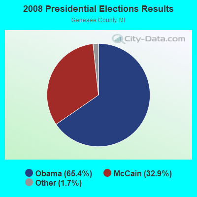

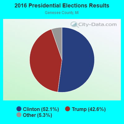
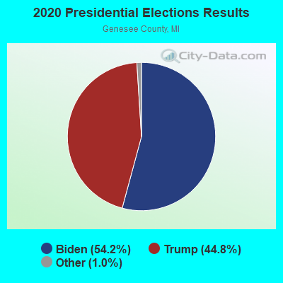
Graphs represent county-level data. Detailed 2008 Election Results
Religion statistics for Lennon, MI (based on Genesee County data)

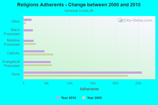
| Religion | Adherents | Congregations |
|---|---|---|
| Evangelical Protestant | 59,625 | 248 |
| Catholic | 45,566 | 25 |
| Mainline Protestant | 22,575 | 82 |
| Black Protestant | 20,768 | 60 |
| Other | 17,837 | 37 |
| Orthodox | 1,392 | 4 |
| None | 258,027 | - |
Food Environment Statistics:
| Genesee County: | 2.51 / 10,000 pop. |
| State: | 2.34 / 10,000 pop. |
| Here: | 0.12 / 10,000 pop. |
| Michigan: | 0.18 / 10,000 pop. |
| Genesee County: | 1.98 / 10,000 pop. |
| State: | 1.52 / 10,000 pop. |
| Genesee County: | 3.04 / 10,000 pop. |
| Michigan: | 2.99 / 10,000 pop. |
| Here: | 5.67 / 10,000 pop. |
| Michigan: | 6.80 / 10,000 pop. |
| Here: | 11.3% |
| Michigan: | 9.7% |
| This county: | 33.6% |
| State: | 29.7% |
| This county: | 12.5% |
| State: | 13.4% |
Health and Nutrition:
| This city: | 48.0% |
| Michigan: | 50.3% |
| This city: | 43.7% |
| Michigan: | 47.9% |
| Lennon: | 30.3 |
| Michigan: | 28.7 |
| This city: | 24.2% |
| State: | 20.6% |
| This city: | 18.3% |
| Michigan: | 10.4% |
| This city: | 6.7 |
| State: | 6.8 |
| Here: | 43.3% |
| State: | 34.1% |
| Lennon: | 52.4% |
| State: | 57.0% |
| This city: | 77.6% |
| Michigan: | 79.6% |
More about Health and Nutrition of Lennon, MI Residents
Lennon government finances - Expenditure in 2017 (per resident):
- Current Operations - Sewerage: $89,000 ($187.76)
Police Protection: $76,000 ($160.34)
Central Staff Services: $47,000 ($99.16)
Regular Highways: $45,000 ($94.94)
General Public Buildings: $17,000 ($35.86)
Financial Administration: $6,000 ($12.66)
General - Other: $2,000 ($4.22)
Protective Inspection and Regulation - Other: $2,000 ($4.22)
- Other Capital Outlay - General - Other: $14,000 ($29.54)
Police Protection: $4,000 ($8.44)
- Total Salaries and Wages: $74,000 ($156.12)
Lennon government finances - Revenue in 2017 (per resident):
- Charges - Sewerage: $101,000 ($213.08)
- Miscellaneous - General Revenue - Other: $5,000 ($10.55)
Sale of Property: $4,000 ($8.44)
Fines and Forfeits: $3,000 ($6.33)
Donations From Private Sources: $2,000 ($4.22)
- State Intergovernmental - Highways: $49,000 ($103.38)
General Local Government Support: $46,000 ($97.05)
Other: $5,000 ($10.55)
- Tax - Property: $103,000 ($217.30)
Other License: $32,000 ($67.51)
Lennon government finances - Debt in 2017 (per resident):
- Long Term Debt - Retired Unspecified Public Purpose: $5,000 ($10.55)
Beginning Outstanding - Unspecified Public Purpose: $5,000 ($10.55)
Lennon government finances - Cash and Securities in 2017 (per resident):
- Other Funds - Cash and Securities: $149,000 ($314.35)
Strongest AM radio stations in Lennon:
- WOAP (1080 AM; 50 kW; OWOSSO, MI)
- WTRX (1330 AM; 5 kW; FLINT, MI; Owner: CITADEL BROADCASTING COMPANY)
- WWJ (950 AM; 50 kW; DETROIT, MI; Owner: INFINITY BROADCASTING OPERATIONS, INC.)
- WXYT (1270 AM; 50 kW; DETROIT, MI; Owner: INFINITY BROADCASTING CORP. OF DETROIT)
- WFNT (1470 AM; 5 kW; FLINT, MI)
- WJR (760 AM; 50 kW; DETROIT, MI; Owner: ABC, INC.)
- WFDF (910 AM; 50 kW; FLINT, MI; Owner: ABC, INC.)
- WCHB (1200 AM; 50 kW; TAYLOR, MI; Owner: RADIO ONE OF DETROIT, LLC)
- WKAR (870 AM; daytime; 10 kW; EAST LANSING, MI; Owner: MICHIGAN STATE UNIVERSITY)
- WDFN (1130 AM; 50 kW; DETROIT, MI; Owner: AMFM RADIO LICENSES, L.L.C.)
- WSNL (600 AM; 1 kW; FLINT, MI)
- WSGW (790 AM; 5 kW; SAGINAW, MI; Owner: NM LICENSING LLC)
- WCXI (1160 AM; 1 kW; FENTON, MI; Owner: BIRACH BROADCASTING CORPORATION)
Strongest FM radio stations in Lennon:
- WFBE (95.1 FM; FLINT, MI; Owner: CITADEL BROADCASTING COMPANY)
- WRSR (103.9 FM; OWOSSO, MI; Owner: CUMULUS LICENSING CORP.)
- WHNN (96.1 FM; BAY CITY, MI; Owner: CITADEL BROADCASTING COMPANY)
- WWCK-FM (105.5 FM; FLINT, MI; Owner: CUMULUS LICENSING CORP.)
- WAKL (88.9 FM; FLINT, MI; Owner: EDUCATIONAL MEDIA FOUNDATION)
- WKAR-FM (90.5 FM; EAST LANSING, MI; Owner: MICHIGAN STATE UNIVERSITY)
- WDZZ-FM (92.7 FM; FLINT, MI; Owner: CUMULUS LICENSING CORP.)
- WIOG (102.5 FM; BAY CITY, MI; Owner: CITADEL BROADCASTING COMPANY)
- WCRZ (107.9 FM; FLINT, MI; Owner: REGENT BROADCASTING OF FLINT, INC.)
- WFUM-FM (91.1 FM; FLINT, MI; Owner: THE REGENTS OF THE UNIV. OF MICHIGAN)
- WLGH (88.1 FM; LEROY TOWNSHIP, MI; Owner: SUPERIOR COMMUNICATIONS)
- WFMK (99.1 FM; EAST LANSING, MI; Owner: CITADEL BROADCASTING COMPANY)
- WHMI-FM (93.5 FM; HOWELL, MI; Owner: THE LIVINGSTON RADIO COMPANY)
- WWBN (101.5 FM; TUSCOLA, MI; Owner: REGENT BROADCASTING OF FLINT, INC.)
- WKCQ (98.1 FM; SAGINAW, MI; Owner: THE MACDONALD BROADCASTING COMPANY)
- WTAC (89.7 FM; BURTON, MI; Owner: SUPERIOR COMMUNICATIONS)
- WILZ (104.5 FM; SAGINAW, MI; Owner: CITADEL BROADCASTING COMPANY)
- WTLZ (107.1 FM; SAGINAW, MI; Owner: NM LICENSING LLC)
TV broadcast stations around Lennon:
- WEYI-TV (Channel 25; SAGINAW, MI; Owner: WEYI BROADCASTING, LLC)
- WSMH (Channel 66; FLINT, MI; Owner: WSMH LICENSEE, LLC)
- WAQP (Channel 49; SAGINAW, MI; Owner: TCT OF MICHIGAN, INC.)
- WJRT-TV (Channel 12; FLINT, MI; Owner: FLINT LICENSE SUBSIDIARY CORP.)
- W09CK (Channel 9; FLINT, MI; Owner: P & P CABLE HOLDINGS, L.L.C.)
- WFUM (Channel 28; FLINT, MI; Owner: UNIVERSITY OF MICHIGAN)
- WNEM-TV (Channel 5; BAY CITY, MI; Owner: MEREDITH CORPORATION)
- WLNS-TV (Channel 6; LANSING, MI; Owner: YOUNG BROADCASTING OF LANSING, INC.)
- WKAR-TV (Channel 23; EAST LANSING, MI; Owner: BOARD OF TRUSTEES, MICH. STATE UNIV.)
- W52CU (Channel 52; PINCONNING, MI; Owner: NTN/SAGINAW, INC.)
- WXON-LP (Channel 54; FLINT, MI; Owner: P & P CABLE HOLDINGS, L.L.C.)
- WPXD (Channel 31; ANN ARBOR, MI; Owner: PAXSON COMMUNICATIONS LICENSE COMPANY, LLC)
- W69BJ (Channel 69; LANSING, MI; Owner: TRI-STATE CHRISTIAN TV, INC.)
- W22CC (Channel 22; PINCONNING, MI; Owner: P & P CABLE HOLDINGS, L.L.C.)
- W69DW (Channel 69; PINCONNING, MI; Owner: NTN/SAGINAW, INC.)
Lennon fatal accident list:
- National Bridge Inventory (NBI) Statistics
- 19Number of bridges
- 141ft / 43.4mTotal length
- $136,000Total costs
- 136,733Total average daily traffic
- 18,486Total average daily truck traffic
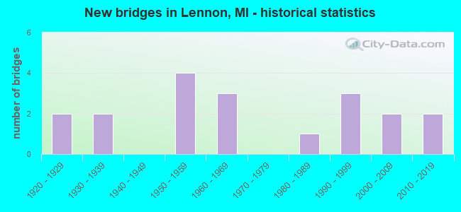
- New bridges - historical statistics
- 21920-1929
- 21930-1939
- 41950-1959
- 31960-1969
- 11980-1989
- 31990-1999
- 22000-2009
- 22010-2019
FCC Registered Antenna Towers:
31 (See the full list of FCC Registered Antenna Towers in Lennon)FCC Registered Microwave Towers:
4- Lennon, Lat: 42.983778 Lon: -83.931361, Type: Silo, Structure height: 50 m, Overall height: 53 m, Call Sign: WQJA249,
Assigned Frequencies: 3650.00 MHz, Grant Date: 07/02/2008, Expiration Date: 07/02/2018, Cancellation Date: 09/01/2018, Certifier: Steve W Osterwyk, Registrant: Invisalink Wireless Enterprises LLC, 9473 Vanvleet Rd., Gaines, MI 48436, Phone: (810) 659-5000, Email:
- Lennon, Lat: 42.983778 Lon: -83.931361, Type: Silo, Structure height: 50 m, Overall height: 53 m, Call Sign: WQJA249,
Assigned Frequencies: 3650.00 MHz, Grant Date: 07/02/2008, Expiration Date: 07/02/2018, Cancellation Date: 09/01/2018, Certifier: Steve W Osterwyk, Registrant: Invisalink Wireless Enterprises LLC, 9473 Vanvleet Rd., Gaines, MI 48436, Phone: (810) 659-5000, Email:
- I69 & BYRON, Byron Road (Lat: 42.963500 Lon: -83.953639), Type: Mtower, Structure height: 57.9 m, Overall height: 60 m, Call Sign: WQYV463,
Assigned Frequencies: 10855.0 MHz, Grant Date: 02/02/2017, Expiration Date: 02/02/2027, Cancellation Date: 01/24/2023, Certifier: Gregory M Romano, Registrant: Verizon, 1300 I St Nw - Suite 500 East, Washington, DC 20005, Phone: (202) 515-2453, Email:
- LENNON GRAIN, Lytle Rd (Lat: 42.983833 Lon: -83.931611), Type: Silo, Structure height: 54 m, Overall height: 55 m, Call Sign: WRAQ865,
Assigned Frequencies: 11485.0 MHz, 11485.0 MHz, 11485.0 MHz, 11485.0 MHz, 11405.0 MHz, 11405.0 MHz, 11405.0 MHz, 11405.0 MHz, 11405.0 MHz, 11405.0 MHz... (+10 more), Grant Date: 02/01/2018, Expiration Date: 02/01/2028, Certifier: Jeff Tebo, Registrant: Intelpath, Hinsdale, IL 60522, Phone: (312) 841-9188, Email:
FCC Registered Amateur Radio Licenses:
24 (See the full list of FCC Registered Amateur Radio Licenses in Lennon)FAA Registered Aircraft:
3- Aircraft: CESSNA 170B (Category: Land, Seats: 4, Weight: Up to 12,499 Pounds, Speed: 105 mph), Engine: CONT MOTOR C145 SERIES (145 HP) (Reciprocating)
N-Number: 1854C, N1854C, N-1854C, Serial Number: 25998, Year manufactured: 1953, Airworthiness Date: 09/12/1955, Certificate Issue Date: 05/27/2004
Registrant (Individual): Russell E Shoebridge, Po Box 204, Lennon, MI 48449 - Aircraft: RUSHKA SHAWN A CHALLENGER II (Category: Land, Seats: 2, Weight: Up to 12,499 Pounds), Engine: BOMBARDIER ROTAX (ALL) (Reciprocating)
N-Number: 2535Z, N2535Z, N-2535Z, Serial Number: CH210981790, Year manufactured: 1998, Airworthiness Date: 09/26/2001, Certificate Issue Date: 01/19/2001
Registrant (Individual): Shawn A Rushka, 11675 Copas Rd, Lennon, MI 48449 - Aircraft: DJI PHANTOM 2 (Category: Land, Engines: 4), Engine: Electric
N-Number: 697YD, N697YD, N-697YD, Serial Number: PH645492659, Certificate Issue Date: 04/18/2016
Registrant (Corporation): Steiner Tractor Parts Inc, 1660 S M 13, Lennon, MI 48449
Deregistered: Cancel Date: 09/06/2019
2002 - 2018 National Fire Incident Reporting System (NFIRS) incidents
- Fire incident types reported to NFIRS in Lennon, MI
- 15353.1%Structure Fires
- 7526.0%Outside Fires
- 4816.7%Mobile Property/Vehicle Fires
- 124.2%Other
 Based on the data from the years 2002 - 2018 the average number of fires per year is 17. The highest number of reported fires - 45 took place in 2003, and the least - 5 in 2012. The data has a rising trend.
 When looking into fire subcategories, the most reports belonged to: Structure Fires (53.1%), and Outside Fires (26.0%).
| Most common first names in Lennon, MI among deceased individuals | ||
| Name | Count | Lived (average) |
|---|---|---|
| John | 26 | 74.0 years |
| William | 19 | 70.6 years |
| Robert | 18 | 74.5 years |
| Mary | 17 | 77.8 years |
| Charles | 11 | 68.9 years |
| George | 11 | 71.6 years |
| James | 10 | 67.7 years |
| Frank | 10 | 78.5 years |
| Dorothy | 9 | 81.9 years |
| Margaret | 8 | 83.0 years |
| Most common last names in Lennon, MI among deceased individuals | ||
| Last name | Count | Lived (average) |
|---|---|---|
| Baker | 10 | 85.3 years |
| Johnson | 8 | 77.7 years |
| White | 6 | 80.5 years |
| Smith | 5 | 60.8 years |
| Klepi | 5 | 79.8 years |
| Wright | 5 | 55.0 years |
| Hill | 5 | 87.0 years |
| Sovis | 5 | 70.2 years |
| Brunger | 5 | 77.8 years |
| Hall | 5 | 81.6 years |
- 84.5%Utility gas
- 9.3%Electricity
- 3.9%Bottled, tank, or LP gas
- 0.8%Fuel oil, kerosene, etc.
- 0.8%Wood
- 0.8%Other fuel
- 52.6%Utility gas
- 26.3%Electricity
- 15.8%No fuel used
- 5.3%Bottled, tank, or LP gas
Lennon compared to Michigan state average:
- Median house value below state average.
- Black race population percentage significantly below state average.
- Hispanic race population percentage significantly below state average.
- Foreign-born population percentage significantly below state average.
- Renting percentage below state average.
- Length of stay since moving in significantly above state average.
- House age above state average.

|
Total of 4 patent applications in 2008-2024.