Please register to participate in our discussions with 2 million other members - it's free and quick! Some forums can only be seen by registered members. After you create your account, you'll be able to customize options and access all our 15,000 new posts/day with fewer ads.
when you have 50+ models running, with all different predictions, it really isn't science so much as a guessing game.
Thats true, thats why you only look for where consensus and consistency is for best "guess". Hopefully when I post "the latest" with each run it doesnt confuse people. Im simply stating what an end result is per model and its never gauranteed...for instance... see below
Quote:
Originally Posted by Psychoma
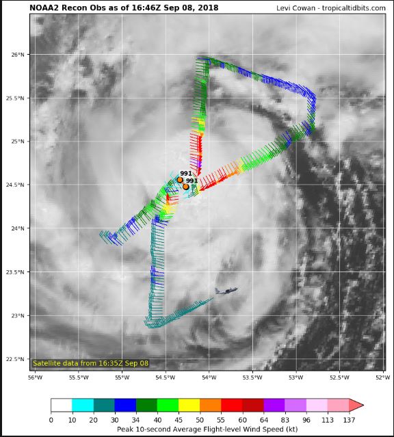
First aircraft recon into Florence on approach, follow along in near real time here, wouldn't expect anything too exciting though..
Do you know if their data got injected into the GFS12z run? Because the Latest GFS12z has a different look. No Carolina landfall...it curves Florence up the coast as a Cat3-4, stops off the NC coast.... strengthens more, then moves SOUTH.
Its probably saying no way I want to attempt to attack the blocking up north. Lol. That must be some intense blocking "IF" theres going to be a slow down or stop like that. Gees
Thats true, thats why you only look for where consensus and consistency is for best "guess". Hopefully when I post "the latest" with each run it doesnt confuse people. Im simply stating what an end result is per model and its never gauranteed...for instance... see below
Do you know if their data got injected into the GFS12z run? Because the Latest GFS12z has a different look. No Carolina landfall...it curves Florence up the coast as a Cat3-4, stops off the NC coast.... strengthens more, then moves SOUTH.
Its probably saying no way I want to attempt to attack the blocking up north. Lol. That must be some intense blocking "IF" theres going to be a slow down or stop like that. Gees
That's what I'm seeing too! GA and FL need not let their guard down with this thing - it is still 6 days away and seems to be trending SOUTH. Where I am in FL (Jupiter), people have been dismissing it as a northern storm.
Take a look.. Latest GFS12z. lol. Nuts. GFS is drinking again.
Monday afternoon to Tuesday Sept 18th loop. Watch it approach...stop......strengthen (946mb to 909mb).....head south......stop......head back northeast. lol
Thats true, thats why you only look for where consensus and consistency is for best "guess". Hopefully when I post "the latest" with each run it doesnt confuse people. Im simply stating what an end result is per model and its never gauranteed...for instance... see below
Do you know if their data got injected into the GFS12z run? Because the Latest GFS12z has a different look. No Carolina landfall...it curves Florence up the coast as a Cat3-4, stops off the NC coast.... strengthens more, then moves SOUTH.
Its probably saying no way I want to attempt to attack the blocking up north. Lol. That must be some intense blocking "IF" theres going to be a slow down or stop like that. Gees
Get ready for more hot and humid weather up north, then. Ridge has to be incredibly strong for a hurricane to move southwest.
If you've been to Tybee, St. Simons, and Jekyll Islands in Georgia, you'll notice that the houses there aren't on stilts. It's quite a contrast from what you'd see along, say, the North Carolina coast. There's a reason for this. Georgia has not had a direct perpendicular strike by a major hurricane since the 1890s. There were only 2 hurricanes to directly impact Georgia since then, one of them being hurricane Matthew which came in at an angle scraping the coastline (and thus weakening). The other was 1979's David which did the same thing.
A perpendicular strike on Georgia by this hurricane would be devastating. The caved in coastline makes Georiga miss hurricanes more, but also amplifies storm surge in that very rare case that they do get a direct hit. All those houses on the barrier islands, gone.
I was down there a few years ago and remember all the houses at ground level. That area is so flat too. Any large surge would go very far inland there with all those water ways spidering well inland.
Get ready for more hot and humid weather up north, then. Ridge has to be incredibly strong for a hurricane to move southwest.
True!
Also...I been watching this potential cold shot coming into Eastern U.S around the 18th.. Wouldn't it be funny if Florence was still around for it?
1. The deep trough would kick it back Northeast as GFS shows.
2. It could capture the storm and pull it back in like Sandy IF IF IF timing is perfect. It's not with latest GFS
Upper Height Anomaly. Florence caught by the Trough but way too far. Late Fall like pattern for Northeast
Hurricanes are stressful. Even if you are prepared, well stocked, have plans to leave, etc. The stress level? Does not decrease. Ever.
I met a woman last year who was a transplant to FL. She said she always thought people were so stupid, as in why don't they leave? Why are they waiting? She said she used to yell at the tv during storm coverage. Then she experienced Irma. With it's will it/won't it, wobble wobble wobble, which coast will it hit? where will it turn?
Then she understood. You do not know until about 24 hrs prior where landfall will be. And that last 20-30 mile wobble? Means all the difference in the world. People who have never experienced a hurricane do not ever understand this. So you can have plans a, b, c, d for every possible situation. You are still stressed because of the uncertainty. You do not know which plan you will use. Or when to pick one.
That being said, thanks to everyone who posts meaningful info here. The info is very well received by those of us in hurricane land.
Ya, I used to live on the coast...there's something about the uncertainty that makes you want to stay and sometimes that forecast changes and you're glad you didn't leave. Just don't want to pull the short stick and get stuck in one hitting hard. I remember one about 15+years ago where we went out between rain bands to drive around real quick and quickly realized the little waterways had surge coming up covering roads and we were essentially on an island at that point with multiple routes cut off hours before the core came through that evening...it didn't help the street drains worked in reverse and allowed the surge to come out the drains along the street gutters. It's a strange feeling to realize you're stuck and it'll only get worse (we were two small blocks over from the nearest evacuation zone). And another we had Cat1 conditions so overall ok but after the 3rd day of no power/communications that's when the looting began because the shock and small stocks people had started running out and officials were busy with other matters...we left town that evening until things calmed down and power started slowly coming back.
Do you know if their data got injected into the GFS12z run?
Doubtful...they're still in measuring the storm, winds just below hurricane strength (top left is flight level winds which are always higher then what's at ground level, top right is ground level / surface wind obs which is used for what the storm is rated at which look to be holding around 70mph, the eye/center of storm is where you see sudden drop in winds then sudden rise again so structurally it's in good shape):
Doubtful...they're still in measuring the storm, winds just below hurricane strength (top left is flight level winds which are always higher then what's at ground level, top right is ground level / surface wind obs which is used for what the storm is rated at which look to be holding around 70mph, the eye/center of storm is where you see sudden drop in winds then sudden rise again so structurally it's in good shape):
Canadian model just updated. Hits south Carolina then just dwindles. No rain for Northeast even after couple days. lol. Canadian showing a sharp cold front and a trough as well for around the 18th
This is fascinating watching the effect of the present slow down of Florence and the results in the future. If it slows down even more, a recurve with no landfall is very likely. That Jet stream will kick her out easily if timing is right.
What models do you find more accurate than others?
Please register to post and access all features of our very popular forum. It is free and quick. Over $68,000 in prizes has already been given out to active posters on our forum. Additional giveaways are planned.
Detailed information about all U.S. cities, counties, and zip codes on our site: City-data.com.

 Please register to participate in our discussions with 2 million other members - it's free and quick! Some forums can only be seen by registered members. After you create your account, you'll be able to customize options and access all our 15,000 new posts/day with fewer ads.