Welcome to City-Data.com Forum!
U.S. CitiesCity-Data Forum Index
Go Back   City-Data Forum > General Forums > Weather
 [Register]
Please register to participate in our discussions with 2 million other members - it's free and quick! Some forums can only be seen by registered members. After you create your account, you'll be able to customize options and access all our 15,000 new posts/day with fewer ads.
View detailed profile (Advanced) or search
site with Google Custom Search

Search Forums  (Advanced)
 
Old 05-24-2012, 04:36 AM
 
Location: Near the Coast SWCT
83,523 posts, read 75,333,969 times
Reputation: 16620

Advertisements

Random forecast spot. Yellowstone, Montana. Elevation 6681'.

Reply With Quote Quick reply to this message

 
Old 05-24-2012, 05:07 AM
 
Location: Near the Coast SWCT
83,523 posts, read 75,333,969 times
Reputation: 16620
Default Winter Storm Warning 5-24-12

Warning just posted for Sheridan County Wyoming.

402 AM MDT THU MAY 24 2012

THE NATIONAL WEATHER SERVICE IN BILLINGS HAS ISSUED A WINTER STORM WARNING FOR HEAVY SNOW...WHICH IS IN EFFECT FROM 6 PM THIS EVENING TO 6 AM MDT SATURDAY.

* TIMING...SNOW WILL DEVELOP THIS AFTERNOON AND INTENSIFY TONIGHT. THE HEAVIEST SNOWFALL WILL LIKELY OCCUR FRIDAY INTO FRIDAY NIGHT. SNOW WILL DIMINISH SATURDAY MORNING.

* SNOW ACCUMULATION...AROUND A FOOT OF SNOW IS EXPECTED.

* IMPACTS...HEAVY WET SNOW ON POWER LINES AND TREES MAY RESULT IN POWER OUTAGES AS WELL AS TREE DAMAGE. MOUNTAIN ROADWAYS WILL BECOME SNOW PACKED AND ICY TONIGHT THROUGH SUNDAY...AND MAY BECOME IMPASSABLE IN SPOTS...INCLUDING HIGHWAY 14.
Reply With Quote Quick reply to this message
 
Old 05-24-2012, 10:25 AM
 
Location: Near the Coast SWCT
83,523 posts, read 75,333,969 times
Reputation: 16620
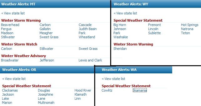
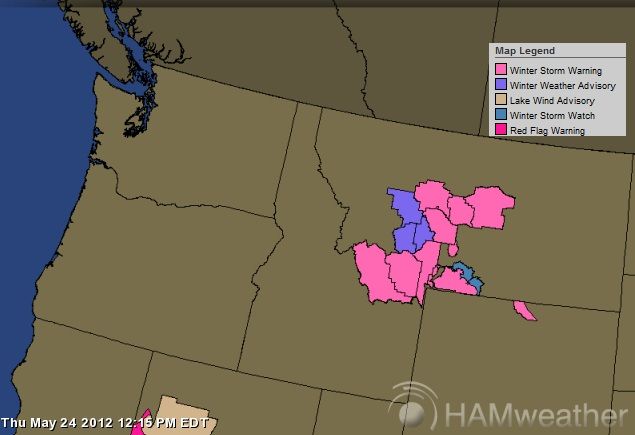
Quick post on where the Warnings are: Doesnt mean its not snowing anywhere else (those areas just dont have advisories or watches out)


Special Weather Statement for Counties in Wyoming: Big Horn, Fremont, Hot Springs, Johnson, Lincoln, Natrona, Park, Sublette, Teton,
Washakie

401 AM MDT THU MAY 24 2012

...SPRING STORM TO BRING RAIN AND SNOW FRIDAY THROUGH SUNDAY...

A STRONG STORM SYSTEM WILL DEVELOP OVER THE WESTERN UNITED STATES
THURSDAY AND FRIDAY WHICH WILL BRING SIGNIFICANTLY COOLER AND WETTER
CONDITIONS FRIDAY THROUGH SUNDAY.

ON FRIDAY...A WEAK DISTURBANCE WILL BRING ENHANCED PRECIPITATION TO
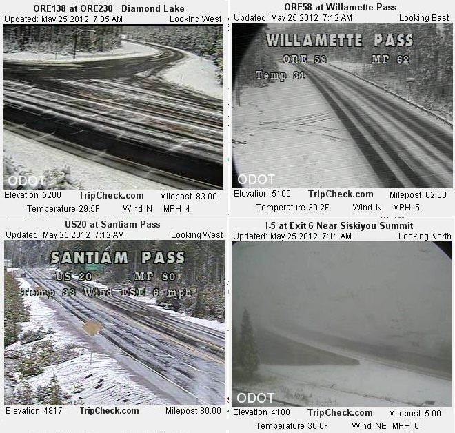
WYOMING. SNOW LEVELS FRIDAY MORNING ARE EXPECTED TO BE 6500 TO
7000 FEET THEN RISING TO 8000 TO 9000 FEET IN THE AFTERNOON. MOUNTAIN
SNOWFALL OF 3 TO 6 INCHES WITH LOCALLY HIGHER AMOUNTS IS POSSIBLE
ACROSS THE MOUNTAINS OF WESTERN AND CENTRAL WYOMING.

ON SATURDAY AND SUNDAY...A WARM FRONT WILL PUSH NORTH ACROSS THE
AREA...BRINGING ADDITIONAL WIDESPREAD PRECIPITATION TO THE REGION. A
COLD FRONT WILL THEN PUSH EAST ACROSS THE REGION SATURDAY NIGHT AND
SUNDAY. THIS COLD FRONT WILL DROP SNOW LEVELS TO NEAR VALLEY
FLOORS. AN ADDITIONAL 3 TO 6 INCHES OF MOUNTAIN SNOW WITH LOCALLY
HIGHER AMOUNTS WILL BE POSSIBLE SATURDAY AND SUNDAY...WITH THE
HIGHEST AMOUNTS EXPECTED IN THE TETONS. MOUNTAIN SNOWFALL COULD BE
HEAVY AT TIMES AS THIS COLD FRONT PUSHES EAST.
Reply With Quote Quick reply to this message
 
Old 05-24-2012, 10:34 AM
 
Location: Near the Coast SWCT
83,523 posts, read 75,333,969 times
Reputation: 16620
Too much info to post. Not sure which one.

This looked interesting from NWS Colorado


...A STRONG STORM SYSTEM WILL CREATE A BLUSTERY HOLIDAY WEEKEND...

AN IMPRESSIVE STORM SYSTEM WILL AFFECT EASTERN UTAH AND WESTERN COLORADO THIS HOLIDAY WEEKEND BEGINNING FRIDAY AND PERSISTING THROUGH SATURDAY EVENING. THIS SYSTEM FEATURES A VERY POTENT AREA OF LOW PRESSURE THAT WILL CAUSE WINDS TO INCREASE DRAMATICALLY OVER THE REGION AS IT MOVES FROM THE GREAT BASIN FRIDAY NIGHT TO THE NORTHERN ROCKIES AND AREAS EAST BY SUNDAY. ALONG WITH THE WINDS...AN ASSOCIATED COLD FRONT WILL ALSO MOVE THROUGH THE AREA DROPPING HIGH TEMPERATURES SIGNIFICANTLY FROM SATURDAY TO SUNDAY.

AS THE STORM SYSTEM APPROACHES THE GREAT BASIN...WINDS WILL PICK UP FRIDAY MORNING. SUSTAINED WINDS OF 25 TO 35 MPH WILL BE COMMON ACROSS MUCH OF THE AREA WITH GUSTS REACHING UPWARDS OF 45 MPH AND HIGHER AT TIMES. WINDS WILL LIGHTEN UP SOMEWHAT FRIDAY NIGHT AS THE ATMOSPHERE DECOUPLES BUT SOME STRONGER GUSTS ARE STILL POSSIBLE. STRONG WINDS ARE EXPECTED AGAIN SATURDAY AS A COLD FRONT STARTS MOVING OVER THE AREA FROM NOON SATURDAY AND EXITING THE REGION LATE SATURDAY NIGHT. TEMPERATURES WILL DROP DRAMATICALLY...POSSIBLY 20 DEGREES IN SOME PLACES...FROM SATURDAY TO SUNDAY. BY SUNDAY...THE STORM WILL BE WELL OUT OF OUR AREA BRINGING A RETURN TO MORE TRANQUIL WEATHER.
Reply With Quote Quick reply to this message
 
Old 05-24-2012, 10:38 AM
 
Location: Near the Coast SWCT
83,523 posts, read 75,333,969 times
Reputation: 16620
Here's a snapshot of where the special statements ect are via states and counties for Winter Weather today and next couple days.

Reply With Quote Quick reply to this message
 
Old 05-24-2012, 11:16 AM
 
Location: Near the Coast SWCT
83,523 posts, read 75,333,969 times
Reputation: 16620
They are currently skiing on Mt. Bachelor out West. Man I hate the East. lol. Look at them having fun at the end of May. Live shot. http://www.turns-all-year.com/wealinksfr.html

Reply With Quote Quick reply to this message
 
Old 05-24-2012, 04:33 PM
 
Location: Near the Coast SWCT
83,523 posts, read 75,333,969 times
Reputation: 16620
Let me guess... media isnt covering this but they were all over memorial day being hot. Interesting.

Just amazing to see this system come on shore.

New Watches posted.,.. Here's the updated list as of 6:30pm.

Reply With Quote Quick reply to this message
 
Old 05-24-2012, 05:38 PM
 
Location: Near the Coast SWCT
83,523 posts, read 75,333,969 times
Reputation: 16620
Video taken today in Montana.. Home Sweet Home.


Snow view off cabin deck - YouTube
Reply With Quote Quick reply to this message
 
Old 05-25-2012, 08:05 AM
 
Location: Near the Coast SWCT
83,523 posts, read 75,333,969 times
Reputation: 16620
Look at these reporting temps by NWS stations.

http://weather.rap.ucar.edu/surface/sfc_cod.gif

Reply With Quote Quick reply to this message
 
Old 05-25-2012, 08:32 AM
 
Location: Near the Coast SWCT
83,523 posts, read 75,333,969 times
Reputation: 16620
Webcam views this morning. Snowing down to 4100 feet in Oregon. Turns All Year Mountain Weather Browser for backcountry skiing

Reply With Quote Quick reply to this message
Please register to post and access all features of our very popular forum. It is free and quick. Over $68,000 in prizes has already been given out to active posters on our forum. Additional giveaways are planned.

Detailed information about all U.S. cities, counties, and zip codes on our site: City-data.com.


Reply
Please update this thread with any new information or opinions. This open thread is still read by thousands of people, so we encourage all additional points of view.

Quick Reply
Message:


Over $104,000 in prizes was already given out to active posters on our forum and additional giveaways are planned!

Go Back   City-Data Forum > General Forums > Weather

All times are GMT -6. The time now is 11:35 AM.

© 2005-2024, Advameg, Inc. · Please obey Forum Rules · Terms of Use and Privacy Policy · Bug Bounty

City-Data.com - Contact Us - Archive 1, 2, 3, 4, 5, 6, 7, 8, 9, 10, 11, 12, 13, 14, 15, 16, 17, 18, 19, 20, 21, 22, 23, 24, 25, 26, 27, 28, 29, 30, 31, 32, 33, 34, 35, 36, 37 - Top