Please register to participate in our discussions with 2 million other members - it's free and quick! Some forums can only be seen by registered members. After you create your account, you'll be able to customize options and access all our 15,000 new posts/day with fewer ads.
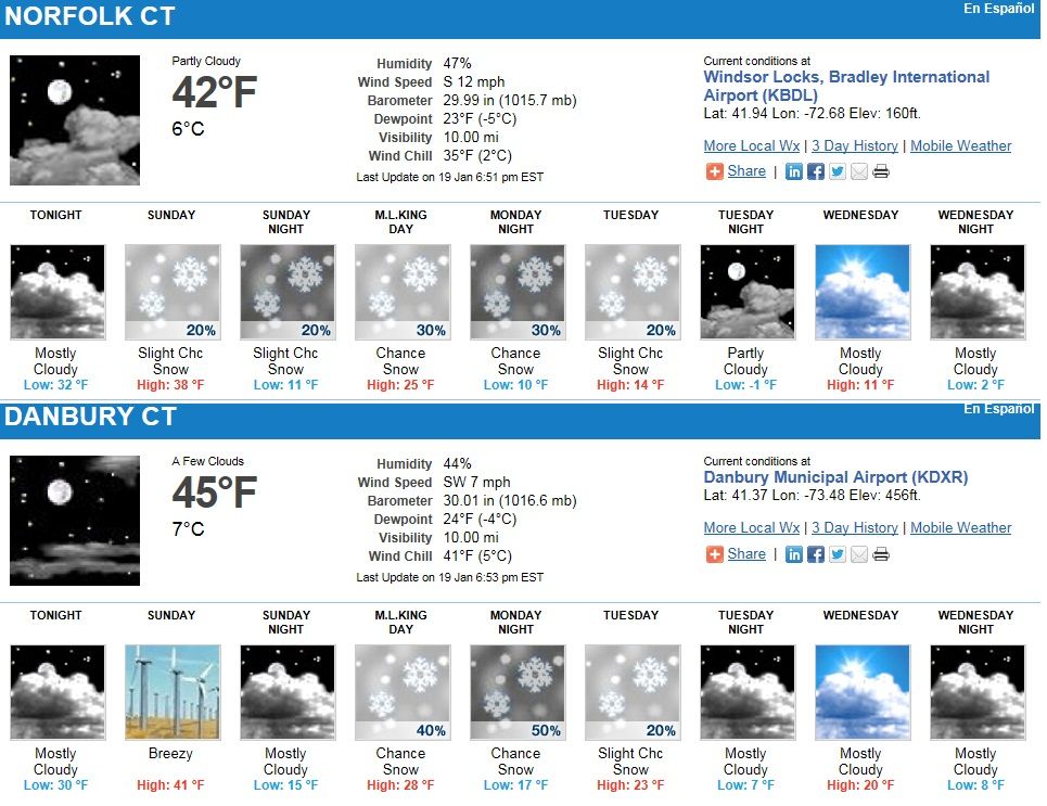
Interesting, warm everywhere for the moment! No snow here, wonder if we'll get back to some normal amounts? For the moment, big news is the 30 degree temp difference between today and tomorrow!
"6:58 PM EST Saturday 19 January 2013
Wind warning for
Niagara Falls - Welland - Southern Niagara Region continued
West winds gusting to 90 km/h beginning tonight.
Southwesterly wind gusts in the 50 to 70 km/h range continue over regions close to the Great Lakes this evening. As a strong low pressure system passes by to the north tonight, winds will shift to westerly and increase to 60 km/h gusting to 90 for all the above mentioned regions overnight. The high winds will shift to northwest and diminish slowly on Sunday as the low pressure system moves into Quebec."
Interesting, warm everywhere for the moment! No snow here, wonder if we'll get back to some normal amounts? For the moment, big news is the 30 degree temp difference between today and tomorrow!
Well, the cold air has now enveloped the Upper Midwest. Minneapolis has a forecast high of -4F tomorrow along with a Wind Chill Warning.
Quote:
Originally Posted by ilovemycomputer90
After tomorrow, we should be well below freezing for the rest of the week. Still an odd lack of bitterly cold nights though.
It's not uncommon to have ranges like that anywhere in the East, but perhaps it has something to do with the lack of snow cover anywhere near your location, although 2011 featured ranges not too dissimilar even with a lot of snow cover.
For some weird reason, extremes nowadays manifest themselves in low maximums and high minimums, more so than classic record highs and lows. There are plenty of classic records being set (such as Oklahoma's -31F 2 years ago), but it's changed from the 1970's when classic record lows were preferred over record low maximums, or from the 1930's when classic record highs were set over record high minimums. Curiously, most of these low maximums/high minimums records date back from previous PDO cycles around 1900 and points prior, so perhaps it's just a cycle the climate goes through.
Yesterday 20 degrees above normal, right now 20 degrees below normal! I love variation and I got it! 25 normal, 5 now.
Wind isn't as strong, overnight some gusts 60 mph, wild stuff. Haven't heard of power outages, a good thing. Several nights of single/below zero temps coming up, mid-week "warm" up might bring a little snow!
A classic change to be sure. 60 mph winds heralding some near-zero temperatures and snow are nothing I can complain about, though I detest any wintertime thaws and could do with more subzero cold.
Current temps. 50s and 60s on the NorthEast coast all the way to Massachusettes!
Its 51°F here right now. Hard to think it will feel like 5° in a few days. Notice temps arent getting past zero in N.Dakota and Minnesota today. That will shift East through the week. Jet stream and arctic front screaming by. Winds howling at 45mph here.
Please register to post and access all features of our very popular forum. It is free and quick. Over $68,000 in prizes has already been given out to active posters on our forum. Additional giveaways are planned.
Detailed information about all U.S. cities, counties, and zip codes on our site: City-data.com.

 Please register to participate in our discussions with 2 million other members - it's free and quick! Some forums can only be seen by registered members. After you create your account, you'll be able to customize options and access all our 15,000 new posts/day with fewer ads.


 No snow here, wonder if we'll get back to some normal amounts? For the moment, big news is the 30 degree temp difference between today and tomorrow!


