Please register to participate in our discussions with 2 million other members - it's free and quick! Some forums can only be seen by registered members. After you create your account, you'll be able to customize options and access all our 15,000 new posts/day with fewer ads.
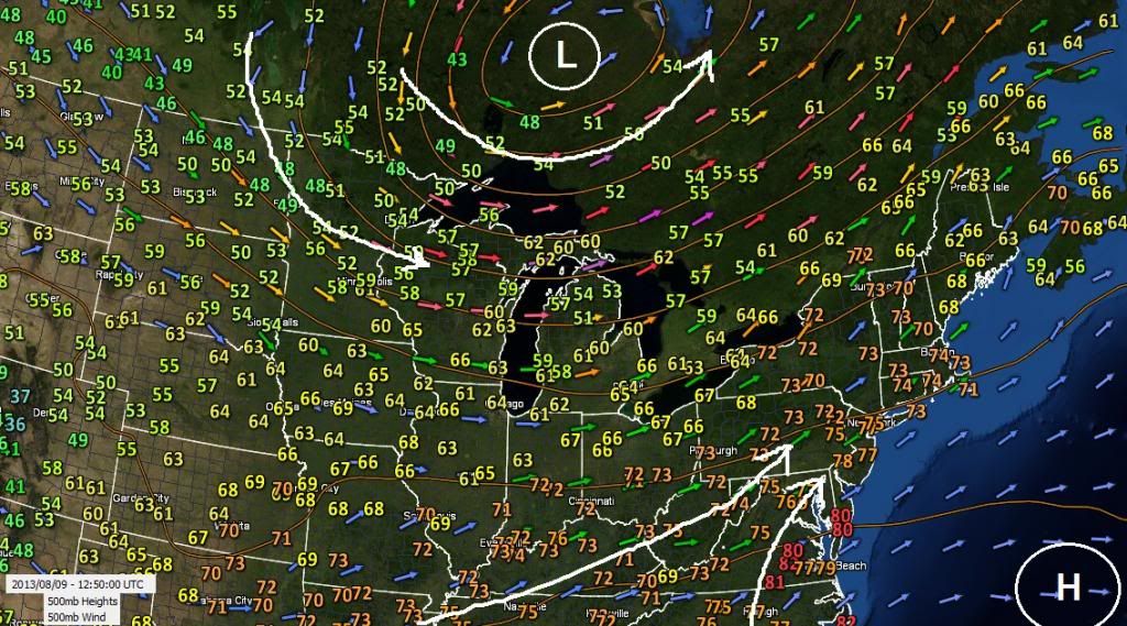
Here's current map of the flow at 17,000 feet, heights, and surface temps.
Upper Level Low Pressure in Canada (spinning counter clockwise), Bermuda High Pressure in Atlantic (spinning clockwise)...
The Low pressure in Canada is allowing the flow to be from the North & NorthWest which is keeping upper plains and midwest cool. The south/Southwest flow from the Bermda High is helping keep the morning very warm and humid in the East.
...SCATTERED THUNDERSTORMS ESPECIALLY THIS AFTERNOON...
THIS HAZARDOUS WEATHER OUTLOOK IS FOR SOUTH FLORIDA.
.DAY ONE...TODAY AND TONIGHT
THUNDERSTORMS: SCATTERED THUNDERSTORMS ARE EXPECTED...ESPECIALLY
SOUTHERN AREAS THIS AFTERNOON. FREQUENT CLOUD-TO-GROUND LIGHTNING
WILL BE THE PRIMARY THREAT. GUSTY WINDS UP TO 45 MPH CANT BE RULED
OUT WITH THE STRONGEST THUNDERSTORMS.
WATERSPOUTS: WATERSPOUTS ARE POSSIBLE WITH SOME OF THE
THUNDERSTORMS OVER THE ATLANTIC WATERS.
RIP CURRENTS: THERE IS A MODERATE RISK OF RIP CURRENTS FOR THE
ATLANTIC BEACHES TONIGHT.
.DAYS TWO THROUGH SEVEN...SATURDAY THROUGH THURSDAY
THERE IS A MODERATE RISK OF RIP CURRENTS ACROSS THE ATLANTIC
COAST BEACHES THIS WEEKEND.
THE COMBINATION OF HOT TEMPERATURES AND HIGH RELATIVE HUMIDITY
WILL CAUSE HEAT INDICES TO EXCEED 100F EACH DAY THROUGH EARLY NEXT
WEEK. INTERIOR PARTS OF SOUTH FLORIDA COULD SEE THE APPARENT
TEMPERATURE REACH BETWEEN 105 AND 110 DEGREES.
pouring hard. high dew points helping? I like this setup: high dew points when it's cool, cloudy and rainy (or about to rain), low dew points when it clears.
pouring hard. high dew points helping? I like this setup: high dew points when it's cool, cloudy and rainy (or about to rain), low dew points when it clears.
Rained for 3hrs here overnight. Only got 1/4" here. Stopped for past few hours now. Lots of flood warnings and watches out there. Bulk of it stayed north of me. Which I think means the front did not come south. You're in the heart of the moisture plume. You might pick up 1.20 maybe 2.50+" if it can really drop hard. Let us know what you get.
I agree... cloudy, rainy, cool for August with high dewpoints, then drops when it clears. A sign of fronts and Canadien highs.
Closest official station reported 0.52". Unofficial station right nearby 0.89", probably closer to what I got. Nothing remarkable for summer, though still big. Sounds like it will start to taper off.
Closest official station reported 0.52". Unofficial station right nearby 0.89", probably closer to what I got. Nothing remarkable for summer, though still big. Sounds like it will start to taper off.
You dont have a rain gauge? Very inexpensive. Everyone should have one and keep track of their location. We talk about temps varying location to location it's amazing how rainfall will vary town to town.
Maybe I'll try one. Heavy rain band just came through. Unofficial station reporting 1.62" so far.
Close to my thinking but the day isnt even done yet so I'll be low. Aside from the heavy rain, there is also a "slight" risk for an isolated tornado.
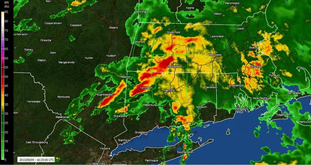
Look at those heavy training cells. From Poughkeepsie to Springfield its like been non stop.
.30" here.
Please register to post and access all features of our very popular forum. It is free and quick. Over $68,000 in prizes has already been given out to active posters on our forum. Additional giveaways are planned.
Detailed information about all U.S. cities, counties, and zip codes on our site: City-data.com.

 Please register to participate in our discussions with 2 million other members - it's free and quick! Some forums can only be seen by registered members. After you create your account, you'll be able to customize options and access all our 15,000 new posts/day with fewer ads.


 You dont have a rain gauge? Very inexpensive. Everyone should have one and keep track of their location. We talk about temps varying location to location it's amazing how rainfall will vary town to town.