Please register to participate in our discussions with 2 million other members - it's free and quick! Some forums can only be seen by registered members. After you create your account, you'll be able to customize options and access all our 15,000 new posts/day with fewer ads.
Weekly Long Range Forecast Model Update
August 10, 2013; 11:55 AM
Here is my latest interpretation of the ECMWF long range forecast product that now goes through the week of September 2nd through the 8th.
The model continues to show widespread above-normal temperatures across northern Canada while the overall pattern forces more systems farther to the south through the U.S., while keeping the high heat confined to the southwest and south central U.S.
I will be issuing the AccuWeather.com Fall outlook for Canada later in the week.
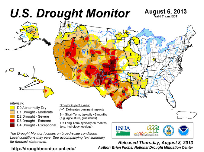
Man that Texas Panhandle has really been getting hit hard with drought the last several years. When is it gonna let up there, especially since that part of the Ogalala Aquifer is running low
STRONG COLD AIR ADVECTION BEHIND THE FRONT ON TUESDAY NIGHT WITH 850 TEMPERATURES DROPPING TO +4C TO +6C SHOULD ALLOW FOR LOW TEMPERATURES TO DROP INTO THE 40S TO LOW 50S. DUE TO SOME QUESTION AS TO HOW MUCH CLOUD COVER WILL BE LEFT OVER HAVE OPTED TO LEAN SLIGHTLY WARMER. IF SKIES CAN CLEAR OUT FURTHER IT MAY BE A FEW DEGREES COOLER THAN SHOWN HOWEVER
Please register to post and access all features of our very popular forum. It is free and quick. Over $68,000 in prizes has already been given out to active posters on our forum. Additional giveaways are planned.
Detailed information about all U.S. cities, counties, and zip codes on our site: City-data.com.

 Please register to participate in our discussions with 2 million other members - it's free and quick! Some forums can only be seen by registered members. After you create your account, you'll be able to customize options and access all our 15,000 new posts/day with fewer ads.